BajaNomad

Catavina SxS trails?

DouglasP - 11-19-2022 at 07:55 AM

We are headed to Catavina from Punta Chivato for a couple nights over Thanksgiving. Bringing the side by side along to explore around.
Any suggestions or tracks would be great. All day loop would be awesome. Shorter trips good also.

Thanks, Douglas

Meany - 11-19-2022 at 08:29 AM

Buenos Diaz Sr. Douglas and TWFP> If your staying at the Hotel. Go North from there a few miles and turn left on the Faro San Jose turn off. That will take you out to the Pacific. Russ and the Kelley's and The Meany's went that way for three days of camping and surf fishing. Camped between San Jose de la Piedra and Los Morros Colorados. Great ride. There are a lot of riding out there in that area. Have fun and Have a fun Happy ThanksGiving to you Kids. Be safe out there. Take Pictures. Meany

bajatrailrider - 11-19-2022 at 08:57 AM

There is also cool run just 10 min south turn right west. Road goes west sand wash on south side road .have fun

David K - 11-19-2022 at 09:39 AM

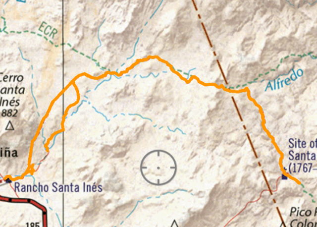
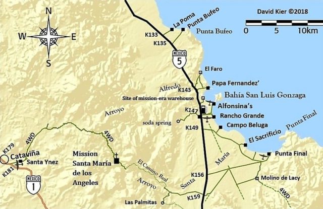
Mission Santa María road is the prime ticket. It begins to the left of the Rancho Santa Ynez (Inez, Inés) buildings and is 14.5 miles to the mission. It continues just over a mile past the mission. The ranch driveway is one kilometer south of the Cataviña hotel and it is 1 km to the ranch campground, restaurant, and mission road start.

It is very rough, steep, staircase grades after the highpoint, about 10 iles from Santa Ynez, for the final 4.5 miles to the mission.

See my Baja Nomad trip report here on Nomad from March 2022 or my web page: https://vivabaja.com/msm2022/


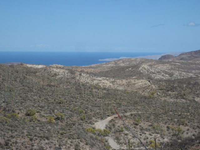
View of Punta Final/ Gonzaga Bay from the highpoint/ peninsular divide, 10 miles from Santa Ynez:


The 1768 adobe church ruins:

mtgoat666 - 11-19-2022 at 10:20 AM

Quote: Originally posted by DouglasP  
We are headed to Catavina from Punta Chivato for a couple nights over Thanksgiving. Bringing the side by side along to explore around.
Any suggestions or tracks would be great. All day loop would be awesome. Shorter trips good also.

Thanks, Douglas

If you like rocks, there are a number tracks in the boulder fields north side of Catavina. Easy to spend a good day or more just scrambling up the rock piles, hiking around, doing some minor bouldering.

There are several old routes that take you east into the mountains, making good point to start a hike or rock scramble into mountains. Look on GE and you will see old tracks east of the virgin shrine,… some of these you can drive with sxs, then start hiking eastward from where vehicle travel ends.

On the road out to mission Santa Maria, at about northernmost extent, there is a track that takes you northward into the mountains/rocks, good starting point for a hike or day of rock scrambling.

Dk and 4x4harold have a recent thread discussing a new road into the Santa Maria mission area, something they saw on GE, it needs a nomad to explore it on the ground and report back to the arm chair explorers club :light:

bajatrailrider - 11-20-2022 at 12:46 PM

I If you dont have another SXS with you I would not go to Mission. Yes it will make it out of there but possible to break something . Always good having back up sxs on that run. Next run visit us north Baja have best routes. One good buddy moves here next week w 4 seat can am. Will enjoy that as many of my routes cannot do alone.

David K - 11-20-2022 at 12:51 PM

For a day run if, no others along, you can go as far as the peninsular divide, safely. As bajatrailrider says, do not go the next 4.5 miles on to the mission solo.

bajatrailrider - 11-20-2022 at 01:24 PM

Thank you David I have rode out of there many times on my moto. Even thats just my game hard places no go alone. Hit the ledge get stuck under bike . Like buddy did lucky we where there

DouglasP - 11-21-2022 at 01:07 PM

Great responses! Thanks to everyone. Now to research and pick one or two.
Good advice on not getting into trouble alone. Always careful and carry the InReach, just in case.

Good to see you still lurk on the board Steve! Getting your Baja fix? Happy Thanksgiving to you guys also!

David K - 11-21-2022 at 02:20 PM

Feel free to include me in your inReach contacts should I be able to help get the word out for you. Many other Nomads have me in their inReach or Spot units. :cool:

Meany - 11-21-2022 at 02:52 PM

Hola DouglasP. I know I should have to say this? But remember to take extra Gas and also but me on your inReach as well. I like bajatrailrider and 666 ideas. There are a lot of cool rock area's out there. Be safe. Sr. Meany

DouglasP - 11-21-2022 at 03:02 PM

Quote: Originally posted by Meany  
Hola DouglasP. I know I should have to say this? But remember to take extra Gas and also but me on your inReach as well. I like bajatrailrider and 666 ideas. There are a lot of cool rock area's out there. Be safe. Sr. Meany


I will be sure and put you in. Thank you.

advrider - 11-22-2022 at 08:52 AM

All good info, as bajatrailrider said, you don't want to do the mission solo. If you have any Atlas or AAA maps you will see that most roads on the West side of the highway will lead to the Pacific and are good RZR rides. You can even run back up North to El Rosario if you have enough gas. Very fun area to explore on a bike or in the RZR.

David K - 11-22-2022 at 09:17 AM

Quote: Originally posted by advrider  
All good info, as bajatrailrider said, you don't want to do the mission solo. If you have any Atlas or AAA maps you will see that most roads on the West side of the highway will lead to the Pacific and are good RZR rides. You can even run back up North to El Rosario if you have enough gas. Very fun area to explore on a bike or in the RZR.


Nearly all the AAA maps are being preserved and with 'zoom-in' detail on my website. Here is the Viva Baja Maps page: https://vivabaja.com/maps/

chickendoug - 11-23-2022 at 02:22 PM

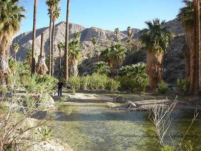
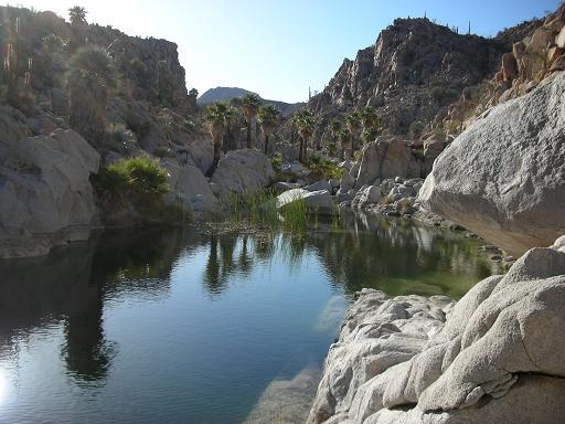
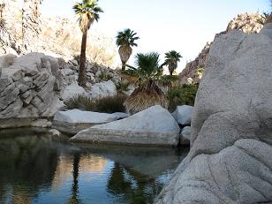
After you reach the Mission drive as far as you can (less than a mile) past the Mission , then walk about 30 minutes to the Oasis water pool !

David K - 11-23-2022 at 02:32 PM

Quote: Originally posted by chickendoug  
After you reach the Mission drive as far as you can (less than a mile) past the Mission , then walk about 30 minutes to the Oasis water pool !


Yes!


DouglasP - 11-26-2022 at 08:20 AM

Thanks for the information and trip ideas.
We did some poking around out towards the west on the road to San Jose El Faro as suggested by Meany. The strong winds really put a damper on things for my wife ;D so we cut it short. All in all it was a great trip.

On our way back south to Punta Chivato we turned off on the highway towards Abreojos in hopes of picking up the Baja Divide trail into San Ignacio. We found the trail, but maybe 8 miles in we found a locked gate! Vehicles had busted through the brush and gone around it. We weren't comfortable doing that so we turned back.
Does anyone have any additional information on this gate?
Screen shot with a pin drop where the gate is included.


Screenshot-20221126-073202-Avenza-Maps 1.jpg - 294kB

David K - 11-26-2022 at 09:44 AM

Thanks for the report! Great to see you using the Avanza App with the Benchmark map. I wonder if the Baja Divide website has an update with that locked gate?

Meany - 11-26-2022 at 09:57 AM

Sr. Douglas and TWFP> Glad to here you had fun. To bad about the wind. Out in that area there is so much to see. If you get to the coast you can go along way up or down. Some great surf fishing and Kayaking at some secret coves. Love your map. Always wanted to go on that trail. Happy Holidays to you both. :coolup:

TRAVISD - 11-29-2022 at 09:04 AM

I ran that section back in February and did not come across a locked gate.