BajaNomad

No Wimps Area

DizzyNick - 2-21-2023 at 08:40 PM

Hey all,
I am trying to plan a through route from Santa Rosalia to LABay. From what i can tell, the southern part of no wimps is passable but is blocked by private property around El Barril. Is there another route west of there that connects through? possibly near El Gato?

JZ - 2-21-2023 at 08:51 PM

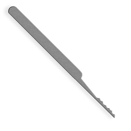
Just use a rake pick and you can breeze through on the Northern side.

Check out the Lock Picking Lawyer on YouTube shorts or TikTok to get instructions. He has hundreds of videos showing how to open any lock known to man.


[Edited on 2-22-2023 by JZ]

advrider - 2-21-2023 at 10:27 PM

I think most of that is a private reserve now. You can catch some sand tracks just outside GN to El Arco, then the dirt two track to BOLA. I think no wimps is gone for good.

JZ - 2-21-2023 at 10:36 PM


[Edited on 2-22-2023 by JZ]

TMW - 2-22-2023 at 07:48 AM

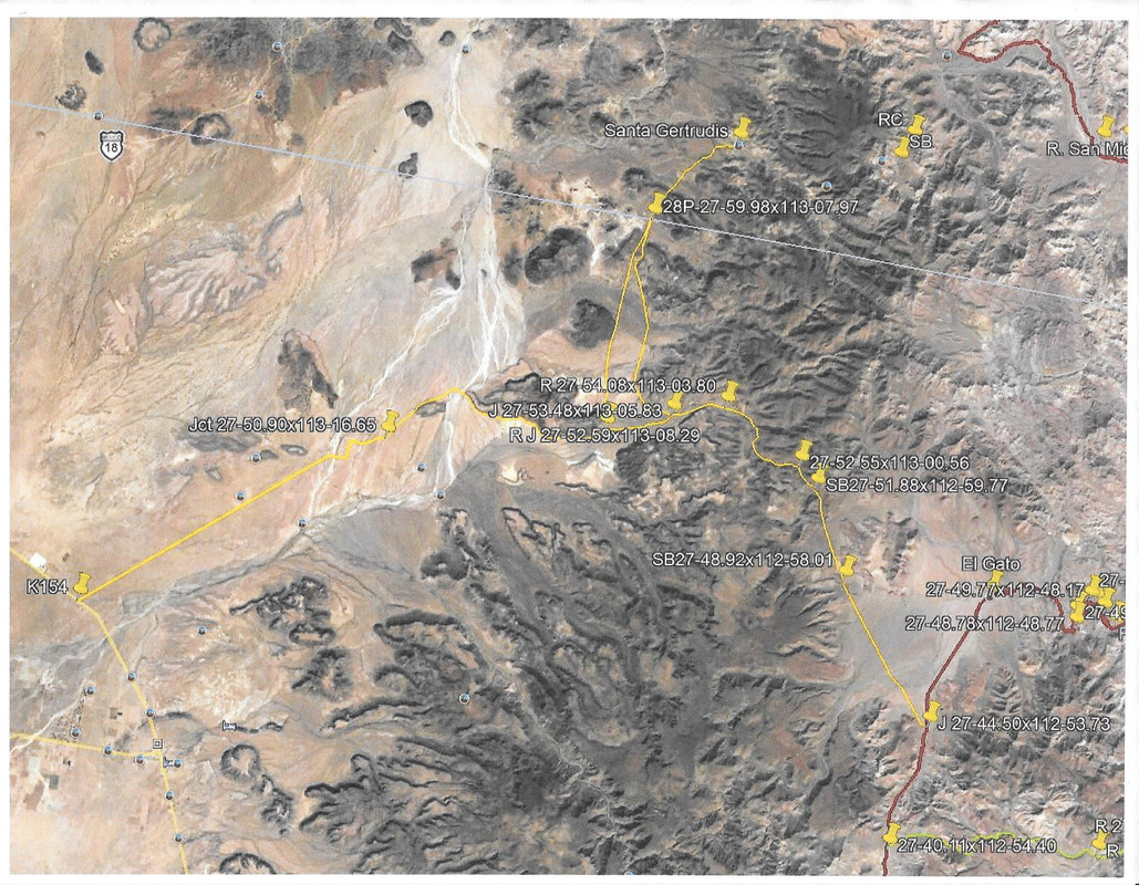
There is a trail that goes NW before El Gato and circles around to the west and joins the trail to Guillermo Prieto. This is the bypass road from Piedra Blanca to Hwy1 north of Vizcaino. I've mapped it on Google Earth but never road/drove it.

PaulW - 2-22-2023 at 08:18 AM

It is possible to drive around the south gate but then you still have the north gate to deal with. The property owner is pretty serious about trespassing.
Make sure you take the northern track near La Trinidad.
TMW's suggest is with a try if it bypasses the prohibited area. It is hard to identify the western boundary of the subject property.

DizzyNick - 2-22-2023 at 09:50 AM

As tempting as it may be I'm not interested in picking locks, hopping gate, etc.
I have seen that route from El Gato to Guillermo Prieto though, and it looks promising. Hopefully someone out there has done it and can confirm

David K - 2-22-2023 at 09:53 AM

What some maps show as a 'road' in this region, may in fact be a trail, like the mission road, El Camino Real. There are three branches of it between San Ignacio and Santa Gertrudis.

I get a lot of questions about the "road" connecting San Francisco (de la Sierra) with Santa Martha (Marta). This is a 'road' only for mules, goats and hikers with a permit!

I think the sign near San Francisco, about the trail, is shown on the YouTube Episode 4 of Cameron Steele's Trail of Missions Recon (~minute 3:30-4:00). Some beautiful drone footage over San Pablo Canyon, too: https://youtu.be/eBkpwi_pszU

DizzyNick - 2-22-2023 at 10:21 AM

Quote: Originally posted by PaulW  
It is possible to drive around the south gate but then you still have the north gate to deal with. The property owner is pretty serious about trespassing.
Make sure you take the northern track near La Trinidad.
TMW's suggest is with a try if it bypasses the prohibited area. It is hard to identify the western boundary of the subject property.


What is this northern track near La Trinidad? Are you talking about the road from Mulegé to Carambuche?

4x4abc - 2-22-2023 at 10:24 AM

Quote: Originally posted by DizzyNick  
As tempting as it may be I'm not interested in picking locks, hopping gate, etc.
I have seen that route from El Gato to Guillermo Prieto though, and it looks promising. Hopefully someone out there has done it and can confirm


well, at the moment there is nothing drivable between El Gato and Guillermo Prieto
what you see on Google Earth looks promising, but it is a foot trail only

however, someone is bulldozing a new track exactly through that region
could be prospecting or a new inter ranch road
who knows

check it out: 27.830647°, -113.021253°

track.jpg - 273kB

PaulW - 2-22-2023 at 10:33 AM

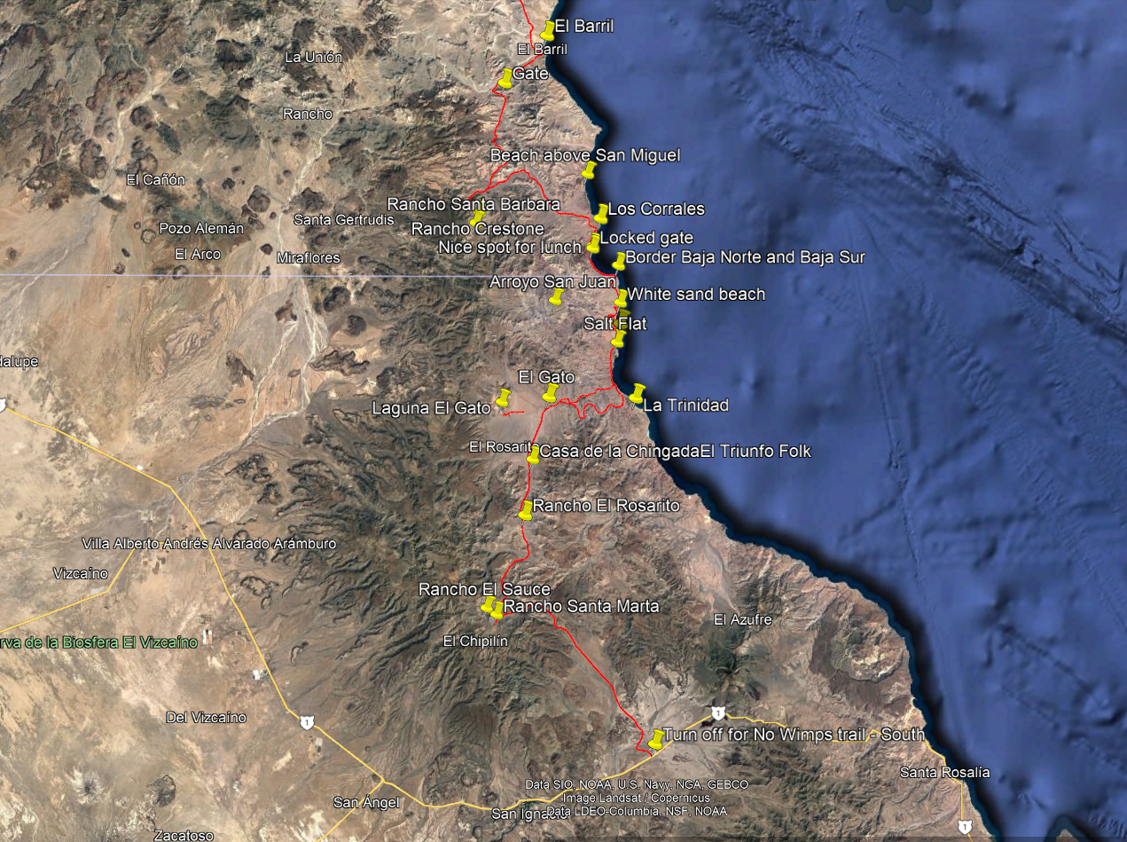
From El Gato to the coast is drivable. Not so much for the twisty S track.
Are you missing the GPS track for the two?

No-Wimps.png - 142kB

[Edited on 2-22-2023 by PaulW]

DizzyNick - 2-22-2023 at 10:45 AM

Quote: Originally posted by 4x4abc  
Quote: Originally posted by DizzyNick  
As tempting as it may be I'm not interested in picking locks, hopping gate, etc.
I have seen that route from El Gato to Guillermo Prieto though, and it looks promising. Hopefully someone out there has done it and can confirm


well, at the moment there is nothing drivable between El Gato and Guillermo Prieto
what you see on Google Earth looks promising, but it is a foot trail only

however, someone is bulldozing a new track exactly through that region
could be prospecting or a new inter ranch road

check it out: 27.830647°, -113.021253°


That's too bad, because like you mentioned, it looks so promising. We are on big dirt bikes, 690s and 650s. So that may help us out. Or get us in to more trouble:lol:

DizzyNick - 2-22-2023 at 10:48 AM

Quote: Originally posted by PaulW  
From El Gato to the coast is drivable. Not so much for the twisty S track.
Are you missing the GPS track for the two?


[Edited on 2-22-2023 by PaulW]


I do have those GPS tracks, but read that there are locked gates further north. We are doing a big down and back trip through baja, and I was hoping to use no Wimps or part of it as a connection between Santa Rosalia and Las Angeles Bay

DizzyNick - 2-22-2023 at 11:05 AM

Quote: Originally posted by David K  
What some maps show as a 'road' in this region, may in fact be a trail, like the mission road, El Camino Real. There are three branches of it between San Ignacio and Santa Gertrudis.

I get a lot of questions about the "road" connecting San Francisco (de la Sierra) with Santa Martha (Marta). This is a 'road' only for mules, goats and hikers with a permit!

I think the sign near San Francisco, about the trail, is shown on the YouTube Episode 4 of Cameron Steele's Trail of Missions Recon (~minute 3:30-4:00). Some beautiful drone footage over San Pablo Canyon, too: https://youtu.be/eBkpwi_pszU


Thank you, now I have more great content to watch as I patiently wait for our departure date!

TMW - 2-23-2023 at 05:43 AM

Quote: Originally posted by PaulW  
It is possible to drive around the south gate but then you still have the north gate to deal with. The property owner is pretty serious about trespassing.
Make sure you take the northern track near La Trinidad.
TMW's suggest is with a try if it bypasses the prohibited area. It is hard to identify the western boundary of the subject property.


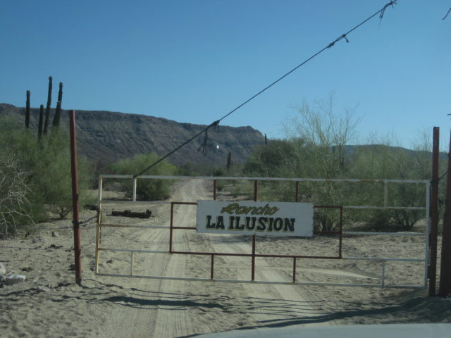
Paul is the north gate at R. La Illusion outside of El Barril?

TMW - 2-23-2023 at 05:47 AM

I wonder if the people that have closed off the area with locked gates would be willing to accept a fee to pass. Looks to me like that would be easy money to make.

David K - 2-23-2023 at 06:59 AM

Quote: Originally posted by TMW  
Quote: Originally posted by PaulW  
It is possible to drive around the south gate but then you still have the north gate to deal with. The property owner is pretty serious about trespassing.
Make sure you take the northern track near La Trinidad.
TMW's suggest is with a try if it bypasses the prohibited area. It is hard to identify the western boundary of the subject property.


Paul is the north gate at R. La Illusion outside of El Barril?


PaulW - 2-23-2023 at 08:13 AM

From personal contact with a person who knows the land owner access is not negotiable. Is the owner near by or accessible for such a discussion - I do not know.
The drive or ride including camping from the south to the south gate is a good trip and is still recommended.

advrider - 2-23-2023 at 09:21 AM

I hope you find a work around; I would love to do that ride.

[Edited on 2-23-2023 by advrider]

honda tom - 2-23-2023 at 10:19 AM

from what I understand .. Ricardo at rice and beans in san ignacio,
owns a large portion of land at La Trinidad. He would probably have good info. Beto at san francisquito would probably know the info needed at the north gate. Attempt should be made from north to south.

JZ - 2-23-2023 at 10:43 AM

Quote: Originally posted by honda tom  
from what I understand .. Ricardo at rice and beans in san ignacio,
owns a large portion of land at La Trinidad. He would probably have good info. Beto at san francisquito would probably know the info needed at the north gate. Attempt should be made from north to south.


I asked Beto about it via email about 3 years ago. Didn't get an exact answer.


[Edited on 2-23-2023 by JZ]

David K - 2-23-2023 at 10:51 AM

Beto has email, fyi.
Beto's website: http://www.puertosf.com/
His son is/was a Nomad: Bajaboi. His posts: http://forums.bajanomad.com/search.php?srchuname=Bajaboi&...

Beto's card (from a 2021 post):

Betto Card.jpg - 134kB

4x4abc - 2-23-2023 at 11:14 AM

I checked the latest sat images yesterday

a number of new roads have been pushed in to Rancho El Gato and to Bahia San Carlos

new beach real state including airstrip (already ditched by Mex army)
10 miles of new road going east out of the San Miguel area
possible prospecting

new road south from El Barril into San Miguel (12 miles)

somebody has big plans

real copy.jpg - 315kB

JZ - 2-23-2023 at 11:44 AM

One time I took my boat from BoLA to Santa Rosalia, passing right by the No Wimps area.

It was flat as could be until we rounded the point at San Francisquito, when all hell broke lose. We were in 8 foot wind waves. Roughest conditions I've been in ever. Continued to be bad until about 20 miles North of Santa Rosalia. We didn't have a chance to stop and see the No Wimp beaches. I was just trying to stay alive.

I went back and re-read the section in Gerry Cunningham's boating guide book. He mentions it is notoriously bad there, but didn't say it in a way that set off any alarm bells the first time I read it. He said that in places it goes from shore to super deep in less than a mile and the conditions of the channel make it particularly snotty.

After that ride I bought a life raft. :lol:


[Edited on 2-23-2023 by JZ]

4x4abc - 2-23-2023 at 12:22 PM

Quote: Originally posted by JZ  
One time I took my boat from BoLA to Santa Rosalia, passing right by the No Wimps area.

It was flat as could be until we rounded the point at San Francisquito, when all hell broke lose. We were in 8 foot wind waves. Roughest conditions I've been in ever. Continued to be bad until about 20 miles North of Santa Rosalia. We didn't have a chance to stop and see the No Wimp beaches. I was just trying to stay alive.

I went back and re-read the section in Gerry Cunningham's boating guide book. He mentions it is notoriously bad there, but didn't say it in a way that set off any alarm bells the first time I read it. He said that in places it goes from shore to super deep in less than a mile and the conditions of the channel make it particularly snotty.

After that ride I bought a life raft. :lol:


[Edited on 2-23-2023 by JZ]


Consag on his explorations north in the 1700's encountered the same thing.
Nasty!

DizzyNick - 2-23-2023 at 09:45 PM

Well I did some more digging and Google Earth shows a very definitive path from El Gato out a valley and over a ridge to Angostura then down more valleys to San Casimiro. Most of it looks like a double track except for the steep switchbacks just before dropping into Angostura.

JZ - 2-23-2023 at 09:49 PM

Quote: Originally posted by DizzyNick  
Well I did some more digging and Google Earth shows a very definitive path from El Gato out a valley and over a ridge to Angostura then down more valleys to San Casimiro. Most of it looks like a double track except for the steep switchbacks just before dropping into Angostura.


Awesome. Can you drop some way points? The crew will help you further.


DizzyNick - 2-24-2023 at 08:23 AM

Sorry, tried to post an image from Google Earth but it wasn't working.
Here's a poorly drawn gpx file I made on my phone

Attachment: El Gato Out.gpx (2kB)
This file has been downloaded 139 times


JZ - 2-24-2023 at 10:02 AM

Quote: Originally posted by DizzyNick  
Sorry, tried to post an image from Google Earth but it wasn't working.
Here's a poorly drawn gpx file I made on my phone


Nice.

What do you think Harald?


DizzyNick - 2-24-2023 at 10:05 AM

Well I did some more digging and Google Earth shows a very definitive path from El Gato out a valley and over a ridge to Angostura then down more valleys to San Casimiro. Most of it looks like a double track except for the steep switchbacks just before dropping into Angostura.

4x4abc - 2-24-2023 at 10:11 AM

Quote: Originally posted by DizzyNick  
Well I did some more digging and Google Earth shows a very definitive path from El Gato out a valley and over a ridge to Angostura then down more valleys to San Casimiro. Most of it looks like a double track except for the steep switchbacks just before dropping into Angostura.


what you found is an old El Boleo dozer track
hasn't been maintained the last 70 years
2 steep passes (300 ft and 600 ft)
would love to see someone ride it

Cuesta Blanca, the 300 ft, below


Cuesta Blanca copy.jpg - 301kB

David K - 2-24-2023 at 11:36 AM

What is the approx. GPS of this spot in your photo, Harold, and what is that straight line against the background moutains, above and just left of the vaquero? Thank you!!

4x4abc - 2-24-2023 at 01:25 PM

I don't know what that is in the background
Crosby has taken pictures in that spot as well - but I could not find it
27.816887°, -112.967668°


[Edited on 2-24-2023 by 4x4abc]

TMW - 2-24-2023 at 02:34 PM

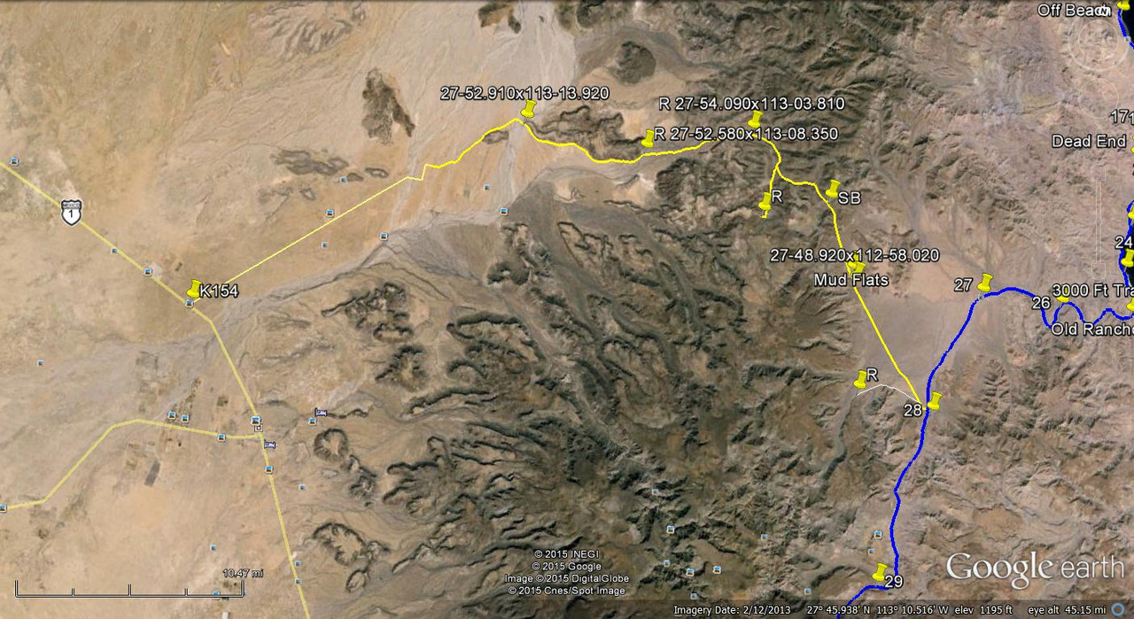
This is the path I mentioned above. Sorry if it came out wrong but I can't find the instructions on how to post with postimages that Blanca sent me.


[Edited on 2-24-2023 by TMW]

JZ - 2-24-2023 at 02:57 PM

Change the first "img" to "img=800x".

That will size the photo properly.


TMW - 2-24-2023 at 03:01 PM

Thanks JZ

TMW - 2-24-2023 at 03:04 PM

I think 27 is El Gato

4x4abc - 2-24-2023 at 03:07 PM

you can drive up to Rancho Las Parras (Las Juntas) from the west
and up to point #28 on you map from the east
the 16 miles in between are mostly bushwhacking
would be an epic first time drive
it'll make No Wimps look like a freeway drive.

David K - 2-24-2023 at 03:49 PM

Quote: Originally posted by 4x4abc  
I don't know what that is in the background
Crosby has taken pictures in that spot as well - but I could not find it
27.816887°, -112.967668°


[Edited on 2-24-2023 by 4x4abc]


Mostly curious why you called it a Boleo tractor track.
This is on one of the El Camino Real routes between San Ignacio and Santa Gertrudis. In your photo, the trail is not level. Possibly from the fill dirt all washed away. Wouldn't a dozer scrape to make a level road. The width looks more like the ECR width than an auto road...?
Thanks for answering my curiosity.

I wrote an article about the Cuestas of El Caminio Real, a few years back:
https://www.bajabound.com/bajaadventures/bajatravel/cuestas_...

In it, is this:
A cuesta culebreada (switchback grade) as Harry Crosby called it, is between Arroyo el Infierno and Santa Marta, located at 27⁰29.800’, -112⁰55.830’ (2,600’). Cuesta de Tagualila at 27⁰49.777’, -113⁰01.300’ (1,840’) is where the Camino Real leaves the San Gregorio Plain and Crosby noted that here the old road is very deeply built with loose rock as much as five feet high on each side. Near the bottom of this grade, another branch of the Camino Real is seen as it climbs a short, steep grade. The cut trail is colored white compared to the dark volcanic surface rock. The top of this “Cuesta Blanca” is the small lakebed, Laguna la Tahualina. Both branches come together again several miles to the northwest.

[Edited on 2-24-2023 by David K]

PaulW - 2-24-2023 at 05:06 PM

Quote: Originally posted by DizzyNick  
Sorry, tried to post an image from Google Earth but it wasn't working.
Here's a poorly drawn gpx file I made on my phone

Dizzy
no content on your GPX file

advrider - 2-24-2023 at 06:36 PM

I'll be in the area next week on my T700, would be better on the 500. If I get out that way and look around, I'll come back and post. Probably do a ride report as well.

Any tracks would help. I have the old no wimps track.

[Edited on 2-25-2023 by advrider]

JZ - 2-24-2023 at 07:08 PM

Quote: Originally posted by PaulW  
Quote: Originally posted by DizzyNick  
Sorry, tried to post an image from Google Earth but it wasn't working.
Here's a poorly drawn gpx file I made on my phone

Dizzy
no content on your GPX file


I was able to open it with Google Earth.


DizzyNick - 2-24-2023 at 09:06 PM

Quote: Originally posted by PaulW  
Quote: Originally posted by DizzyNick  
Sorry, tried to post an image from Google Earth but it wasn't working.
Here's a poorly drawn gpx file I made on my phone

Dizzy
no content on your GPX file


The Google Earth screen shot posted by TMW on page 2 is the same route

If we were on our little bikes (300s) then we would attempt it without concern. But we are on 650s and 690s

4x4abc - 2-24-2023 at 09:26 PM

Quote: Originally posted by PaulW  
Quote: Originally posted by DizzyNick  
Sorry, tried to post an image from Google Earth but it wasn't working.
Here's a poorly drawn gpx file I made on my phone

Dizzy
no content on your GPX file


try this in kmz:

Attachment: El Gato Out.kmz (2kB)
This file has been downloaded 147 times

4x4abc - 2-25-2023 at 12:22 AM

Quote: Originally posted by David K  


Mostly curious why you called it a Boleo tractor track.
This is on one of the El Camino Real routes between San Ignacio and Santa Gertrudis. In your photo, the trail is not level. Possibly from the fill dirt all washed away. Wouldn't a dozer scrape to make a level road. The width looks more like the ECR width than an auto road...?
Thanks for answering my curiosity.

I wrote an article about the Cuestas of El Caminio Real, a few years back:
https://www.bajabound.com/bajaadventures/bajatravel/cuestas_...

In it, is this:
A cuesta culebreada (switchback grade) as Harry Crosby called it, is between Arroyo el Infierno and Santa Marta, located at 27⁰29.800’, -112⁰55.830’ (2,600’). Cuesta de Tagualila at 27⁰49.777’, -113⁰01.300’ (1,840’) is where the Camino Real leaves the San Gregorio Plain and Crosby noted that here the old road is very deeply built with loose rock as much as five feet high on each side. Near the bottom of this grade, another branch of the Camino Real is seen as it climbs a short, steep grade. The cut trail is colored white compared to the dark volcanic surface rock. The top of this “Cuesta Blanca” is the small lakebed, Laguna la Tahualina. Both branches come together again several miles to the northwest.

[Edited on 2-24-2023 by David K]


I call it a Boleo dozer track because that’s what it is. Created between 1910 and 1920.
You find them only between the roughly 50 Boleo Ranchos.
Camino Real is often nearby or the track is laid right onto it.
Boleo stopped operating around 1950 - so the tracks have not seen maintenance in 70 years.
Erosion on the grade sections has most likely destroyed formerly flat surfaces.
The width is always around 10 feet. ECR is usually between 4 and 5 feet.

Cuesta el Culebreado is not between Arroyo el Infierno and Santa Marta
it is between Rancho El Triunfo (a Boleo cattle ranch) and and Rancho Buenos Aires (another Boleo cattle ranch)

Cuesta el Culebreado is actually at 27⁰49.777’, -113⁰01.300’
but you can call any Cuesta "culebreado" (wriggly)

Cuesta de Tagualila is at 27° 49.098', -112° 58.026' - also called Cuesta Blanca, Cuesta del Tahualila, Cuesta la Tahualina


Culebreado.jpg - 286kB

4x4abc - 2-25-2023 at 12:25 AM

Quote: Originally posted by advrider  
I'll be in the area next week on my T700, would be better on the 500. If I get out that way and look around, I'll come back and post. Probably do a ride report as well.

Any tracks would help. I have the old no wimps track.

[Edited on 2-25-2023 by advrider]


I'
ll throw some track together for you

David K - 2-25-2023 at 07:38 AM

Thank you, Harald.

4x4abc - 2-25-2023 at 08:11 AM

here is Cuesta el Cuelebrado
the picture is at least 60 years old
so conditions will not have improved

p7 cuesta el Culebreado Crosby 800.jpg - 154kB

JZ - 2-25-2023 at 03:40 PM

Quote: Originally posted by 4x4abc  

Cuesta el Culebreado is actually at 27⁰49.777’, -113⁰01.300’


I can't get this to load in GE. Is there a typo?


PaulW - 2-25-2023 at 03:50 PM

replace the degree symbol with a space

David K - 2-25-2023 at 04:25 PM

Quote: Originally posted by JZ  
Quote: Originally posted by 4x4abc  

Cuesta el Culebreado is actually at 27⁰49.777’, -113⁰01.300’


I can't get this to load in GE. Is there a typo?


It works fine on my map search... This is on the El Camino Real, where it crosses from the gulf side to the Pacific side of the mountains, south of Santa Gertrudis (east from San Casimiro).

On the satellite image, there is new road constrution at the spot. Oddly, it has no beginning or a place it came from???

When I inserted the waypoint into Google, it did not work, either. On Google Earth, it didn't like the degree symbols used, as they look like a tiny 0 (does works with °, a true degree symbol, hold down Alt + type: 2 4 8).

JZ - 2-25-2023 at 06:54 PM

Quote: Originally posted by PaulW  
replace the degree symbol with a space


Corrected the degree symbol.

Cuesta el Culebreado 27°49.777’, -113°01.300’

TMW - 2-26-2023 at 09:42 AM

Here is a GE image similar to the first one I posted but with two tracks I followed north where they join at the 28th parallel then on to Santa Gertrudis. I don't know if a bike or a 4x4 could get thru.


[Edited on 2-26-2023 by TMW]

4x4abc - 2-26-2023 at 06:01 PM

I have hiked much of it
the Boleo tracks are nice an wide
about 80% of them are easily suitable for bikes

however, since they have not been maintained, Arroyo crossing are washed away and make it difficult to find a suitable path
and Cuestas so are badly eroded that it is even hard on foot to navigate them

since most Baja bikers are only looking for a fast rip through the bushes, I don't see it happening anytime soon that someone dedicates research and a brutal ride to follow those "easy Google tracks"

I remember that we had a similar discussion some time ago about a possible moto trip between Santa Gertrudis and Visita San Juan de las Parras
we never heard back from that guy who was certain he could do it

Boleo track copy.jpg - 302kB

DizzyNick - 2-26-2023 at 08:27 PM

Pardon my ignorance, but what is a boleo? My Mexican history is carente

David K - 2-26-2023 at 08:32 PM

Boleo is the name of the French mining company based in Santa Rosalia from the 1880s to 1954.
They built a network of roads to farms and cattle ranches in order to have a reliable food supply for the miners.

mtgoat666 - 2-26-2023 at 08:55 PM

Quote: Originally posted by 4x4abc  
since most Baja bikers are only looking for a fast rip through the bushes,


they should stick to riding established vehicle tracks. Pretty ugly when they rip up cattle trails or old abandoned routes and leave ugly scars on the land.

4x4abc - 2-27-2023 at 02:05 AM

Quote: Originally posted by mtgoat666  
Quote: Originally posted by 4x4abc  
since most Baja bikers are only looking for a fast rip through the bushes,


they should stick to riding established vehicle tracks. Pretty ugly when they rip up cattle trails or old abandoned routes and leave ugly scars on the land.


now that is a funny one
how do you establish a track?
by riding/driving/bulldozing over dirt without a track

David K - 2-27-2023 at 09:19 AM

Quote: Originally posted by 4x4abc  
Quote: Originally posted by mtgoat666  
Quote: Originally posted by 4x4abc  
since most Baja bikers are only looking for a fast rip through the bushes,


they should stick to riding established vehicle tracks. Pretty ugly when they rip up cattle trails or old abandoned routes and leave ugly scars on the land.


now that is a funny one
how do you establish a track?
by riding/driving/bulldozing over dirt without a track


Another point is that we are from this planet, and like the animals who make trails to get to places, humans do too. It is NOT an unnatural or alien thing.
:light:

DizzyNick - 2-27-2023 at 10:25 AM

Quote: Originally posted by David K  
Quote: Originally posted by 4x4abc  
Quote: Originally posted by mtgoat666  
Quote: Originally posted by 4x4abc  
since most Baja bikers are only looking for a fast rip through the bushes,


they should stick to riding established vehicle tracks. Pretty ugly when they rip up cattle trails or old abandoned routes and leave ugly scars on the land.


now that is a funny one
how do you establish a track?
by riding/driving/bulldozing over dirt without a track


Another point is that we are from this planet, and like the animals who make trails to get to places, humans do too. It is NOT an unnatural or alien thing.
:light:


Well said David!

bajatrailrider - 2-27-2023 at 06:24 PM

Quote: Originally posted by mtgoat666  
Quote: Originally posted by 4x4abc  
since most Baja bikers are only looking for a fast rip through the bushes,


they should stick to riding established vehicle tracks. Pretty ugly when they rip up cattle trails or old abandoned routes and leave ugly scars on the land.
:?:Are you out of your mind the only ugly scar is when your here .