BajaNomad

rare image of Santa Rosalia airport

4x4abc - 4-14-2023 at 08:32 AM

this is the first image I have ever come across of the old in town Santa Rosalia airport
right next to the hilltop cemetery
I had this airport in my database from topo maps and early Google Earth images
cool to see a real photo

Santa Rosalia old airport.jpeg - 57kB

RFClark - 4-15-2023 at 09:02 AM

That looks a lot like the APO at Catalina off of Los Angeles. Except no dip mid-field. I wonder if it has the same approach issues when the wind is blowing down the runway? Because of the drop-off Catalina has a really bad sinker at the approach end.

David K - 4-15-2023 at 10:01 AM

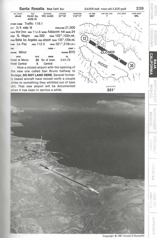
1987:


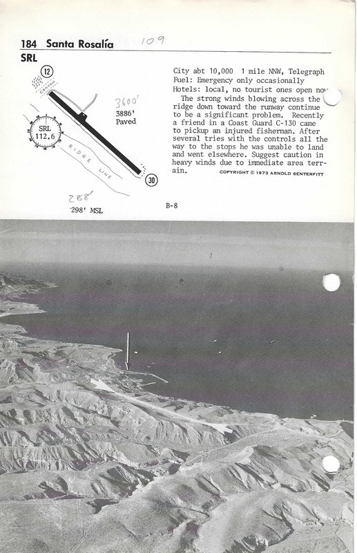
1973:


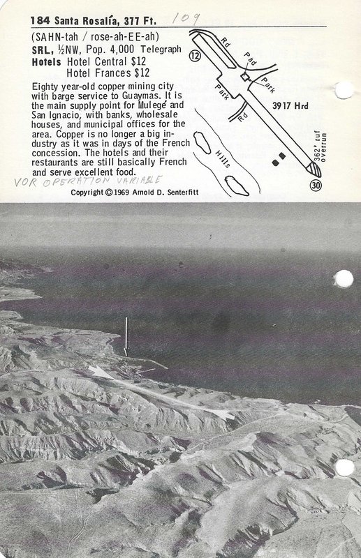
1969:

4x4abc - 4-15-2023 at 10:01 AM

after the houses were built

af.jpg - 269kB

KurtG - 4-16-2023 at 06:14 PM

Back in the 1970's AeroMexico flew into that strip from Guaymas using the Twin Otter. I flew out of there once in '75. It was a little exciting in a heavily loaded airplane.

David K - 4-16-2023 at 06:20 PM

Indeed, if you read about the crosswinds there... not safe! They had used the San Lucas Cove military strip (in the 1960s) for civilian flights, too, before building this one in town. The Palo Verde airport (called San Bruno by Arnold Senterfitt) replaced the Santa Rosalia one plus it was to serve Mulegé, too. In 2014, flash floods went over the runway leaving debris, and that was repeated in 2019, I think?

LancairDriver - 4-17-2023 at 09:57 AM

I sat out a nasty storm that forced us into that airport years ago with about 5 other airplanes squeezed in there also. We used passing airliners overhead to relay messages home to family’s who would be expecting arrivals. Those were the days of almost no telephones around Baja outside the bigger city’s. Myself and a friend were both single then and met two young lady’s who also flew in there from San Diego. We all decided to extend our trips when the storm permitted and flew up to B of LA for an extended vacation. Fun times.

JZ - 4-17-2023 at 11:13 AM

Quote: Originally posted by LancairDriver  
I sat out a nasty storm that forced us into that airport years ago with about 5 other airplanes squeezed in there also. We used passing airliners overhead to relay messages home to family’s who would be expecting arrivals. Those were the days of almost no telephones around Baja outside the bigger city’s. Myself and a friend were both single then and met two young lady’s who also flew in there from San Diego. We all decided to extend our trips when the storm permitted and flew up to B of LA for an extended vacation. Fun times.


I want to see some trip photos.


Salsa - 5-18-2023 at 09:08 AM

Harry Merrick's book "Baja Traveler" published in 1974 has a lot of aerial pictures. Most of then show location, but not many closeup.

Don

David K - 5-18-2023 at 09:48 AM

Quote: Originally posted by Salsa  
Harry Merrick's book "Baja Traveler" published in 1974 has a lot of aerial pictures. Most of then show location, but not many closeup.

Don


1988:


[The paved strip above town is reported closed with an alternate, dirt strip, along the beach mentioned. It's south end is where Hwy. 1 comes to the coast from San Ignacio. In Arnold Senterfitt's 1994 edition, he calls that strip 'Playa María', says it is 4,160 ft. long, packed & graded.]
--------------------------------------------------------------------------------------------------------------------------------

1974:


4x4abc - 5-18-2023 at 10:10 AM

good find!