BajaNomad

Bahia de Los Angeles,, must see's, etc?

micah202 - 1-16-2020 at 02:32 AM

Can't believe it,, I've been hitting Baja since the 80's,, haven't been to BOLA yet.
....What are the highlights, must see's, best places to eat, and recommended boondocking sites by the sea?
La Gringa is the place to be?

Fuel is reliable in BOLA?

Cave paintings,,, I know guides are required, what's the $ and time budget for a good excursion,, and who are recommended guides, where to find them?

And what of the possibility of whale excursions out of BOLA? I know of course GN and Ignacio are more sure for that, but also there's other whales to see in Cortez, but are the prospects of sewing a whale actually worth
it on the Cortez side?

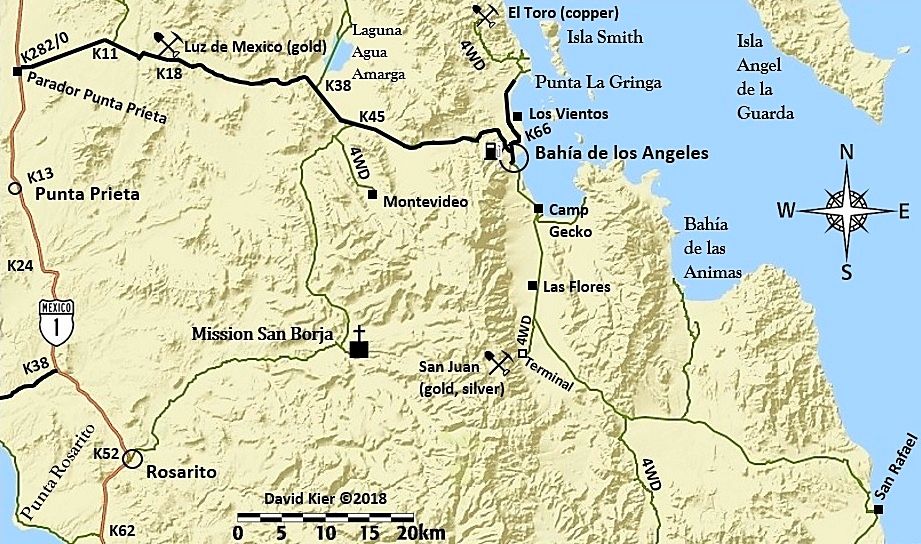
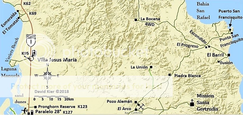
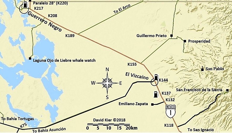
What about the road out to the south? ....BOLA- Bahia San Rafael-Rancho Piedra Blanca-'hwy18', out to Guerro Negro... Suitable for a raised Toyota Sienna, truck tires, with seasoned driver? Is there a reasonable amount of traffic, 5-10/day, 'just in case' we get stuck? How many driving hours to get out that way to Guerro Negro?

Mucho Gracias for any suggestions, ideas. <;~]


[Edited on 1-16-2020 by micah202]

NE14Baja - 1-16-2020 at 08:36 AM

Look up Ricardo Arce in BOLA, he runs a dive company there.
He will also take you on tours of the bay and islands, you will likely see an abundance of see creatures while on your tour. Blue whales, fin whales, whale sharks, dolphins, sea turtles and fish boils were all seen while on our tour.
You can look him up on the net and read reviews and get info.
Boon docking available at LA Gringa, camping at Archelon or Daggets.
Side trip to the mission in San Borja is nice. Museum in town is cool too.


wilderone - 1-16-2020 at 09:16 AM

Get out to Animas Bay; look for the indigenous stone walls west there (lots of info on this forum). I kayaked and camped on Isla La Ventana and Isla Coronado - no fish for snorkeling. A little hiking on Isla Coronado. Are you camping? I did not like Daggetts for camping - too many cars and quads coming past kicking up the dust; gringos with their dogs running loose on the beach. La Gringa might be more peaceful. Hang out at the old "Docs" south of town, and ask if the whale sharks have been spotted. Camped there once, and feeding dolphins came every morning about10 yards off shore. Take the back road to San Borja mission - ask the caretaker family as a guide. Ask if they will allow you to use the warm springs (it's private property). Interesting hiking around there. En route to San Borja on that road there are some geoglyphs - keep an eye out for them (they cross the road, or rather, the road goes right through).

micah202 - 1-16-2020 at 09:20 AM


just got a U2U,,, reminded me of the beautiful adventure which is Baja...
Quote:
Hola, we’re heading to Las Animas on the 1-21 crossing in Mexicali.
If you down during that time frame maybe we can keep an eye out for you on the dirt road south of BOLA


That's the great thing about Baja, we all keep an eye out for each other!

I remember back in the early 80's, the 'peurtecitos highway' was a sign, and a terrifyingly long dirt road. I got totally stuck at one point, hadn't seen a car all day,,, but some locals appeared within 5 minutes,, wouldn't accept any 'gratitudes' for their help!

micah202 - 1-16-2020 at 09:37 AM

Nice suggestions folks, keep 'em coming! The title will long serve as a useful search for others.

I camp from my Sienna, bring kayak and small sailboat on the roof. I'm immediately drawn to la Gringa for the excellent wave protection from the Norte winds.
...that'd be way cool to spend time on the islands, we'll see.

Nice details in your posts folks,,, Whale sharks would be amazing!
...and Hot Springs too!? I'll add it to an old thread I started... 'the Hot Springs ' thread.

...any further leads on San Borja? ..km's to south? Not finding anything..... and Animas Bay? I see Animas Ecolodge to the south, I'm guessing that's the place for some picto's you mention.

Quote: Originally posted by wilderone  
Get out to Animas Bay; look for the indigenous stone walls west there (lots of info on this forum).

I kayaked and camped on Isla La Ventana and Isla Coronado - no fish for snorkeling. A little hiking on Isla Coronado.

Are you camping? I did not like Daggetts for camping - too many cars and quads coming past kicking up the dust; gringos with their dogs running loose on the beach. La Gringa might be more peaceful. Hang out at the old "Docs" south of town, and ask if the whale sharks have been spotted. Camped there once, and feeding dolphins came every morning about10 yards off shore.

......Take the back road to San Borja mission - ask the caretaker family as a guide. Ask if they will allow you to use the warm springs (it's private property). Interesting hiking around there.

...... En route to San Borja on that road there are some geoglyphs - keep an eye out for them (they cross the road, or rather, the road goes right through).


[Edited on 1-16-2020 by micah202]

JZ - 1-16-2020 at 10:20 AM

Suggestions:

- day trip or camp at Ensenada Alcatraz. 29.161269° -113.613994°. Go out towards MX1 about 20 miles then up the dry lake bed, then West to the coast. Beautiful beach up there. I'll post a track later. Easy drive with a truck.

- day trip or camping at Bahia las Animas. Or stop there for a day/night on the way to San Fransquito

- rent a super panga and spend a night or two in the bay at the top of Isla Ángel de la Guarda at Puerto Refugio. The most beautiful bay in the Sea of Cortez. Watch this video to see it: https://youtu.be/g3ThXCm3XSA

- rent a panga (2500 pesos) and go explore the islands in the bay and go over to Rincon. Rincon is the best beach in Bahia de los Angeles by a very wide margin. Beautiful white sand. 28.913807° -113.471214°.

- La Gringa has some rocky beaches. We've found better beaches just before the pavement ends on the way out to La Gringa. Just after all the sprawl on the beach stops. I think you could camp there. We go there to hang out at night for a few hours sometimes. You can drive the entire length of the beach once you get down to the water.

We always make a fire on the beach. The market on the West side of the main drag has tons of firewood. A whole pile out back.


micah202 - 1-16-2020 at 10:28 AM

Nice deets with co-ordinates!

Animas is the first bay south of BOLA bay?

Where's the Panga rental, or is it pretty obvious?
Is a panga different than a 'super' panga?

All these things to do and see,,,,, how's the groceries, ice in BOLA,, pretty well stocked for 800peops, no need to provision elsewhere??


Quote: Originally posted by JZ  
Suggestions:

- day trip or camp at Ensenada Alcatraz. 29.161269° -113.613994°. Go out towards MX1 about 20 miles then up the dry lake bed, then West to the coast. Beautiful beach up there. I'll post a track later. Easy drive with a truck.

- day trip or camping at Bahia las Animas. Or stop there for a day/night on the way to San Fransquito

- rent a super panga and spend a night or two in the bay at the top of Isla Ángel de la Guarda at Puerto Refugio. The most beautiful bay in the Sea of Cortez. Watch this video to see it: https://youtu.be/g3ThXCm3XSA

- rent a panga (2500 pesos) and go explore the islands in the bay and go over to Rincon. Rincon is the best beach in Bahia de los Angeles by a very wide margin. Beautiful white sand. 28.913807° -113.471214°.

- La Gringa has some rocky beaches. We've found better beaches just before the pavement ends on the way out to La Gringa. Just after all the sprawl on the beach stops. I think you could camp there. We go there to hang out at night for a few hours sometimes. You can drive the entire length of the beach once you get down to the water.

We always make a fire on the beach. The market on the West side of the main drag has tons of firewood. A whole pile out back.


[Edited on 1-16-2020 by micah202]

Everything you seek is here on Nomad...

David K - 1-16-2020 at 10:45 AM

My trip reports from researching for the road guide are from 2017 and 2018, but still can give you lot's a details:

In fact, I have shared my Road guide Part 3 which covers L.A. Bay and San Borja, here on Nomad: http://forums.bajanomad.com/viewthread.php?tid=91898

These trip reports cover L.A. Bay, San Borja, the road down and out via El Arco (Hwy. 18)...
Trip Report 1: http://forums.bajanomad.com/viewthread.php?tid=85374
Trip Report 2: http://forums.bajanomad.com/viewthread.php?tid=85756
Trip Report 5: http://forums.bajanomad.com/viewthread.php?tid=86781

All my maps are here: http://forums.bajanomad.com/viewthread.php?tid=88771

[Edited on 1-16-2020 by David K]

JZ - 1-16-2020 at 11:01 AM

Diaz has pretty cheap pangas. Great for running around in the bay. For the big super panga with a tower go to Guillermos. You can hike some of the islands. Especially this one: 28.999439° -113.513450°. At the top you can see the entire bay.

Both panga shops are right by the launch ramps near the Southwest side of town.

Bahia de Las Animas is here: 28.822618° -113.364675°.

I have tracks for all the various places.

micah202 - 1-16-2020 at 11:07 AM

Quote: Originally posted by JZ  
Diaz has pretty cheap pangas. Great for running around in the bay. For the big super panga with a tower go to Guillermos. You can hike some of the islands. Especially this one: 28.999439° -113.513450°. At the top you can see the entire bay.

Both panga shops are right by the launch ramps near the Southwest side of town.

Bahia de Las Animas is here: 28.822618° -113.364675°.

I have tracks for all the various places.


hummm, how to use the geo-co-ordinates? I tried google maps. :rolleyes:

micah202 - 1-16-2020 at 11:12 AM

hah, you answered my next question in here I bet. Certainly the request for a map. I had only seen the road going south from BOLA, past Camp Gecko and Las Flores,,, out to 1 south of Guerro Negro,,, that's more rugged I suppose?


Quote: Originally posted by David K  
My trip reports from researching for the road guide are from 2017 and 2018, but still can give you lot's a details:

In fact, I have shared my Road guide Part 3 which covers L.A. Bay and San Borja, here on Nomad: http://forums.bajanomad.com/viewthread.php?tid=91898

These trip reports cover L.A. Bay, San Borja, the road down and out via El Arco (Hwy. 18)...
Trip Report 1: http://forums.bajanomad.com/viewthread.php?tid=85374
Trip Report 2: http://forums.bajanomad.com/viewthread.php?tid=85756
Trip Report 5: http://forums.bajanomad.com/viewthread.php?tid=86781

All my maps are here: http://forums.bajanomad.com/viewthread.php?tid=88771

[Edited on 1-16-2020 by David K]

David K - 1-16-2020 at 11:16 AM

It is a 2WD graded highway from L.A. Bay south to Punta San Francisquito and then west to El Arco and Hwy. 1.


JZ - 1-16-2020 at 11:18 AM

Quote: Originally posted by micah202  

[/rquote]

hummm, how to use the geo-co-ordinates? I tried google maps. :rolleyes:


Install Google Earth Pro on to your computer (or phone/tablet). C/P the coordinates into the search.

You can use Google Earth online, I just like the Pro better.


JZ - 1-16-2020 at 11:23 AM

Some tips:

1. Install a GPS app on our phone.

Back Country Navigator is my favorite, but Android only. Gaia is great and works with all phones. This is a must have. When ppl give you tracks, you can down load them right to your phone or tablet. It's like Google Maps for dirt roads.

This works w/o having cell coverage as long as you download the maps ahead of time. Topo or Satellite views. Top requires MUCH less data and downloads very fast. Satellite view is awesome though.

Put it this way, I have what David just posted above on my phone in either Topo or Satellite versions. When we are driving it shows us on the map. Same for when out on the water. We can see what bays to hit.

2. Download Google Maps for offline use in Baja.

This allows you to use it w/o cell coverage. Great for the paved roads.


[Edited on 1-17-2020 by JZ]

micah202 - 1-16-2020 at 11:24 AM

ahh, so the markings of '4WD' are outdated?

Quote: Originally posted by David K  
It is a 2WD graded highway from L.A. Bay south to Punta San Francisquito and then west to El Arco and Hwy. 1.

micah202 - 1-16-2020 at 11:31 AM

When you say 'Pro tips' here,, are you relating it to GooglePro, in your post above? It seems to be 2 apps you're suggesting,, Google Pro, and Back Country Navigator?

Quote: Originally posted by JZ  
Pro tips:

1. Install a GPS app on our phone.

Back Country Navigator is my favorite, but Android only. Gaia is great and works with all phones. This is a must have. When ppl give you tracks, you can down load them right to your phone or tablet. It's like Google Maps for dirt roads.

This works w/o having cell coverage as long as you download the maps ahead of time. Topo or Satellite views. Top requires MUCH less data and downloads very fast. Satellite view is awesome though.

Put it this way, I have what David just posted above on my phone in either Topo or Satellite versions. When we are driving it shows us on the map. Seem for when out on the water. We can see what bays to hit.

2. Download Google Maps for offline use in Baja.

This allows you to use it w/o cell coverage. Great for the paved roads.


[Edited on 1-16-2020 by JZ]

JZ - 1-16-2020 at 11:36 AM

No.


micah202 - 1-16-2020 at 11:53 AM

...but Google Pro and GPS Navigator are 2 different app you're suggesting,,yes? :)

Quote: Originally posted by JZ  
No.


JZ - 1-16-2020 at 12:15 PM

Google Earth Pro - for use on your laptop. Allows you to study Baja on satellite images. Zoom in on dirt roads, check out bays and beaches. Plug in coordinates from ppl to see where it is. Add way points. Build your own tracks. Import tracks from others. Export tracks and waypoints to GPS phone apps (see below).

Back Country Navigator or Gaia - GPS apps for phones with either Topo or Satelite imagery. Allows you to record your own tracks. Or import tracks/waypoints you have made on Google Earth. Or import tracks you get from other ppl. Tracks are typically in KMZ or GPX format.

Google Maps - the app you use every day. It allows you to download maps for offline use (i.e. no cell service). You can download all of Baja. Great for when driving on the pavement.


micah202 - 1-16-2020 at 12:40 PM


Ahh, got it,thanks

[quote=1177684&tid=93888&author=JZ]Google Earth Pro - for use on your laptop. Allows you to study Baja on satellite images. Zoom in on dirt roads, check out bays and beaches. Plug in coordinates from ppl to see where it is. Add way points. Build your own tracks. Import tracks from others. Export tracks and waypoints to GPS phone apps (see below).

Back Country Navigator or Gaia - GPS apps for phones with either Topo or Satelite imagery. Allows you to record your own tracks. Or import tracks/waypoints you have made on Google Earth. Or import tracks you get from other ppl. Tracks are typically in KMZ or GPX format.

Google Maps - the app you use every day. It allows you to download maps for offline use (i.e. no cell service). You can download all of Baja. Great for when driving on the pavement.

[/rquote]

Alm - 1-16-2020 at 01:09 PM

Other than a small museum, there is pretty much nothing to see in the actual town of BOLA. Daytrips within one-two hour drive - yes, possibly.

The best low-key camp is definitely Archelon. You'll be on the beach, with hot showers, toilets and even a small cafeteria (recent addition by Tony junior, son of late Antonio Resendiz). You can safely leave your car and take a sunset stroll to the lighthouse, and your garbage will go where it should.

Rent a panga to Isla de La Guarda if you can and/or if the weather is predictably stable for the day. Otherwise, Isla Smith has similarly nice coves and is much closer.

Groceries are "available". There might not be fresh meat or fruits or dairy on some days but there will be basic stuff. I don't know what 800peops is.

Gas is "usually available".

Dining out - I would say, Alejandrina restaurant. Though, nothing to write home about.

Whale watching is better done from GN. In BOLA you may or may not see them on the exact day that you plan.

David K - 1-16-2020 at 01:25 PM

Quote: Originally posted by micah202  
ahh, so the markings of '4WD' are outdated?

Quote: Originally posted by David K  
It is a 2WD graded highway from L.A. Bay south to Punta San Francisquito and then west to El Arco and Hwy. 1.


No, the first 4WD notation is for the side road to the terminal platform below the San Juan Mine tramline end at the Las Flores Railroad line. See my trip report.
The second 4WD notation is for the old road along the sierra. The graded dirt highway goes via San Rafael.

[Edited on 1-16-2020 by David K]

wilderone - 1-16-2020 at 02:32 PM

yeah, 800peops? Everything in BOLA is more expensive, and not much choice. Large grocery stores in Ensenada; pick up tortillas, empanadas, ice and beer in El Rosario. Also, the family at San Borja has a nice garden area, as does their closest neighbor. I bring them vegetable seeds - it's a long way to a grocery store for them.

David K - 1-16-2020 at 02:45 PM

Micah202, back when I made my website www.vivabaja.com it was to help people decide what to visit based on what they liked to see or do. I provided links to other sites, other Nomad's photos, my trip photos, maps, etc.
I made a 'self-guided' tour page that took you to my photos at various regions in Baja. Now, that was over 10-15 years ago, and I have newer photos of many of these sites... but this is what I had for the L.A. Bay region: This is the link: http://vivabaja.com/tours/index.html

Bahia de los Angeles Area

Tinaja de Yubay
Punta Candeleros & Remedios (Bahia Guadalupe)
El Toro Copper Mine
Camp Gecko cabin, turtle research station, & La Gringa
Bahia de los Angeles highway, Pemex, etc. '05
Bahia de los Angeles Museum
Mision San Borja
Mision San Borja (inside)
Old San Gregorio
Santa Ana, San Ignacito
Montevideo Petroglyphs
Las Tinajitas Petroglyphs
Camp Gecko '03
Las Flores
Los Paredones, La Bocana, Bahia San Rafeal
Las Flores Railroad and Tramway
Rock Palm Hill (near Yubay)
Bahia las Animas
Punta La Gringa
Mysterious Ruins/ Lost Mission Site?

micah202 - 1-16-2020 at 03:21 PM

ALM... that's a very useful note on the groceries. I picture it being similar to Gonzaga that way.
.....Whale watching,,, diversity, but not a sure thing,, similar impression i had for whale tours from Loreto.
.... I usually get some good marine interactions from my boats I bring along,, was sailing with the whales in GN last time. Would love a whaleshark encounter sometime.

Quote: Originally posted by David K  
Quote: Originally posted by micah202  
ahh, so the markings of '4WD' are outdated?

Quote: Originally posted by David K  
It is a 2WD graded highway from L.A. Bay south to Punta San Francisquito and then west to El Arco and Hwy. 1.


No, the first 4WD notation is for the side road to the terminal platform below the San Juan Mine tramline end at the Las Flores Railroad line. See my trip report.
The second 4WD notation is for the old road along the sierra. The graded dirt highway goes via San Rafael.

[Edited on 1-16-2020 by David K]


Nice to know of the two backroad options and that they're both reasonably accessible, though the San Borja hotspring,picto's and somewhat shorter route back to #1 is tipping the scale.

David K - 1-16-2020 at 04:59 PM

San Borja is a must see... Palapa camping there with flush toilets and showers. José and his family are excellent hosts. He will light a fire under the water heater so it will be hot showers for you!

The north road is very good with only a few rough miles. The west road (out to Nuevo Rosarito) is less maintained so a bit slower. José can be hired (or his son) to take you to Las Tinajitas or perhaps another rock art site? Plan to spend a day or more to get in the mission and the other attractions. Yes, the warm spring can be bathed in... I haven't, as the sulfur smell is a bit foul sometimes.


Las Tinajitas


mtgoat666 - 1-16-2020 at 06:10 PM

Quote: Originally posted by micah202  
Nice suggestions folks, keep 'em coming! The title will long serve as a useful search for others.

I camp from my Sienna, bring kayak and small sailboat on the roof. I'm immediately drawn to la Gringa for the excellent wave protection from the Norte winds.
...that'd be way cool to spend time on the islands, we'll see.


What type of kayak and sailboat?
If you got good equip (sea kayak or good daysailer) and skills, go to the nearest islands. Isla Smith is a good trip. The peninsula north of las animas (SE of town) is good paddle. Be careful of venturing offshore or rocky coastline if your experience level is low.

JZ - 1-16-2020 at 06:46 PM

Market level is definitely a good step above Gonzaga. There are 3 markets. Never bought steak in BoLA, but they have pretty much everything you could need. Saving a few bones in Ensenada isn't worth having to cart all that stuff down.

Anyway, it's fun going to the local markets and meeting the folks.


Pic from the beach just before the pavement ends on the way to La Gringa:


[Edited on 1-17-2020 by JZ]

advrider - 1-16-2020 at 07:05 PM

All awesome suggestions by the regulars! I would add that I like OSM app for Baja navigation, easy to use. I've always wanted to climb/hike Mikes mountain, South/West end of BOLA. Campo Archelon is a good camp spot. Costa Del Sol and China's taco stand are always a good bet for a meal. Always wanted to explore out past La Gringa as well. Good luck and please post a report.

Alm - 1-17-2020 at 02:13 PM

With your kayaking/sailing plans you'd better print tide tables for that time-frame: http://redmar.cicese.mx/meteoro/graph/calendario_tablas.php - change the date and town in the dropdown menu.

In BOLA when tide is coming, current flows North and can be strong around the points and narrow passages. When tide is going the current flows South. Simple.

The heaviest winds are from North and West. Southerly and Easterly winds are rarely heavy.

You don't want to deal with both headwind and opposing current. Especially in a kayak. In a sailboat it also sucks, and probably sucks even more when you are 10 miles from home, wind suddenly dies (could happen late afternoon), and there is opposing current.

[Edited on 1-17-2020 by Alm]

micah202 - 1-17-2020 at 02:20 PM

Thanks All, good details to note in general.
As for myself, I have a long background in both Olympic sailing and visiting Baja in this way.
If you see a small sailboat out in 30+ knots of breeze, that'll likely be me! :light:

motoged - 1-18-2020 at 11:14 AM

Quote: Originally posted by JZ  
... Never bought steak in BoLA, ...


[Edited on 1-17-2020 by JZ]


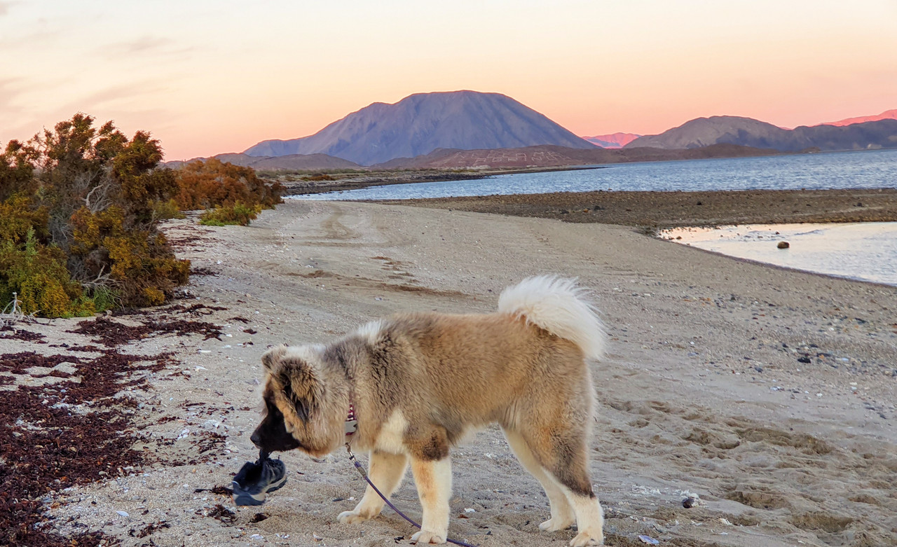
Who needs a steak when you can chew on a stinky running shoe :biggrin:

Alm - 1-18-2020 at 12:40 PM

About steak etc - I would not carry perishables from Ensenada or Tijuana to BOLA without adequate refrigeration arrangements in the vehicle. But I would bring everything else and also long-lasting food items from the States like cooking oil, nuts, your favorite herbal teas, good quality rice and beans etc. In BOLA it will cost double, if at all available. Rice will be sh-tty, beans - with small rocks.

There is also this 3-rd world habit in small villages - no price tags on anything, makes you suspect the worst (and it usually is).

[Edited on 1-18-2020 by Alm]

David K - 1-18-2020 at 01:58 PM

What's wrong with bringing an ice chest?
L.A. Bay is only 8 hours from the border, not 8 days.
Seriously though, instead of steak, why not fresh, local seafood instead?
Viva Baja Food!

JZ - 1-18-2020 at 02:46 PM

Quote: Originally posted by Alm  
About steak etc - I would not carry perishables from Ensenada or Tijuana to BOLA without adequate refrigeration arrangements in the vehicle. But I would bring everything else and also long-lasting food items from the States like cooking oil, nuts, your favorite herbal teas, good quality rice and beans etc. In BOLA it will cost double, if at all available. Rice will be sh-tty, beans - with small rocks.

There is also this 3-rd world habit in small villages - no price tags on anything, makes you suspect the worst (and it usually is).

[Edited on 1-18-2020 by Alm]


Disagree strongly with all this.

Don Pisto - 1-18-2020 at 05:14 PM

Quote: Originally posted by Alm  
About steak etc - I would not carry perishables from Ensenada or Tijuana to BOLA without adequate refrigeration arrangements in the vehicle. But I would bring everything else and also long-lasting food items from the States like cooking oil, nuts, your favorite herbal teas, good quality rice and beans etc. In BOLA it will cost double, if at all available. Rice will be sh-tty, beans - with small rocks.

There is also this 3-rd world habit in small villages - no price tags on anything, makes you suspect the worst (and it usually is).

[Edited on 1-18-2020 by Alm]


:lol: oh good lord.......

Alm - 1-18-2020 at 05:54 PM

Quote: Originally posted by JZ  

Disagree strongly with all this.

If you disagree that BOLA prices are much higher than Tijuana or Ensenada and don't see anything wrong with BOLA products, then you can't count and have sense of taste strongly diminished. No offense :)

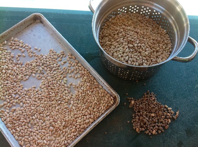
I tried beans in unmarked bags from the Isla, - small rocks in there. Some light-brown beans, forget red kidney beans, they don't know what that is. Tried another kind in a sealed branded bag from Mike's store - same rocks. OTH, olive oil was nice, imported Spanish, cost 2 times of what you pay in Safeway. And so on, etcetera, etcetera.

Alm - 1-18-2020 at 06:01 PM

Quote: Originally posted by David K  

Seriously though, instead of steak, why not fresh, local seafood instead?

There is fish, shrimp and scallops. Usually frozen, not fresh. You'll have to ask locals for this, stores don't sell any. Really pathetic stores.

micah202 - 1-18-2020 at 07:04 PM

I agree with the suggestion of bringing a base stock of things from home,, the favorites,, condiments,, usually found at home.
Personally, I'd never travel without my favorite granola for camp mornings. <;~0

I'm not big enough on steak to be concerned, but certainly an extra insulated cooler covers that for a few days,.

Local fish is a favorite,, best bought straight from the panga's as they hit the beach. That's what I love of Baja, fish camps all over the place, even in pretty isolated boondocking sites,, pretty rare to buy that in any shops!

I usually take a good load of fish and prawns home to Vancouver with me....just don't forget to add ice each couple of days.

In general, a decent cooler allows for 3-4 days remote camping before re-stock,, just eat the more perishable items first.

mtgoat666 - 1-18-2020 at 07:04 PM

Quote: Originally posted by Alm  
Rice will be sh-tty, beans - with small rocks.


You be a dumb flock that don’t know how to prepare beans.
You should stay in usa and eat microwaved TV dinners.

4x4abc - 1-18-2020 at 07:06 PM

Quote: Originally posted by wilderone  
En route to San Borja on that road there are some geoglyphs - keep an eye out for them (they cross the road, or rather, the road goes right through).

where where where?
lat/long?

JZ - 1-18-2020 at 07:24 PM

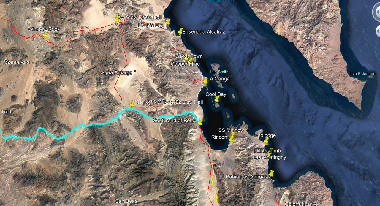
Here you go OP. A bunch of waypoints and tracks around BoLA. The file will load directly into Google Earth.


Attachment: Area Around BoLA.kmz (38kB)
This file has been downloaded 175 times

[Edited on 1-19-2020 by JZ]

micah202 - 1-18-2020 at 08:14 PM

Very nice,, though I'm wondering about the red lines,, your moto-tracks,, or doable in a raised minivan?

Quote: Originally posted by JZ  
Here you go OP. A bunch of waypoints and tracks around BoLA. The file will load directly into Google Earth.


[Edited on 1-19-2020 by JZ]

JZ - 1-18-2020 at 08:26 PM

Sorry, I need to start color coding better.

Red trail up from MX 12 (paved road into BoLA from MX 1) up through the lake bed and then East to Ensenada Alactraz is easy in a truck. That's the Window Rock trail (goes from MX 1 to the coast).

Going West on WR trail to MX 1 from the lake bed turn off is single track.

And going straight down South from Alactraz to La Gringa is single track or maybe a big time jeep - that's the red/white track.

All the rest of the red is fine for a truck, e.g. the places South of BoLA.


[Edited on 1-19-2020 by JZ]

micah202 - 1-18-2020 at 08:41 PM

I'm the first toadmit I'm a simpleton with computers,, but I can't for the life of me get your map link to open anywhere,,, GoogleEarthPro is installed.

Attachment: Area Around BoLA.kmz (38kB).... shows some gibberish of Nomad when I cut paste it,, and clicky is no better. :?:

Quote: Originally posted by JZ  
Here you go OP. A bunch of waypoints and tracks around BoLA. The file will load directly into Google Earth.


[Edited on 1-19-2020 by micah202]

4x4abc - 1-18-2020 at 11:05 PM

download the kmz file
you may want to create a dedicated folder for this, because you might get a lot of trip/location recommendations for Baja
open GoogleEarth
from the file menu select "Open..." and chose the downloaded kmz file
done

micah202 - 1-19-2020 at 12:24 AM

Dang,, I'm finding google earth really bogs down my data. The tablet just doesnt have enough gigs,, have to delete almost everything else, and the desktop freezes.
So far, I've been finding 'Open street view, shows up back country roads the best, plus there's commentary added. IOverlander is similar.
For satelite view, I jump over to Google maps.
Google earth just stops ....everything. :no:

Quote: Originally posted by 4x4abc  
download the kmz file
you may want to create a dedicated folder for this, because you might get a lot of trip/location recommendations for Baja
open GoogleEarth
from the file menu select "Open..." and chose the downloaded kmz file
done

wilderone - 1-19-2020 at 07:39 AM

Re Geoglyphs on the San Borja backroad. I don't know location exactly. If you've been on that road, you know it goes through a lot of rocky stuff, goes up and down and curves through some canyons. When you get to a mesa, or flatter terrain - maybe about 11-15 mi. from San Borja, is where they would logically be. You'll at first think they're cattle tracks, but there aren't cattle tracks elsewhere like that. Also, they're too narrow for cattle tracks and no hoofprints around, and not deep enough as would indicate continued use with cattle.

PS: Takes a LOT of fuel, and soak overnight to make some bland beans on a camping trip. Who does that. Can of refried black beans will do it for me. Dehydrated split pea and black bean soup from Whole Foods. Great with a quesadilla.

David K - 1-19-2020 at 08:03 AM

Just so there is no confusion, "Mexico Hwy. 12" is only on Google or Internet Maps. In reality, it has always (since 1974 when they began paving it) been part of Mexico Hwy. 1. IF anyone sees a Mexico #12 sign down there on that road, please take a photo and post it!

David K - 1-19-2020 at 08:43 AM

Quote: Originally posted by wilderone  
Re Geoglyphs on the San Borja backroad. I don't know location exactly. If you've been on that road, you know it goes through a lot of rocky stuff, goes up and down and curves through some canyons. When you get to a mesa, or flatter terrain - maybe about 11-15 mi. from San Borja, is where they would logically be. You'll at first think they're cattle tracks, but there aren't cattle tracks elsewhere like that. Also, they're too narrow for cattle tracks and no hoofprints around, and not deep enough as would indicate continued use with cattle.

PS: Takes a LOT of fuel, and soak overnight to make some bland beans on a camping trip. Who does that. Can of refried black beans will do it for me. Dehydrated split pea and black bean soup from Whole Foods. Great with a quesadilla.


Do you think you are seeing a section of El Camino Real, rather than a geoglyph?

The Jesuits built their road in straight sections where ever the terrain permitted. Since they were removed less than 6 years after founding that mission and only had begun the next mission at Calamajué a year before their removal, we generally don't see typical Jesuit roads north of San Borja, just smaller trails, like cattle trails.

This map shows the road (blue) and El Camino Real (yellow) from the L.A. Bay highway south to Mission San Borja:


4x4abc - 1-19-2020 at 11:01 AM

Quote: Originally posted by micah202  
Dang,, I'm finding google earth really bogs down my data. The tablet just doesnt have enough gigs,, have to delete almost everything else, and the desktop freezes.
So far, I've been finding 'Open street view, shows up back country roads the best, plus there's commentary added. IOverlander is similar.
For satelite view, I jump over to Google maps.
Google earth just stops ....everything. :no:


are you using the web version of Google Earth or the standalone app?

4x4abc - 1-19-2020 at 11:24 AM

Quote: Originally posted by wilderone  
Re Geoglyphs on the San Borja backroad. I don't know location exactly. If you've been on that road, you know it goes through a lot of rocky stuff, goes up and down and curves through some canyons. When you get to a mesa, or flatter terrain - maybe about 11-15 mi. from San Borja, is where they would logically be. You'll at first think they're cattle tracks, but there aren't cattle tracks elsewhere like that. Also, they're too narrow for cattle tracks and no hoofprints around, and not deep enough as would indicate continued use with cattle.

PS: Takes a LOT of fuel, and soak overnight to make some bland beans on a camping trip. Who does that. Can of refried black beans will do it for me. Dehydrated split pea and black bean soup from Whole Foods. Great with a quesadilla.


north or west of San Borja?

micah202 - 1-19-2020 at 11:47 AM

...stand alone on the desktop,, tried the app on the tablet. <;~l


Quote: Originally posted by 4x4abc  
Quote: Originally posted by micah202  
Dang,, I'm finding google earth really bogs down my data. The tablet just doesnt have enough gigs,, have to delete almost everything else, and the desktop freezes.
So far, I've been finding 'Open street view, shows up back country roads the best, plus there's commentary added. IOverlander is similar.
For satelite view, I jump over to Google maps.
Google earth just stops ....everything. :no:


are you using the web version of Google Earth or the standalone app?

Alm - 1-19-2020 at 12:01 PM

Quote: Originally posted by lencho  
A traditional step in cooking Mexican beans is cleaning them before they go into the pot; nothing particular to L.A. Bay.

I think this may be a result of sourcing closer to the fields than in the U.S... :?:

Washed, rocks picked out, beans soaked overnight. Some rocks are still there when you eat it. A Mexican sitting and sorting it a few times would've resolved the problem ;).

Sourcing closer to the fields... This would be the case with unmarked bags, but they were not too clean in sealed branded bags either. it's a generally low standard of the industry. Haven't had that much dirt in the US-packed beans.

Ah, yes - rice - don't buy the one in unmarked bags either. Clear grocery bags tied in a knot, not sealed. Low grade rice with lot of fine particulate matter, you rinse it several times and it's still foaming when cooking. Buy rice in branded bags - more expensive, but better. Or bring from the US the brand that you trust. High pesticides load in non-organic rice is a concern too, I would imagine this situation being worse than North of the border.

Groceries in this little town are delivered once a week. 2 days later and until the next delivery you get beef with brown stains of decay after being kept in store fridge above 50F, rotten bananas and tomatoes (or none at all), and other pleasantries. Locals are traveling to Enesanda and GN often, and bring everything they can from there.

micah202 - 1-19-2020 at 12:17 PM

Hmmm,, sounds like they could use a coupla family farms in there. Or even more regular deliveries.

Think of all the fuel burnt if each family is doing regular veg runs to ensenada. We -have- to start thinking of these things. <;~l

David K - 1-19-2020 at 12:37 PM

The markets in L.A. Bay are not that sparsely stocked. Maybe chat with the Americans that live there if you need fresh produce to learn what day(s) of the week new inventory arrives or if there is a produce vendor that comes one day.

JZ - 1-19-2020 at 02:09 PM

Here is an updated KMZ. Added the track into San Borja and also a track to a really nice beach at Ensenada Alcatraz.


Attachment: Area Around BoLA.kmz (41kB)
This file has been downloaded 154 times


[Edited on 1-19-2020 by JZ]

JZ - 1-19-2020 at 02:11 PM

Quote: Originally posted by micah202  
Hmmm,, sounds like they could use a coupla family farms in there. Or even more regular deliveries.

Think of all the fuel burnt if each family is doing regular veg runs to ensenada. We -have- to start thinking of these things. <;~l


Ignore him. He's trying to save $20 by buying in bulk in Ensenada and/or hasn't been in a BoLA market in years.


[Edited on 1-19-2020 by JZ]

Paulina - 1-19-2020 at 03:22 PM

One might think that some of the posters to this thread haven't shopped in Bahia since the 80s. Most of the markets in town have Ensenada Costco products available. There is good beef and chicken available. Sometimes you have to ask if you don't see what you want. Fresh produce comes in on Friday. You can expect the stores to have it out for sale on Saturday mornings. Fresh baked goods are available too. Tortillas show up twice a week, no need to stop in Ensenada for them. If you want tri-tip or Prime cuts of beef, bring it with you. I'm not a picky eater but I have yet to find the stores lacking. Shop local and support the economy. You won't go hungry.

P>*)))>{

del mar - 1-19-2020 at 03:39 PM

Quote: Originally posted by Paulina  
One might think that some of the posters to this thread haven't shopped in Bahia since the 80s. Most of the markets in town have Ensenada Costco products available. There is good beef and chicken available. Sometimes you have to ask if you don't see what you want. Fresh produce comes in on Friday. You can expect the stores to have it out for sale on Saturday mornings. Fresh baked goods are available too. Tortillas show up twice a week, no need to stop in Ensenada for them. If you want tri-tip or Prime cuts of beef, bring it with you. I'm not a picky eater but I have yet to find the stores lacking. Shop local and support the economy. You won't go hungry.

P>*)))>{


so its not a steakless outpost where they put rocks in your beans and try to kill you with their rice?:lol:

micah202 - 1-19-2020 at 04:00 PM

Ah perfect,, thanks Paulina

Nothing like the voice of the one who actually shops, rather than a buncha (has)bean cooking prognosticators. :biggrin:

OCEANUS - 1-19-2020 at 04:04 PM

I agree with Paulina and others on this thread.

The markets in LA Bay are just fine, and have even increased in size and are stocked better than ever.

Keep in mind that many people (Baja travelers) appreciate that these markets are small, family-owned ventures that serve the community as opposed to the corporate mega-stores that dominate the U.S.

The "gripes" on this thread really do come across as outdated, Ugly American "sour grapes."

[Edited on 1-19-2020 by OCEANUS]

Paulina - 1-19-2020 at 05:59 PM


Sorting rocks and beans is a baja pastime that some of us don't mind doing ourselves. It's part of the package deal of living the good life.

P>*)))>{

bkbend - 1-19-2020 at 06:19 PM

P> has it. I couldn't find bananas on Friday, they were there and in great shape today. One thing to add, if you can't find something, try another store. It's routine to visit 2 or 3 markets to fill out the grocery list.

David K - 1-19-2020 at 06:29 PM

Can you L.A. Bay homeowners name the markets you guys use and which market for what, now? I recall there was one prefered for produce and another for meat, etc.
Is Xitlali, at the end of the pavement, still the biggest market?

mtgoat666 - 1-19-2020 at 07:39 PM

Quote: Originally posted by David K  
Can you L.A. Bay homeowners name the markets you guys use and which market for what, now? I recall there was one prefered for produce and another for meat, etc.
Is Xitlali, at the end of the pavement, still the biggest market?


Dk, you don’t need names of markets. The town is Very small. So small that You or anyone else can figure it out on your own when you get there, it’s not rocket science...

mtgoat666 - 1-19-2020 at 07:44 PM

Quote: Originally posted by Alm  
Quote: Originally posted by lencho  
A traditional step in cooking Mexican beans is cleaning them before they go into the pot; nothing particular to L.A. Bay.

I think this may be a result of sourcing closer to the fields than in the U.S... :?:

Washed, rocks picked out, beans soaked overnight. Some rocks are still there when you eat it. A Mexican sitting and sorting it a few times would've resolved the problem

Sourcing closer to the fields... This would be the case with unmarked bags, but they were not too clean in sealed branded bags either. it's a generally low standard of the industry. Haven't had that much dirt in the US-packed beans.


No one in bola has any teeth. They all lost their teeth eating beans with rocks :lol::lol:

Alm, why are you so focused on beans?

David K - 1-19-2020 at 09:32 PM

Quote: Originally posted by mtgoat666  
Quote: Originally posted by David K  
Can you L.A. Bay homeowners name the markets you guys use and which market for what, now? I recall there was one prefered for produce and another for meat, etc.
Is Xitlali, at the end of the pavement, still the biggest market?


Dk, you don’t need names of markets. The town is Very small. So small that You or anyone else can figure it out on your own when you get there, it’s not rocket science...


You may be against helping others, but I enjoy it. Locals will know which of the 3-5 markets has the best products. No need for Nomads to have to learn by trial and error where to get what and when.

L.A. Bay Nomads: If you want to remain anonymous, you may u2u me your recommendations and I will post what the answers are without saying who provided them. In addition, I have Facebook friends that have homes there but don't post on Nomad that I can ask.
Thank you.

JZ - 1-19-2020 at 09:39 PM

We always start at the one at the South end of town. They have a ton of stuff.

28.945923° -113.560044°


bkbend - 1-20-2020 at 06:40 AM

I start from the north and go south. Selection and quality varies day to day, no best store.

advrider - 1-20-2020 at 09:15 AM

We have camped there several times and always found what we needed in one form or another. They might not have the exact item but one that will work. I always like wondering around the little stores in towns just to see what they have, never know what you will find! Part of the adventure.

David K - 1-20-2020 at 09:23 AM

From u2u (so far), I read that the Isla and Montezuma stores are preferred and Dos Pinos and Xitlali stores are not so much.

Please u2u me if you are a regular shopper in L.A. Bay with a store opinion and want to remain anonymous.

Mr. Bills - 1-20-2020 at 10:28 AM

The request for names of grocery stores made me smile.

Recently, in another small town on the Pacific coast, a friend of mine asked if there was a place to buy fishing tackle. The universal answer was "la tienda azul." When asked for the name of the store no one knew - neither expats nor locals. It had apparently always been known simply as the blue store.

Imagine the confusion if that store is ever painted another color. Would it become "La tienda que antes era azul?" ;)


micah202 - 1-20-2020 at 10:49 AM

Quote: Originally posted by David K  
Can you L.A. Bay homeowners name the markets you guys use and which market for what, now? I recall there was one prefered for produce and another for meat, etc.
Is Xitlali, at the end of the pavement, still the biggest market?


Time to take it elsewhere.

Any boondocker far prefers the adventure of finding the treats of a town, rather than drooling over Cosco or some other mark of hell encroaching.

And really, I'm totally happy with the wide variety of tinned beans in any small town.;D

David K - 1-20-2020 at 11:20 AM

Quote: Originally posted by Mr. Bills  
The request for names of grocery stores made me smile.

Recently, in another small town on the Pacific coast, a friend of mine asked if there was a place to buy fishing tackle. The universal answer was "la tienda azul." When asked for the name of the store no one knew - neither expats nor locals. It had apparently always been known simply as the blue store.

Imagine the confusion if that store is ever painted another color. Would it become "La tienda que antes era azul?" ;)


Great story!
Near Colonet, in the mid 1970s, was a bakery, painted purple. So, naturally it was known as the Purple Panadería. Well, Tom Miller in his Baja Book and Mexico West newsletter wrote about it and apparently the business was just too much for the owner... as the next visit would reveal it had been repainted green!

BobbyC - 1-20-2020 at 12:43 PM

Campo Archelon

https://www.facebook.com/campoarchelon/

JZ - 1-20-2020 at 01:50 PM

Quote: Originally posted by David K  
From u2u (so far), I read that the Isla and Montezuma stores are preferred and Dos Pinos and Xitlali stores are not so much.

Please u2u me if you are a regular shopper in L.A. Bay with a store opinion and want to remain anonymous.


Don't like this approach to info. If someone has something to say, they need to get on the forum and present it and defend it.

I disagree with what you posted, and there is no one to discuss it with. Xitlati is very good.


JZ - 1-20-2020 at 01:52 PM

Quote: Originally posted by micah202  


Any boondocker far prefers the adventure of finding the treats of a town, rather than drooling over Cosco or some other mark of hell encroaching.

And really, I'm totally happy with the wide variety of tinned beans in any small town.;D


Agree 100%.

David K - 1-20-2020 at 02:08 PM

Quote: Originally posted by JZ  
Quote: Originally posted by David K  
From u2u (so far), I read that the Isla and Montezuma stores are preferred and Dos Pinos and Xitlali stores are not so much.

Please u2u me if you are a regular shopper in L.A. Bay with a store opinion and want to remain anonymous.


Don't like this approach to info. If someone has something to say, they need to get on the forum and present it and defend it.

I disagree with what you posted, and there is no one to discuss it with. Xitlati is very good.


I agree about openness and such, but there are people who live there that don't want to go public as it is a small community and being blacklisted for speaking less than positively of any one store could be very harmful. Offering info anonymously was the only solution I could think of to hear from area residents.
Oh well, I tried.

JZ - 1-20-2020 at 06:35 PM

Understood.

micah202 - 1-20-2020 at 07:29 PM


....ohh, mannn,, why not take this discussion to a 'Shopping Nomad' thread, eh?

Local shopping is it's own good adventure.
The original question was answered ~3 pages ago. :O

JZ - 1-20-2020 at 07:41 PM

Sorry, bud. What else do you want to know about the area adventure wise?

Did you get GE (Google Earth) to run on your computer? It is a MUST for any Baja explorer.

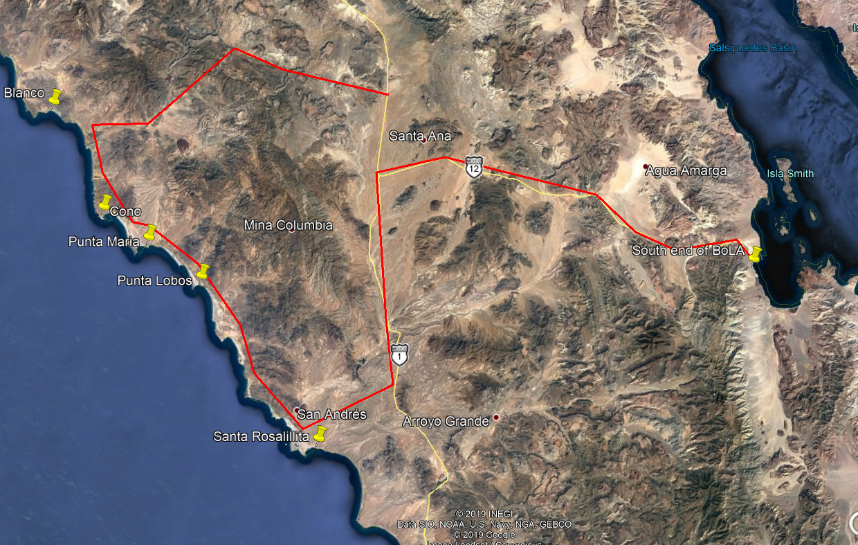
I can give you much more stuff to do. One of them being a 1.5 day exclusion to the Pacific coast to see the BEST beaches of the Seven Sisters (Punta Lobos, Punta Maria, Cono). Very epic and pretty easy.

Let me know and I'll drop you a round trip track for it.


[Edited on 1-21-2020 by JZ]

micah202 - 1-20-2020 at 07:49 PM


thanks man,, it's all good for now.

Google earth,,, it just gobbles too many gigs, for the power of my tech.
...if only there was a way to switch it to mapview,, but then I guess it would be google maps.
Is there a way to view your attachments on Google maps,, if there is, I'm not finding that either.


JZ - 1-20-2020 at 07:55 PM

You can also load them on Gaia or Back Country Navigator on your phone.

GE doesn't take much space though. You can run it on almost any PC that has a halfway decent internet connection. Doesn't take much space at all. So, something else must be amiss.

Here is a 1.5 day exclusion (1 day if you get up early), that I would highly recommend from BoLA. A world class adventure. About 65 miles in the dirt. 30 of it is very easy. 35 of it is medium. Only a couple miles might require 4x4.


[Edited on 1-21-2020 by JZ]

David K - 1-20-2020 at 09:52 PM

Micah, threads on Nomad often continue on with side bar topics. If the original question got answered, then these side bars keep the whole thread active. Be happy make more friends, etc. Need maps? Print some out... It's the old fashion way to navigate!

micah202 - 1-20-2020 at 09:59 PM

Yah, sure Dave.

Like the 'hotspring thread' and it's obvious searchable title. that's been building up useful information for years., much help from you,,, I was hoping the same for this one,, collect useful information in one place.

A number of sidebar topics can dilute the intent.
ah, well,, far be it for me to be a thread police. ;D

[Edited on 1-21-2020 by micah202]

JZ - 1-20-2020 at 10:19 PM

Good thread op. Hope we helped you a little.


micah202 - 1-20-2020 at 10:24 PM

Quote: Originally posted by JZ  
Good thread op. Hope we helped you a little.


...Definitely! All questions answered, and more!

I'm looking forward to my visit,, nevermore will I pass BOLA without at least a night or two stop over :spingrin:

David K - 1-21-2020 at 09:00 AM

Everything seems to work out in Baja California and on Baja Nomad!Travel safe!
:light:

micah202 - 1-21-2020 at 11:57 AM

Quote: Originally posted by David K  
Everything seems to work out in Baja California and on Baja Nomad!Travel safe!
:light:


So true,, lots of adventures, but never a bad experience,,, except the time I parked my car overnight in Playa TJ.

...but that's another story, and I knew better. <;~[

[Edited on 1-21-2020 by micah202]