| Pages:
1
..
16
17
18
19
20
..
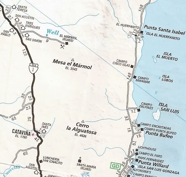
23 |
elbeau
Nomad

Posts: 256
Registered: 3-2-2011
Location: Austin, TX
Member Is Offline
|
|
| Quote: | Originally posted by David K
Could you put a pointer on, or circle over your 'arches'... on the Terraserver image (or all three)? |
The Terraserver image was taken in January, 2008 while the other three images were all taken around June, 2003 if I remember right (I'll verify if I
get some time tonight). The Bing vs Google images are both taken from a relatively similar angle, but the Terraserver image was taken from a
direction significantly westward of the other two images. The Terraserver image also appears (based on other nearby features not visible in my post
last night) to have been taken in the early morning hours based on the deep shadows being cast from the SouthEast (again, not in my arch photo because
the arch hillside is mostly facing the sun in the photo...the shadows can be seen vividly at the "mission site" which I will post tonight or whenever
I get a chance).
So...What this means is that the Terraserver image was taken five years after the other images, it has completely different shadows, it was taken
during January when everything was brown, and it was taken from a VERY different angle. That all sounds bad, but it's only bad for comparing images.
It's VERY GOOD for offering up new information. In the case of my "arches", the new information it offers up is that they don't look much like arches
all the time...bummer...but it doesn't rule them out either as I'll try to show when I get some more time.
| Quote: | | The El Tule in the book is very likely not the same place. It is grouped with other mine regions most are south of La Paz. There is no historic 'Santa
Cruz' (as a neighbor) near El Volcan. |
I can't find any information on 'Santa Cruz' near the site either and I fear you could be right about it being a reference to another place, but it
would be nice to try to pin it down. The article calls it the "Real de Santa Cruz" (road to Santa Cruz?), so it's possible that it's not referencing
a town near San Antonio, just a road...but I'm speculating...I really don't know. What is apparent is that the author names many places all over Baja
during those paragraphs including La Paz, the Colorado River, San Antonio, some islands, and many more places. In other words, his subject matter
seems macroscopic in nature...he's describing generalities about Baja for the most part. If I'm correct about that context, then describing the
"mining districts" could reasonably include the El Volcan (then called the El Tule) arroyo. Again, I'm just speculating, the author isn't specific.
If someone knows about a "Real de Santa Cruz" near another "San Antonio" site, please let us know.
| Quote: | | If there was running water in El Volcan, I would bring my gold pan! There is just south at Cataviña and Santa Maria (very limited) and north in Arroyo
Grande and Arroyo Matomi. |
Well, we know there's water year-round at El Volcan just a few miles from the sites, and Tom and Bill reported water standing with vegetation growing
around it in the arroyo at various locations as you hike toward the "arch" and "mission" sites. You mentioned a Jesuit reference to "Agua de Santa
Isabel" if I remember right. Then there's Agua Dulce to the SouthWest which is prominently mentioned and well-known. It is nearer to the site than
Santa Maria. Then there's the well-known spring 12 miles from the site towards the Sea of Cortez that is the known starting point for a mission story
you posted (your photos of this spring are found at various parts of this thread). The enormous El Marmol onyx deposits show that water has been
consistently near the site, even in the ancient past, and that onyx is still being formed at El Volcan.
Now, I'm not trying to say that El Volcan is some kind of WaterWorld...only that there are a significant number of descriptions of water in and around
the arroyo. I think that the reason that the water is not better described in the literature is because of the high mineral content and very bad
taste of it. Travelers sound like they tended to use the water near Santa Maria, Agua Dulce, and San Pablo on their way up the peninsula...which
seems to make sense. The El Volcan arroyo is kind of out-of-the-way when it comes to the travel routes I've been reading about. It just isn't a
compelling place to go for most people, but not necessarily because of a lack of water I think. ...so, you might just want to bring that gold pan you
mentioned  you might not find Jesuit treasure, but you don't need to leave
empty-handed either. you might not find Jesuit treasure, but you don't need to leave
empty-handed either. 
|
|
|
David K
Honored Nomad
Posts: 64545
Registered: 8-30-2002
Location: San Diego County
Member Is Offline
Mood: Have Baja Fever
|
|
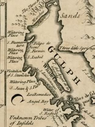
The Aguage de Santa Isabel is on the 1757 Jesuit map... An aguaje or aguage is a place where ships could find water... and naming that one Santa
Isabel (along with the low range of mountains in that area) is what sparked that area to be searched.
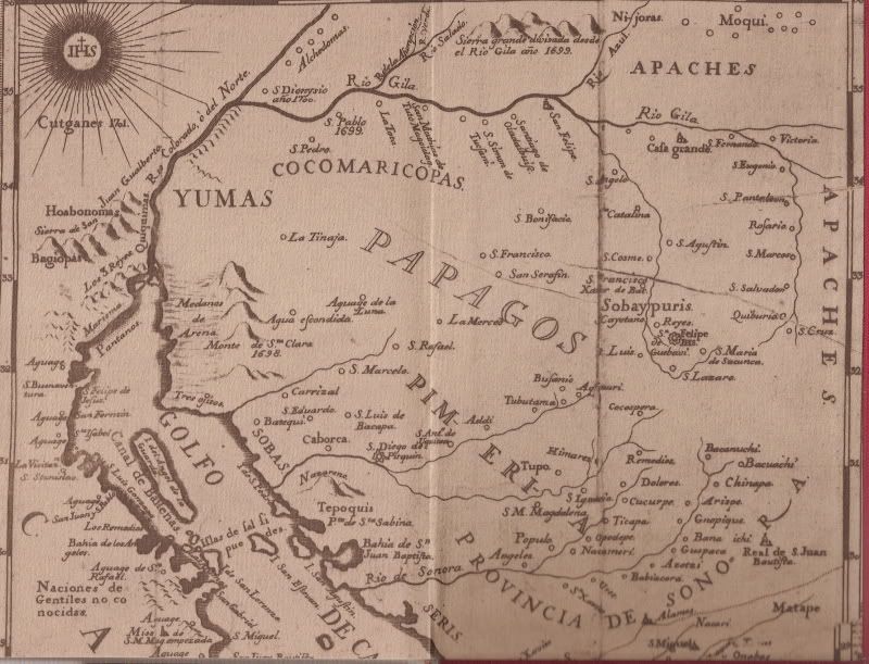
It is the third aguage down the coast of Baja from the Colorado delta:
1) 'Aguaje' at the bay named San Felipe de Jesus (San Felipe)
2) 'Aguage San Fermin' (Punta San Fermin is where Arroyo Matomi reaches the sea)
3) 'Aguge Santa Isabel' (note that lower case s is spelled with an f: Santa Ifabel)
Here is a clearer close up:
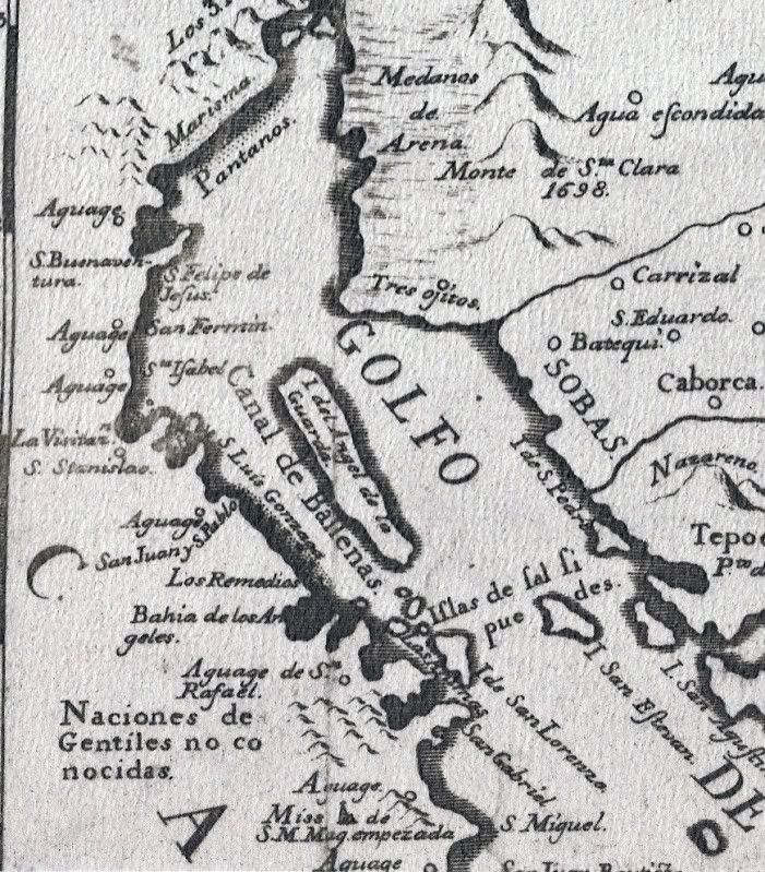
Here is a close up of the pirated (literally) English version:
|
|
|
David K
Honored Nomad
Posts: 64545
Registered: 8-30-2002
Location: San Diego County
Member Is Offline
Mood: Have Baja Fever
|
|
| Quote: | Originally posted by elbeau
The article calls it the "Real de Santa Cruz" (road to Santa Cruz?), so it's possible that it's not referencing a town near San Antonio, just a
road...but I'm speculating...I really don't know. |
Actually 'real' means royal (as in 'belonging to the king')... El Camino Real = The Royal Road or the King's Highway.
Ore mills were called 'reals' in the 1700's, as the ore belonged (in part) to the king... and if anyone stole from the king... off with his head!
Because of the mention of San Antonio, I am thinking the author is refering to the Real de Santa Ana (the silver processing center south of San
Antonio, south of La Paz). Perhaps there was a Santa Cruz 'real' for the local mines?
|
|
|
David K
Honored Nomad
Posts: 64545
Registered: 8-30-2002
Location: San Diego County
Member Is Offline
Mood: Have Baja Fever
|
|
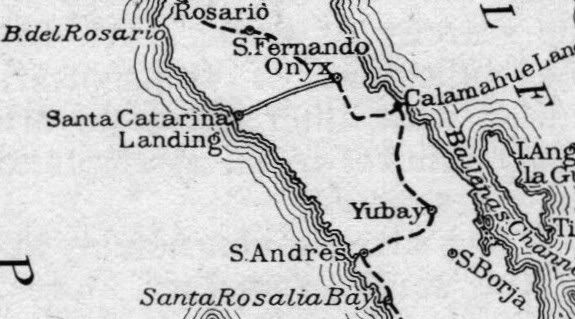
AGUA DULCE 29º52.97', 114º49.38' (NAD27)
Here is Agua Dulce... on the Camino Real between Santa Maria and San Fernando:

Elizabeth at Agua Dulce... Turn north from Hwy. 1 between
Km. 160-161 (29º51.56', 114º50.35'). Go 1.4 mi. to old Baja main road, turn left for 0.3 mi. then right 0.3 more. Hike into gully.
Above the gully... only a palm shows the spring:


Here is a photo from Neal Johns showing Agua Dulce's water and palm:

[Edited on 4-21-2011 by David K]
|
|
|
elbeau
Nomad
Posts: 256
Registered: 3-2-2011
Location: Austin, TX
Member Is Offline
|
|
| Quote: | Originally posted by David KOre mills were called 'reals' in the 1700's, as the ore belonged (in part) to the king... and if anyone stole
from the king... off with his head!
Because of the mention of San Antonio, I am thinking the author is referring to the Real de Santa Ana (the silver processing center south of San
Antonio, south of La Paz). Perhaps there was a Santa Cruz 'real' for the local mines? |
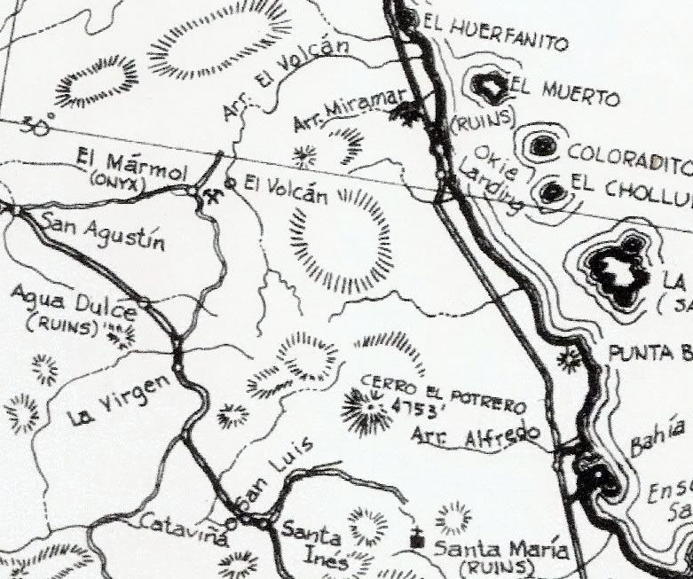
Actually, I think I might have pinned this one down. This is a modern map, but look at how well it fits the text's description of "Real de Santa Cruz
immediately South of San Antonio". Now, that doesn't mean that "El Tule" in his text is El Volcan, it could still be different, but the proximity of
El Volcan to "the neighbors of Santa Cruz" is intriguing. The author mentions Santa Cruz mines then says the "rivulet of El Tule" exposed the
placers, then says "the neighbors of Santa Cruz" took advantage of the opportunity "in this locality"...which really could be interpreted as meaning
that the rivulet of El Tule was in the Santa Cruz locality, or that the neighbors went to the locality of El Tule...it's still a little
ambiguous...but maybe worthy of you bringing your gold pan 
The El Volcan area is the greenish area in the bottom-right corner of the Google Earth overlay image.


And here's what I think is the modern "Rancho Santa Cruz" close up:

|
|
|
David K
Honored Nomad
Posts: 64545
Registered: 8-30-2002
Location: San Diego County
Member Is Offline
Mood: Have Baja Fever
|
|
Those are newer cattle/ farm ranches... quite a great distance from El Marmol. Valladares was a gold producing area about 100 years ago... next door
to today's Rancho Santa Cruz (near Meling's Ranch).
|
|
|
elbeau
Nomad
Posts: 256
Registered: 3-2-2011
Location: Austin, TX
Member Is Offline
|
|
| Quote: | Originally posted by David K
Those are newer cattle/ farm ranches... quite a great distance from El Marmol. Valladares was a gold producing area about 100 years ago... next door
to today's Rancho Santa Cruz (near Meling's Ranch). |
I'm sure the ranches are modern, I wasn't suggesting otherwise. Like I said, it's a modern map. You certainly know the history of the area better
than me, do you know if these were settled areas back then?
Also, is the Santa Cruz you mentioned in the cape region oriented directly south of San Antonio? I'll try to look it up myself tonight, but maybe you
know off the top of your head.
Yes, El Volcan is farther away from the map's Santa Cruz than I would have hoped, but it is true that the author is really jumping all over the
peninsula while he describes things on that page. It's does seem out of context though. How many places do we know of named El Tule back then? It's
a common-enough name that when googling it I run into other Spanish settlements in other places, including one near the cape. Does the southern El
Tule area fit the description of the sediment and placers that the author describes?
Like I said, I'll try to look these questions up myself. I'm not asking you to take time out of your schedule, but perhaps you know the answers to
some of these.
|
|
|
bajalou
Ultra Nomad
Posts: 4459
Registered: 3-11-2004
Location: South of the broder
Member Is Offline
|
|
From the book "Lower California and It's Natural Resources" by E. W Nelson, 1905-1906.
P.79 - Drainages of the Sierra Juarez --
Palm Spring, Tako, Guadalupe, Polomar, Agua Caliente, Tule & Aroryo Grande
P. 92 opposite - Plate 24, #1 El Tule Arroyo, a clear stream in Canyon at junction of Sierra el los Tinajuas and Sierra Juarex.
P.25 "Onyx mine near the upper end of El Tule Arroyo". -- well at San Augistin 50 ft deep.
P.81-82 "Dry channels to the coast south of San Pedro Matir Mountains." - A few of these have a little water in the upper parts of their channels.
Among these may be mentioned the following arroyos - Matomi, Santa Maria, San Fransquito, Calamahue, Santa Agueda. (San Agueda provides water to
Santa Rosalia)
May be other "El Tule" washes on the peninsula that aren't mentioned, but he does mention the one near the onyx mine but no mention of water.
No Bad Days
\"Never argue with an idiot. People watching may not be able to tell the difference\"
\"The trouble with doing nothing is - how do I know when I\'m done?\"
Nomad Baja Interactive map
And in the San Felipe area - check out Valle Chico area |
|
|
David K
Honored Nomad
Posts: 64545
Registered: 8-30-2002
Location: San Diego County
Member Is Offline
Mood: Have Baja Fever
|
|
| Quote: | Originally posted by bajalou
From the book "Lower California and It's Natural Resources" by E. W Nelson, 1905-1906.
P.79 - Drainages of the Sierra Juarez --
Palm Spring, Tako, Guadalupe, Polomar, Agua Caliente, Tule & Aroryo Grande
P. 92 opposite - Plate 24, #1 El Tule Arroyo, a clear stream in Canyon at junction of Sierra el los Tinajuas and Sierra Juarex.
P.25 "Onyx mine near the upper end of El Tule Arroyo". -- well at San Augistin 50 ft deep.
P.81-82 "Dry channels to the coast south of San Pedro Matir Mountains." - A few of these have a little water in the upper parts of their channels.
Among these may be mentioned the following arroyos - Matomi, Santa Maria, San Fransquito, Calamahue, Santa Agueda. (San Agueda provides water to
Santa Rosalia)
May be other "El Tule" washes on the peninsula that aren't mentioned, but he does mention the one near the onyx mine but no mention of water.
|
Good job Lou!
|
|
|
David K
Honored Nomad
Posts: 64545
Registered: 8-30-2002
Location: San Diego County
Member Is Offline
Mood: Have Baja Fever
|
|
| Quote: | Originally posted by elbeau
| Quote: | Originally posted by David K
Those are newer cattle/ farm ranches... quite a great distance from El Marmol. Valladares was a gold producing area about 100 years ago... next door
to today's Rancho Santa Cruz (near Meling's Ranch). |
I'm sure the ranches are modern, I wasn't suggesting otherwise. Like I said, it's a modern map. You certainly know the history of the area better
than me, do you know if these were settled areas back then?
Also, is the Santa Cruz you mentioned in the cape region oriented directly south of San Antonio? I'll try to look it up myself tonight, but maybe you
know off the top of your head.
Yes, El Volcan is farther away from the map's Santa Cruz than I would have hoped, but it is true that the author is really jumping all over the
peninsula while he describes things on that page. It's does seem out of context though. How many places do we know of named El Tule back then? It's
a common-enough name that when googling it I run into other Spanish settlements in other places, including one near the cape. Does the southern El
Tule area fit the description of the sediment and placers that the author describes?
Like I said, I'll try to look these questions up myself. I'm not asking you to take time out of your schedule, but perhaps you know the answers to
some of these. |
I mentioned that your Real de Santa Cruz sounds like the Real de Santa Ana... which is south of San Antonio... just south of Hwy. 1. I don't know a
Real de Santa Cruz in Baja Sur.
|
|
|
BAJACAT
Ultra Nomad
Posts: 2902
Registered: 11-21-2005
Location: NATIONAL CITY, CA
Member Is Offline
|
|
Come on guys, are you guys crazy, How can you plan a trip bye just beliving what a unknown person said's.You guys should know better... than just go
by a story and then to jump into your truck and go...what is the world coming too...
I GUESS IM KRAZY TWO, BECAUSE IM GOING WITH YOU GUYS,THIS IS WHAT EXPLORING BAJA IS ALL ABOUT. a story tell over the camp fire , about a old mine or
ancient rocks paintings kind off like whats to make go and find it. Thats how I came to explore Palomar canyon, just by reading a story in a piece of
paper.
So what time are we leaving, can I caravan with DK what time are you living SD on Friday...
So thanks Elbeau, for getting us infected with the exploration virus, is not like we are already infected by the BAJA virus.....so see ya in BAJA..
BAJA IS WHAT YOU WANTED TO BE, FUN,DANGEROUS,INCREDIBLE, REMOTE, EXOTIC..JUST GO AND HAVE FUN.....
|
|
|
David K
Honored Nomad
Posts: 64545
Registered: 8-30-2002
Location: San Diego County
Member Is Offline
Mood: Have Baja Fever
|
|
It's cool Jose... see you a week from Friday!
|
|
|
TMW
Select Nomad
Posts: 10659
Registered: 9-1-2003
Location: Bakersfield, CA
Member Is Offline
|
|
Jose that is great. I plan on leaving Hemit on Thursday from my brothers place and get down there early cause I want to check out the road to the La
Olividada mine and maybe take pictures of the cross area Elbeau has marked. Several of Ken's group can't make it and I've emailed him to see if they (
I think there are 3 Jeeps now) want to join us even if it's just to do the mine road run and look at the geyser.
|
|
|
bajalou
Ultra Nomad
Posts: 4459
Registered: 3-11-2004
Location: South of the broder
Member Is Offline
|
|
Great José
Tom, I'm heading around that way on Thursday also so I'll probably catch up somewhere in the afternoon.
No Bad Days
\"Never argue with an idiot. People watching may not be able to tell the difference\"
\"The trouble with doing nothing is - how do I know when I\'m done?\"
Nomad Baja Interactive map
And in the San Felipe area - check out Valle Chico area |
|
|
David K
Honored Nomad
Posts: 64545
Registered: 8-30-2002
Location: San Diego County
Member Is Offline
Mood: Have Baja Fever
|
|
EL MARMOL ON MAPS 1905 +
Originally called 'Onyx' and 'El Tule'...
1905
1911 (1905 expedition)
1919 (1905 expedition)

1919
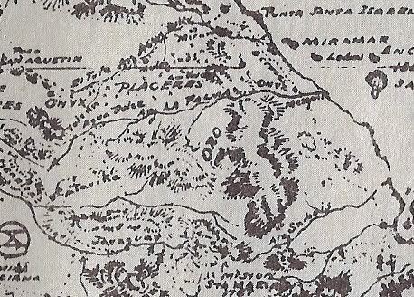
1930
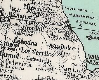
1941
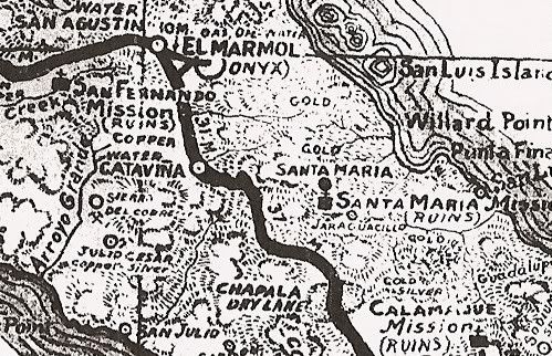
1962
1974
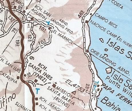
1975
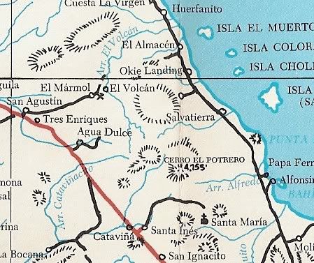
2003
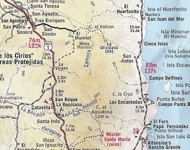
Two errors on the Almanac/ Mexican topo maps: Arroyo el Volcan mis named Zamora and La Olvidada mis spelled with an extra i (Olividada).
2007
[Edited on 4-21-2011 by David K]
|
|
|
BajaBlanca
Select Nomad
Posts: 13166
Registered: 10-28-2008
Location: La Bocana, BCS
Member Is Offline
|
|
is this el marmol where the onyx school is located ????
|
|
|
bajalou
Ultra Nomad
Posts: 4459
Registered: 3-11-2004
Location: South of the broder
Member Is Offline
|
|
| Quote: | Originally posted by BajaBlanca
is this el marmol where the onyx school is located ???? |
Yes
No Bad Days
\"Never argue with an idiot. People watching may not be able to tell the difference\"
\"The trouble with doing nothing is - how do I know when I\'m done?\"
Nomad Baja Interactive map
And in the San Felipe area - check out Valle Chico area |
|
|
BAJACAT
Ultra Nomad
Posts: 2902
Registered: 11-21-2005
Location: NATIONAL CITY, CA
Member Is Offline
|
|
| Quote: | Originally posted by TW
Jose that is great. I plan on leaving Hemit on Thursday from my brothers place and get down there early cause I want to check out the road to the La
Olividada mine and maybe take pictures of the cross area Elbeau has marked. Several of Ken's group can't make it and I've emailed him to see if they (
I think there are 3 Jeeps now) want to join us even if it's just to do the mine road run and look at the geyser. |
Tom so by Friday you will be at the arroyo...
BAJA IS WHAT YOU WANTED TO BE, FUN,DANGEROUS,INCREDIBLE, REMOTE, EXOTIC..JUST GO AND HAVE FUN.....
|
|
|
elbeau
Nomad
Posts: 256
Registered: 3-2-2011
Location: Austin, TX
Member Is Offline
|
|
Perhaps I'm spending too much time on the water argument, but I keep bumping into more little tidbits:
First, early on in this thread it was mentioned that other nomads had tried to take MC's through the arroyo from both directions. What I find
particularly interesting about Corky's trip up the arroyo is how he describes the arroyo as:
| Quote: | | a very pretty area. Quite a bit of water and green stuff. |
TW describes the trip down the arroyo as:
| Quote: | | El Volcan would not cooperate. We hit a rock pile right off but not too bad, then after 100 yards of sand more rocks. It seemed the farther we went
the bigger the rocks. After about 2.5 miles we start walking to scout the wash. Another mile or so and the wash narrows to about 50 feet with large
smooth black rock. The elevation drop appeared very noticable. We could probably have taken the bikes down but getting back up would be another story.
|
Here's the link of Corky's and TW's MC/walking trip down the arroyo several years ago (note from earlier posts in this thread that even though they
walked past the "mission site", they say they did not leave the arroyo and venture up the hillsides:

Here's my best guess at the smooth black rocks they describe:

Here's the link to Corky's and Bill's trip up the arroyo from the gulf side:

...and from farther out:

In addition, I found a picture I love of someone drinking directly from the El Volcan geyser (no word on how he felt afterward):

And I found the following quote in the April 1958 issue of Desert Magazine regarding water availability at the El Marmol mines:

Does anybody know if El Marmol has a source of water?...or is this mineralized water they talk about probably actually coming from El Volcan?
Next, please take a look at this GE image. It's a VERY large feature...look at the measurements and at the level of detail of the surrounding
terrain. Before you say that this is just a shadow effect, take a look at the drainage patterns of the two inlets and one outlet and look for the
shadows of the surrounding terrain. This is not a shadow. This is a large, clearly-visible body of standing water up the hillside from an arroyo
North of the El Volcan arroyo. I don't know if it's a permanent body of water:

...and a closeup:

Here's the
KML file for the water
and the KML file for the trips up and down the arroyo
|
|
|
David K
Honored Nomad
Posts: 64545
Registered: 8-30-2002
Location: San Diego County
Member Is Offline
Mood: Have Baja Fever
|
|
Good mornig Beau,
You have done great with your research!
BillB has a Rokon 2WD motor bike.. it can almost climb up a wall... He had that when he and Corky1 (and Max) explored Arroyo el Volcan (Zamora) up
from the gulf coast side. BillB thought about pulling the Rokon up the (dry) waterfall with a rope so he could continue to ride up the wash and see if
he could get to the El Marmol road. I met BillB when he flew out from Texas to attend my Viva Baja #4 party... His goal then was to retrace Erle
Stanley Gardner's expedition into Sal Si Puedes Canyon, north of L.A. Bay ('Hovering Over Baja')... Then it was to find shortcut across Baja (Hwy. 1
to the gulf).
That dark area you found north of Arroyo el Volcan is indeed a pool of water... I have seen it also on GE. See a similar 'tinaja' at Yubay... no
spring, but a place where flash flood or rain water keeps for long periods of time... Tinajas were important sources of water to the Indians and other
early Baja travelers.
The photo from the Baja Adventure Book of Victor Cook drinking water looks to be below or at the base of the geyser... since it looks flat.
Here is Elizabeth at the geyser vent on top of the onyx dome/ El Volcan:
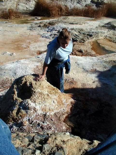
There is no drinkable water at El Marmol... it was trucked in 10 miles from San Agustin. There was no road to El Volcan from El Marmol when the town
was active, just a mule trail... so don't think they got water from there. Perhaps there was a well of water used for cleaning/ bathing purposes (as
mentioned). In fact, near the airport for El Marmol there is/ was a windmill... so that may have been the town well mentioned (about 1-2 miles away)?
Again, great work and research!!!
[Edited on 4-22-2011 by David K]
|
|
|
| Pages:
1
..
16
17
18
19
20
..
23 |
|


