| Pages:
1
..
9
10
11
12
13 |
David K
Honored Nomad

Posts: 64533
Registered: 8-30-2002
Location: San Diego County
Member Is Offline
Mood: Have Baja Fever
|
|
San Pedrito in Senterfitt's Books
1967
1969
1982 Note the villa in the background.
1987
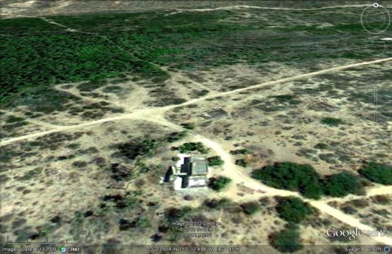
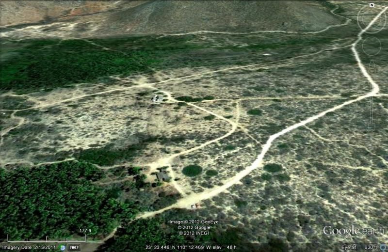
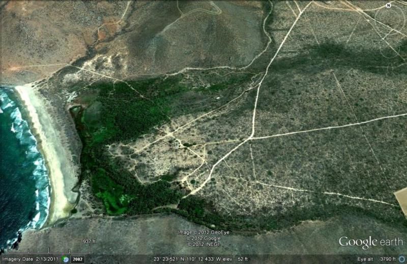
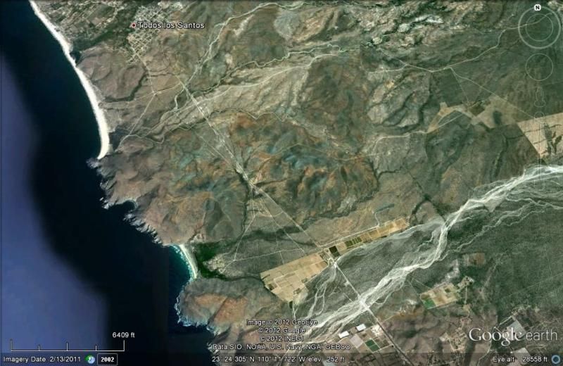
Now, here are Google Earth Satellite views of San Pedrito from close to high up, taken in 2009... starting at the general's villa:
[Edited on 11-13-2015 by David K]
|
|
|
AmoPescar
Senior Nomad
Posts: 835
Registered: 7-15-2006
Location: North San Diego County
Member Is Offline
Mood: Need a Fish Taco and a Pacifico!
|
|
EXCELLENT JOB DAVID...
Really wonderful reports and pictures. As usual...great details, maps, descriptions and commentary!!
Thanks for taking the time to do the reports and for sharing your trip with us!!
Happy that you and Elizabeth had such a fun trip!
Miguelamo  YES YES YES YES
Nomad Amigos...Here\'s hoping you all have safe Baja travels, amazing sunrises, sunny days, comforting breezes, beautiful sunsets, tasty tacos,
cold cervezas and frosty margaritas!!
|
|
|
David K
Honored Nomad
Posts: 64533
Registered: 8-30-2002
Location: San Diego County
Member Is Offline
Mood: Have Baja Fever
|
|
Thank you Michael! I really wish to see you back south with your big happy face on!
San Gregorio Trail, April, 2001
[Edited on 8-17-2012 by David K]
|
|
|
capt. mike
Elite Nomad
Posts: 8085
Registered: 11-26-2002
Location: Bat Cave
Member Is Offline
Mood: Sling time!
|
|
great history on san pedrito. i don't think it is in existance now? the todos santos airport now is not that close to the water. it is now being
developed by the owner of another baja info site who is working with DGAC in mex city and the ejido.
formerly Ordained in Rev. Ewing\'s Church by Mail - busted on tax fraud.......
Now joined L. Ron Hoover\'s church of Appliantology
\"Remember there is a big difference between kneeling down and bending over....\"
www.facebook.com/michael.l.goering |
|
|
Jack Swords
Super Nomad
Posts: 1094
Registered: 8-30-2002
Location: Nipomo, CA/La Paz, BCS
Member Is Offline
|
|
Just north of San Pedrito is a little bay called Puerto Algodones, visible in your photos before the big beach off Todos Santos. When we lived in
Todos Santos I rode my Honda 90 trail motorcycle up over the hill down to the remains of the pier for diving. The pier was for offloading sugar cane
(I know, algodones = cotton, Mexico!). The casa at San Pedrito was vacant in the '80s and we camped there many times. We were told that passion
fruit was raised to the east (there are concrete waterways). The freshwater lagoon behind the beach was increasing in size killing the palms. We
netted some fish from this lagoon could not identify them...strange ones. There was a fresh water spring on the southside of the beach near the rock
ruins with "agua" written on the cliff face. Now, I heard, parking is risky due to breakins. Swimming from the panga haulout on Todos Santos' beach
(Punta Lobos) around to San Pedrito is full of life (lobos) and in season you can hear the whales singing underwater. Nice blowhole there too.
Thanks David for the great trip photos. You outdid yourself! You should write a book...
|
|
|
David K
Honored Nomad
Posts: 64533
Registered: 8-30-2002
Location: San Diego County
Member Is Offline
Mood: Have Baja Fever
|
|
Thanks Jack!
[Edited on 8-18-2012 by David K]
|
|
|
David K
Honored Nomad
Posts: 64533
Registered: 8-30-2002
Location: San Diego County
Member Is Offline
Mood: Have Baja Fever
|
|
It has been a real pleasure bringing this trip report to you... Being there is better, so go!!! If you can't, then I hope you get your fix here, on
Baja Nomad...
If there are any details I left out or unanswered questions, just ask!
Here or u2u or email to: info*AT*vivabaja.com (make sure Baja is in the subject line).
|
|
|
David K
Honored Nomad
Posts: 64533
Registered: 8-30-2002
Location: San Diego County
Member Is Offline
Mood: Have Baja Fever
|
|
Got an email from Barry, and I believe he did finally see the photos. They are hosted on Photobucket, not Nomad... in order to post more than one at a
time. If anyone cannot view the photos, please let me know!
|
|
|
Marc
Ultra Nomad
Posts: 2756
Registered: 5-15-2010
Location: San Francisco & Palm Springs
Member Is Offline
Mood: Waiting
|
|
Thanks again DK.
|
|
|
David K
Honored Nomad
Posts: 64533
Registered: 8-30-2002
Location: San Diego County
Member Is Offline
Mood: Have Baja Fever
|
|
My pleasure Marc...
I welcome any questions on the sites, the trip, the truck, whatever!
|
|
|
koolaukid
Newbie
Posts: 22
Registered: 12-1-2011
Member Is Offline
|
|
THAT was a killer trip report.
Spent the last couple of days digesting the report, trying to follow your narrative on a map and looking into some of the interesting "extras" that
were also mentioned like the Rancho Naranja between Todos Santos and San Jose Del Cabo. As a pilot, thought it interesting and quirky (and
fascinating) to have included the airport plates, a lot like the modern ones. Loved your photos and the dialog really took us along for the ride.
Learned a lot about Baja from your report.
You may recognize my username, my daughter and I drove the length of Baja (our first visit) last Christmas and I posted a trip report to this forum.
Well to make a long story short I loved it so much a buddy and I are going to ship our bikes from Hawaii and ride dual sport motorcycles down Baja
this February. So I'd like to ask a few questions.
What kind of printed map do you carry?
What maps are best for the GPS? I have a Garmin.
How can I find the route of the old main road prior to MX-1? And finally,
Do you have GPS tracks for this trip? I hope you don't mind my asking these questions but just following your trip report with the anecdotal mentions
of local history, animals and sites to visit was educational.
Anyway great report, I probably spent more time reading it and researching things you mentioned than it took you to write the thing, lol.
Scott
|
|
|
David K
Honored Nomad
Posts: 64533
Registered: 8-30-2002
Location: San Diego County
Member Is Offline
Mood: Have Baja Fever
|
|
Aloha Scott and Mahalo for you nice words!
It was a great trip indeed... and not only did the Nomads get a break from me posting here for two weeks, but I got to give them this big report! 
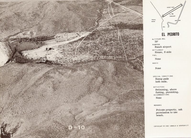
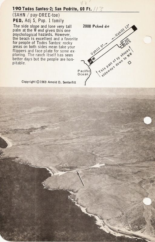
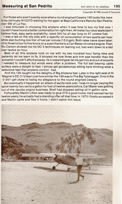
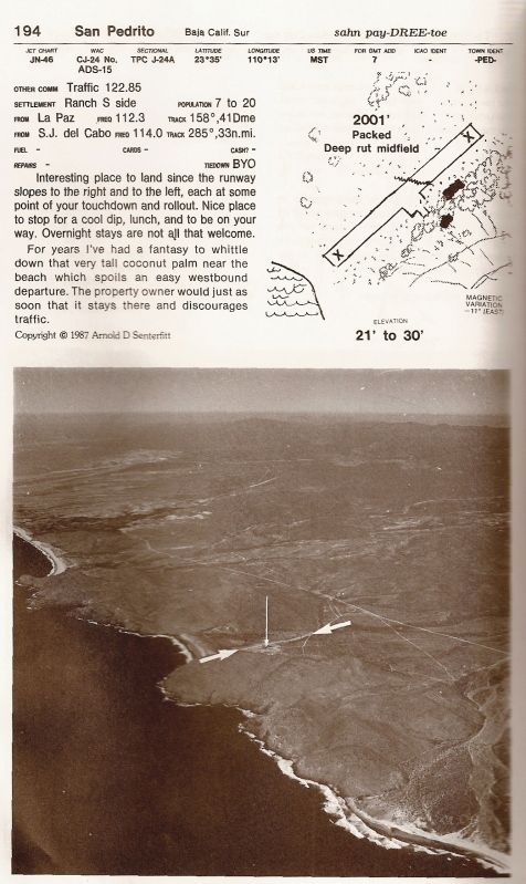
The runway photos are from Arnold Senterfitt's Airports of Baja California (several editions) and San Pedrito seems to have been a special place for
Arnold to stop and measure the runway! I have flown over some of Baja once in a single engine (Alfonsina's to Calexico), but never got my license... I
enjoy the aerial photos for a 'bird's eye view' of Baja! Sadly, most of the great runways that Arnold had in his books have been ditched by the
military to reduce drug pick up points.
I don't really use a map much on the road, as I already am very familiar with much of the peninsula, however, for reference or discovery, I use the
Baja California Almanac (topo map book) available from http://DiscoverBaja.com or http://BajaBooksAndMaps.com or even http://BajaAlmanac.com plus I have the handy folding road map from the Auto Club (available maybe from the first two sources I gave or the AAA
office to members).
I don't have a GPS track, but I did proved a few maps where I thought the details were needed. ... Once you get a map, take out a highlighter and
follow us:
Crossed south at Tecate, used the toll road (2-D) all the way to Hwy. 5, then south to Coco's Corner (with an overnight at Shell Island, Km. 26 south
of San Felipe... that is 3 miles south of Laguna Percebu on the map).
At Coco's, we turned EAST on the Baja 1000 course then south to Calamajue Canyon to Hwy. 1 at El Crucero. Hwy. 1 all the way to La Paz (with a few
nights at Bahia Concepcion along the way).
We did a day trip to Los Barriles after stops at El Triunfo, San Antonio, the Real de Santa Ana. Back to La Paz via Punta Pescadero.
We did a day trip Todos Santos, San Pedrito, Cabo, Santiago, Bat Cave at Las Cuevitas, and back to La Paz. This was using Hwy. 19 and Hwy. 1.
Coming north, we used Hwy. 1 and stayed a night at Bahia Concepcion, then on north past Santa Rosalia and just west of San Ignacio taking the paved
road to Punta Abreojos then the salt flat to La Bocana then the dirt to Bahia Asuncion for a couple nights at Juan y Shari's Bed & Breakfast (the
best!). Went fossil hunting one day... found some sharks teeth from prehistoric times... many miles from today's ocean shore.
From Asuncion we took the paved road to Vizcaino at Hwy. 1, then a few miles north we turned on the dirt road signed for Guillermo Prieto (now a ghost
town), then north from there, across the state border and visit to Mission Santa Gertrudis (1752). Then we went back west towards El Arco and up to
Pozo Aleman ghost town, then went east with a side trip to see the huge cave art site... then on east to Punta San Francisquito Resort (too windy and
run down looking), so north to Bahia San Rafael for the night, camping on the beach.
The next day we continued north to Bahia de los Angeles to have lunch with Nomads Mary Ann, Paulina and Dern, then on out to Hwy. 1 and north to
Laguna Chapala, then onto the dirt for Coco's Corner, Gonzaga, pavement just a few miles north and to Shell Island for the last night.
The way home was Hwy. 5 to the toll road to Tecate and cross into the US at Tecate. EASY!
|
|
|
David K
Honored Nomad
Posts: 64533
Registered: 8-30-2002
Location: San Diego County
Member Is Offline
Mood: Have Baja Fever
|
|
Here is a great question, I didn't cover above:
| Quote: | Originally posted by koolaukid
How can I find the route of the old main road prior to MX-1?
Scott |
I have posted an entire series on finding the old main Baja road from El Rosario to San Ignacio... PART 1 is HERE: http://forums.bajanomad.com/viewthread.php?tid=48770
The old main road, just beyond Bahia Concepcion, also went south via San Jose Comondu or La Purisima and NOT through Loreto... Although one could
drive up to San Javier from Loreto and out to Santo Domingo to meet the road from Comondu.
|
|
|
koolaukid
Newbie
Posts: 22
Registered: 12-1-2011
Member Is Offline
|
|
Wow David really appreciate the time and effort you made to post such a complete reply. The old road is interesting and I'll try to follow it on a
map, I hope for this to provide some alternative routing and exploring when we go.
Another questions, how does the old road relate to the original El Camino Real that linked the missions?
|
|
|
David K
Honored Nomad
Posts: 64533
Registered: 8-30-2002
Location: San Diego County
Member Is Offline
Mood: Have Baja Fever
|
|
Now you really know how to keep me on a computer, don't you!
Basically, from Tijuana to El Rosario, Hwy. 1 is very close to the Camino Real.
From El Rosario to San Fernando, it is south of Hwy. 1/ and the old road.
From San Fernando to Agua Dulce it is on or just south of the old road & Hwy. 1.
Then it goes north of Hwy. 1 and out to Santa Maria then down towards Gonzaga where Hwy. 5 is on or near the Camino Real to near Coco's Corner. South
of Coco's it goes to Calamajue through a mountain canyon and south in Calamajue Canyon then out and along the foot of the Sierra La Asamblea to
Yubay... along the L.A. Bay road route (but north of it) until it crosses it as it heads south to San Borja.
From San Borja it goes south, in the mountains to come out near Rancho La Union, crosses the El Aco/ San Francisquito road to get to Santa Gertrudis,
then back in the mountains agian to San Ignacio. There are actual multiple Camino Reals that were used depending on the time of year and visitas that
were needing services, along the way.
Look at the links, and for the most part there is no connection between the Camino Real and the old road or Hwy. 1 south of San Agustin/Agua Dulce.
The Camino Real was for foot or mule traffic, and autos needed easier routes.
I have posted the El Camino Real maps and satellite images as well...
I linked them all on my Baja Missions pages at VivaBaja.com to make finding them on Nomad easy at the end of Part 3, Visitas:
http://vivabaja.com/missions2/page13.html
There you will see the following, but hotlinked:
EL CAMINO REAL (satellite images and maps)
ECR-1 Santa Maria to San Borja
ECR-2a San Borja to Santa Gertrudis (Sierra route)
ECR-2b San Borja to Santa Gertrudis (Golfo route)
ECR-3a Santa Gertrudis to San Ignacio (Pacifico route)
ECR-3b Santa Gertrudis to San Ignacio (Sierra route)
ECR-4 San Ignacio to Guadalupe
ECR-5 Guadalupe to Comondu
ECR-6 Comondu to Loreto
HARRY CROSBY's 1977 ECR Notes and Maps
HOWARD GULICK's 1954 ECR Maps
|
|
|
koolaukid
Newbie
Posts: 22
Registered: 12-1-2011
Member Is Offline
|
|
David,
On our earlier trip with my daughter you had recommended visiting Bahia de los Angeles. When we got there it was a cold, windblown day, there was no
one around the the place looked deserted. We had lunch and blew out of town but I always felt bad because you provided so much help for our first
trip.
This new information you've provided will keep me busy for a couple of days, you've been a great source of info and write a helluva trip report.
Thanks again.
|
|
|
David K
Honored Nomad
Posts: 64533
Registered: 8-30-2002
Location: San Diego County
Member Is Offline
Mood: Have Baja Fever
|
|
Cold, windblown? Sounds like winter! When did you go?
I have many many side-trips based out of Bahia de los Angeles just for such times... as it is very hot in the summer and fall, for many. Driving in an
AC car makes summer visits tolerable, but when it is cold or windy is an ideal time to see the many sites that are not involved with being on the
beach or on the bay. When you can't go fishing... go exploring! SEE http://vivabaja.com/tours to design a self guided tour to the many many points of interest centered at various Baja destinations.
Hope you go in a warmer time or just get lucky and miss any wind or rain.
We were at Bahia de los Angeles on New Years when it rained one day... it was beautiful the next, so be patient and remember you are in Mexico and THE
word is mañana which does not mean 'tomorrow', but instead means 'not today'!
|
|
|
preston
Nomad
Posts: 159
Registered: 2-3-2005
Member Is Offline
|
|
SF through BOLA or Los Arcos
David:
Another epic series of posts and full of useful information. When you are ready to publish your book, let me know.
Quick question: I'm planning a trip to San Francisquito in early October and was wondering about the best approach (BOLA or Los Arcos). I have a 2WD
Tacoma with the stock wheels. Distance through BOLA would be less ... but is it more risky given my vehicle?
An opinion would be appreciated.
Thanks
|
|
|
David K
Honored Nomad
Posts: 64533
Registered: 8-30-2002
Location: San Diego County
Member Is Offline
Mood: Have Baja Fever
|
|
| Quote: | Originally posted by preston
David:
Another epic series of posts and full of useful information. When you are ready to publish your book, let me know.
Quick question: I'm planning a trip to San Francisquito in early October and was wondering about the best approach (BOLA or Los Arcos). I have a 2WD
Tacoma with the stock wheels. Distance through BOLA would be less ... but is it more risky given my vehicle?
An opinion would be appreciated.
Thanks |
Book is being published in mass, next week: http://oldmissions.com
If you mean a book about my Baja trips and explorations... well, maybe someday, after this mission book pays for itself!
Just about 2 months ago we went to San Francisquito and used both roads (most of)... The drive in from the south via Mission Santa Gertrudis was fine,
and easy 2WD driving. We didn't go through El Arco, but instead through Guillermo Prieto from Hwy. 1 just a few miles north of Vizcaino.
The road to Bahia de los Angeles from San Francisquito is a bit rougher, less used... but, as you say, shorter from the U.S. and you can stop at
Pancho's Bahia San Rafael. 2WD as well, but there is the one big grade along the way.
Lot's of photos in my July trip report (link below)!
San Francisquito was real windy and not very attractive, sadly. We camped at San Rafael beach instead... a couple miles north of Pancho's.
|
|
|
preston
Nomad
Posts: 159
Registered: 2-3-2005
Member Is Offline
|
|
Thanks for the information on the 2 options to SF. I think we will do the same as you, but in reverse.
Just purchased your book .... hope to get it before I leave on my trip on October 4th!
|
|
|
| Pages:
1
..
9
10
11
12
13 |