BajaNomad

HURACÁN LORENA… Hurricane season got spicy!

mtgoat666 - 8-30-2025 at 06:10 PM

500 PM PDT Sat Aug 30 2025

2. South of Southern Mexico:
A tropical wave is producing a large area of disorganized showers and thunderstorms south of southern Mexico. An area of low pressure is expected to form from this system early next week, and it is likely to become a tropical depression by the middle of next week while moving west-northwestward or northwestward at 10 to 15 mph just offshore of the southwestern coast of Mexico.
* Formation chance through 48 hours...medium...40 percent.
* Formation chance through 7 days...high...80 percent.


[Edited on 9-3-2025 by mtgoat666]

JZ - 8-30-2025 at 07:08 PM

Goat roots for people to suffer.


Suffer?

AKgringo - 8-30-2025 at 07:47 PM

From what I have seen so far this season, the entire peninsula has been way too dry. I am rooting for something to come along and drop some rain.

The forecast models on Windy show the storm centers probably will stay offshore while at least Baja Sur will catch some much needed showers.

[Edited on 8-31-2025 by AKgringo]

mtgoat666 - 8-30-2025 at 07:59 PM

Quote: Originally posted by JZ  
Goat roots for people to suffer.


You are sad little troll. Grow up, pee wee.

Tacayo - 8-31-2025 at 08:28 AM

I stay in touch with Mx friends in BCS who pray every day for rain. If it comes in the form of a hurricane they'll gladly accept. It beats seeing all of their livestock starve to death. It's been a rough couple of years. Some folks whose families have been ranchers for generations tell me that they can't hang on much longer, so I say bring on the rain in whatever form it comes in.

surabi - 8-31-2025 at 09:53 AM

Quote: Originally posted by JZ  
Goat roots for people to suffer.


What a stupid comment. I guess you also think that meteorologists that report an imminent hurricane or tornado or flood are "rooting for people to suffer".

[Edited on 8-31-2025 by surabi]

ligui - 8-31-2025 at 03:20 PM

Hi everyone ! I'm in ligui right now and wanted to say we got a nice rain two days ago for about 2 hours .

Boy everyone was suffering !!!!

Man JZ you are something else

Thanks goat for bringing up the weather. :thumbup:

Heading up the Baja on Tuesday. Came down last week and it was sad it see how dry it was.

It's been four years since we have had any real amount of rain.

So JZ just so you know everyone here is hoping to Suffer.

Bring it on !!!! Viva Baja !!!!

AKgringo - 9-1-2025 at 08:49 AM

Using the Windy rain and thunder model, this is what the forecast for Thursday looks like; https://www.windy.com/-Rain-thunder-rain?rain,2025-09-04-21,...

mtgoat666 - 9-1-2025 at 09:18 AM

Quote: Originally posted by AKgringo  
Using the Windy rain and thunder model, this is what the forecast for Thursday looks like; https://www.windy.com/-Rain-thunder-rain?rain,2025-09-04-21,...


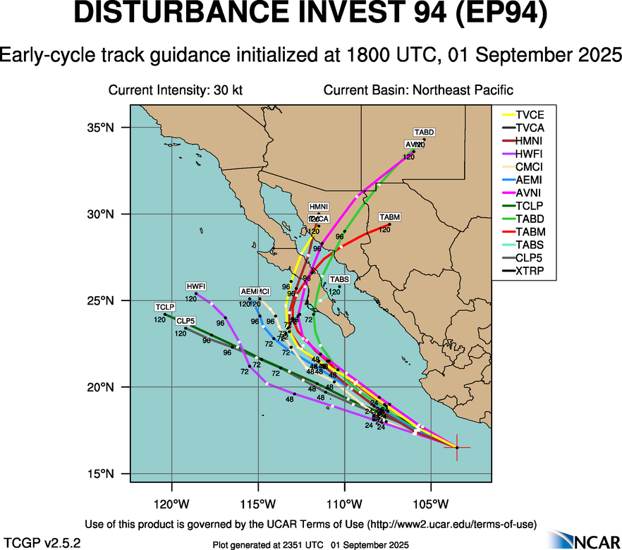
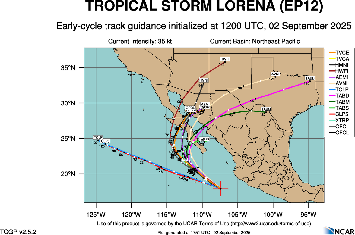
If it grows, will be named TS Lorena. Right now forecasts show two possibilities, it continues west over pacific, or curves east and comes ashore somewhere in mid-bcs…


AKgringo - 9-1-2025 at 09:37 AM

I have tentative plans for an October trip down the peninsula. I love it when the desert blooms!

A perfect backroad for me is one that I barely make it through without getting stuck. I try to avoid "off-road" to give nature a better chance of thriving.

surabi - 9-1-2025 at 11:20 AM

Quote: Originally posted by AKgringo  
I try to avoid "off-road" to give nature a better chance of thriving.


Good for you. Too bad there are those who seem to think it's perfectly okay to regard sensitive ecosystems as their personal playground, without a thought about what they are running over (just because it's too small for you to see doesn't mean it's not there or unimportant), what their gas fumes and oil leaks are doing to the environment, or how the noise of their motorized vehicles affects the wildlife.

mtgoat666 - 9-1-2025 at 11:45 AM

As of 11:00 AM PDT Mon Sep 1 2025...
South of Southwestern Mexico (EP94):
Showers and thunderstorms associated with a tropical wave located
less than 150 miles off the coast of southwestern Mexico are
starting to become better organized, and recent satellite-derived
wind data indicate that winds to 35 mph are present in the
disturbance close to the coast of Mexico. This system is expected
to become a tropical depression by the middle of the week. This
system is expected to move west-northwestward to northwestward at
10 to 15 mph off the coast of southwestern Mexico during the next
couple of days, then could turn northward and approach the Baja
California peninsula later this week. Interests in the Baja
California peninsula should monitor the progress of the
disturbance, as watches or warnings could be required for portions
of this area on Tuesday. Regardless of development, heavy rainfall
is possible across coastal portions of southwestern and
west-central Mexico today through mid-week. Heavy rainfall is also
expected across Baja California Sur and northwestern Mexico Tuesday
night through late this week. This heavy rainfall could lead to
flash flooding, especially in mountainous areas.
* Formation chance through 48 hours...high...80 percent.
* Formation chance through 7 days...high...90 percent.

pauldavidmena - 9-1-2025 at 01:40 PM

Weathernerds TC Guidance shows a pretty good opportunity for at least rain when Loretta approaches BCS.

surfhat - 9-1-2025 at 02:10 PM

The ad that showed up in JZ's contribution was perfect.

I know the ads change by the minute, but this ad showed a man sleeping on his side with drool pooling and coming out of his mouth for sleep apnea.

For once an ad and a post had perfect timing sharing the same space. I couldn't help but imagine that was JZ.

All in fun all.

AKgringo - 9-1-2025 at 02:29 PM

In that same space, the ad that pops up for me is one for off-road tires! That must be an omen!

mtgoat666 - 9-1-2025 at 03:11 PM


[Edited on 9-2-2025 by BajaNomad]

mtgoat666 - 9-1-2025 at 09:06 PM


020242_5day_cone_no_line_and_wind.png - 180kB

[Edited on 9-2-2025 by BajaNomad]

latitude32 - 9-1-2025 at 09:43 PM

time to hit your favorite south facing beach! hard charging midgets like Weasel will find solid overhead, everyone else chest to head high. trifecta conditions, go get em :D

BajaNomad - 9-2-2025 at 10:30 AM

If you want to follow this more closely, these are perhaps two of the best resources online to do so:

https://www.nhc.noaa.gov/?epac

https://www.wunderground.com/hurricane?index_region=ep

BajaNomad - 9-2-2025 at 10:50 AM


[Edited on 9-2-2025 by BajaNomad]

bajatrailrider - 9-2-2025 at 07:14 PM

Quote: Originally posted by surabi  
Quote: Originally posted by AKgringo  
I try to avoid "off-road" to give nature a better chance of thriving.


Good for you. Too bad there are those who seem to think it's perfectly okay to regard sensitive ecosystems as their personal playground, without a thought about what they are running over (just because it's too small for you to see doesn't mean it's not there or unimportant), what their gas fumes and oil leaks are doing to the environment, or how the noise of their motorized vehicles affects the wildlife.
Talk about Stupid comments Surabi your number one . We ride our dirt bikes no leaking oil no more noise then a car . The tires we use you cant tell we where there the next day . We ride and enjoy too bad for Baja Blow hard;)

surabi - 9-2-2025 at 09:24 PM

No more noise than a car, neither of which should be driving through unpopulated natural areas. And whether or not your tire tracks can be seen has nothing to do with the creatures you disturb and run over that are too small to see, their nesting grounds, etc.
But those are obviously not things you care about as long as you "ride and enjoy".

pauldavidmena - 9-3-2025 at 04:34 AM

Meanwhile, the National Hurricane Center public advisory from 2 AM has this to say about rainfall, certainly the most closely watched component of this storm:

RAINFALL: Bands of heavy rainfall will continue to impact Baja
California Sur and move into southeastern Baja California and
southwestern Sonora by Thursday, with this rainfall potentially
persisting through Friday. Rainfall totals of 5 to 10 inches, with
maximum amounts of 15 inches, are possible across portions of Baja
California Sur and far southeast Baja California through Friday.
This will bring the risk of life-threatening flash floods and
mudslides, especially in areas of higher terrain.

David K - 9-3-2025 at 07:42 AM

Quote: Originally posted by surabi  
No more noise than a car, neither of which should be driving through unpopulated natural areas. And whether or not your tire tracks can be seen has nothing to do with the creatures you disturb and run over that are too small to see, their nesting grounds, etc.
But those are obviously not things you care about as long as you "ride and enjoy".


It's our planet, too!
Humans are not an alien species to this planet (at least not for the past 20,000 years).

I apologize for even mentioning off-road!

AKgringo - 9-3-2025 at 08:42 AM

Now can we please stay on topic about the storm systems affecting Baja?

(or start a new thread?)

[Edited on 9-3-2025 by AKgringo]

lencho - 9-3-2025 at 10:45 AM

Quote: Originally posted by AKgringo  
Now can we please stay on topic about the storm systems affecting Baja?

(or start a new thread?)

Thank you!

I just heard from a friend: "Acá en Los Cabos, ¡mucha agua!":biggrin:

[Edited on 9-3-2025 by lencho]

mtgoat666 - 9-3-2025 at 02:08 PM

Hurricane Lorena Discussion Number 8
NWS National Hurricane Center Miami FL EP122025
200 PM MST Wed Sep 03 2025

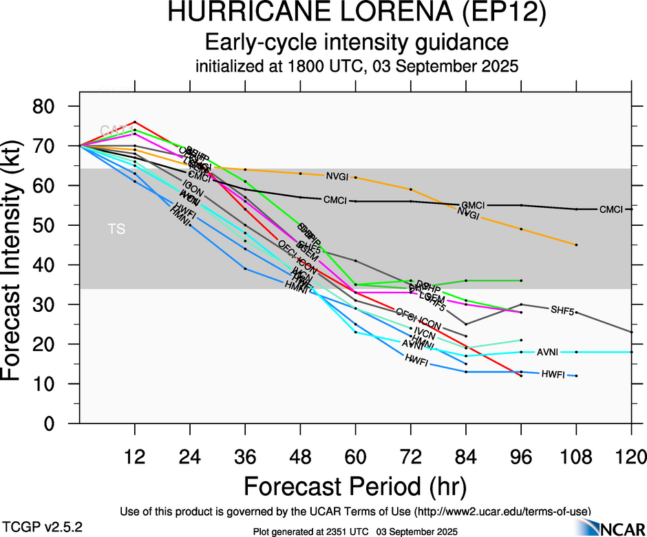
Lorena could still intensify for another 6-12 hours while it remains
over warm water and in low wind shear conditions. By 18 hours, the
hurricane is expected to cross the 26C sea-surface temperature
isotherm while southwesterly wind shear also begins to significantly
increase. These conditions are expected to lead to rapid weakening
beginning by Thursday afternoon. Only minor adjustments were made
to the official intensity forecast. The official forecast is at the
high end of the intensity guidance through 24 hours, and then lies
closer to the middle of the guidance envelope thereafter.

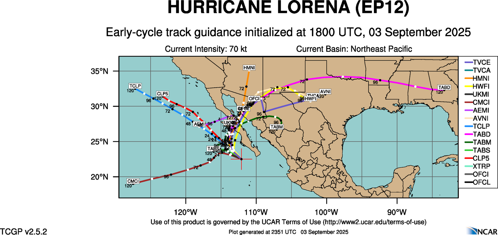
The track guidance hasn't changed too much, but the TVCE, GFEX, and
other consensus models are a bit faster with the northeastward
motion beyond 36 h, and the NHC track was sped up a bit after that
time. Otherwise, only minor changes were made to the NHC track
forecast. It should be noted that several models indicate a farther
left track, with dissipation over water without making landfall.
This scenario is possible if the hurricane rapidly weakens by
Thursday night and starts to decouple due to the aforementioned
increasing southwesterly shear. Regardless of which track scenario
pans out, there is very high confidence that heavy rainfall amounts
leading to significant flooding will occur in Baja California Sur,
especially since the southwesterly upper-level winds favor deep
convection to the right side of Lorena.


[Edited on 9-3-2025 by mtgoat666]

BajaNomad - 9-3-2025 at 02:17 PM

RAINFALL: Bands of heavy rainfall will continue to impact Baja California Sur and move into southwestern Sonora by Thursday, with this rainfall potentially persisting through Friday. Rainfall totals of 5 to 10 inches, with maximum amounts of 15 inches, are possible across portions of Baja California Sur and southwestern Sonora through Friday. This will bring the risk of life-threatening flash floods and mudslides, especially in areas of higher terrain. Farther northeast, 1 to 3 inches of rain, with localized totals up to 5 inches, are expected from portions of the Mexico states of Sinaloa north and northeast into portions of Arizona and southern New Mexico through Saturday afternoon, bringing the potential for isolated to scattered flash flooding.

https://www.nhc.noaa.gov/refresh/graphics_ep2+shtml/032042.s...


032042_INTQPF_edit.png - 191kB

BajaNomad - 9-3-2025 at 02:19 PM


Windy vs the other models

AKgringo - 9-3-2025 at 06:53 PM

Even now (Wed evening) Windy is showing the storm center staying west of Baja, then slowly falling apart. Presumably, prevailing wind shear will then carry copious quantities of rain northeastward all the way to the mainland.

I hope that their model is correct...rain with less wind would be great.

I'm looking forward to some reports from anyone that is down there right now, particularly about potential flood damage.

mtgoat666 - 9-3-2025 at 07:10 PM

Quote: Originally posted by AKgringo  
Even now (Wed evening) Windy is showing the storm center staying west of Baja, then slowly falling apart. Presumably, prevailing wind shear will then carry copious quantities of rain northeastward all the way to the mainland.

I hope that their model is correct...rain with less wind would be great.

I'm looking forward to some reports from anyone that is down there right now, particularly about potential flood damage.


Windy spits out model runs without human interpretation. You can select which model is shown. Windy is ok for predicting next 24 hours, but is unreliable for forecasting a few days out…

NHC narrative explains that the western/offshore dissipation of the hurricane is likely only if the storm rapidly weakens after it enters cooler water and shear tomorrow…

lencho - 9-3-2025 at 07:17 PM

Quote: Originally posted by AKgringo  
I'm looking forward to some reports from anyone that is down there right now, particularly about potential flood damage.

Just Zoomed with a friend in SJD who said they'd gotten lots of rain all night, typical local flooding with not much wind damage.

Plus, a bunch of minor earth tremors! She said the epicenter was fairly local, around Querencia. :wow:

BornFisher - 9-3-2025 at 07:23 PM

So it`s Windy vs NHC!! Stay tuned! Let`s hope a good portion of southern and central Baja gets needed hydration without the floods. Many years ago, I had a conversation with a guy who had a place south of San Felipe. He rode out a hurricane there. He said it was terrifying. He had an empty Home Depot bucket in his yard that overflowed! Probably about 20 years ago.

Rain/wind reports in BCS

geraldalexander7 - 9-3-2025 at 08:11 PM

Can anyone in Baja Sur report on what they are observing?

mtgoat666 - 9-4-2025 at 06:39 AM

Thursday AM, and storm is slowing down, decreasing in strength. Good news is the TS winds not expected at landfall. Still going to rain cats and dogs through the weekend…

https://www.nhc.noaa.gov/graphics_ep2.shtml?start#contents

BoenBaja - 9-4-2025 at 07:19 AM

Quote: Originally posted by geraldalexander7  
Can anyone in Baja Sur report on what they are observing?


Some rain in Bahía Asunción, no wind as of yet.

jedge42 - 9-4-2025 at 07:30 AM

Quote: Originally posted by geraldalexander7  
Can anyone in Baja Sur report on what they are observing?


75.5mm rain yesterday here in Buenavista, just drizzle since midnight, clearing up nicely now ... no wind, some lightning and thunder, but nothing too crazy ...

jake

SFandH - 9-4-2025 at 07:36 AM

Photo from Facebook of Cabo Street


Cabo street flood.jpg - 43kB

SFandH - 9-4-2025 at 07:38 AM


Cabo flood.jpg - 130kB

SFandH - 9-4-2025 at 07:41 AM


Cabo flood 2.jpg - 133kB

AKgringo - 9-4-2025 at 10:00 AM

Quote: Originally posted by mtgoat666  


Windy spits out model runs without human interpretation. You can select which model is shown.


I forgot that I could change models on Windy, but seems to being doing ok on autopilot for this storm.

Just think how much more screen time I would have had over the last week if I had been changing forecast models!

SFandH - 9-4-2025 at 10:07 AM

I use windy.com, and its default model (ECMWF) was correct in predicting the storm would stay in the Pacific. The other models predicted it crossing the peninsula.

EngineerMike - 9-4-2025 at 10:21 AM

Latest NOAA track shows Lorena taking a 60° left turn, BIG change in direction, indicates eye crossing the Horn of Baja just west of Guerrero Negro. Hopeful sigh of relief for Sta.Rosalia-Mulegé.

Photos of Cabo look like a genuine mess to clean up

mtgoat666 - 9-4-2025 at 11:25 AM

Looks like the storm will be slow moving and linger through saturday… gonna be a muddy mess…


[Edited on 9-4-2025 by mtgoat666]

SFandH - 9-5-2025 at 02:43 AM

Timely BCS weather information with photos, videos, and reader comments.

https://www.facebook.com/ClimaSudcaliforniano

Many parts of BCS are getting soaked.


[Edited on 9-5-2025 by SFandH]