At Mile 2.0 (from the schoolhouse) is this major fork (see photo here)... GPS is NAD27: N29 59.49', W114 47.53', elev. 2,200'
Turn RIGHT for El Volcan... log to El Volcan continues below...
This fork from space: Fork right to El Volcan, 2.0 mi.
------------------------------------------------------------------------------------------------
Later this day, on our way out... I took the left branch to see where it went!!! I had followed it on the Google satellite images to where it went
beyond the high resolution into a blur!
Some of us Nomads are seeking a route to the gulf shore... could this be the one??? Set to Mile 0.0 if you go left:
Going left, on this mystery road... you pass two tracks that lead to the right to some digs in the canyon... continue ahead.
Come to a fork at Mile 2.7, but that rejoins up ahead...
Mile 2.9, fork: To the right ends in 0.7 mi. after passing a left fork at mi. 0.5. (needs to be checked)... Going on left fork:
Mile 3.3, fork, we go right (NE) and follow it for 2.7 more miles to where it ends... a little past a clearing that may have been the start of a
airstrip!? The left fork at Mile 3.3 still needs exploring...
[Edited on 12-19-2006 by David K]David K - 1-23-2006 at 11:42 PM
This is the area north/left of the Mile 2.0 fork from El Marmol...
The GPS at the northernmost point I drove is N30 03.52', W114 48.20'
[Edited on 1-24-2006 by David K]
On to El Volcan!
David K - 1-23-2006 at 11:46 PM
Soon after taking the right fork at Mile 2.0, one begins a long down grade to Arroyo el Volcan (mislabled as Arroyo Zamora in the Baja Almanac/
Mexican topos). I suggest only 4WD or VW buggies beyond Mile 2.0... for the climb back up.David K - 1-23-2006 at 11:47 PM
We stop for some photos with the elephant trees...David K - 1-23-2006 at 11:52 PM
Arroyo el Volcan is reached at Mile 4.0 (N29 59.84', W114 46.13', elev.1,840')... the onyx dome/ cold water geyser and pools are up the arroyo (to the
right)... You can drive about 0.2 mi. in the sand arroyo, then hike the second 0.2 mi. to 'El Volcan'.
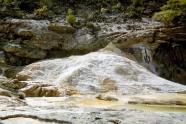
We first went across the creek and over a low rise to the white mineral spring hillside on the La Olividada road...
This white slope is at mile 4.3 from El Marmol...
[Edited on 1-24-2006 by David K]David K - 1-23-2006 at 11:55 PM
Some of the mineral springs on the white hillside...
(I came here in 1974 and again with Lorenzo de Baja in 2000, thinking this was El Volcan! Thanks to Jack Swords, when I cam a third time in 2003, I
hiked up the arroyo to the true El Volcan!)
N29 59.86', W114 45.88', elev. 1,895'
David K - 1-23-2006 at 11:58 PM
My truck at the bottom of the white hillside to show how close you can drive to this site...
We then went the 0.3 mile back to Arroyo el Volcan and turned up the wash... other's car tracks were there.
Some tracks also went down the arroyo... where Corky on a motorcycle reported boulders soon blocked the way to the gulf coast...
[Edited on 1-26-2006 by David K]David K - 1-23-2006 at 11:59 PM
Big cliffs along the arroyo's east side contain caves...
[Edited on 1-24-2006 by David K]David K - 1-24-2006 at 12:00 AM
This is where we parked the Toyota and began the short hike to El Volcan... This is looking south, up stream towards El Volcan...David K - 1-24-2006 at 12:01 AM
Some mineral pools along the arroyo...David K - 1-24-2006 at 12:02 AM
An arm's length photo of Elizabeth and I... note truck to show distance of hike...
[Edited on 1-25-2006 by David K]David K - 1-24-2006 at 12:04 AM
Baja Angel finds the sun deck, next to the 'bottomless' pool!David K - 1-24-2006 at 12:06 AM
I spot some stalactites in the making... and climb up a cliff to get a close up photo...David K - 1-24-2006 at 12:07 AM
We see the onyx dome of El Volcan...
N29 59.55', W114 46.22', elev. 1,885'
David K - 1-24-2006 at 12:10 AM
The dome is a geyser growing on the right/ west bank of the arroyo. It erupts once a month for several minutes spewing water and gas some 60 feet into
the air (reportedly)... What fortune to get a photo of this!!! Anyone???
This photo was taken in April 2003 for comparison.
[Edited on 1-24-2006 by David K]David K - 1-24-2006 at 12:11 AM
Here I am at the top...David K - 1-24-2006 at 12:12 AM
[Edited on 1-26-2006 by David K]David K - 1-24-2006 at 12:14 AM
The bubbling soda spring (cold), at the top... I wish I had recording of the deep sound!David K - 1-24-2006 at 12:15 AM
Here's Baja Angel at the top of El Volcan (The Volcano)... Baja's cold water geyser!David K - 1-24-2006 at 12:17 AM
Looking down arroyo el Volcan from the onyx dome... my truck can be seen as a silver dot... to show it isn't a very long hike...
[Edited on 1-25-2006 by David K]David K - 1-24-2006 at 12:21 AM
Walking back to my truck, we follow the base of each side of the arroyo looking for Indian petroglyphs... Can you see little Baja Angel at the base of
that cliff? We didn't find any. There have been some cave ins and land slides... that may have covered any up?
In Part 3, I have photos of the El Marmol cemetery... I will also add GPS waypoints to the other driving details...
[Edited on 1-25-2006 by David K]Mexray - 1-24-2006 at 12:30 AM
...as always, David. You guys are having way to much fun on those road trips! That one of you near the Elephant tree appears to really be 'Drew
Carey' in shades...if you look close!
Fun stuff, keep em' coming!David K - 1-24-2006 at 12:46 AM
Baja is a land of adventure! Every dirt road goes somewhere interesting and beautiful... How can anyone not have a great time???
Send me a photo of Drew Carey that has you thinking that... my diet has started, by the way!TMW - 1-24-2006 at 11:09 AM
Great report DK.
David, sorry, I didn't mean to imply...
Mexray - 1-24-2006 at 01:16 PM
...well, you know - I only thought your 'face' looked like Drew Carey, not necessarily your body...
I'm trying to get back on the old 'diet' routine, also!David K - 1-24-2006 at 01:22 PM
Quote:
Originally posted by Mexray
...well, you know - I only thought your 'face' looked like Drew Carey, not necessarily your body...
I'm trying to get back on the old 'diet' routine, also!
Hey, I know I am overweight! With so much GREAT food in Baja and me going several times a month to Tijuana and beyond, it is impossible to not look
'happy' (well fed)!!
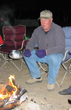
Here is a photo of Mexray at the Nuevo Mazatlan campfire working on his 'Jiffy Pop' diet!!!
David K - 1-25-2006 at 01:00 AM
Some GPS has been added... more to come... wanted to get the final (#3) part done... and it is now...
Look for better area map to replace the one I added tonight to Part 1, and a revised El Rosario town map...
Good night friends!TMW - 1-25-2006 at 07:31 PM
David did you know there is another small onyx dig further up the arroyo around the bend. The road coming in crosses the wash and there is a road to
the right that goes out to it.
second onyx pool
John M - 1-25-2006 at 08:37 PM
TW - I did a google earth check and see what may be the road end you wrote about. If you can get onto google earth and locate the end of the "road to
the right", would it be the apparent end at 29 59 28.57N & 114 46 14.48W ?
John M.David K - 1-25-2006 at 10:19 PM
Guys... Yes! When Lorenzo and I went and camped by the white slope in 2000... I walked that miners road up on the east side of Volcan arroyo... and
saw the digs and a big pool at the bottom of the cliff around the bend.
I was so close to seeing the onyx dome... but didn't know to look for it in the arroyo!
In my links to Baja Places from Space, I have a close up of El Volcan... and of course you can pan out from there to follow the road, see the white
slope, etc... Give me a minute and I will post the link here: El Volcan Onyx Dome
[Edited on 1-27-2006 by David K]David K - 1-26-2006 at 08:55 PM
Here is a closer in image of that map... Everyone should have the Baja Almanac (even with the mistakes: Arroyo Zamora is actually Arroyo el Volcan,
Mexico Hwy. #1 is south of the old road, which is shown as paved Mex. 1 between Sonora and Catavi?a)... http://www.baja-almanac.com
I added the location (per my GPS) of the mystery road that forks left, 2.0 miles from El Marmol... Also note the GPS location of point 'A' which is
the dry waterfall wall the stopped Corky, BillB, and mcgyver from going any further up Arroyo el Volcan.