BajaNomad
Not logged in [Login - Register]

Go To Bottom
Printable Version  
 Pages:  1  
Author: Subject: El Marmol, El Volcan 1-21-06 (Part 2)
David K
Honored Nomad
*********


Avatar


Posts: 64587
Registered: 8-30-2002
Location: San Diego County
Member Is Offline

Mood: Have Baja Fever

[*] posted on 1-23-2006 at 11:39 PM
El Marmol, El Volcan 1-21-06 (Part 2)


Continued from Part 1 at : http://forums.bajanomad.com/viewthread.php?tid=15255

At Mile 2.0 (from the schoolhouse) is this major fork (see photo here)... GPS is NAD27: N29 59.49', W114 47.53', elev. 2,200'

Turn RIGHT for El Volcan... log to El Volcan continues below...


This fork from space: Fork right to El Volcan, 2.0 mi.
------------------------------------------------------------------------------------------------
Later this day, on our way out... I took the left branch to see where it went!!! I had followed it on the Google satellite images to where it went beyond the high resolution into a blur!

Some of us Nomads are seeking a route to the gulf shore... could this be the one??? Set to Mile 0.0 if you go left:

Going left, on this mystery road... you pass two tracks that lead to the right to some digs in the canyon... continue ahead.

Come to a fork at Mile 2.7, but that rejoins up ahead...

Mile 2.9, fork: To the right ends in 0.7 mi. after passing a left fork at mi. 0.5. (needs to be checked)... Going on left fork:

Mile 3.3, fork, we go right (NE) and follow it for 2.7 more miles to where it ends... a little past a clearing that may have been the start of a airstrip!? The left fork at Mile 3.3 still needs exploring...

Airstrip from space


[Edited on 12-19-2006 by David K]


"So Much Baja, So Little Time..."

See the NEW www.VivaBaja.com for maps, travel articles, links, trip photos, and more!
Baja Missions and History On Facebook: https://www.facebook.com/groups/bajamissions/
Camping, off-roading, Viva Baja discussion: https://www.facebook.com/groups/vivabaja


View user's profile Visit user's homepage
David K
Honored Nomad
*********


Avatar


Posts: 64587
Registered: 8-30-2002
Location: San Diego County
Member Is Offline

Mood: Have Baja Fever

[*] posted on 1-23-2006 at 11:42 PM


This is the area north/left of the Mile 2.0 fork from El Marmol...

The GPS at the northernmost point I drove is N30 03.52', W114 48.20'

[Edited on 1-24-2006 by David K]


"So Much Baja, So Little Time..."

See the NEW www.VivaBaja.com for maps, travel articles, links, trip photos, and more!
Baja Missions and History On Facebook: https://www.facebook.com/groups/bajamissions/
Camping, off-roading, Viva Baja discussion: https://www.facebook.com/groups/vivabaja


View user's profile Visit user's homepage
David K
Honored Nomad
*********


Avatar


Posts: 64587
Registered: 8-30-2002
Location: San Diego County
Member Is Offline

Mood: Have Baja Fever

[*] posted on 1-23-2006 at 11:46 PM
On to El Volcan!


Soon after taking the right fork at Mile 2.0, one begins a long down grade to Arroyo el Volcan (mislabled as Arroyo Zamora in the Baja Almanac/ Mexican topos). I suggest only 4WD or VW buggies beyond Mile 2.0... for the climb back up.


"So Much Baja, So Little Time..."

See the NEW www.VivaBaja.com for maps, travel articles, links, trip photos, and more!
Baja Missions and History On Facebook: https://www.facebook.com/groups/bajamissions/
Camping, off-roading, Viva Baja discussion: https://www.facebook.com/groups/vivabaja


View user's profile Visit user's homepage
David K
Honored Nomad
*********


Avatar


Posts: 64587
Registered: 8-30-2002
Location: San Diego County
Member Is Offline

Mood: Have Baja Fever

[*] posted on 1-23-2006 at 11:47 PM


We stop for some photos with the elephant trees...


"So Much Baja, So Little Time..."

See the NEW www.VivaBaja.com for maps, travel articles, links, trip photos, and more!
Baja Missions and History On Facebook: https://www.facebook.com/groups/bajamissions/
Camping, off-roading, Viva Baja discussion: https://www.facebook.com/groups/vivabaja


View user's profile Visit user's homepage
David K
Honored Nomad
*********


Avatar


Posts: 64587
Registered: 8-30-2002
Location: San Diego County
Member Is Offline

Mood: Have Baja Fever

[*] posted on 1-23-2006 at 11:52 PM


Arroyo el Volcan is reached at Mile 4.0 (N29 59.84', W114 46.13', elev.1,840')... the onyx dome/ cold water geyser and pools are up the arroyo (to the right)... You can drive about 0.2 mi. in the sand arroyo, then hike the second 0.2 mi. to 'El Volcan'.

We first went across the creek and over a low rise to the white mineral spring hillside on the La Olividada road...
This white slope is at mile 4.3 from El Marmol...

[Edited on 1-24-2006 by David K]


"So Much Baja, So Little Time..."

See the NEW www.VivaBaja.com for maps, travel articles, links, trip photos, and more!
Baja Missions and History On Facebook: https://www.facebook.com/groups/bajamissions/
Camping, off-roading, Viva Baja discussion: https://www.facebook.com/groups/vivabaja


View user's profile Visit user's homepage
David K
Honored Nomad
*********


Avatar


Posts: 64587
Registered: 8-30-2002
Location: San Diego County
Member Is Offline

Mood: Have Baja Fever

[*] posted on 1-23-2006 at 11:55 PM


Some of the mineral springs on the white hillside...

(I came here in 1974 and again with Lorenzo de Baja in 2000, thinking this was El Volcan! Thanks to Jack Swords, when I cam a third time in 2003, I hiked up the arroyo to the true El Volcan!)


"So Much Baja, So Little Time..."

See the NEW www.VivaBaja.com for maps, travel articles, links, trip photos, and more!
Baja Missions and History On Facebook: https://www.facebook.com/groups/bajamissions/
Camping, off-roading, Viva Baja discussion: https://www.facebook.com/groups/vivabaja


View user's profile Visit user's homepage
David K
Honored Nomad
*********


Avatar


Posts: 64587
Registered: 8-30-2002
Location: San Diego County
Member Is Offline

Mood: Have Baja Fever

[*] posted on 1-23-2006 at 11:58 PM
N29 59.86', W114 45.88', elev. 1,895'


My truck at the bottom of the white hillside to show how close you can drive to this site...

We then went the 0.3 mile back to Arroyo el Volcan and turned up the wash... other's car tracks were there.

Some tracks also went down the arroyo... where Corky on a motorcycle reported boulders soon blocked the way to the gulf coast...

Here is the white slope from space: White Slope 1/4 mi. east of Arroyo el Volcan


[Edited on 1-26-2006 by David K]


"So Much Baja, So Little Time..."

See the NEW www.VivaBaja.com for maps, travel articles, links, trip photos, and more!
Baja Missions and History On Facebook: https://www.facebook.com/groups/bajamissions/
Camping, off-roading, Viva Baja discussion: https://www.facebook.com/groups/vivabaja


View user's profile Visit user's homepage
David K
Honored Nomad
*********


Avatar


Posts: 64587
Registered: 8-30-2002
Location: San Diego County
Member Is Offline

Mood: Have Baja Fever

[*] posted on 1-23-2006 at 11:59 PM


Big cliffs along the arroyo's east side contain caves...

[Edited on 1-24-2006 by David K]


"So Much Baja, So Little Time..."

See the NEW www.VivaBaja.com for maps, travel articles, links, trip photos, and more!
Baja Missions and History On Facebook: https://www.facebook.com/groups/bajamissions/
Camping, off-roading, Viva Baja discussion: https://www.facebook.com/groups/vivabaja


View user's profile Visit user's homepage
David K
Honored Nomad
*********


Avatar


Posts: 64587
Registered: 8-30-2002
Location: San Diego County
Member Is Offline

Mood: Have Baja Fever

[*] posted on 1-24-2006 at 12:00 AM


This is where we parked the Toyota and began the short hike to El Volcan... This is looking south, up stream towards El Volcan...


"So Much Baja, So Little Time..."

See the NEW www.VivaBaja.com for maps, travel articles, links, trip photos, and more!
Baja Missions and History On Facebook: https://www.facebook.com/groups/bajamissions/
Camping, off-roading, Viva Baja discussion: https://www.facebook.com/groups/vivabaja


View user's profile Visit user's homepage
David K
Honored Nomad
*********


Avatar


Posts: 64587
Registered: 8-30-2002
Location: San Diego County
Member Is Offline

Mood: Have Baja Fever

[*] posted on 1-24-2006 at 12:01 AM


Some mineral pools along the arroyo...


"So Much Baja, So Little Time..."

See the NEW www.VivaBaja.com for maps, travel articles, links, trip photos, and more!
Baja Missions and History On Facebook: https://www.facebook.com/groups/bajamissions/
Camping, off-roading, Viva Baja discussion: https://www.facebook.com/groups/vivabaja


View user's profile Visit user's homepage
David K
Honored Nomad
*********


Avatar


Posts: 64587
Registered: 8-30-2002
Location: San Diego County
Member Is Offline

Mood: Have Baja Fever

[*] posted on 1-24-2006 at 12:02 AM


An arm's length photo of Elizabeth and I... note truck to show distance of hike...


[Edited on 1-25-2006 by David K]


"So Much Baja, So Little Time..."

See the NEW www.VivaBaja.com for maps, travel articles, links, trip photos, and more!
Baja Missions and History On Facebook: https://www.facebook.com/groups/bajamissions/
Camping, off-roading, Viva Baja discussion: https://www.facebook.com/groups/vivabaja


View user's profile Visit user's homepage
David K
Honored Nomad
*********


Avatar


Posts: 64587
Registered: 8-30-2002
Location: San Diego County
Member Is Offline

Mood: Have Baja Fever

[*] posted on 1-24-2006 at 12:04 AM


Baja Angel finds the sun deck, next to the 'bottomless' pool!


"So Much Baja, So Little Time..."

See the NEW www.VivaBaja.com for maps, travel articles, links, trip photos, and more!
Baja Missions and History On Facebook: https://www.facebook.com/groups/bajamissions/
Camping, off-roading, Viva Baja discussion: https://www.facebook.com/groups/vivabaja


View user's profile Visit user's homepage
David K
Honored Nomad
*********


Avatar


Posts: 64587
Registered: 8-30-2002
Location: San Diego County
Member Is Offline

Mood: Have Baja Fever

[*] posted on 1-24-2006 at 12:06 AM


I spot some stalactites in the making... and climb up a cliff to get a close up photo...


"So Much Baja, So Little Time..."

See the NEW www.VivaBaja.com for maps, travel articles, links, trip photos, and more!
Baja Missions and History On Facebook: https://www.facebook.com/groups/bajamissions/
Camping, off-roading, Viva Baja discussion: https://www.facebook.com/groups/vivabaja


View user's profile Visit user's homepage
David K
Honored Nomad
*********


Avatar


Posts: 64587
Registered: 8-30-2002
Location: San Diego County
Member Is Offline

Mood: Have Baja Fever

[*] posted on 1-24-2006 at 12:07 AM


We see the onyx dome of El Volcan...


"So Much Baja, So Little Time..."

See the NEW www.VivaBaja.com for maps, travel articles, links, trip photos, and more!
Baja Missions and History On Facebook: https://www.facebook.com/groups/bajamissions/
Camping, off-roading, Viva Baja discussion: https://www.facebook.com/groups/vivabaja


View user's profile Visit user's homepage
David K
Honored Nomad
*********


Avatar


Posts: 64587
Registered: 8-30-2002
Location: San Diego County
Member Is Offline

Mood: Have Baja Fever

[*] posted on 1-24-2006 at 12:10 AM
N29 59.55', W114 46.22', elev. 1,885'


The dome is a geyser growing on the right/ west bank of the arroyo. It erupts once a month for several minutes spewing water and gas some 60 feet into the air (reportedly)... What fortune to get a photo of this!!! Anyone???


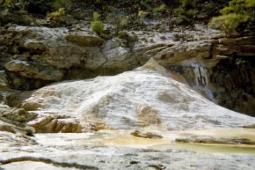
This photo was taken in April 2003 for comparison.


[Edited on 1-24-2006 by David K]


"So Much Baja, So Little Time..."

See the NEW www.VivaBaja.com for maps, travel articles, links, trip photos, and more!
Baja Missions and History On Facebook: https://www.facebook.com/groups/bajamissions/
Camping, off-roading, Viva Baja discussion: https://www.facebook.com/groups/vivabaja


View user's profile Visit user's homepage
David K
Honored Nomad
*********


Avatar


Posts: 64587
Registered: 8-30-2002
Location: San Diego County
Member Is Offline

Mood: Have Baja Fever

[*] posted on 1-24-2006 at 12:11 AM


Here I am at the top...


"So Much Baja, So Little Time..."

See the NEW www.VivaBaja.com for maps, travel articles, links, trip photos, and more!
Baja Missions and History On Facebook: https://www.facebook.com/groups/bajamissions/
Camping, off-roading, Viva Baja discussion: https://www.facebook.com/groups/vivabaja


View user's profile Visit user's homepage
David K
Honored Nomad
*********


Avatar


Posts: 64587
Registered: 8-30-2002
Location: San Diego County
Member Is Offline

Mood: Have Baja Fever

[*] posted on 1-24-2006 at 12:12 AM


anther angle...

Also, from space!: El Volcan Onyx Dome

[Edited on 1-26-2006 by David K]


"So Much Baja, So Little Time..."

See the NEW www.VivaBaja.com for maps, travel articles, links, trip photos, and more!
Baja Missions and History On Facebook: https://www.facebook.com/groups/bajamissions/
Camping, off-roading, Viva Baja discussion: https://www.facebook.com/groups/vivabaja


View user's profile Visit user's homepage
David K
Honored Nomad
*********


Avatar


Posts: 64587
Registered: 8-30-2002
Location: San Diego County
Member Is Offline

Mood: Have Baja Fever

[*] posted on 1-24-2006 at 12:14 AM


The bubbling soda spring (cold), at the top... I wish I had recording of the deep sound!


"So Much Baja, So Little Time..."

See the NEW www.VivaBaja.com for maps, travel articles, links, trip photos, and more!
Baja Missions and History On Facebook: https://www.facebook.com/groups/bajamissions/
Camping, off-roading, Viva Baja discussion: https://www.facebook.com/groups/vivabaja


View user's profile Visit user's homepage
David K
Honored Nomad
*********


Avatar


Posts: 64587
Registered: 8-30-2002
Location: San Diego County
Member Is Offline

Mood: Have Baja Fever

[*] posted on 1-24-2006 at 12:15 AM


Here's Baja Angel at the top of El Volcan (The Volcano)... Baja's cold water geyser!


"So Much Baja, So Little Time..."

See the NEW www.VivaBaja.com for maps, travel articles, links, trip photos, and more!
Baja Missions and History On Facebook: https://www.facebook.com/groups/bajamissions/
Camping, off-roading, Viva Baja discussion: https://www.facebook.com/groups/vivabaja


View user's profile Visit user's homepage
David K
Honored Nomad
*********


Avatar


Posts: 64587
Registered: 8-30-2002
Location: San Diego County
Member Is Offline

Mood: Have Baja Fever

[*] posted on 1-24-2006 at 12:17 AM


Looking down arroyo el Volcan from the onyx dome... my truck can be seen as a silver dot... to show it isn't a very long hike...

[Edited on 1-25-2006 by David K]


"So Much Baja, So Little Time..."

See the NEW www.VivaBaja.com for maps, travel articles, links, trip photos, and more!
Baja Missions and History On Facebook: https://www.facebook.com/groups/bajamissions/
Camping, off-roading, Viva Baja discussion: https://www.facebook.com/groups/vivabaja


View user's profile Visit user's homepage
 Pages:  1  

  Go To Top


All Content Copyright 1997- Q87 International; All Rights Reserved.
Powered by XMB; XMB Forum Software © 2001-2014 The XMB Group


"If it were lush and rich, one could understand the pull, but it is fierce and hostile and sullen. The stone mountains pile up to the sky and there is little fresh water. But we know we must go back if we live, and we don't know why." - Steinbeck, Log from the Sea of Cortez


"People don't care how much you know, until they know how much you care." - Theodore Roosevelt


"You can easily judge the character of others by how they treat those who they think can do nothing for them or to them." - Malcolm Forbes


"Let others lead small lives, but not you. Let others argue over small things, but not you. Let others cry over small hurts, but not you. Let others leave their future in someone else's hands, but not you." - Jim Rohn


"The best way to get the right answer on the internet is not to ask a question; it's to post the wrong answer." - Cunningham's Law


Thank you to Baja Bound Mexico Insurance Services for your long-term support of the BajaNomad.com Forums site.


Emergency Baja Contacts Include:

Desert Hawks; El Rosario-based ambulance transport; Emergency #: (616) 103-0262