
David K - 3-5-2007 at 08:26 PM
Hi gang, Neal Johns (with John M) called me from San Juan de Dios with some very sad news on a historic site!
He called to ask me where the visita was located, as I have been there twice... Neal says it is obliterated by some agricultural project that has
plowed it over!
This is the kind of thing that ignorance of historic sites allows... IF the site was visited more, protected or outlined with a fence, etc. then the
local ejido or farmer would have a reason to preserve it. As an INAH site, I wouldn't be surprised if the law has been violated... It is too late,
however.
The connection to Neal ended before we were done talking, so I will hold out some hope that they were looking in the wrong spot, but it didn't sound
so.
Photos from 2000:
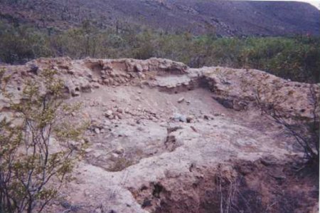
This was the largest room, in the middle of the long building ruins. This visita served Mision San Fernando in the early 1800's. (7-25-00)
A room dividing wall. Beyond note the square pits which were rooms in this long building. Picture facing NNW, note some of the date palms near the
arroyo and pools. Adobe is built on stone foundation. Some plaster/ paint is visible on inside walls!
[Edited on 3-7-2007 by David K]
woody with a view - 3-5-2007 at 08:35 PM
what could they possibly be growing out there? i guess there is water nearby? bad day....
David K - 3-5-2007 at 09:15 PM
In case anyone wanted to know, who didn't... San Juan de Dios is the the middle of Baja between El Rosario and Puertecitos.
Junipero Serra, on his long walk from Loreto to San Diego stopped there and had his swollen left leg treated by a muleteer with the same poultice used
to treat mules... It worked!
The site became a Dominican visita of the mission of San Fernando...
Note arrow...

David K - 3-5-2007 at 09:21 PM
Close up

David K - 3-5-2007 at 09:22 PM
El Metate is the original home of Mama Espinoza... It was her son, Sony Espinoza who showed me where the ruins were... He was grading the road in from
Hwy. 1 in 2000.
BAJACAT - 3-5-2007 at 09:35 PM
very sad in dee I guess I will never will be able to see it in person,their here one day gone the next.
David K - 3-5-2007 at 10:29 PM
So true... the adobe missions sites are fading away fast... See http://vivabaja.com/bajamissions
PabloS - 3-6-2007 at 11:16 AM
Probably another "Cilantro" farm what a shame
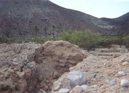
Jack Swords Photos from Nov. 12, 2003
David K - 3-7-2007 at 10:46 AM
Here are 4 photos taken at San Juan de Dios by Jack Swords (reduced to post on Nomad)...

David K - 3-7-2007 at 10:47 AM
another...

David K - 3-7-2007 at 10:48 AM
note palms in background... they are along the river.

David K - 3-7-2007 at 10:50 AM
If what Neal reported is correct, then another mission-era site is lost forever...

Can only hope he is mistaken
DianaT - 3-7-2007 at 10:55 PM

Diane
David K - 3-13-2007 at 08:10 AM
Neal, John M... You guys back yet???
Neal Johns - 3-13-2007 at 04:01 PM
We are back.
Here is the picture where the new field about the size of a football field was bulldozed into being. The picture was taken from the middle of the
field. Great rows of vegetation were piled up. Compare with DK's picture.
.jpg - 47kB")
Neal Johns - 3-13-2007 at 04:11 PM
We think maybe this project (whatever it is) might have had something to do with it. These signs were posted at all turns to San Juan de Dios.

Mexitron - 3-13-2007 at 04:16 PM
That doesn't seem to be the best agricultural soil there, at least if recall the few times I've visited the site. pretty rocky--nothing like just
east at R. El Metate. Maybe they're putting in more ranch structures? There were some existing structures there although whether they were being used
I don't recall.
Neal Johns - 3-13-2007 at 04:48 PM
There is a shack there now, but not presently lived in. Plenty of water but little flat cleared land.
A mile or so down the road toward El Metate, there are two adobes, a well, a large crypt with at least two graves in it and plenty of flat land. We
walked across the flood plain and found running water on the far side. You saw this and took pics, DK, it sure looks more like a mission/visita site
than the first water crossing where the adobe was bulldozed. What say, DK?
Poor pic of crypt:

Mexitron - 3-13-2007 at 05:33 PM
UMA-Baja it would seem has something to do with protecting things in Baja:
http://www.bajacalifornia.gob.mx/ecologia/tramites/tasas.htm
David K - 3-13-2007 at 06:07 PM
That sounds like a typical government project : Destroy it first, then protect it!!!
David K - 3-13-2007 at 06:10 PM
Neal, I never saw the crypt... the visita site was pointed out by Sony Espinoza who was camping there with family while he was road building. Also, I
saw an INAH site plan and it matched the site.
Please describe where the crypt was... I did go to the adobe ruins that Jack Swords 'found'... They are about a mile from the visita... northeast...
just north from the road to El Metate.
More photos of the area, too... PLEASE!
Another view of what appears to be a burial crypt
John M - 3-13-2007 at 06:28 PM
attached.
John M

Stream
John M - 3-13-2007 at 06:37 PM
This is the current view of the San Juan de Dios streambed within approximately 300 yards of what Jack Sword has referred to as the San Juan de Dios
adobe ruins.
The streambed at this point is favorably similar to that described by Fr. Crespi in March 1769 "...There are many willows and cottonwoods in the bed
of this stream, several large pools of good water and much fine grass. Our Indians went out ahead and brought back a heathen who was still a boy,
naked and heavily painted in stripes; and a soldier gave him a lighted cigar, which he smoked with great address."
Quote is from Gateway to Alta California by Harry Crosby.
We did not see the heathen, nor the remains of the cigar.
John M
[Edited on 3-14-2007 by John M]

Neal Johns - 3-13-2007 at 06:52 PM
From the adobes, the crypt is on top of a small hill/mesa 100 yards toward the bulldozed site and 50 yards from the new road (in a direction further
away from Arroyo San Juan de Dios)). I am Directionally Challenged around there. As you can see, there is a rock wall around it. I thought it was a
corral before I checked it out. There are some Indian rock circles on the mesa behind the crypt. There are two adobes, one on either side of the new
road. According to my GPS, the old road is the one parallel and 0.2 miles further away (and higher) from the Arroyo.
Maybe John M. can post some pics, My camera hates me and screwed up. I take no responsibility for anything. 

Neal Johns - 3-13-2007 at 07:36 PM
Here is the "new" shack at the bulldozed site:

Jack Swords - 3-13-2007 at 09:04 PM
Interesting! The adobes and "crypt" were past the supposed location of SJDD on the other side of the hill. That is where the stream was too. The
supposed location of SJDD was in the clearing where the grove of date palms are/were. Passing up the hill past the date palm grove, to the right in
brush, was where the SJDD ruins were photographed. Now, once up over the hill you encounter the adobe ruins, still some walls, some adobe mounds, and
the crypt, and an horno where it appears white material was fired (mortar?). The stream was there, water, etc. It appears that a return trip is
needed to ascertain what is happening and where.
Map of SJDD area
David K - 3-13-2007 at 10:49 PM
To help visualize these places, I sketched two maps to help...
John, the photo of you with the palms behind look (to me) to be too close to the palms... The visita was on the south side of the road to El Metate,
uphill from the river crossing.
The road (then) crossed the river and curved slightly to the north as it heads eastward... passes a branch north into the palm grove area...
The visita site could NOT be seen from the road as it was hidden by brush... However, the north end of the visita was only 20-30 feet from the road!
The visita was about 90 feet long and ran north/south.
[Edited on 3-14-2007 by David K]

David K - 3-13-2007 at 10:51 PM
Here's one a bit further out... The distance from San Juan de Dios (Palms/ Visita) to El Metate is 2.5 miles.
[Edited on 3-14-2007 by David K]

My sketch
John M - 3-14-2007 at 04:14 AM
David and Jack and others....
Here is my sketch using David K's as a base.
The plowed & cleared area, in my estimation, extends both north and south of the road to a distance of perhaps 300 feet, possibly a little more to
the north of the road. The cleared area also extends a similar distance to the east.
I'm not certain of the compass direction at the site so I am using the compass directions indicated by David - I believe them to be correct.
We had with us a copy of the visita ruins photograph David K had taken. Neal lined up the palms, rocks in the mountainside behind the palms in several
places to establish what we believe to be the same relationship as in the David K photograph. Where Neal stood to take the photograph is very close to
where David K took his photo, even though the photo posted may not look so exact. We were quite careful to line up several things to make an accurate
photo comparison.
Sadly this was in the MIDDLE of the cleared area. The cleared area extended another hundred feet or so behind and to the south where Neal stood to
take the photo.
More later today.
John M
[Edited on 3-14-2007 by John M]

surfer jim - 3-14-2007 at 07:24 AM
I did a google search for "uma baja" there is some info....in spanish....some govt. agency it sounds like.....maybe someone can translate......
Neal Johns - 3-14-2007 at 06:38 PM
Any translators out there? Just put "UMA Baja" into Google or any other search engine and you get a whole bunch of Spanish websites. Apparently they
are concerned with plants.
translation help from FDT
John M - 3-14-2007 at 06:51 PM
I asked on another thread about the sign and FDT answered with this, and the next post as well.
John M
UMA = Unidad de Manejo para la conservacion de la vida silvestre
It is a program in place by the state of Baja California with SEMARNAT.
That particular sign has the number of a location.
Second reply from FDT on translation of sign
John M - 3-14-2007 at 06:52 PM
This also from FDT:
here is alink I found
http://www.discoverbajacalifornia.com/hunting/umas.htm
David K - 3-14-2007 at 07:07 PM
Too bad they destroy an irreplaceable mission site to build a hunting lodge... or whatever!
Are you guys going to enlighten us with the rest of your trip? Enquiring minds need to know! Canelo wash, La Turquesa canyon, etc... 
Mexitron - 3-14-2007 at 08:28 PM
David K--I tried finding the adobe and crypt on Google Earth--they show the aforementioned bulldozed sight before being razed but the pixels get
blurry in the next frame where the adobe and crypt are...bummer...maybe someone has a better version of Google Earth(?)...Taco de Baja?
David K - 3-15-2007 at 08:21 AM
Edge of high resolution ends just at the edge of the visita, which you can see from space!