BajaNomad

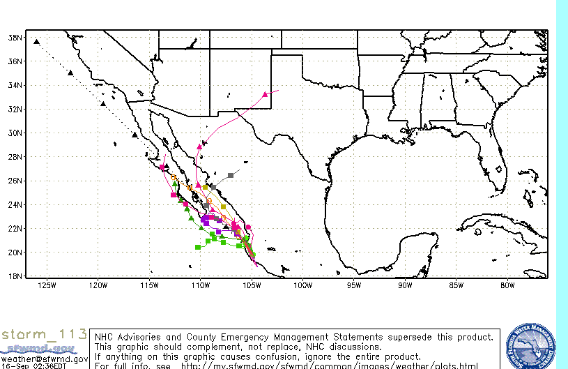
Hurricane Manuel takes aim at the mainland

bajajudy - 9-13-2013 at 01:55 PM

TROPICAL STORM MANUEL DISCUSSION NUMBER 2
NWS NATIONAL HURRICANE CENTER MIAMI FL EP132013
200 PM PDT FRI SEP 13 2013

VISIBLE SATELLITE IMAGES SHOW THAT THE CYCLONE IS A LITTLE FARTHER
WEST THAN ESTIMATED EARLIER THIS MORNING...WITH A GROWING BALL OF
CONVECTION NEAR THE CENTER. ASCAT DATA SUGGESTED THE MAXIMUM WINDS
WERE ABOUT 35 KT...AND THIS IS USED AS THE INITIAL INTENSITY.
WHILE THE AREA OF TROPICAL-STORM-FORCE WINDS IS SMALL...THE
CIRCULATION OF MANUEL IS EMBEDDED WITHIN A MUCH LARGER CYCLONIC
GYRE THAT CONTAINS LOTS OF STRONG WINDS NOT DIRECTLY ASSOCIATED WITH
THE TROPICAL CYCLONE. THIS STRUCTURE MAKES THE INTENSITY FORECAST
TRICKY SINCE OTHER ENVIRONMENTAL FACTORS SEEM CONDUCIVE FOR
STRENGTHENING. GIVEN THE RELATIVELY SMALL RADIUS OF MAXIMUM WINDS
FROM ASCAT...MANUEL SHOULD HAVE A GOOD CHANCE TO INTENSIFY...AND
THE NHC PREDICTION IS A LITTLE ABOVE THE CONSENSUS AT THE UPPER END
OF THE GUIDANCE SPECTRUM.

INSTEAD OF A TURN TOWARD THE NORTH-NORTHWEST OCCURRING...IT SEEMS
LIKE MANUEL IS HEADING WEST-NORTHWESTWARD...295/5. MOST OF THE
GUIDANCE STILL SUGGEST THE STORM SHOULD TAKE A NORTHWARD TURN
RELATIVELY SOON DUE TO THE RIDGE WEAKENING OVER MEXICO. HOWEVER...
THE MODEL SPREAD HAS GROWN SINCE THE LAST ADVISORY...WITH THE
NORMALLY RELIABLE ECMWF A FAIR DISTANCE WEST OF THE MODEL
CONSENSUS. THIS IS NOT A HIGH CONFIDENCE FORECAST WITH THE GLOBAL
MODELS STRUGGLING TO RESOLVE THE INTERACTION OF THE RIDGE OVER
MEXICO...AN UPPER-LEVEL LOW...AND TROPICAL STORM INGRID. THE NEW
NHC TRACK FORECAST IS SHIFTED WESTWARD...ABOUT MIDWAY BETWEEN THE
ECMWF AND THE MODEL CONSENSUS...AND IT WOULD NOT BE VERY SURPRISING
IF FURTHER WESTWARD ADJUSTMENTS ARE REQUIRED.

FORECAST POSITIONS AND MAX WINDS

INIT 13/2100Z 15.6N 102.1W 35 KT 40 MPH
12H 14/0600Z 16.0N 102.3W 45 KT 50 MPH
24H 14/1800Z 16.8N 102.4W 50 KT 60 MPH
36H 15/0600Z 17.9N 102.7W 50 KT 60 MPH
48H 15/1800Z 18.9N 103.2W 30 KT 35 MPH...INLAND
72H 16/1800Z...DISSIPATED

[Edited on 9-15-2013 by bajajudy]

[Edited on 9-17-2013 by bajajudy]

[Edited on 9-19-2013 by bajajudy]

bajajudy - 9-15-2013 at 04:46 PM

The fat lady hasn't sung yet

THE INITIAL MOTION ESTIMATE IS 320/08. MANUEL CONTINUES TO BE
STEERED TOWARD THE NORTHWEST BY A LARGE MID-LEVEL RIDGE LOCATED
OVER THE CENTRAL U.S. GULF COAST. THE MODELS ARE IN GOOD AGREEMENT
THAT THIS GENERAL MOTION WILL CONTINUE WHILE THE CIRCULATION
REMAINS INTACT. THERE IS SOME DISCREPANCY BEYOND 24 HOURS AND SOME
MODELS...NOTABLY THE HWRF...GFDL...AND ECMWF...SHOW A TRACK TOWARD
THE BAJA CALIFORNIA PENNISULA. HOWEVER...THIS SCENARIO IS BEING
DISCOUNTED FOR NOW SINCE THE VORTEX TRACKER APPLIED TO THESE MODELS
SEEMS TO FOLLOW ANOTHER AREA OF LOW PRESSURE WHILE MANUEL
DISSIPATES.

chippy - 9-15-2013 at 05:05 PM

ManWell was a big dud. Gracias adios!

comitan - 9-15-2013 at 06:17 PM

I trust the GFDL track no matter what they say.

Looks like Manuel could sneak in the backdoor

monoloco - 9-15-2013 at 11:43 PM


stanburn - 9-16-2013 at 05:44 AM

Well he came ashore yesterday here in Manzanillo and Manuel was quite the non event. No wind and not that much rain. So far I have only recorded 1.5".

Stan

bajajudy - 9-16-2013 at 10:05 AM

Starting to get some of Manuel's clouds.
We are keeping an eye on it. Can't help but think of Juliette which formed very rapidly close to this same location and brought us, not only a lot of rain, but also 45mph winds.

[Edited on 9-16-2013 by bajajudy]

DENNIS - 9-16-2013 at 10:47 AM

Doesn't look like Manuel is going to amount to much:

http://www.cyclocane.com/hurricane-forecast/

shari - 9-16-2013 at 10:59 AM

yes Judy...it's good to keep alert...one thing baja teaches us is to expect the unexpected!

DavidE - 9-16-2013 at 12:38 PM

Where does one keep a lert? According to some folks maintaining a lert is tiring as can be.

Lertus Pharmacology

toneart - 9-16-2013 at 01:35 PM

Quote:
Originally posted by DavidE
Where does one keep a lert? According to some folks maintaining a lert is tiring as can be.


Lertus Pharmacology
Latanoprost is an isopropyl ester prodrug which is inactive but which becomes active after hydrolysis...:o Uhhh, Manuel is full of H2O. :wow:

bajajudy - 9-17-2013 at 11:16 AM

Found the lert


000
ABPZ20 KNHC 171729
TWOEP

TROPICAL WEATHER OUTLOOK
NWS NATIONAL HURRICANE CENTER MIAMI FL
1100 AM PDT TUE SEP 17 2013

FOR THE EASTERN NORTH PACIFIC...EAST OF 140 DEGREES WEST LONGITUDE..

AN AREA OF LOW PRESSURE...ASSOCIATED WITH THE REMNANTS OF
MANUEL...IS LOCATED ABOUT 60 MILES NORTHWEST OF THE ISLAS MARIAS.
SHOWER AND THUNDERSTORM ACTIVITY ASSOCIATED WITH THIS SYSTEM HAS
BECOME BETTER ORGANIZED TODAY AND ADDITIONAL DEVELOPMENT IS LIKELY
DURING THE NEXT COUPLE OF DAYS WHILE IT MOVES SLOWLY NORTHWESTWARD.
THIS SYSTEM HAS A HIGH CHANCE...60 PERCENT...OF BECOMING A TROPICAL
CYCLONE AGAIN DURING THE NEXT 48 HOURS. AFTER THAT TIME...THE
CLOSE PROXIMITY TO LAND AND COOLER WATERS ARE EXPECTED TO INHIBIT
FURTHER DEVELOPMENT...AND THIS SYSTEM ALSO HAS A HIGH CHANCE...60
PERCENT...OF BECOMING A TROPICAL CYCLONE DURING THE NEXT 5 DAYS.
INTERESTS ALONG THE WEST-CENTRAL COAST OF MEXICO AND IN SOUTHERN
BAJA CALIFORNIA SHOULD MONITOR THE PROGRESS OF THIS LOW.

&&
FIVE-DAY FORMATION PROBABILITIES ARE EXPERIMENTAL IN 2013. COMMENTS
ON THE EXPERIMENTAL FORECASTS CAN BE PROVIDED AT...

WWW.NWS.NOAA.GOV/SURVEY/NWS-SURVEY.PHP?CODE=ETWO

$$
FORECASTER BROWN

CaboMagic - 9-17-2013 at 01:25 PM

Judy love your humor :-) thanks for that

btw the Port Captain closed the Port after many/most boats left this morning .. & will issue notice later about tomorrow ..

DavidE - 9-17-2013 at 02:04 PM

Life Without Laughter Is Painful...

Can "Manuel" Get His --- Together? Before entering cooler water?

Can the maid make it past the suspicious wife of the patron without causing a catfight while avoiding pregnancy? Stay tuned to Los Prognosticos and the hot novela to find the answer to these and other mysteries.

Manuel better have one full head of hair as upper atmosphere wind shear is trying to separate his head from his neck.

Topics In The Tropics

comitan - 9-17-2013 at 02:33 PM

David

Head or no head Manuel is going to bring is rain Probably Thursday and I don't think it will go north to affect Mulege so we will enjoy.

bajajudy - 9-17-2013 at 03:15 PM

A lot of information here

http://www.bajainsider.com/weather/hurricanes/2013/hurricane...

[Edited on 9-17-2013 by bajajudy]

pauldavidmena - 9-17-2013 at 03:59 PM

Looks like Manuel will strengthen from Tropical Depression to Tropical Storm as it heads back into the Pacific. Current models project its path into the Sea of Cortez, but it's too early to tell - on the other hand, it's also too early to declare the storm "done".

DavidE - 9-17-2013 at 04:36 PM

With a little luck, rainfall on the tip might approach normal levels. Manuel won't reach hurricane status due to less than "ideal" conditions for formation. Aquifers need to be replenished the best they can. After all it's Baja California and not an air conditioned shopping mall. The farmers in Constitucion may end up dancing with glee at this.

BajaNomad - 9-17-2013 at 11:51 PM

Quote:
Originally posted by pauldavidmena
Looks like Manuel will strengthen from Tropical Depression to Tropical Storm as it heads back into the Pacific.


AT 1100 PM PDT...0600 UTC...THE CENTER OF TROPICAL DEPRESSION MANUEL
WAS LOCATED NEAR LATITUDE 23.1 NORTH...LONGITUDE 107.6 WEST. MANUEL
HAS NOT MOVED MUCH OVER THE PAST COUPLE OF HOURS...BUT A MOTION
TOWARD THE NORTHWEST AT AROUND 6 MPH...9 KM/H...IS EXPECTED TO
RESUME OVERNIGHT AND CONTINUE FOR THE NEXT DAY OR TWO. ON THE
FORECAST TRACK...THE CENTER OF MANUEL IS FORECAST TO REMAIN WEST OF
THE WEST-CENTRAL COAST OF MEXICO DURING THE NEXT 24 HOURS...AND
THEN APPROACH THE EAST COAST OF THE SOUTHERN BAJA CALIFORNIA
PENINSULA LATE WEDNESDAY NIGHT OR THURSDAY.

MAXIMUM SUSTAINED WINDS ARE NEAR 35 MPH...55 KM/H...WITH HIGHER
GUSTS. GRADUAL STRENGTHENING IS FORECAST DURING THE NEXT 48
HOURS...AND MANUEL IS EXPECTED TO BECOME A TROPICAL STORM AGAIN ON
WEDNESDAY.

11pm-Tuesday.jpg - 50kB

It's about the critters

DaliDali - 9-18-2013 at 12:58 AM

Quote:
Originally posted by DavidE
With a little luck, rainfall on the tip might approach normal levels. Manuel won't reach hurricane status due to less than "ideal" conditions for formation. Aquifers need to be replenished the best they can. After all it's Baja California and not an air conditioned shopping mall. The farmers in Constitucion may end up dancing with glee at this.


I like the critters...coyotes, rabbits, deer, foxes, quail and roadrunners.
Critters need rain to make their food sources thrive.....and so then the critters survive.
No rain...fewer critters....not good.

In the end......rain baby rain.

bajajudy - 9-18-2013 at 07:27 AM

Just started raining here....light, no wind
Dark.

Bill Collector - 9-18-2013 at 07:38 AM

Started raining about 6 here. Surf is picking up, high tide is 9:30

chuckie - 9-18-2013 at 07:45 AM

Some blackish clouds passed over Mulege.....

bajajudy - 9-18-2013 at 07:54 AM

Manuel just became a tropical storm!

chuckie - 9-18-2013 at 08:14 AM

We wouldnt have had any problem if people hadnt made him angry by saying he was dead....

Tomas Tierra - 9-18-2013 at 08:18 AM

Hopefully a light but steady rain maker... And that's it! Stay safe...

Bill Collector - 9-18-2013 at 08:23 AM

It's raining harder right now than any of the other other storms. Very little wind, that's a positive. The sea is really getting ugly...lets hope we keep power.

DavidE - 9-18-2013 at 09:18 AM

Let those rockbound tinacas fill!

Up on the Vizcaino peninsula, all those inches of rainfall we got have disappeared hopefully mostly into the ground. If Manuelito soaks the Cd Constitucion area really well the grocery markets are going to see the results in a month or two. A virtual horn of plenty of veduras y frutas regionales. The mango and orange groves of los comondu's are going to take a long, slow satisfying drink. This is the manguero in me talking. Manuelito will not be enough, more rainfall is needed. Abejas Africanizados thrive when drought hammers at domestic bee colonies.
Plentiful rain affects a lot of the biosphere balance, than umbrella sales.

redmesa - 9-18-2013 at 09:25 AM

I wonder how many inches of rain Mulege, Loreto, Cabo, etc.have actually received this year to date.

BajaRat - 9-18-2013 at 09:35 AM

Time for the elusive SOC surf spots to come to life.
Hope you all stay safe. :cool:

monoloco - 9-18-2013 at 10:27 AM

Quote:
Originally posted by redmesa
I wonder how many inches of rain Mulege, Loreto, Cabo, etc.have actually received this year to date.
Here in Pescadero, we have received 3.24" so far this summer.

Drive extra carefully, folks.

Mulegena - 9-18-2013 at 10:45 AM

Down south of Loreto just last week there were waterfalls!

Really.
Truly.
Waterfalls!

I drove my little pickup through two flooding arroyos after waiting an hour or so for them to recede. If this storm brings much rain, these arroyos will flood again. They are just north of the turnoff to Puerto Escondido. Also watch for rockslides in the mountains south of Loreto, and be aware the highway bridge is washed out and there are road repair crews.

It's so darned green and gorgeous right now your eye will tend to wander.

Beware that the highway south of Loreto is still chewed up and will remain so for a long time. There are no written signs of warning: look carefully for the thin placards on the side of the highway that are the only indication of areas of great concern. These placards are about 10"wide and 5 feet tall with diagonal black and orange stripes. They may be placed before an area of road damage or you won't encounter them until you're on top of the area. All the warning you're gonna get. Be sure to drive slowly and use your headlights at all times; flash your hazard blinkers to warn oncoming traffic when necessary. Stay safe, travelers.

bajajudy - 9-18-2013 at 11:21 AM

Starting to look like the mainland is going to catch the brunt of this storm which they are saying may be a hurricane when it touches land.

Still dark here, very little rain, no wind.

DavidE - 9-18-2013 at 11:45 AM

Tiny extremely intense hurricanes can form. But they are rare. They need to be nurtured under damned near lab grade controlled conditions. I believe mainland mountains make the odds against rise from a thousand to one to millions to one as compared to conditions in the open Atlantic.

But a tiny category V event traveling the full length of the gulf is a scary thought. A monster V coming up the west coast would be just as frightening. My new casita has 1/8" steel shutters and door, foot thick six-sack concrete walls and roof, is built on rock and has no hillside near and a deep and wide arroyo alongside dumping into the ocean. The patio and porch has a 3% drain grade. Same for the first 18" inside the front door.

DavidE - 9-18-2013 at 01:46 PM

GOOD OL CORIOLIS AT WORK. Latest Discussion...

MANUEL CONTINUES MOVING A LITTLE TO THE RIGHT OF THE EARLIER
FORECAST. THE LATEST NHC OFFICIAL FORECAST HAS BEEN ADJUSTED
EASTWARD AND NOW SHOWS MANUEL MOVING VERY CLOSE TO THE COAST OF
MAINLAND MEXICO IN 24 TO 36 HOURS. THIS IS SIMILAR TO THE 12Z GFS
THAT NOW TAKES MANUEL INLAND OVER MAINLAND MEXICO IN A DAY OR SO.
ADDITIONAL CHANGES TO THE TRACK FORECAST COULD BE REQUIRED IF SOME
OF THE OTHER RELIABLE GUIDANCE SHIFTS EASTWARD LATER TODAY.

THIS SPECIAL ADVISORY IS IN LIEU OF THE 1800 UTC INTERMEDIATE
ADVISORY.

FORECAST POSITIONS AND MAX WINDS

INIT 18/1800Z 23.6N 107.9W 50 KT 60 MPH
12H 19/0000Z 24.0N 108.2W 55 KT 65 MPH
24H 19/1200Z 24.6N 108.5W 60 KT 70 MPH
36H 20/0000Z 25.2N 108.6W 60 KT 70 MPH
48H 20/1200Z 25.2N 108.9W 50 KT 60 MPH
72H 21/1200Z 24.9N 109.5W 40 KT 45 MPH
96H 22/1200Z 24.0N 110.8W 25 KT 30 MPH...POST-TROP/REMNT LOW
120H 23/1200Z...DISSIPATED

$$
FORECASTER BROWN

BajaNomad - 9-18-2013 at 01:56 PM

AT 200 PM PDT...2100 UTC...THE CENTER OF TROPICAL STORM MANUEL WAS
LOCATED NEAR LATITUDE 23.9 NORTH...LONGITUDE 108.1 WEST. MANUEL IS
MOVING TOWARD THE NORTH-NORTHWEST NEAR 5 MPH...7 KM/H...AND THIS
GENERAL MOTION IS EXPECTED TO CONTINUE THROUGH THURSDAY. ON THE
FORECAST TRACK...THE CENTER OF MANUEL WILL APPROACH THE WEST-
CENTRAL COAST OF MEXICO WITHIN THE HURRICANE WATCH AREA THURSDAY
AFTERNOON.

SATELLITE DATA INDICATE THAT THE MAXIMUM SUSTAINED WINDS HAVE
INCREASED TO NEAR 70 MPH...110 KM/H...WITH HIGHER GUSTS.
ADDITIONAL STRENGTHEN IS FORECAST AND MANUEL IS EXPECTED TO
BECOME A HURRICANE LATER TODAY.

manuel-2pm-Wednesday.jpg - 49kB

woody with a view - 9-18-2013 at 02:59 PM

in surfing parlance, this is a blue moon storm. we get this trajectory once or twice a decade and the waves are PUMPED up the gulf to places which may only break once in a lifetime. i know a guy who used to talk about these type storms....

start the dreaming!

The end run

DaliDali - 9-18-2013 at 03:07 PM

Quote:
Originally posted by DavidE
GOOD OL CORIOLIS AT WORK.


Mother nature will have the last say. just sayin.

chuckie - 9-18-2013 at 03:08 PM

She always does.....

bajajudy - 9-18-2013 at 03:24 PM

Pouring here now with thunder and lightening.
Looks like it will not make it to Baja
Note 85mph winds


000
WTPZ43 KNHC 182047
TCDEP3

TROPICAL STORM MANUEL DISCUSSION NUMBER 18
NWS NATIONAL HURRICANE CENTER MIAMI FL EP132013
200 PM PDT WED SEP 18 2013

THE INNER-CORE STRUCTURE OF MANUEL HAS CONTINUED TO IMPROVE WITH A
WELL-DEFINED EYE FEATURE NOTED IN THE LASTEST MICROWAVE IMAGES. A
RAGGED EYE HAS ALSO RECENTLY APPEARED IN VISIBLE STATELLITE
PICTURES. THE LATEST DVORAK T-NUMBERS ARE 3.0 FROM BOTH TAFB AND
SAB AND 3.4 FROM UW/CIMSS ADT. THE INITIAL INTENSITY IS RAISED
TO 60 KT...A LITTLE ABOVE THESE ESTIMATES...BASED ON THE IMPROVED
SATELLITE PRESENTATION DURING THE PAST COUPLE OF HOURS. GIVEN THE
CONDUCIVE ENVIRONMENTAL FACTORS OF LOW SHEAR AND WARM WATER...
MANUEL IS EXPECTED TO CONTINUE INTENSIFYING DURING THE NEXT DAY
OR SO. AFTER THAT TIME...THE INNER CORE IS EXPECTED TO INTERACT
WITH LAND WHICH WILL LIKELY CAUSE WEAKENING. SINCE THE NEW NHC
FORECAST SHOWS MANUEL NEARING THE COAST OF MAINLAND MEXICO AS A
HURRICANE...A HURRICANE WARNING HAS BEEN ISSUED FOR A PORTION OF
THE COAST OF WEST-CENTRAL MEXICO.

THE STORM IS MOVING NORTH-NORTHWEST AT ABOUT 4 KT. THE DYNAMICAL
MODEL GUIDANCE HAS SHIFTED EASTWARD AND COME INTO SOMEWHAT BETTER
AGREEMENT ON A TRACK NEAR OR OVER THE COAST OF MAINLAND MEXICO. THE
GFS SHOWS LANDFALL IN 24 TO 36 HOURS...ALTHOUGH THE HWRF IS FASTER
TO THE COAST. THE ECMWF TAKES MANUEL TO THE COAST BEFORE IT TURNS
WESTWARD. THE NHC TRACK HAS BEEN SHIFTED EASTWARD ONCE AGAIN AND IS
CLOSE TO THE MODEL CONSENSUS THROUGH 24 HOURS. AFTER THAT
TIME...THE OFFICIAL FORECAST SHOWS MANUEL TURNING WESTWARD AT THE
COAST...OUT OF RESPECT FOR THE MODELS THAT KEEP THE CYCLONE
MEANDERING OFFSHORE. MODEL TRENDS...HOWEVER...SUGGEST THAT FURTHER
EASTWARD SHIFTS ARE LIKELY.

BECAUSE OF THE ANGLE OF APPROACH OF MANUEL TO THE COASTLINE OF
MAINLAND MEXICO...THERE IS A LARGE UNCERTAINTY AS TO WHERE AND WHEN
WITHIN THE WARNING AREA THE HURRICANE-FORCE WINDS WILL REACH THE
COAST. RESIDENTS WITHIN THE ENTIRE HURRICANE WARNING AREA SHOULD
PREPARE FOR HURRICANE CONDITIONS.

FORECAST POSITIONS AND MAX WINDS

INIT 18/2100Z 23.9N 108.1W 60 KT 70 MPH
12H 19/0600Z 24.5N 108.4W 70 KT 80 MPH
24H 19/1800Z 25.0N 108.5W 75 KT 85 MPH
36H 20/0600Z 25.3N 108.6W 70 KT 80 MPH...NEAR THE COAST
48H 20/1800Z 25.4N 108.8W 55 KT 65 MPH...NEAR THE COAST
72H 21/1800Z 25.4N 109.0W 35 KT 40 MPH...NEAR THE COAST
96H 22/1800Z 25.4N 109.0W 25 KT 30 MPH...POST-TROP/REMNT LOW
120H 23/1800Z...DISSIPATED

$$
FORECASTER BROWN

[Edited on 9-18-2013 by bajajudy]

bajajudy - 9-18-2013 at 05:50 PM

From NHC Adv #18


DISCUSSION AND 48-HOUR OUTLOOK
------------------------------
AT 500 PM PDT...0000 UTC...THE RAGGED EYE OF HURRICANE MANUEL WAS
LOCATED NEAR LATITUDE 24.3 NORTH...LONGITUDE 108.0 WEST. MANUEL IS
MOVING TOWARD THE NORTH NEAR 5 MPH...7 KM/H...AND THIS GENERAL
MOTION IS EXPECTED TO CONTINUE TONIGHT AND EARLY THURSDAY. ON THE
FORECAST TRACK...THE CENTER OF MANUEL WILL BE NEAR OR OVER THE WEST-
CENTRAL COAST OF MEXICO WITHIN THE HURRICANE WARNING AREA THIS
EVENING.

VISIBLE SATELLITE IMAGES INDICATE THAT MANUEL IS NOW A HURRICANE.
MAXIMUM SUSTAINED WINDS ARE NEAR 75 MPH...115 KM/H...WITH HIGHER
GUSTS. SOME SLIGHT STRENGTHENING IS POSSIBLE BEFORE THE HURRICANE
MOVES INLAND.

MANUEL IS A SMALL HURRICANE...AND THE HURRICANE FORCE WINDS EXTEND
OUTWARD TO 20 MILES...30 KM FROM THE CENTER. TROPICAL STORM FORCE
WINDS EXTEND OUTWARD UP TO 45 MILES...75 KM FROM THE CENTER.

THE ESTIMATED MINIMUM CENTRAL PRESSURE IS 987 MB...29.15 INCHES.

BajaNomad - 9-18-2013 at 07:29 PM

latest...

manuel-wed-7pm.jpg - 49kB

Lauriboats - 9-19-2013 at 07:28 AM

My local news this morning, so sad.


News10 Sacramento


Hurricane Manuel has killed 80 people and is now moving up Mexico's Pacific coast, bringing along with it evacuations, looting and incredible flooding. These pictures show the extreme levels to which the water has risen.

STORY & GALLERY: http://on.news10.net/1fbOd9l


[Edited on 9-19-2013 by Lauriboats]

DavidE - 9-19-2013 at 10:18 AM

Looters carried massive flat screen televisions, stereos, and even stainless steel barbecues from the big Costco store on ave Costera.

The cops should have emptied their automatic weapons into them, and let folks carrying sacks of beans and rice, food stuffs pass.

I get bad vibes when I must travel and shop in Acapulco.

This is the same type of attitude that has a macho spending every dime he has on a massive stereo system for his peeckup and then not giving a damn about driving around with one headlight and no rear lights whatsoever. They'll spend THOUSANDS of pesos for cerveza and then conveniently forget about their debts.

Equal opportunity griping :)

monoloco - 9-19-2013 at 11:04 AM

Quote:
Originally posted by DavidE
Looters carried massive flat screen televisions, stereos, and even stainless steel barbecues from the big Costco store on ave Costera.

There's no sense in letting a good disaster go to waste.

DavidE - 9-19-2013 at 12:48 PM

Yeah! A real moving target can't be beat for authenticity. Cops lined up...

A shot is fired

Arms rise holding signs

8.5, 8.0, 8.0, 8.5, 9.0

Highest and lowest scores are thrown out.

toneart - 9-19-2013 at 04:37 PM

While it is still a threat, any local reports on Hurricane Manuel's impact on Baja would be appreciated, even if it turns out to be a non-event.

I hope it spares the state of Colorado too. They don't need any more flooding. Stay safe.

Thank you.

bajajudy - 9-19-2013 at 06:14 PM

Quote:
Originally posted by toneart
While it is still a threat, any local reports on Hurricane Manuel's impact on Baja would be appreciated, even if it turns out to be a non-event.

I hope it spares the state of Colorado too. They don't need any more flooding. Stay safe.

Thank you.

We had some rain,no wind.
I believe that he totally missed Baja

mulegemichael - 9-19-2013 at 07:08 PM

ohhhh...david e...how racist can you get???....so none of your whitey guys do the same thing???/....oh my...why do you live in baja?...geez man, that is really really a weird, thing to say...and i'm not a tree hugger...for the most part.

mulegemichael - 9-19-2013 at 07:12 PM

oh by the way, david e, ever been in l.a. during stressful times?...i think we saw a lot of that going on up there and they weren't necessarily mexican "machos"...what a strange, narrow, slanted, view on what's going on during stressful times down here.

Mulegena - 9-19-2013 at 10:27 PM

Yes, poor Mainland Mexico is stressed beyond its capability to cope and meet the rescue need efforts.

Food and water are being airlifted in as access to helicopters permits. One helicopter crashed, its pilot and co-pilot are still missing.

Thirst & hunger, stress emotional and physical take a toll very quickly. If there's been looting it's been primarily of food and water; anything else, well, so be it.

There's standing brown water everywhere and more rain expected. People are living in it; kids are swimming in it! The Mexican national evening news is devoted to covering the flooding with on-site reporting in each affected state. It hasn't been addressed by news coverage yet, but my fear, cholera.

Needless to say, the magnitude of this national state of emergency makes the problems that Mulege faces and has faced in years past seem small and insignificant.

Here's a link: http://www.bbc.co.uk/news/world-latin-america-24170297

Donations for emergency relief efforts are being requested.
I'll see if I can find the contact information and I'll post.

DavidE - 9-20-2013 at 09:11 AM

It is amazing that the USA will give away billions of dollars in bullets, bombs, and mines, yet fore go acting to save lives and improve our image in Mexico. A ship loaded with staples would cost millions of dollars to send to Acapulco. Supervision would be needed by the military to ensure some Mexico rico would not steal the cargo and then sell it. But it could be done. Bags of arroz, frijols, and masa stamped in Spanish, "From Your Friends In The EUA" would do more for bettering relations than anything I can think of. Then again, such action would probably start a stock market speculative effort where people could bet against it.