BajaNomad

Vizcaino shortcut idea?

geoffff - 1-25-2016 at 09:19 PM

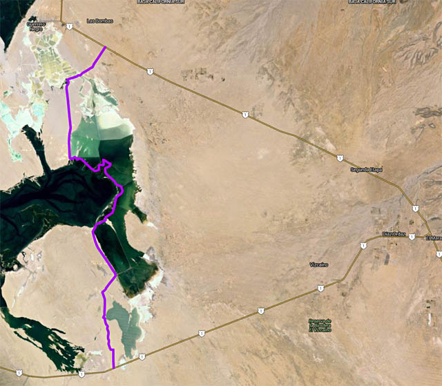
I know it wouldn't actually save me any time, but does anyone know if the public is allowed to drive through salt areas south of Guerrero Negro? I'm looking for a "shortcut" to the Bahia Tortugas road -- to bypass having to drive all the way to the Vizcaino intersection on Hwy 1, and then go back east. My idea is to drive south to the whale campground on Estero Norte, and then try continuing south like this:


(Google Maps link)

The Baja Almanac says the salt areas just southwest of Guerrero Negro town are private/no access, but doesn't say anything about the "salinos" southeast of town and east of Laguna Ojo de Liebre.

-- Geoff

David K - 1-25-2016 at 10:43 PM

In the past (before paved roads), one would go to the salt company office and request permission to cross over/ short cut to get out to Malarrimo Beach or Bahia Tortugas.

Edit: Just a little longer, but go around via the historic water hole 'Ojo de Liebre' that the Mexicans renamed Scammon's Lagoon after. That spring was the only source of water for many many miles back in the day!

I did a thread on it with photos and maps... and a Nomad found it and added photos.

http://forums.bajanomad.com/viewthread.php?tid=43742


[Edited on 1-26-2016 by David K]

motoged - 1-25-2016 at 10:45 PM

Geoffffffffffffff,
I have ridden a motorcycle (dirtbike) on a north-south route that didn't go through the water (like it looks like your route would)...this was east of your route and was a good sand hardpack road for the majority of the way....

I started at the Asuncion-Vizcaino highway where there appears to be a pumping station and a large radio type tower (20-30 kms west of Vizcaino)....and rode north....came out about 10 miles or so south of Guerrero Negro (south of road from Hwy 1 to whale watching area)

shari - 1-26-2016 at 07:41 AM

You do need a special authorization from the ESSA salt works and they arent likely to give it to a tourist. It is a maze of roads and people get lost and they have had some thefts of equipment so arent giving permits readily. Plus it is all salt on the roads and if there is any rain at all, they turn to a salt slurry...so no short cut for you!

ncampion - 1-26-2016 at 09:18 AM

I remember doing that route (approximately) on a dirt bike, but it was about 20 years ago. At that time, no permission needed, but as Shari said it is a maze of roads and we did get lost but luckily came across a worker in a truck that pointed us in the right direction. Surrealistic scenery as I recall.

Bajaboy - 1-26-2016 at 09:19 AM

Quote: Originally posted by motoged  
Geoffffffffffffff,
I have ridden a motorcycle (dirtbike) on a north-south route that didn't go through the water (like it looks like your route would)...this was east of your route and was a good sand hardpack road for the majority of the way....

I started at the Asuncion-Vizcaino highway where there appears to be a pumping station and a large radio type tower (20-30 kms west of Vizcaino)....and rode north....came out about 10 miles or so south of Guerrero Negro (south of road from Hwy 1 to whale watching area)


I've done something similar. I think there might be a few roads that cut across.

David K - 1-26-2016 at 09:42 AM

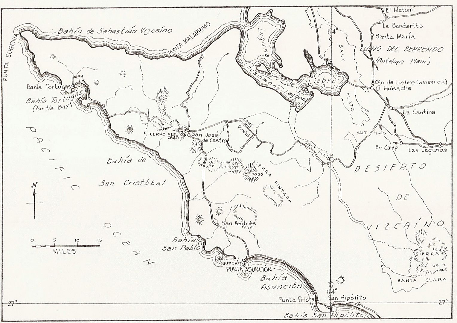
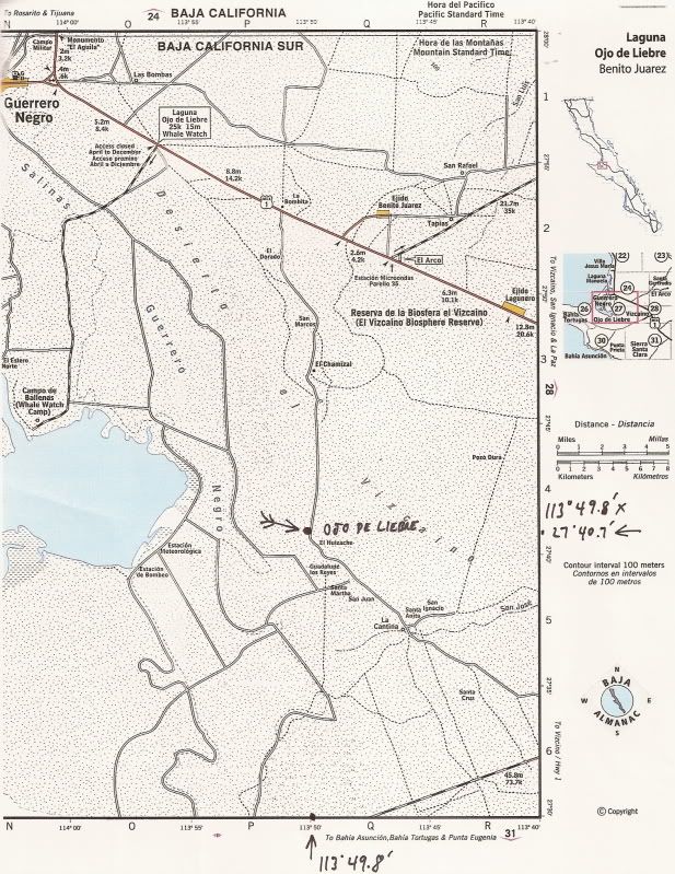
Use Google Earth... Here is a cut across via Ojo de Liebre spring and Rancho El Huizache. There are many parallel routes perhaps dating back to the 1950s when Pemex was exploring for oil in this desert...

The route I traced here leaves Highway One 4.0 miles beyond the paved Whale Watch turnoff... At Mile 10 take the right fork... At Mile 15.9 arrive Ojo de Liebre spring (take photos please)... At Mile 16.4 arrive Rancho El Huizache (may be abandoned, it is on the almanac)... At Mile 16.7 road heads east for 1.1 miles to... Mile 17.8 crossroad, turn south... At Mile 30.1 reach Vizcaino-Tortugas Highway.

Ojo de Liebre Bypass.jpg - 92kB

Obviously, use your own choice of roads and best judgement. What is seen from space a few years ago may no longer be driveable. Have fun... use a Spot or DeLorme InReach device and keep us alerted.

[Edited on 1-26-2016 by David K]

Udo - 1-26-2016 at 10:26 AM

Better judgement and wisdom should prevail. You'll spend more time getting out of the short cut than you would by driving to Vizcaino and to Bahia Tortugas.

rts551 - 1-26-2016 at 10:38 AM

Geoff,

I would not rely on old news what so ever in this area. There have been a lot of rains the last couple of years that would have changed everything and I would hate to hear of you stuck out in the middle of the salt flats. Check with a local who might know something about the area.

StuckSucks - 1-26-2016 at 11:04 AM

Quote: Originally posted by Udo  
Better judgement and wisdom should prevail. You'll spend more time getting out of the short cut than you would by driving to Vizcaino and to Bahia Tortugas.


That's immediately what I thought: Highway 1 down to Vizcaino is very fast (at least the way I drive) - I'd bet when the dust settles, Vizcaino is the faster way to go. That said, the shortcut sounds fun - it would be cool to see the Ojo de Liebre spring.

motoged - 1-26-2016 at 12:49 PM

Adventure entails a certain degree of risk.....stay east of the wet stuff:light:

4x4abc - 1-26-2016 at 01:39 PM

David,

that road going through Ojo de Liebre has what importance?
It's not the Old Baja Road
it's connecting what with what?

motoged - 1-26-2016 at 01:44 PM

There are a series of interconnecting roads....easy to get lost for some....a fun drive....real flat desert....not much vegetation....some cows....no gate at south end.....ranch gate not locked at north end...

[Edited on 1-26-2016 by motoged]

Desertbull - 1-26-2016 at 01:59 PM

Quote: Originally posted by motoged  
There are a series of interconnecting roads....easy to get lost for some....a fun drive....real flat desert....not much vegetation....some cows....no gate at south end.....ranch gate not locked at north end...

[Edited on 1-26-2016 by motoged]


Exactly what MotoGed says and lots of fun easy roads to navigate out there we just did it last week and had a blast...

David K - 1-26-2016 at 02:43 PM

Quote: Originally posted by 4x4abc  
David,

that road going through Ojo de Liebre has what importance?
It's not the Old Baja Road
it's connecting what with what?


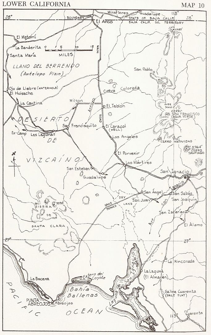
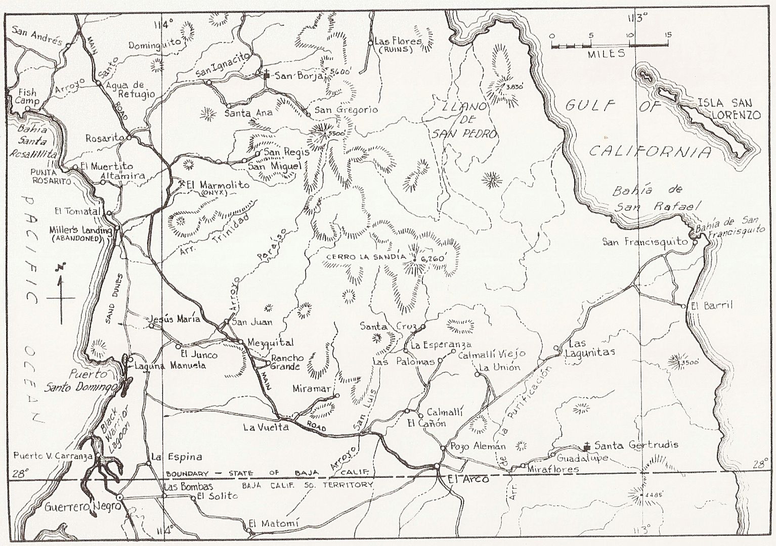
While the main Baja road went through El Arco, north of San Ignacio, after Guerrero Negro was created around 1957, truck traffic between it and San Ignacio would take the shorter route.

Here is the 1962 Gulick Map showing the roads in the Vizcaíno at that time:


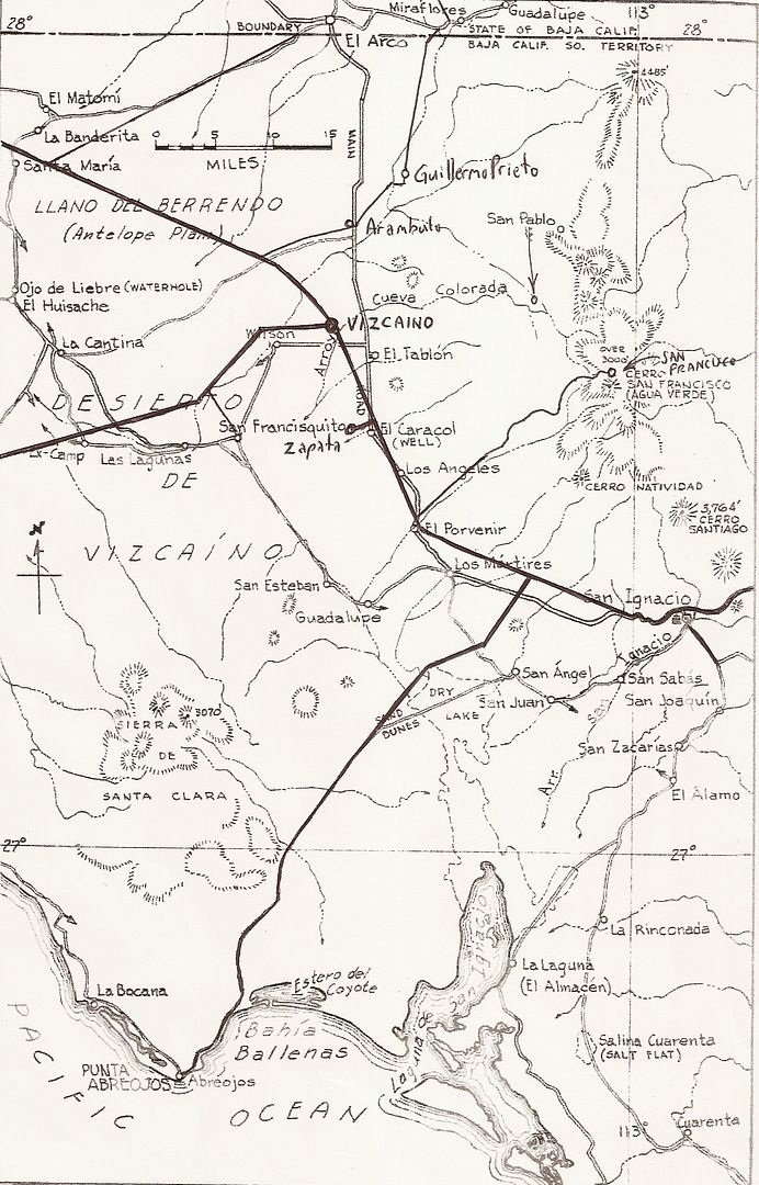
Mike Humfreville wrote about traveling with a supply trucker across the Vizcaíno in 1967. They took the road seen in the map via San Esteban. They would have passed Ojo de Liebre or a parallel road very near it.

Here is the second map above, with modern roads drawn in:


4x4abc - 1-26-2016 at 07:34 PM

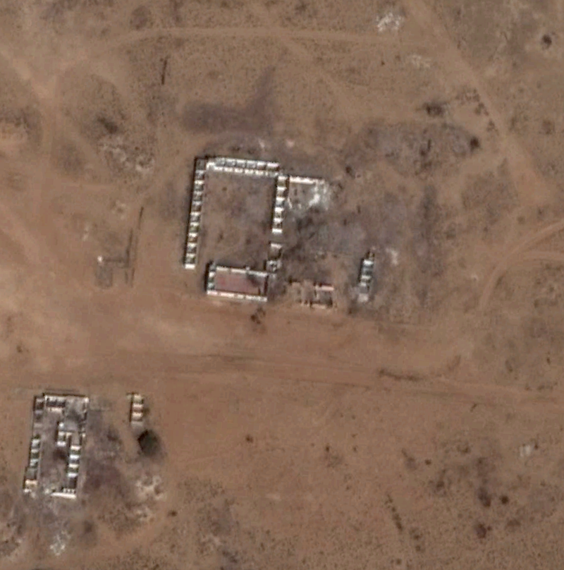
what was Las Bombas (just east of Guerrero Negro)?
wild network of roads

there a ruins that look like an old mission
but they look recent (hotel?)

rts551 - 1-26-2016 at 07:52 PM

Harald. An old Mision of sorts. Las Bombas was a group of Cantinas with rooms by the hour.

4x4abc - 1-26-2016 at 08:16 PM

strong resemblance

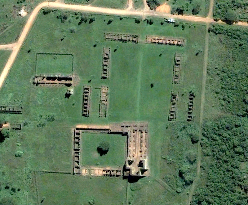
first Las Bombas - the place with a mission


and here a Jesuit mission of 1706 in Paraguay


what gives Las Bombas away as not a mission is the fact that all building angles are 90 degrees - no mission provides that

does anyone know why?

Udo - 1-26-2016 at 08:19 PM

Thanks for the cool old maps, DK!

They sure make light of the old dirt roads.

David K - 1-26-2016 at 10:44 PM

Quote: Originally posted by lencho  
Quote: Originally posted by David  

While the main Baja road went through El Arco, north of San Ignacio, after Guerrero Negro was created around 1957, truck traffic between it and San Ignacio would take the shorter route.

David, did you ever take that road through El Arco to San Ignacio before they put the highway in? I'm curious how developed El Arco was at that time.


Yes! That was the main "highway" to La Paz until 1973... I went that way in 1966, and it was just a small town based on mining gold kind of on both sides of an arroyo... but I was really young and we didn't do much more than buy gasolina (siphoned out of 55 gallon drums) there.

David K - 1-27-2016 at 07:56 AM

Quote: Originally posted by 4x4abc  
strong resemblance

first Las Bombas - the place with a mission

...

what gives Las Bombas away as not a mission is the fact that all building angles are 90 degrees - no mission provides that

does anyone know why?


In addition to Las Bombas, another cantina was just north in the pre-pavement days...

The history of the place name 'La Espinita' is a tad colorful...

Originally located a few miles north of Guerrero Negro...

(from 1962 Lower California Guidebook):

"La Espina (La Espinita), a solitary group of shacks serving as a saloon for salt works employees." :rolleyes:

Mike Humfreville had a good story about another brothel that served Guerrero Negro, a few miles east of town!


Here you go Harald, from a good friend of all us on Nomad, Mike Humfreville:

http://math.ucr.edu/ftm/bajaPages/Correspondents/MikeHumfrev...

W-h-o-r-e Town ( Posted February 12, 2003 )


Nothing very extraordinary happened during our week-long and accidental stay at Black Warrior in 1974. Our Land Cruiser, La Tortuga, was busted and in repair. Without a vehicle we had lots of time to kill, walking around town and sitting in small restaurants talking or reading over coffee. I had always kept a log and that filled my time. Mary Ann read romance novels. I was jealous.

One day, out of boredom, I decided it would be nice to have a bottle of red wine. I had no idea where to find one or even if there was a liquor store in the town. I left Mary Ann in our room, reading her book, and walked down the side streets to the main thoroughfare into and out of the town, a wide dirt road. In the center of town was a single, dust covered taxi. I asked the driver if he knew of a store that sold wine and liquor. He certainly did and immediately gestured for me to get into the cab. I told him I was fine to walk. He said it was too far to walk. He was animated and quick and insistent that I sit in his cab and be escorted to this store. Seeing no simple alternative, I climbed into the front passenger seat and we took off, east.

We passed through the salt company part of town and continued through the eastern part and we drove through the dump and straight out of town, under my constant questioning and his strong assurances that he knew exactly what I needed. We drove to the junction of the transpeninsular highway and, where the road forked for the northern and southern routes, we went straight, right up the middle.

We intersected the transpeninsular highway at 90 degrees and still we continued east into the desert. We drove several kilometers into an apparent nothingness. I would have been concerned, but my host was so carefree and casual. After a number of kilometers from the highway I could see a cluster of buildings in the distance. We entered the odd assemblage of fifteen or twenty one- and two-story structures spread across both sides of the road. There were men and women crossing the dusty street and coming from and going into the buildings. Many of the buildings had large signs advertising the availability of beer, music and dancing.

The driver stopped in front of one of these and jumped out and opened my door and with a bow and outstretched arm ushered me inside a dingy cantina. I'm thinking maybe they sell wines and liquors to go also. No such luck.

We entered a dark, large and windowless room with a bar and number of tables, a scattering of chairs. A number of men and two women stood at the bar, drinks scattered around. More men and women were sitting around the tables, some playing cards and dice. Rowdy recorded Mexican Mariachi music radiated from a dusty, battered record player in a corner of the room. Several couples were dancing. Many of the men were drunk. A sign on the wall told me that I could buy a dance for a peso, about a dime. I could judge from the scene that I could buy more than a dance for more than a peso. A scene out of the early American west, dark and dank, smoky, smelly, sleazy. I realized then that this actually was the early American west. It was just on another side of a border.

The place was a grimy dive and I was stuck with my friendly driver whose feelings I didn't want to hurt. But I had mixed emotions with the sorry sight of this roomful of dusty cowboys and oily overweight prostitutes. We went to the bar and I ordered two beers, one for my driver and one for me. I told him that my mediocre Spanish had perhaps conveyed the wrong message and that I really did just want a bottle of wine. I said that we should enjoy our beer and get back to town because people would be worried about me.

We watched the women, loudly mouthed and dressed, sidling with their men around the dance floor, their bodies close and suggestive and rocking with the music. I assumed that the second floors of the buildings were bedrooms. I was happy that this town existed for these people. But I had been ready to leave before we entered.

We finished our beers and I convinced a red-eyed semi-conscious fellow beside us that I really couldn't, at the moment, enjoy the services they had to offer, whatever they were and that I didn't know how to dance, thank you. We left, got back into the car and returned to Black Warrior, with my apologies to the driver.

I looked at our various maps of Baja occasionally over the many years since my experience with the friendly drunks and hoars and have not found this town identified. Until today. As I finished reviewing this before posting I opened my Baja Almanac and turned to N-29. There I spot it. It's just the right distance from Guerrero Negro, out in the forlorn desert. And it does have a name, after all. It's Las Bombas. The Pumps. How appropriate.


David K - 1-27-2016 at 08:01 AM

Shari posted this on 11-1-2010:

Now, I have a little story about La Bombas too. When I first lived in GN in 1988, there werent any bar a woman could go to. Women who dont carry cards (health certificates for prostitutes) werent allowed into the cantinas. So, in order to have a fun night out and go dancing...mis amigos took me to Las Bombas...which looked like a little settlement. There were several little bars and "houses"...kinda like little hotel rooms.

My first time there, I was amazed how cool it was...it was like a real bar...tables, juke box, dancefloor with a disco ball and lights and lots of smiling people dancing and drinking. Ladies were all dressed up...it was really fun. You bought little chips from the bar...different coloured ones was for different "activities". It was the most fun place in GN where you could really let your hair down...and we often took tourists there to show them a bit of local colour!!!

Things have come a long way since then...why I remember so many men staring at me as I drove through town in my pick up because no women drove then...it wasnt that long ago...or was it?


David K - 1-27-2016 at 09:07 AM

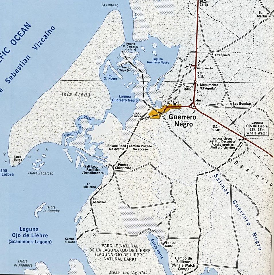
Here's the 1962 map showing both Las Bombas and La Espina


Close up, on the 2003 Baja Almanac:


4x4abc - 1-27-2016 at 09:10 AM

do we have a location for La Espinita?

4x4abc - 1-27-2016 at 10:26 AM

Quote: Originally posted by David K  
It's on the two maps just above... La Espina in 1962.


you are too fast - you posted the answer before I could post it

David K - 1-27-2016 at 10:57 AM

Harald, how about you post the satellite views of La Espina (Espinita)?

4x4abc - 1-27-2016 at 11:04 AM

Quote: Originally posted by David K  
Harald, how about you post the satellite views of La Espina (Espinita)?


too ugly

David K - 1-27-2016 at 07:06 PM

Quote: Originally posted by 4x4abc  
Quote: Originally posted by David K  
Harald, how about you post the satellite views of La Espina (Espinita)?


too ugly


In Baja California... there is the GOOD, the BAD, and the UGLY!

Enjoy...


geoffff - 1-28-2016 at 10:33 PM

Thanks everyone! I realize taking the paved road is faster, but exploring the dikes would be fun. The route I showed was generated with the help of Google Maps' "directions" route generation (they have all the dikes mapped as possible routes). I checked the whole route to make sure there were no gaps (water). Some of the older dikes seem to have these gaps.

Anyway I'd love to explore this route. But if there are explicit "no entry" signs, I would most likely not go in there.

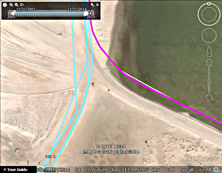
Using Google Earth, I do see evidence of some kind of signs at the north end of the dikes where the route (magenta line) leaves the north-south public-access road (cyan lines) to the whale campground here and starts going east: 27.761113 N 113.999016 W


I did try cutting the corner farther east on one of the dirt roads a few years ago, but I gave up a few miles in. It was slow, bumpy, and tedious. I'm up for slow & bumpy if it's interesting!

-- Geoff

David K - 1-28-2016 at 11:14 PM

I bet the signs say 'KEEP OUT!'?

I look forward to your discoveries... Your trip reports are always great!

Sorry for the extended sidebar on Las Bombas.. You just never know where a Baja Nomad thread will take you!

shari - 1-29-2016 at 04:57 PM

I guess you didnt understand where I said you need special permission and the salt works isnt giving out easily...especially not to foreigners as they have had problems with things getting stolen. It is also very confusing with all the roads and heavy equipment working. There are manned gates at the accesses.

David K - 1-29-2016 at 06:28 PM

Tourists are stealing salt mining equipment while on a vacation? Where do they put it in their campers?

I can imagine locals stealing for metal recycling maybe, but why are foreigners believed to be stealing from the salt operation... bizarro?

DianaT - 1-29-2016 at 08:32 PM

Quote: Originally posted by David K  
Tourists are stealing salt mining equipment while on a vacation? Where do they put it in their campers?

I can imagine locals stealing for metal recycling maybe, but why are foreigners believed to be stealing from the salt operation... bizarro?


They really don't want anyone messing around their operation --- tourist included.

We drove that back road from the Tortugas road into Guerrero Negro once because we were taking the Reserve Rep to the office to pick up his truck. He had the permission to pass and the gate keeper knows him.

As Shari said, not just anyone can get that permission; I do know that the local BA Bike team permission once, but they are locals. We were glad to have the Rep with us as he knew the correct roads to take and as it was after a rain, some of the roads were not passable. Besides, we would have never been able to get permission to pass the gate.

It is really ugly back there, but we were glad we had the opportunity to see it the one time.

David K - 1-29-2016 at 09:18 PM

Nice!

I can understand this is a mine and not a public road. It was just Shari saying it is closed party due to foreigners stealing stuff from the mine property I couldn't visualize.

Any photos since it is a forbidden area most won't be able to see?

geoffff - 1-31-2016 at 12:20 AM

Quote: Originally posted by shari  
I guess you didnt understand where I said you need special permission and the salt works isnt giving out easily...especially not to foreigners as they have had problems with things getting stolen. It is also very confusing with all the roads and heavy equipment working. There are manned gates at the accesses.


Thanks, shari & DianaT. I guess I was holding out hope that this might only apply to the area just southwest of Guerrero Negro, which is marked as no access on my Baja Almanac, and not the areas southeast and farther south. But I am convinced now and will let it be :)

I was tempted because Google Earth shows some Panaramio photos of users who have gone this route I was considering, and taken some geotagged photos in there. But I guess these people got permission to go in, or work there etc.

Google Earth is how I plan my Baja exploration ideas these days -- looking for those geotagged photos it shows in interesting places.

-- Geoff

geoffff - 1-31-2016 at 12:24 AM

Quote: Originally posted by David K  
I look forward to your discoveries... Your trip reports are always great!


Thanks, David! I've got a Baja trip coming up next month. Looking for ideas. I'm definitely planning on getting into some more trouble.

-- Geoff

shari - 1-31-2016 at 07:53 AM

David....I NEVER said foreigners were stealing stuff...highly unlikely as very few are in there...but more likely local folks were responsible...deisel fuel, parts, equipment etc. have been stolen. They put a new gate at area 9 where we used to go bird watching too...this is the road that curves left just before you get to the lagoon gate.

The road to the lagoon does go through the salt works so you can see the terrain and operation there. FYI, the salt works gives free tours at 10 & 2 if you go to their office and ask for one...the guide rides in your car..very interesting and you see the whole operation....or take a tour from a tour operator like Malarrimo, Caracol Hotel, Cowboy Hotel, Marios tours or from Eddie at Las Cazuelas restaurant.

David K - 1-31-2016 at 10:26 AM

Thank you for clarifying Shari!
It was this line you posted about geoffff using the company roads that made it sound so "....especially not to foreigners as they have had problems with things getting stolen."

The tour idea sound great! So we just need to have room for one passenger? Is there a cost or do we give him a tip, buy him lunch?