| Pages:
1
2 |
geoffff
Senior Nomad
  
Posts: 710
Registered: 1-15-2009
Member Is Offline
|
|
Vizcaino shortcut idea?
I know it wouldn't actually save me any time, but does anyone know if the public is allowed to drive through salt areas south of Guerrero Negro? I'm
looking for a "shortcut" to the Bahia Tortugas road -- to bypass having to drive all the way to the Vizcaino intersection on Hwy 1, and then go back
east. My idea is to drive south to the whale campground on Estero Norte, and then try continuing south like this:
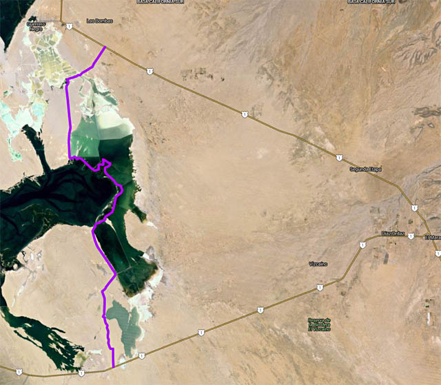
(Google Maps link)
The Baja Almanac says the salt areas just southwest of Guerrero Negro town are private/no access, but doesn't say anything about the "salinos"
southeast of town and east of Laguna Ojo de Liebre.
-- Geoff
|
|
|
David K
Honored Nomad
        
Posts: 65410
Registered: 8-30-2002
Location: San Diego County
Member Is Offline
Mood: Have Baja Fever
|
|
In the past (before paved roads), one would go to the salt company office and request permission to cross over/ short cut to get out to Malarrimo
Beach or Bahia Tortugas.
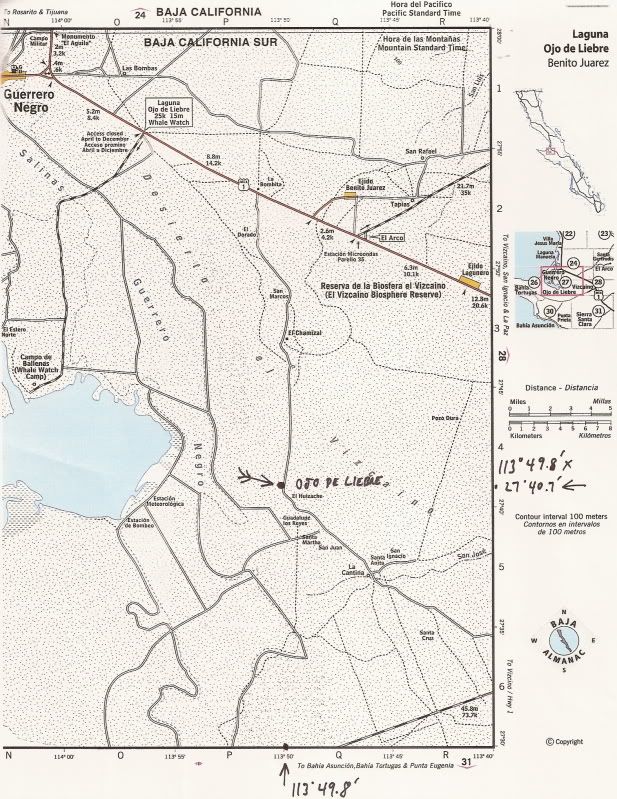
Edit: Just a little longer, but go around via the historic water hole 'Ojo de Liebre' that the Mexicans renamed Scammon's Lagoon after. That spring
was the only source of water for many many miles back in the day!
I did a thread on it with photos and maps... and a Nomad found it and added photos.
http://forums.bajanomad.com/viewthread.php?tid=43742
[Edited on 1-26-2016 by David K]
|
|
|
motoged
Elite Nomad
     
Posts: 6481
Registered: 7-31-2006
Location: Kamloops, BC
Member Is Offline
Mood: Gettin' Better
|
|
Geoffffffffffffff,
I have ridden a motorcycle (dirtbike) on a north-south route that didn't go through the water (like it looks like your route would)...this was east
of your route and was a good sand hardpack road for the majority of the way....
I started at the Asuncion-Vizcaino highway where there appears to be a pumping station and a large radio type tower (20-30 kms west of
Vizcaino)....and rode north....came out about 10 miles or so south of Guerrero Negro (south of road from Hwy 1 to whale watching area)
Don't believe everything you think....
|
|
|
shari
Select Nomad
      
Posts: 13052
Registered: 3-10-2006
Location: bahia asuncion, baja sur
Member Is Offline
Mood: there is no reality except the one contained within us "Herman Hesse"
|
|
You do need a special authorization from the ESSA salt works and they arent likely to give it to a tourist. It is a maze of roads and people get lost
and they have had some thefts of equipment so arent giving permits readily. Plus it is all salt on the roads and if there is any rain at all, they
turn to a salt slurry...so no short cut for you!
|
|
|
ncampion
Super Nomad
   
Posts: 1238
Registered: 4-15-2006
Location: Loreto
Member Is Offline
Mood: Retired and Loving it
|
|
I remember doing that route (approximately) on a dirt bike, but it was about 20 years ago. At that time, no permission needed, but as Shari said it
is a maze of roads and we did get lost but luckily came across a worker in a truck that pointed us in the right direction. Surrealistic scenery as I
recall.
Living Large in Loreto. Off-grid and happy.
|
|
|
Bajaboy
Ultra Nomad
    
Posts: 4375
Registered: 10-9-2003
Location: Bahia Asuncion, BCS, Mexico
Member Is Offline
|
|
Quote: Originally posted by motoged  | Geoffffffffffffff,
I have ridden a motorcycle (dirtbike) on a north-south route that didn't go through the water (like it looks like your route would)...this was east
of your route and was a good sand hardpack road for the majority of the way....
I started at the Asuncion-Vizcaino highway where there appears to be a pumping station and a large radio type tower (20-30 kms west of
Vizcaino)....and rode north....came out about 10 miles or so south of Guerrero Negro (south of road from Hwy 1 to whale watching area)
|
I've done something similar. I think there might be a few roads that cut across.
|
|
|
David K
Honored Nomad
        
Posts: 65410
Registered: 8-30-2002
Location: San Diego County
Member Is Offline
Mood: Have Baja Fever
|
|
Use Google Earth... Here is a cut across via Ojo de Liebre spring and Rancho El Huizache. There are many parallel routes perhaps dating back to the
1950s when Pemex was exploring for oil in this desert...
The route I traced here leaves Highway One 4.0 miles beyond the paved Whale Watch turnoff... At Mile 10 take the right fork... At Mile 15.9 arrive Ojo
de Liebre spring (take photos please)... At Mile 16.4 arrive Rancho El Huizache (may be abandoned, it is on the almanac)... At Mile 16.7 road heads
east for 1.1 miles to... Mile 17.8 crossroad, turn south... At Mile 30.1 reach Vizcaino-Tortugas Highway.

Obviously, use your own choice of roads and best judgement. What is seen from space a few years ago may no longer be driveable. Have fun... use a Spot
or DeLorme InReach device and keep us alerted.
[Edited on 1-26-2016 by David K]
|
|
|
Udo
Elite Nomad
     
Posts: 6364
Registered: 4-26-2008
Location: Black Hills, SD/Ensenada/San Felipe
Member Is Offline
Mood: TEQUILA!
|
|
Better judgement and wisdom should prevail. You'll spend more time getting out of the short cut than you would by driving to Vizcaino and to Bahia
Tortugas.
Udo
Youth is wasted on the young!
|
|
|
rts551
Elite Nomad
     
Posts: 6700
Registered: 9-5-2003
Member Is Offline
|
|
Geoff,
I would not rely on old news what so ever in this area. There have been a lot of rains the last couple of years that would have changed everything
and I would hate to hear of you stuck out in the middle of the salt flats. Check with a local who might know something about the area.
|
|
|
StuckSucks
Super Nomad
   
Posts: 2368
Registered: 10-17-2013
Location: Pacific Plate
Member Is Offline
|
|
Quote: Originally posted by Udo  | | Better judgement and wisdom should prevail. You'll spend more time getting out of the short cut than you would by driving to Vizcaino and to Bahia
Tortugas. |
That's immediately what I thought: Highway 1 down to Vizcaino is very fast (at least the way I drive) - I'd bet when the dust settles, Vizcaino is the
faster way to go. That said, the shortcut sounds fun - it would be cool to see the Ojo de Liebre spring.
|
|
|
motoged
Elite Nomad
     
Posts: 6481
Registered: 7-31-2006
Location: Kamloops, BC
Member Is Offline
Mood: Gettin' Better
|
|
Adventure entails a certain degree of risk.....stay east of the wet stuff
Don't believe everything you think....
|
|
|
4x4abc
Ultra Nomad
    
Posts: 4454
Registered: 4-24-2009
Location: La Paz, BCS
Member Is Offline
Mood: happy - always
|
|
David,
that road going through Ojo de Liebre has what importance?
It's not the Old Baja Road
it's connecting what with what?
Harald Pietschmann
|
|
|
motoged
Elite Nomad
     
Posts: 6481
Registered: 7-31-2006
Location: Kamloops, BC
Member Is Offline
Mood: Gettin' Better
|
|
There are a series of interconnecting roads....easy to get lost for some....a fun drive....real flat desert....not much vegetation....some cows....no
gate at south end.....ranch gate not locked at north end...
[Edited on 1-26-2016 by motoged]
Don't believe everything you think....
|
|
|
Desertbull
Senior Nomad
  
Posts: 558
Registered: 8-27-2003
Member Is Offline
|
|
Quote: Originally posted by motoged  | There are a series of interconnecting roads....easy to get lost for some....a fun drive....real flat desert....not much vegetation....some cows....no
gate at south end.....ranch gate not locked at north end...
[Edited on 1-26-2016 by motoged] |
Exactly what MotoGed says and lots of fun easy roads to navigate out there we just did it last week and had a blast...
DREAM IT! PLAN IT! LIVE IT!
|
|
|
David K
Honored Nomad
        
Posts: 65410
Registered: 8-30-2002
Location: San Diego County
Member Is Offline
Mood: Have Baja Fever
|
|
Quote: Originally posted by 4x4abc  | David,
that road going through Ojo de Liebre has what importance?
It's not the Old Baja Road
it's connecting what with what? |
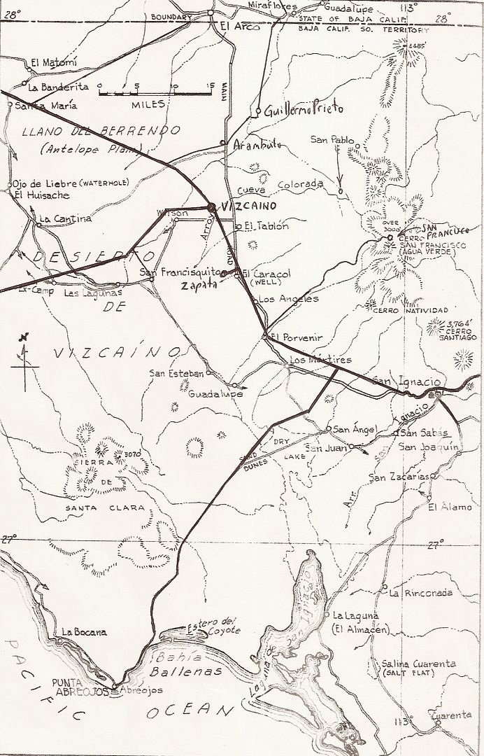
While the main Baja road went through El Arco, north of San Ignacio, after Guerrero Negro was created around 1957, truck traffic between it and San
Ignacio would take the shorter route.
Here is the 1962 Gulick Map showing the roads in the Vizcaíno at that time:
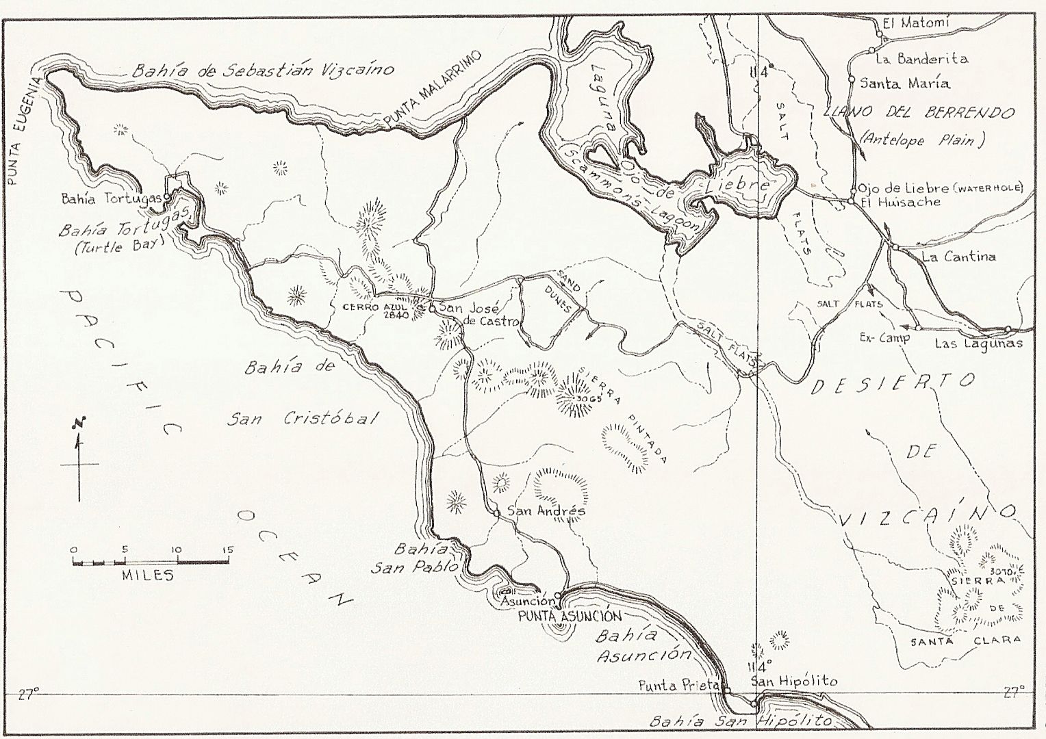
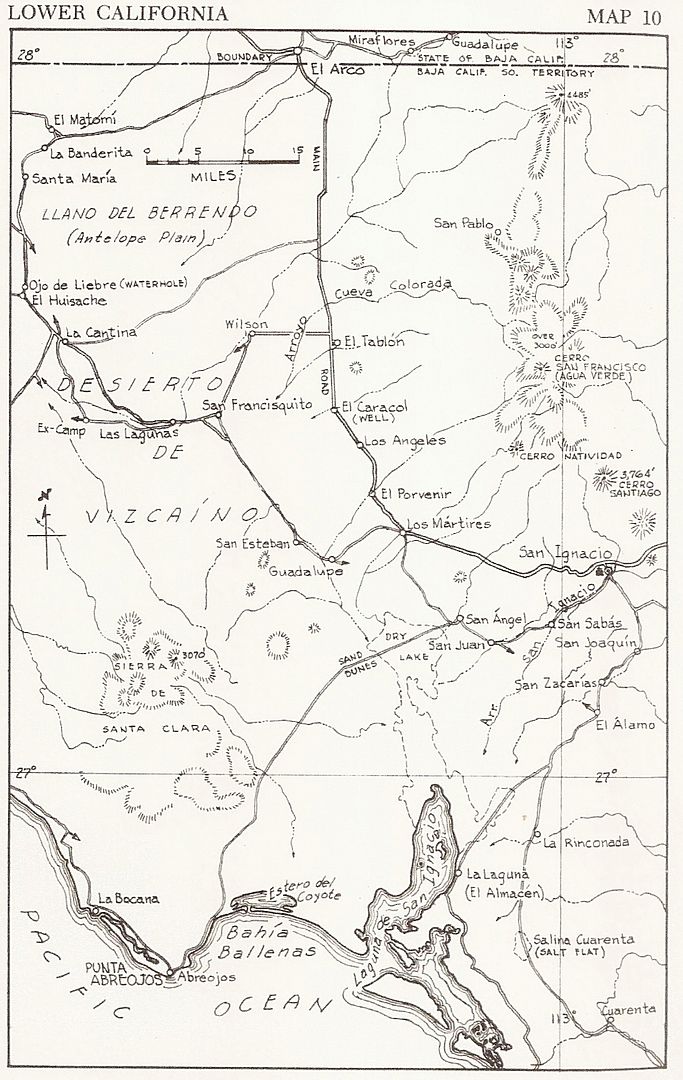
Mike Humfreville wrote about traveling with a supply trucker across the Vizcaíno in 1967. They took the road seen in the map via San Esteban. They
would have passed Ojo de Liebre or a parallel road very near it.
Here is the second map above, with modern roads drawn in:
|
|
|
4x4abc
Ultra Nomad
    
Posts: 4454
Registered: 4-24-2009
Location: La Paz, BCS
Member Is Offline
Mood: happy - always
|
|
what was Las Bombas (just east of Guerrero Negro)?
wild network of roads
there a ruins that look like an old mission
but they look recent (hotel?)
Harald Pietschmann
|
|
|
rts551
Elite Nomad
     
Posts: 6700
Registered: 9-5-2003
Member Is Offline
|
|
Harald. An old Mision of sorts. Las Bombas was a group of Cantinas with rooms by the hour.
|
|
|
4x4abc
Ultra Nomad
    
Posts: 4454
Registered: 4-24-2009
Location: La Paz, BCS
Member Is Offline
Mood: happy - always
|
|
strong resemblance
first Las Bombas - the place with a mission
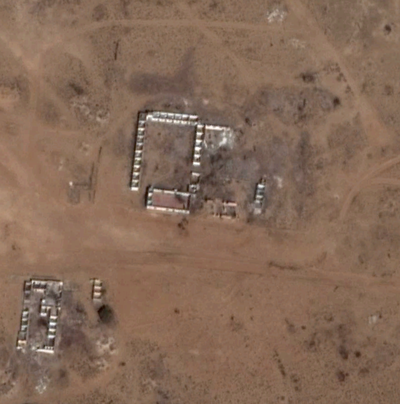
and here a Jesuit mission of 1706 in Paraguay
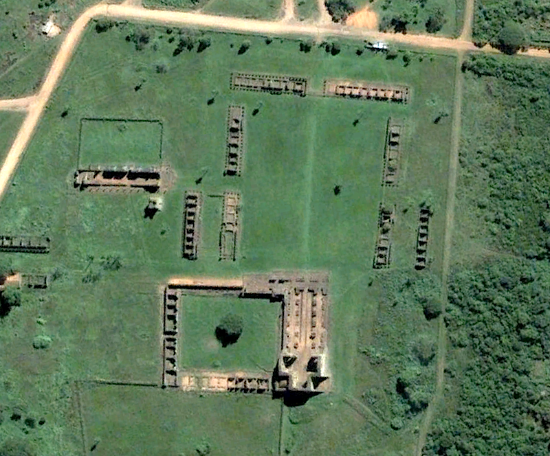
what gives Las Bombas away as not a mission is the fact that all building angles are 90 degrees - no mission provides that
does anyone know why?
Harald Pietschmann
|
|
|
Udo
Elite Nomad
     
Posts: 6364
Registered: 4-26-2008
Location: Black Hills, SD/Ensenada/San Felipe
Member Is Offline
Mood: TEQUILA!
|
|
Thanks for the cool old maps, DK!
They sure make light of the old dirt roads.
Udo
Youth is wasted on the young!
|
|
|
David K
Honored Nomad
        
Posts: 65410
Registered: 8-30-2002
Location: San Diego County
Member Is Offline
Mood: Have Baja Fever
|
|
Quote: Originally posted by lencho  | Quote: Originally posted by David  |
While the main Baja road went through El Arco, north of San Ignacio, after Guerrero Negro was created around 1957, truck traffic between it and San
Ignacio would take the shorter route. |
David, did you ever take that road through El Arco to San Ignacio before they put the highway in? I'm curious how developed El Arco was at that time.
|
Yes! That was the main "highway" to La Paz until 1973... I went that way in 1966, and it was just a small town based on mining gold kind of on both
sides of an arroyo... but I was really young and we didn't do much more than buy gasolina (siphoned out of 55 gallon drums) there.
|
|
|
| Pages:
1
2 |

