BajaNomad

Wreck between Erendira and Pta Cabras

DosMars - 2-1-2016 at 08:19 AM

I've heard of a ship going aground along this stretch but don't know exactly where. Can anyone point out on the almanac or put up a Google-earth snapshot of where this wreck is located? From what I understand there isn't much of anything left of it but I would be interested in jumping in the water to see if there are any brass fittings scattered about...

[Edited on 2-1-2016 by DosMars]

chippy - 2-1-2016 at 09:27 AM

Which century? There is a shipwreck south of 4 casas. Its been there for decades.

DosMars - 2-1-2016 at 09:32 AM

This century, maybe sixties or seventies? Where exactly is 4 casas?

[Edited on 2-1-2016 by DosMars]

David K - 2-1-2016 at 09:45 AM


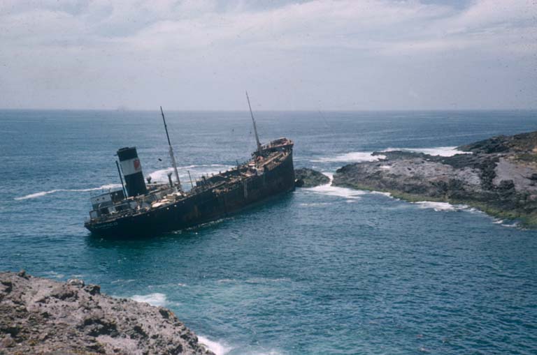
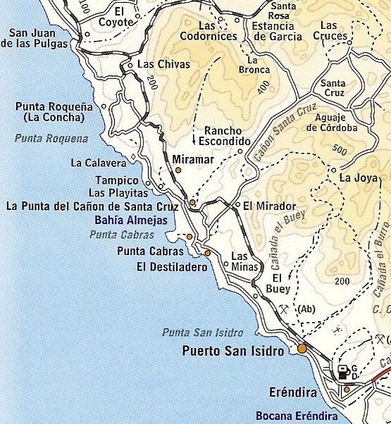
This is the Tampico that went aground near Punta Cabras in or around 1957. Photo by Howard Gulick, of the Lower California Guidebook.

See "Tampico" on the map?


[Edited on 2-1-2016 by David K]

BigBearRider - 2-1-2016 at 09:46 AM

I think you are thinking of Punta San Jacinto. Look it up.

David K - 2-1-2016 at 10:00 AM

Quote: Originally posted by DosMars  
This century, maybe sixties or seventies? Where exactly is 4 casas?

[Edited on 2-1-2016 by DosMars]


Cuatro Casas is on the coast between Colonet and Camalu by Punta San Telmo. Access near the Observatory road junction.

The shipwreck south of there is closer to Punta San Jacinto...
Here are some photos I took in June, 2014:


BigBearRider - 2-1-2016 at 11:00 AM

The more you know! I didn't know about the Tampico wreck.

The helicopter looks like the one from the Rip to Cabo and Trail of Missions shows.

DosMars - 2-1-2016 at 11:03 AM

Looks like the Tampico is the one I'm thinking about. For some reason I thought it was south of Pta Cabras...
Thanks for the info, am I right in assuming theres isn't much left visible from shore? I'll plan on doing a little spearfishing around that area next time I'm camped out at Pta Cabras. May find something interesting among the rocks.

DosMars - 2-1-2016 at 11:13 AM

Looking at google earth, there are a few coves along that stretch that look like they could be the one in the photo. Is there a landmark nearby that let's you know you're at the right spot?

David K - 2-1-2016 at 11:59 AM

Quote: Originally posted by BigBearRider  
The more you know! I didn't know about the Tampico wreck.

The helicopter looks like the one from the Rip to Cabo and Trail of Missions shows.


2014 Trail of Missions, yes... I rode in that copter from El Cajon to San Vicente to then hop into Cameron's Raptor for the rest of Day One. I returned in the copter from near Mission San Fernando back to El Cajon.

There's no experience quite like flying low over Baja! Riding with Cameron Steele and others was no small event, either!

I posted a ton of photos from the copter and the ground of that ride... It was in June 2014: http://forums.bajanomad.com/viewthread.php?tid=74324

BajaGeoff - 2-1-2016 at 04:19 PM

Dos Mars....there is a very obvious sign that says Rancho Tampico as you are passing by the cove and ranch house. No part of the wreck is visible from land anymore and not sure what lies beneath! Curious to know what you come across!

Google Earth coordinates are:
31°21'2.64"N
116°27'52.59"W

DosMars - 2-1-2016 at 05:06 PM

Thank you Geoff, those coordinates took me right to the cove on GE. That and the heads up on the ranch sign should get me to the right spot.
Always looking for an excuse to head south of the boarder, treasure hunting for brass fittings is a great excuse to jump in the water!

-Mark...

Here's one that may still have lots of brass

durrelllrobert - 2-1-2016 at 05:43 PM

Quote: Originally posted by DosMars  
I've heard of a ship going aground along this stretch but don't know exactly where. Can anyone point out on the almanac or put up a Google-earth snapshot of where this wreck is located? From what I understand there isn't much of anything left of it but I would be interested in jumping in the water to see if there are any brass fittings scattered about...

[Edited on 2-1-2016 by DosMars]


Thrashing El Nino storms this week, which stripped a great deal of sand from the shores of Coronado, California, have revealed an amazing glimpse into history.

Phot : http://media.nbcbayarea.com/designimages/transparent.gif
During low tide Saturday, the rusted remains of the (300 foot) SS Monte Carlo emerged from the beach, close to Avenida de las Arenas. Joe Ditler, who has been studying the shipwreck for 30 years, was there to snap pictures of the wreckage, which appears from time to time when sand is sparse.

According to Ditler, a vicious storm rocked the Monte Carlo on Dec. 31, 1936, breaking the ship from its moorings three miles from Coronado’s shore. In the Prohibition days, the ship was anchored in international waters to avoid U.S. laws. People searching for gambling, prostitution or bootleg whiskey would take smaller boats out to the “sin ship” for a night of revelry, Ditler told NBC 7. Famous actors such as Clark Gable and Mae West reportedly gave the Monte Carlo their patronage.

He said there were rumors that at least $100,000 worth of silver dollars was buried with the wreckage when sand washed over the Monte Carlo.

http://media.nbcbayarea.com/designimages/transparent.gif

Source: http://www.nbcsandiego.com/news/local/El-Nino-Storms-Unearth...
Follow us: @nbcsandiego on Twitter | NBCSanDiego on Facebook

[Edited on 2-2-2016 by durrelllrobert]

DosMars - 2-1-2016 at 06:27 PM

Cool! May have to take a drive down to check that one out. He says in the article that in all the time he's been studying the Monte Carlo this is the most the wreck has been exposed. Lot's of metal detectors going over that beach this weekend looking for some of the missing silver I'd imagine...

Barry A. - 2-2-2016 at 09:50 AM

As a teenager in Coronado, CA back in the late '40's, early '50's the Monte Carlo was at times mostly exposed above the sands and we often poked around it and into the cargo holds a little way. Those periods were always brief, and the wreck was soon mostly covered up again, but always a little was exposed so you knew where it was. As I recall, it was the winter storms that exposed it.

David K - 2-2-2016 at 09:54 AM

Quote: Originally posted by Barry A.  
As a teenager in Coronado, CA back in the late '40's, early '50's the Monte Carlo was at times mostly exposed above the sands and we often poked around it and into the cargo holds a little way. Those periods were always brief, and the wreck was soon mostly covered up again, but always a little was exposed so you knew where it was. As I recall, it was the winter storms that exposed it.


Very cool Barry! Thank you for sharing your story.

pappy - 2-4-2016 at 12:20 PM

Can,t believe how deteriorated the ship at jack to has become. Last time I was there was about twenty years ago