Has anyone driven the Las Pocitas/San Evaristo road through Los Bosques this spring? Haven't been down that coast in some years and are planning on
doing the loop from Centenario to La Pocitas along the coast. Not sure if we'll be doing it north to south or south to north. Driving a 4-wheel
drive Nissan V6 so should have no trouble if the road is at all passable.
Thanks.AKgringo - 5-7-2016 at 08:42 AM
I suggest traveling up to San Evaristo along the coast first, then over the pass. That way, if the road is not passable, at least you got to visit
some of the best of it!
Edit, This guy got around (jealousy showing here)! The San Evaristo potion is toward the bottom of this epic report.
[Edited on 5-7-2016 by AKgringo]Paulclark - 5-7-2016 at 09:04 AM
Could be a little rough as they just ran the Dos Mares race over it and the race cars tend to kick up rocks. David K - 5-7-2016 at 09:15 AM
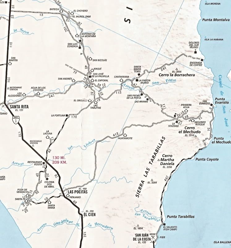
Just for a visual on the area of discussion:
Note that THREE mission sites are on the above map.
1) Dolores del Sur 1721-1741 (first location of Dolores del Sur)
2) La Pasión (the final location for Dolores del Sur) 1741-1768
3) San Luis Gonzaga 1737-1768
History is all over Baja!
The El Camino Real mission road is also crossed many times when driving this region.
[Edited on 5-7-2016 by David K]Udo - 5-7-2016 at 09:25 AM
That trip was a real nice post!
Look forward to myself taking the same trip.Bob and jane - 5-7-2016 at 09:40 AM
Thanks for the info. Love the picture report, AKgringo. Can't wait to get back there. We recognized all his photos along the way. I know there are
lots and lots of race fans out there but the mess they make of the roads does make things difficult for the rest of us...............
I should add, that when I made that loop from Centanario, just about two years ago, I missed the turn that leads to Las Pocitas. I wound up taking a
longer route that would be the center road to Hwy 1 (DK's map insert).
No regrets, it was a great drive, and now I get to look forward to doing the southern leg that I missed!
LaTijereta - 5-8-2016 at 08:00 AM
The road is in good shape.. ran over it about a month ago.. coming up from La Paz... It was part of the Dos Mares course which ran through it last
week..
The turn-off to Los Pocitas to the hwy is at Las Golondrinas.. about 18 miles off the hwy in.. Bob and jane - 5-13-2016 at 01:35 PM
We returned from our Evaristo trip yesterday (Thursday). We drove north from Centenario. The first part of the dirt road to Portuguese was better
than expected. We've seen some monster washboards on that road in the past. The hills were in rough shape, quite chewed up. We were glad we weren't
driving our Dodge Ram with the pop-up camper on the back. Even though it is not that top-heavy, we would have had some serious rocking issues going
on.
We actually drove this road in '92, '93, '94 and '95 driving a Suburban pulling a tent trailer and hauling two young boys, a dog, an inflatable boat
and motor, and coolers full of ice and food. Everytime I have driven the road since, I have marveled at our................ .determination? I was
scared every time we went over those hills. Back then the road was even narrower, no way to dodge boulders growing out of the road bed. We would
stop before the steep sections and get out to listen for any traffic coming our way. Fortunately we never saw anyone else when we were on the road.
Back to the road report. We resorted to 4 wheel drive frequently but had no serious trouble getting over the hills. We camped at what we call
"frigate hill," for several nights. In Evaristo, before we headed back home, we were told NOT to go back through Los Bosques to Las Pocitas. We
asked a number of different people just to be sure everyone agreed. Every person said that two races had gone up that hill and out and that it was in
terrible condition. They themselves would not use that road. And, they said, it wasn't just the first 5 or 6 miles going up the hill, but it was bad
all the way to the highway. So we came back the way we had gone. Beautiful drive anyway. Took us 45 minutes to go from camp over the hills to
Portuguese, about 8.5 miles. The next 40 miles to San Juan de la Costa took an hour and 15 minutes.
That is the road report as of May 12. It's getting too hot to camp out much down there now anyway. I'm sure it will change again before next season.
Footnote: In Evaristo they were unloading crate after crate of cochitos from the fishing boats. We were told they had over a ton of cochitos from
San Jose Island. I can't imagine a ton of cochi. I can't imagine that will happen too often...............dtbushpilot - 5-13-2016 at 03:52 PM
Thanks for the trip update Bob and Jane. What is a cochito?Bob and jane - 5-13-2016 at 04:26 PM
Diminutive of cochi. Also known as trigger fish.David K - 5-13-2016 at 06:37 PM
Portuguese?Fernweh - 5-13-2016 at 06:46 PM
I was just out today below San Juan de la Costa , and cruised the water there, looking for Cochitos.
Caught a few, but saw other fisherman with a type lobster trap, catching those Coshis. Ever time they pulled up a trap, they had fish in there.
No wonder.....a ton of fish!Bob and jane - 5-13-2016 at 07:07 PM
David K, Portuguese is a fishing camp at the bottom (south end) of the first small-ish hill heading up and around Punta Mechudo. Was a seldom used
temporary camp in the early 90's but is a fairly permanent small fish camp today. I believe it is called that on the Baja atlas and some other maps.
Today there is a sign on the road identifying it.
Fernweh: Such a bummer................What will be left?AKgringo - 5-13-2016 at 07:09 PM
There is a sign indicating 'Portugese camp' along that road. I don't remember if it was just north or south of Punta coyote on the map you attached.
Edit; It looks like I typed too slow! I think that it is about the last place you could beach launch without pulling a trailer up and around some
switchbacks and bumpy road.
[Edited on 5-14-2016 by AKgringo]4x4abc - 5-13-2016 at 07:32 PM
where is Portuguese? Never heard of itdtbushpilot - 5-13-2016 at 08:57 PM
On a slow troll from Buena Vista to Bahia de los Muertos a couple of days ago I came across several large schools of small triggers, haven't seen them
like that before. Not sure if I've not noticed them before or if there is more of them here now. David K - 5-13-2016 at 10:48 PM
I looked at the Almanac before asking, didn't see it. Sounds like it is near Punta Coyote and or Punta Mechudo from the replies so far?4x4abc - 5-13-2016 at 11:12 PM
found it - mountain top: 24°46'14.37"N, 110°41'36.46"W
so, maybe they meant the rocky beach at the bottom of Cañada El Fraile (it's close by)David K - 5-14-2016 at 06:33 AM
found it - mountain top: 24°46'14.37"N, 110°41'36.46"W
so, maybe they meant the rocky beach at the bottom of Cañada El Fraile (it's close by)
Well Harald, since you are a bit closer than me, I hope to see photos soon!
not my kind of beach/camping spot - it is very rocky. But there are always some Gringos camped there. Glad, they don't like "my" beaches.
May have to do with the fact that i like fine, soft sand. Most don't know how to get there. So, it's the rocky beaches for them.Bob and jane - 5-14-2016 at 07:44 AM
AKgringo, you are correct on the location of Portuguese. It is north of Coyote at the bottom of the first steep hill with switchbacks clinging to the
edge of the sea. If you've driven the road, you know the hill well. It is easy going compared to the next two hills you have to cross.
Lots of sandy beaches here and there between San Juan de la Costa and Portuguese and there are several when you get north of Mechudo before Evaristo.
The only really rocky beach where people camp is just north of the first steep hill I mention above.4x4abc - 5-14-2016 at 10:29 AM
OK Campo Portuguese: 24°44'51.59"N, 110°40'51.63"W
a very beautiful spot
soft sandy beach south of it
Harald, like you I find pure sand the greatest place to camp be it a beach or an arroyo. AKgringo - 5-14-2016 at 02:55 PM
Much of that area is composed of layers or pastel green, red, and grey soft stone. I found one narrow beach, less than a half mile off the road, that
was pink sand at the base of a multicolored, layered bluff with a sea floor of green bed rock.
At low tide, it looked like something out of a Star Trek set! A neat camp spot, but no place to be in a storm!
I did quite a few day trips, and a couple of overnighters in that area while I was staying near La Paz. The arroyos leading to the sea, or away from
it provide some great sightsseeing.