BajaNomad

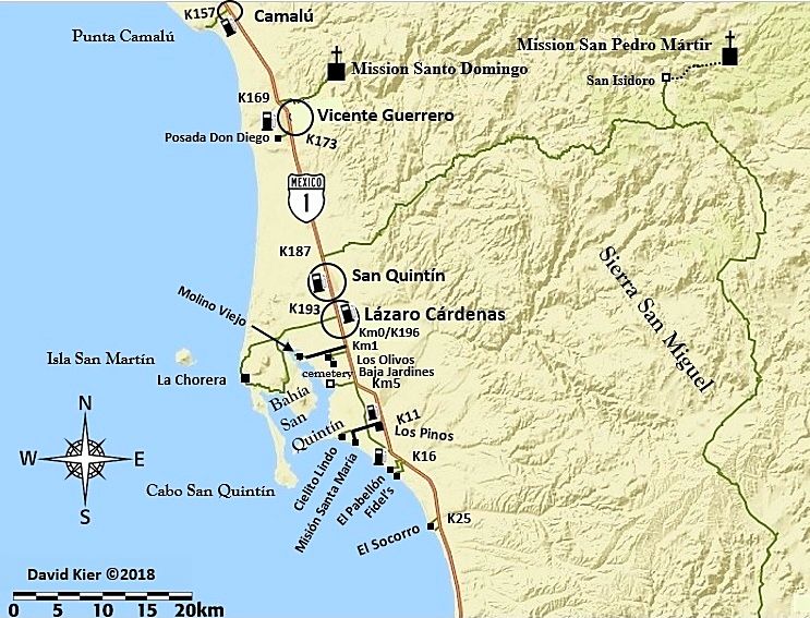
Newest 2018 Map: San Quintín Area

David K - 1-11-2018 at 03:47 PM

Please have a look and tell me if it flies for you.

I included the Sierra San Miguel mountain road, San Isidoro, etc. as TW and Squarecircle and other have been on it, and I would like to one day. I limited some of the data, like gas stations (there are plenty in this section). I almost left out the Km markers as I thought it may get too busy.


[Edited on 5-1-2018 by David K]

bajaguy - 1-11-2018 at 04:11 PM

Put Parcela 12 on the map....it's a must see/eat location!!

David K - 1-11-2018 at 04:13 PM

Quote: Originally posted by bajaguy  
Put Parcela 12 on the map....it's a must see/eat location!!


It is in the guide! ;)

Km. 16 El Pabellon (1.2 miles) Campground/RV Park (150 pesos). A popular restaurant, Parcela 12, is just ahead on the east side of the highway.

4x4abc - 1-11-2018 at 04:18 PM

no gas stations?

weebray - 1-11-2018 at 04:49 PM

Quote: Originally posted by 4x4abc  
no gas stations?


Not to worry, plenty in the area and putting them in would only confuse the issue. I prefer the clean look. Personal favorites can be noted on your own copy.

David K - 1-11-2018 at 05:29 PM

Gas stations added!

[Edited on 7-9-2018 by David K]

bajabuddha - 1-11-2018 at 05:31 PM

How about adding an 'inset' map of the greater San Quintin area only and have gas, hotels, etc. marked w/ turn-off km's? Kinda like City inset maps in road atlases? Por que no?

David K - 1-11-2018 at 05:40 PM

Quote: Originally posted by bajabuddha  
How about adding an 'inset' map of the greater San Quintin area only and have gas, hotels, etc. marked w/ turn-off km's? Kinda like City inset maps in road atlases? Por que no?


That would be great for a stand-alone map, yes.

These maps are mated to the Guide so that readers of the Guide can have a quick and easy visual depiction of where they are compared to other places noted in the Guide. I am showing these maps to all of you not for your enjoyment only, as they do go with the road logs I have made. But, to help me make sure they are easy to see/understand, don't have incorrect data, and to make them the best possible. I already have a few things I see since posting I will change.

There is/ will be, a Baja Bound on-line map in addition to these maps for the Guide. I have waypointed hotels and gas stations, campgrounds, points of interest to be added to that map. I personally did not spend a lot of time looking for all motels, just ones that I spotted that I thought may be useful to know about. I had a lot of ground to cover every day!

TMW - 1-11-2018 at 06:53 PM

David you should add the road from K25 east to the road going down to K103.

David K - 1-11-2018 at 07:15 PM

Quote: Originally posted by TMW  
David you should add the road from K25 east to the road going down to K103.

Hi Tom,
I did that road in 2005, found Petroglyph Park up there too. It was pretty bad then!

ADDED!

[Edited on 7-9-2018 by David K]

baronvonbob - 1-11-2018 at 07:32 PM

No Pedregal?:?:

David K - 1-12-2018 at 09:10 AM

I saw no signs directing to Pedregal. Unless it is a camping area or has a motel or some other attraction to vacation travelers it is not shown. Similar to why I don't include the dozens of 'campos' north and south of San Felipe that are private homes and not campgrounds.
Thank you for asking. If I did miss a place that should be included, do let me know so it could be added in a future update.

San Quintín Map

David K - 1-12-2018 at 10:36 AM

OK, so I have moved a couple of the text lines, changed a size on some, added Sierra San Miguel to the map, and think it is easier to read now:

What say you?


The next map I have started today is the Puertecitos area (Arroyo Matomi to Punta Bufeo).

[Edited on 5-1-2018 by David K]

David K - 1-12-2018 at 11:39 AM

Goes to show you that you can't have too many eyes looking at your work if you value accuracy!

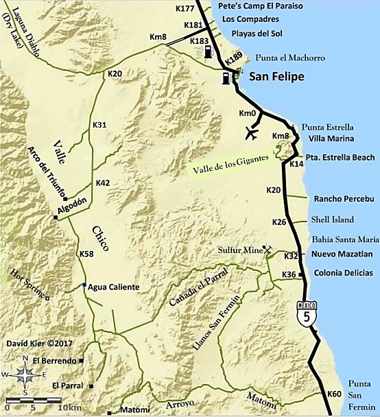
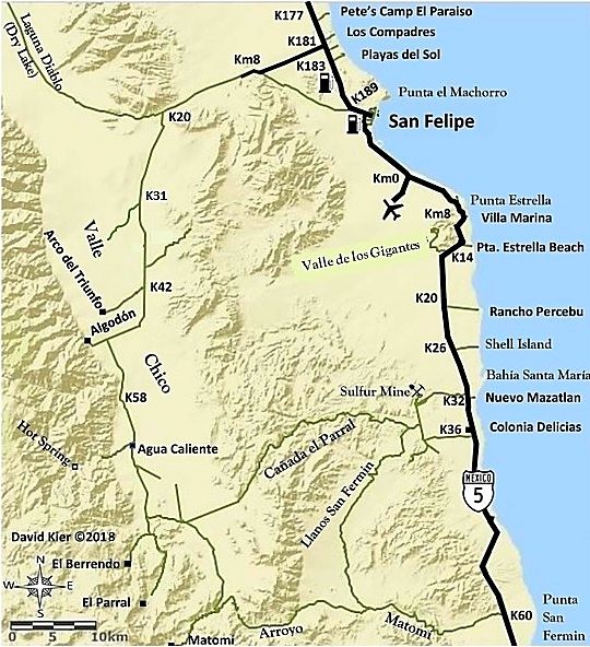
In a final edit (well maybe final) edit of my manuscript, it was discovered I spelled a place with "las" when it should be a "los" (with Gigantes). When I checked my notes, sure enough, I had it correct as los, but when typing, I used "las". That typo error transferred onto my San Felipe map (one of the first I made)... So here is version 5 of the San Felipe Area map with Valle de los Gigantes!


Revised editionof this map...


valle_chico_map_74971.jpg - 219kB

[Edited on 7-12-2018 by David K]

4x4abc - 7-9-2018 at 01:55 PM

about the Visita San Isidoro - the topo maps list it as San Isidro.
Which one is correct?
Google does not seem to know it at all

David K - 7-9-2018 at 03:25 PM

Isidoro
You have my book, Harald: Page 160, and a photo of it from TW (TMW) is on page 216.

Edit:

I Googled "Visita San Isidoro", and got Nomad geoffff's post with the Almanac (which comes from Mexican topos) map showing 'Isidoro': http://octopup.org/baja2016/san-isidoro


[Edited on 7-9-2018 by David K]

David K - 7-9-2018 at 03:37 PM

More:
It was named by Padre Juan Crespí [on the expedition from Loreto to San Diego], on April 4, 1769, which was the day of that saint. Crespí considered it "an excellent spot for founding a good-sized mission."

Crespí spells it 'Ysidoro' but he also spells 'San Ygnacio' mission.

San Isidoro was the first place of several named by Crespí to survive to modern times.

The Saint: https://www.franciscanmedia.org/saint-isidore-of-seville/

[Edited on 7-9-2018 by David K]

4x4abc - 7-9-2018 at 05:03 PM

Gracias, David!

David K - 7-9-2018 at 05:13 PM

My pleasure! :bounce::bounce::bounce:

PaulW - 7-9-2018 at 08:04 PM

The road at K181 is paved to KM10. Past the dump road and around the curve

David K - 7-9-2018 at 08:08 PM

Quote: Originally posted by PaulW  
The road at K181 is paved to KM10. Past the dump road and around the curve


Yes, thanks Paul... I have revised the San Felipe map to show that... the newer one was shown in another post.

Russ - 7-10-2018 at 05:02 AM

Good work Amigo;)
Oh, I use to be able to drag and drop those maps to my computer but these I couldn't?

[Edited on 7-10-2018 by Russ]

norte - 7-10-2018 at 08:28 AM

There is no such place with the formal name of "shell Island".:biggrin:

David K - 7-10-2018 at 09:52 AM

Quote: Originally posted by norte  
There is no such place with the formal name of "shell Island".:biggrin:


You are correct! :biggrin:
The same thing with 'Shell Beach', 'The Widowmaker', 'Scorpion Bay', 'Shipwrecks', and on and on...

"The barrier island between Percebu and Bahia Santa Maria" was just too much to say, so I came up with "Shell Island", in 1978! :light:

David K - 7-10-2018 at 09:55 AM

Quote: Originally posted by Russ  
Good work Amigo;)
Oh, I use to be able to drag and drop those maps to my computer but these I couldn't?

[Edited on 7-10-2018 by Russ]


They are all posted in the Road Conditions forum. http://forums.bajanomad.com/viewthread.php?tid=88771

If you can't grab them from there, I can email you the files.

bajamary1952 - 7-10-2018 at 10:21 AM

David...Thanks SO MUCH for providing these updated maps & markers. I travel a lot in Baja alone with my dog so these are really helpful considering there are so few map resources (even in Spanish). They will be very useful on my upcoming fall trips.

Russ - 7-10-2018 at 10:33 AM

Thanks. Book marked it:light:

David K - 7-10-2018 at 10:53 AM

Quote: Originally posted by bajamary1952  
David...Thanks SO MUCH for providing these updated maps & markers. I travel a lot in Baja alone with my dog so these are really helpful considering there are so few map resources (even in Spanish). They will be very useful on my upcoming fall trips.


My pleasure. I hope that you will be able to utilize the road logs in the guide, as well. The publishing of it is in the works.

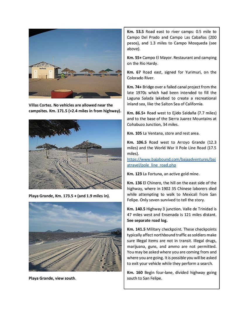
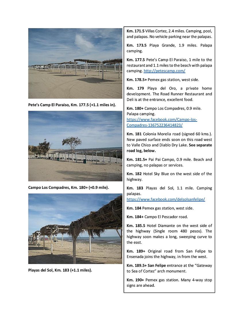
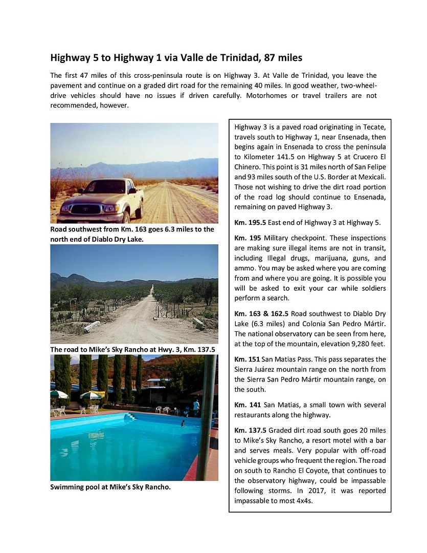
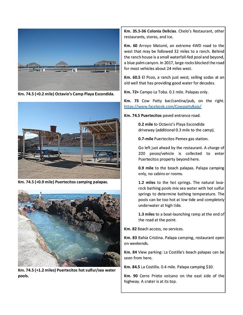
Here are some sample pages (not necessarily the final edited or updated version, just worksheets):


Cliffy - 7-10-2018 at 10:12 PM

Way better than the old AAA maps and guide book!!!! :-) :-)

David K - 7-11-2018 at 07:03 AM

Thank you... with a life of reading and loving Baja guidebooks, I knew what would be most useful and easy to use. The full guidebook as it is now is 115 pages (8.5x11) and covers all the main roads and many side trips of interest. It is full of photos placed next to or near the text about the place shown. A printed version may be in black & white because of the high cost of color. An online version will be like you see above and you can print it as you wish to take with you.
The guide is made so that it can easily be added to or modified for changes or additions. I have already made edits to reflect the passing of Pancho at San Rafael, the paved road completed to Bahía Tortugas, and any other news I become alerted to. That allows the online version to be as fresh as possible. I traveled over 12,000 miles last year researching for this guide and the GPS map we have, as well. Those research trips are all shared here on Baja Nomad as 'TRIP #1-7' trip reports of 2017. One area I have not yet covered for the guide is the Sierra Juarez (Laguna Hanson) and the west half of Hwy. 3 side trips. So much Baja... so little time!

David K - 7-12-2018 at 04:35 PM

Quote: Originally posted by PaulW  
The road at K181 is paved to KM10. Past the dump road and around the curve


Here is the newer version of the map with paved road to Km. 10:


PaulW - 7-12-2018 at 07:49 PM

Now it agrees with the older map or is there really only one map now?
Nice maps. I am glad you can update them quickly.

David K - 7-12-2018 at 09:10 PM

I have posted it before. This thread is on San Quintin map so the San Felipe map here wasn't updated. All 30 of my maps are in there own thread in the Road Conditions forum. It isn't real quick or easy to change them, but possible.