BajaNomad

Pinnacle route for picacho del Diablo

LukeJobbins - 3-26-2018 at 08:20 AM

Just attempted the pinnacle route to picacho from botte azul. We got shut down half way after running out of water and food and not wanting to survive another night on the mountain.

Anyone have detailed maps and or beta for the route? We want to go again but better prepared and complete the route in one shot.

Thanks

PaulW - 3-26-2018 at 08:36 AM


[Edited on 3-27-2018 by PaulW]

LukeJobbins - 3-26-2018 at 10:41 AM

There is water available at campo noche but nothing at blue bottle and nothing on the ridge except for a puddle in a rock that I thought was pretty dirty looking but we went for it anyways. We had topo maps and satellite images but they did not seem very accurate when I was up there. We got to one point where the climb or scramble up a rock was not worth the risk(+150’ cliff if we fell) without placing gear(we didn’t have). We couldn’t find a way around and didn’t want to get stuck on the other side without gear or water so we ended up backtracking to what we called the Morgan Fox spot(where he was found) and down the canyon to just below the waterfall above campo noche and back up the normal canyon to blue bottle. With our current gps route and info about the first half, we feel confident in dropping the time from a day and a half to a half day for the first half. But we still have no idea about the second half of the route and we want info to make it a bit faster and safer next time.

Maderita - 3-26-2018 at 11:17 AM

Luke,
I can put you in touch with friends from Tijuana who have done the Pinnacle Ridge route from Blue Bottle. I believe they placed protection, encountered some 5.7, and made rappels. Their bivy site was the exact same as where Morgan Fox was found.
-John

woody with a view - 3-26-2018 at 11:20 AM

BajaAndy has done it. A rudimentary search here produced this:
http://forums.bajanomad.com/viewthread.php?tid=39970#pid4335...

PaulW - 3-26-2018 at 12:09 PM


[Edited on 3-27-2018 by PaulW]

LukeJobbins - 3-26-2018 at 01:00 PM

Quote: Originally posted by Maderita  
Luke,
I can put you in touch with friends from Tijuana who have done the Pinnacle Ridge route from Blue Bottle. I believe they placed protection, encountered some 5.7, and made rappels. Their bivy site was the exact same as where Morgan Fox was found.
-John


Yeah please. We made five rappels if I remember correctly. Zero rock climbing, just scrambling but we both agreed it wasn’t the right route when we called the trip. Our friend did the route blue bottle to picacho down to campo noche and back up to blue bottle in one day and said he never had a sketchy area but couldn’t remember details. We took two days for half the route and called it at the sketchy part so we most likely were a bit off route.

Maderita - 3-26-2018 at 02:42 PM

Luke,
I will send an email with the contact info for Alex G. who did Pinnacle Ridge.

Woody and PaulW,
It seems that you may be confused about Luke's intended route, "...pinnacle route to picacho from botte azul".
He is referring to the technical route that is commonly called "Pinnacle Ridge". It is the very long granite ridge consisting of numerous rocky spires that connects Cerro Botella Azul (aka: Blue Bottle peak) with Picacho del Diablo. That route does not involve descending into Diablo Canyon. I have no reason to expect there would be water up on that ridge, except after snow or rain.

David K - 3-26-2018 at 03:04 PM

Quote: Originally posted by Maderita  
Luke,
I will send an email with the contact info for Alex G. who did Pinnacle Ridge.

Woody and PaulW,
It seems that you may be confused about Luke's intended route, "...pinnacle route to picacho from botte azul".
He is referring to the technical route that is commonly called "Pinnacle Ridge". It is the very long granite ridge consisting of numerous rocky spires that connects Cerro Botella Azul (aka: Blue Bottle peak) with Picacho del Diablo. That route does not involve descending into Diablo Canyon. I have no reason to expect there would be water up on that ridge, except after snow or rain.


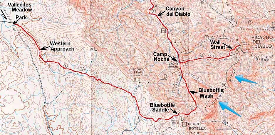
Blue arrows pointing out Pinnacle Ridge:


Maderita - 3-26-2018 at 07:34 PM

Thanks for posting the map David.
I've been curious about the "new" western approach route from Vallecitos meadow to Scout Peak and dropping from Scout Peak to Campo Noche. Not curious enough to actually do it though!
The old route was from Los Llanitos (at the end of the dirt "road" leading south from Vallecitos) to Blue Bottle and down Gorin's Gully (or the adjacent gully or rib).
The new route looks easier. Perhaps more mileage, but some of that over easier terrain. Any way you do it, that mountain is a long grind.

bajaandy - 3-26-2018 at 07:53 PM

Hey Woody... thanks for the nod, but I haven't done the Pinnacle Ridge route. I've done the normal route down to Campo Noche and then to the summit and back.

Good luck on your next attempt Luke! I'm sure you'll get it next time!

JZ - 3-26-2018 at 08:23 PM

Where is this at?

mtgoat666 - 3-26-2018 at 09:59 PM

Quote: Originally posted by JZ  
Where is this at?


Baja
Parque Nacional Sierra de San Pedro Mártir
Picacho del diablo

Google it up

BajaGringo - 3-27-2018 at 08:09 AM

Quote: Originally posted by LukeJobbins  
Just attempted the pinnacle route to picacho from botte azul. We got shut down half way after running out of water and food and not wanting to survive another night on the mountain.

Anyone have detailed maps and or beta for the route? We want to go again but better prepared and complete the route in one shot.

Thanks


I would contact Victor Lopez (Rayo Ensenada), one of the most experienced guides for that area I know and has been involved in several rescues of stranded hikers on the mountain. You may recall the emotional video last year of the rescue of a SoCal father along with his two daughters on the mountain - Rayo was the first one to reach them. You can contact him via facebook.

U2u me I can send you his cell number...

https://www.facebook.com/rayo.ensenada

Rayo Ensenada 2.jpg - 198kB


[Edited on 3-27-2018 by BajaGringo]

David K - 3-27-2018 at 08:12 AM

Ya, it's like the tallest mountain in Baja, JZ... and it is labeled on the map I posted.... straight west from San Felipe, the double peak/tallest mountain, Picacho del Diablo, 10,154'.


[Edited on 3-27-2018 by David K]

LukeJobbins - 3-27-2018 at 08:41 AM

Quote: Originally posted by BajaGringo  
Quote: Originally posted by LukeJobbins  
Just attempted the pinnacle route to picacho from botte azul. We got shut down half way after running out of water and food and not wanting to survive another night on the mountain.

Anyone have detailed maps and or beta for the route? We want to go again but better prepared and complete the route in one shot.

Thanks


I would contact Victor Lopez (Rayo Ensenada), one of the most experienced guides for that area I know and has been involved in several rescues of stranded hikers on the mountain. You may recall the emotional video last year of the rescue of a SoCal father along with his two daughters on the mountain - Rayo was the first one to reach them. You can contact him via facebook.

U2u me I can send you his cell number...

https://www.facebook.com/rayo.ensenada


[Edited on 3-27-2018 by BajaGringo]


Thanks. I’ll ask Sofia about him. She was part of the rescue party so I’m sure she knows him.