BajaNomad

SERGIO

 Pages:  1  

bajabuddha - 10-2-2018 at 12:55 PM

Hurricane Sergio is headed out to sea according to wunderground, which only projects the next 5 days. However, windyty is showing a future U-turn next week and the storm picking up more force, and heading right back towards Baja. Gonna be worth keeping an eye on for sure... I hope they're wrong.

woody with a view - 10-2-2018 at 02:21 PM

Wierd track but this model is only accurate within 100 hours.
Check back on Friday.

http://www.stormsurfing.com/cgi/display.cgi?a=npac_height

AKgringo - 10-2-2018 at 02:52 PM

For what it is worth, the long range forecast for the European model (ECMWF), and the NOAA (GFS), are remarkably similar this time!

https://www.windy.com/?2018-10-12-00,20.386,-96.372,4

It would be interesting to see a hurricane make almost a U-turn after a week at sea!

woody with a view - 10-2-2018 at 03:10 PM

Fwiw, early season storms tend to head west or north west. Late season storms appear to be affected by the Coriolis Effect and bend into land.

YMMV

bajabuddha - 10-3-2018 at 03:36 PM

As of now windyty.com has ol' Sergio headed right for Shari's by Friday the 12th. Again, hope they're wrong, but now's the time to stay alert and keep the third eye on him. Never seen a storm do a U-ey before. Suerte to all.

woody with a view - 10-3-2018 at 04:57 PM

10 days is forever. Does’t hurt to keep an eye on it. Check back after Monday.

shari - 10-4-2018 at 08:07 AM

Oh for Pete's sakes.....really Sergio??? Oh well...my garden is already toast anyway...shrug.

shari - 10-4-2018 at 09:26 AM

this is what windy.com predicts for next week at this time...dang...

SErgio.jpg - 28kB

blackwolfmt - 10-4-2018 at 11:38 AM

What a crazy turn I think Sergio has a mind of his own

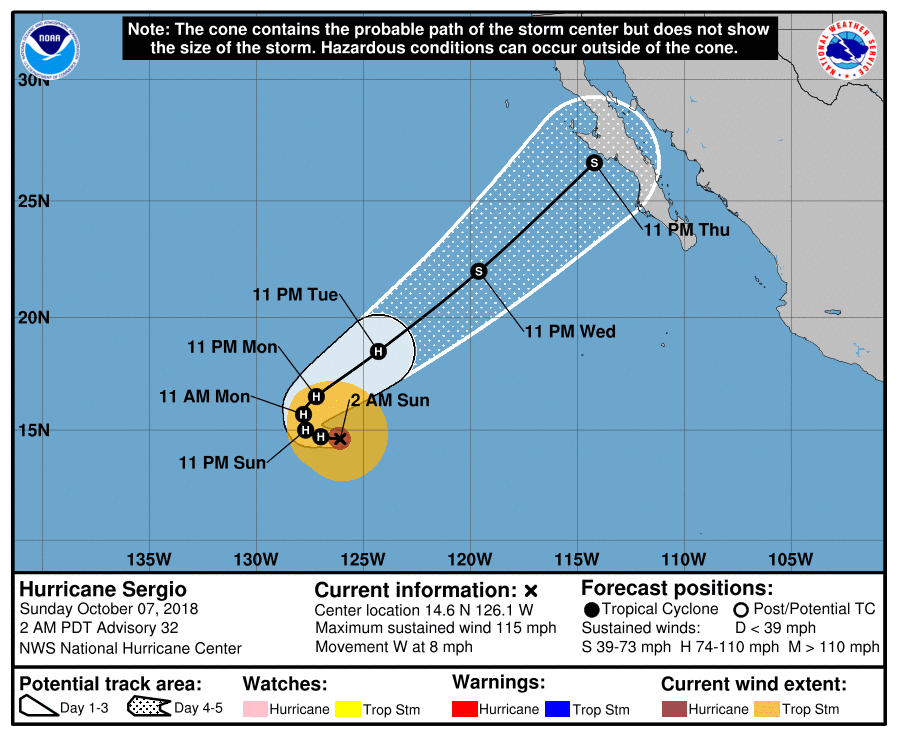
144621_5day_cone_no_line_and_wind.png - 55kB

willardguy - 10-4-2018 at 11:45 AM

yo sergio........R O S A R I T O

we is DRY!

AKgringo - 10-4-2018 at 11:49 AM

Sergio is upset because Rosa left him. He heard that she was headed toward Guerrero Negro, and is hot on her trail!


[Edited on 10-4-2018 by AKgringo]

Bob and Susan - 10-4-2018 at 04:38 PM

predictions for next Friday don't look good...

fri4pm.jpg - 78kB

shari - 10-4-2018 at 04:52 PM

whoa...maybe Rosa was just a dress rehearsal....rut roh

mtgoat666 - 10-4-2018 at 11:03 PM

Quote: Originally posted by bajabuddha  
Hurricane Sergio is headed out to sea according to wunderground, which only projects the next 5 days. However, windyty is showing a future U-turn next week and the storm picking up more force, and heading right back towards Baja. Gonna be worth keeping an eye on for sure... I hope they're wrong.


Wunderground and windyty are pretty crappy for anything 3+ days out, but more reliable NWS forecasts show Sergio moisture coming up thru SOC into AZ... however analysis shows uncertainty that many days out,...
But could be Rosa part deux.

David K - 10-5-2018 at 07:48 AM

Quote: Originally posted by shari  
whoa...maybe Rosa was just a dress rehearsal....rut roh


Did you like the Jetson's?

8 AM Today (Friday)

SFandH - 10-5-2018 at 08:18 AM

000
WTPZ31 KNHC 051448
TCPEP1

BULLETIN
Hurricane Sergio Advisory Number 25
NWS National Hurricane Center Miami FL EP212018
800 AM PDT Fri Oct 05 2018

...SERGIO MOVING WESTWARD OVER THE OPEN EASTERN PACIFIC...


SUMMARY OF 800 AM PDT...1500 UTC...INFORMATION
----------------------------------------------
LOCATION...15.9N 121.8W
ABOUT 915 MI...1470 KM WSW OF THE SOUTHERN TIP OF BAJA CALIFORNIA
MAXIMUM SUSTAINED WINDS...115 MPH...185 KM/H
PRESENT MOVEMENT...W OR 280 DEGREES AT 8 MPH...13 KM/H
MINIMUM CENTRAL PRESSURE...959 MB...28.32 INCHES


WATCHES AND WARNINGS
--------------------
There are no coastal watches or warnings in effect.


DISCUSSION AND OUTLOOK
----------------------
At 800 AM PDT (1500 UTC), the eye of Hurricane Sergio was located
near latitude 15.9 North, longitude 121.8 West. Sergio is moving
toward the west near 8 mph (13 km/h). A turn toward the
west-southwest is expected Saturday followed by a turn back to the
west on Sunday. Afterward, Sergio is forecast to turn toward the
northwest and north-northwest early next week.

Maximum sustained winds have decreased to near 115 mph (185 km/h)
with higher gusts. Sergio is a category 3 hurricane on the
Saffir-Simpson Hurricane Wind Scale. Additional slow weakening
is forecast during the next several days, but Sergio is expected to
remain a hurricane through the middle of next week.

Hurricane-force winds extend outward up to 45 miles (75 km) from the
center and tropical-storm-force winds extend outward up to 175 miles
(280 km).

The estimated minimum central pressure is 959 mb (28.32 inches).


HAZARDS AFFECTING LAND
----------------------
None.


NEXT ADVISORY
-------------
Next complete advisory at 200 PM PDT.

AKgringo - 10-5-2018 at 05:17 PM

If you select the rain forecast on the Windy site, it looks like Bahia Asuncion could get pretty wet in just about a week! (3.78 inches)

I know, I know....a week out is a pretty iffy prediction, but it fascinates me!

https://www.windy.com/-Rain-thunder-rain?gfs,rain,2018-10-11...


[Edited on 10-6-2018 by AKgringo]

blackwolfmt - 10-5-2018 at 05:36 PM

Quote: Originally posted by AKgringo  
If you select the rain forecast on the Windy site, it looks like Bahia Asuncion could get pretty wet in just about a week! (3.78 inches)

I know, I know....a week out is a pretty iffy prediction, but it fascinates me!

https://www.windy.com/-Rain-thunder-rain?gfs,rain,2018-10-11...


[Edited on 10-6-2018 by AKgringo]


I hear ya Amigo, I think the jet stream next week is going too help drag him north that's my prediction..
BTW i am in No way affiliated with the GOAT meteorological service

ehall - 10-5-2018 at 05:45 PM

Another nothing burger? Lol

Alm - 10-5-2018 at 06:50 PM

Quote: Originally posted by ehall  
Another nothing burger?

Who knows... Burgers or not, Goat is right now - it is difficult to tell much outside of 72 hours. No matter what website, it's just too early yet.

Windy shows rain and wind on some time Thursday. 2pm report by eebmike/NOAA shows yet more sharp U-turn than before, with center of the cone shifting South of BA.

mtgoat666 - 10-5-2018 at 07:12 PM

Quote: Originally posted by Alm  
Quote: Originally posted by ehall  
Another nothing burger?

Who knows... Burgers or not, Goat is right now


Of course I am ! Have I ever been wrong?

Goat, Goat, Goat

John M - 10-5-2018 at 09:00 PM

Surprisingly or not Goat, once again your spell check malfunctioned -

You likely typed in "Have I ever been right?" and it came out on Nomad written as "have I ever been wrong?" egads!

JM


shari - 10-6-2018 at 08:00 AM

Baja Gypsy and I are doing the Jungle Boogie today trying to get Sergio to... Get Down...Get Down!!!!

ON a serious note...no really...Rosa caused me a teeny bit of concern that if the swells got a bit bigger and the tide was higher....things could get a bit tense out here on the rock.

We didnt board up windows as we only anticipated a bit more than 30 knots which isnt that bad but when the wind exceeded about 45 I did get a wee bit nervous. Tarps over my garden work fine up to about 35 knots then shred...which resulted in this sad sight of what was a luscious jungle the day before.

We were lucky here last week...and I sure hope our get down and get funky hurricane dance works to convince Sergio to get down! (my apologies to all those down south in harms way)

IMG_20181003_105146192.jpg - 68kB

Mexitron - 10-6-2018 at 08:20 AM

Poor plants! Is it the wind or salt or both? I use sunshade fabric for tarping my work truck, great at deflecting wind without shredding but it is of course not waterproof.

bajabuddha - 10-6-2018 at 12:34 PM

More news from ol' Sergio:

https://www.msn.com/en-us/weather/topstories/hurricane-sergi...

Windyty now has eyefall just south of San Ignacio lagoon area late Thursday night/Friday morning (all subject to change) and looks like very heavy hit to Mulege down to Loreto. Batten down the hatches, stock up on 'stuff', looks like a soaker. Seems we in southern NM are gonna get it too right after Baja.

Suerte all.

Alm - 10-6-2018 at 06:46 PM

Mulege Friday - max 30 knots per ECMS model, 40 knots per GFS. Not much rain. Looks like BA and BOLA will get soaked more. We are still outside of 2-3 day accurate forecast.

BajaBlanca - 10-7-2018 at 02:22 AM

go away go away

Rosa did NOT go to Guerrero Negro! She is out at sea, so you can just stay there with her and leave us alone.

Who does a U-turn anyway???? jeez.

Russ - 10-7-2018 at 05:24 AM


chuckie - 10-7-2018 at 05:47 AM

The route Russ just posted seems to be the most favored.....YIKES

Alm - 10-7-2018 at 04:02 PM

Yeah, U-turns are not frequent. The path seems to be BA to BOLA, heavier winds in BA, as usual.

Big discrepancy btw US and Euro model for rain accumulation this time. Does anybody remember how much water Odile dumped over a day - or 2, or 3?

woody with a view - 10-7-2018 at 05:03 PM

A metric butt-ton!

That’s an engineering term, BTW.

thebajarunner - 10-8-2018 at 09:59 AM

Thanks for all of the good info on Sergio
We are going to Cabo SL this coming Saturday and you Nomads are way ahead of the conventional news and weather sources for up to date info.
Keep it coming, por favor

(And send Sergio out to the far Western Pacific, if you can)

Hurricane Sergio, Pacific, 2018 Oct 08, Google Earth forecast tracks

V6G3B7 - 10-8-2018 at 12:21 PM

Hurricane Sergio, Pacific, 2018 Oct 08, Google Earth forecast tracks. Three active systems today ... 2 Atlantic & 1 Pacific.

Multiple computer-model tracks are in close agreement, going across (???) ... Bahia de los Angeles, Guererro Negro, Bahia Tortugas, Bahia Asuncion, Vizcaino, La Bocana, Punta Abreojos, San Ignacio, Santa Roasalia, Punta Chivato, Mulege.


Larger Image


Larger Image


Larger Image


[Edited on 10-8-2018 by V6G3B7]

shari - 10-8-2018 at 05:13 PM

chit

AKgringo - 10-8-2018 at 06:05 PM

Quote: Originally posted by shari  
chit


Well Shari, it looks like Sergio is aiming right at you, and it is going to be wet and windy. But then again, it could pass a little to the north or south of you, and it will be wet, and windy!


Alm - 10-8-2018 at 06:11 PM

It's coming, slowly. Cold Pacific water that everybody was complaining on, is stealing its strength. Still, coming. Thursday evening probably.

shari - 10-8-2018 at 06:19 PM

my crystal ball says that Sergio will be seduced by warmer sexier water down south of us....Mag Bay or Scorpion Bay. Asuncion is too cool man:cool:

woody with a view - 10-8-2018 at 06:54 PM

Look at the bright side. At least you don’t have to worry about the plants this time around!😮

bajabuddha - 10-9-2018 at 01:53 AM


* SARCASM ALERT ! *

Watch out for the storm Serge ! (pun inended)

* SARCASM ALERT ! *

chuckie - 10-9-2018 at 03:04 AM

OH MY!

SFandH - 10-9-2018 at 04:28 PM

Colorful: https://www.windy.com/?20.982,-108.809,5

AKgringo - 10-9-2018 at 05:24 PM

At least it appears that the system will pass over Baja rather quickly. It would be a whole different consequence if a storm parked over the area like Florence did on the east coast!

Hook - 10-9-2018 at 06:33 PM

Most recent update now has it at tropical storm status. About 24 hours earlier than predicted. Path is still the same.

Alm - 10-9-2018 at 06:42 PM

It will be rain that will do most damage this time, and it will not go fast. Straight 18 hours of rain in BOLA. Total rain accumulation varies btw the 2 models, one reads 8mm and another one 50mm.

BA will get 1.5 times water - 28 hours straight and 20-80mm accumulation.

Slight change of course in the next 2 days is possible.


Hook - 10-9-2018 at 08:44 PM

18 hours of precipitation producing 8mm would have to be the longest DRIZZLE in the history of Baja. OK, I'm exaggerating............

But seriously, accumulations of 8mm or 50 mm or 20-80 mm are nothing. I think your units must be wrong. Do you mean cm?

[Edited on 10-10-2018 by Hook]

Alm - 10-9-2018 at 11:12 PM

Nope, mm. That's what I see on Windy page -> rain accumulation -> 3 days. Rain begins Thursday afternoon in BA, Friday 1am in BOLA, and ends Friday evening.

Out of those long hours of rain, only ~1/3 of time rain is expected to exceed 8 mm/hr by GFS model.

8 mm/hr is a heavy rain, but their totals don't make sense. For example, in BOLA there will be 7 hours with more then 8mm per hour, including few hours with over 15mm/hr - this is a VERY heavy rain. Adds up to more than 60 mm total. Plus some drizzle 0.1-7.9 mm/hr the rest of the time. Should be 90-100 mm total. But it says only 50 mm total.

ECMF model predicts a weaker rain and less total accumulation.

[Edited on 10-10-2018 by Alm]

Russ - 10-10-2018 at 07:34 AM

I put off any predictions but now that is a lot closer I urge everyone to be prepared for some tropical storm dangers. Most of you know the drill so I won't get into that. Please check on your neighbors and help where you are able. I'll report from here as long as I have internet service. I think those that aren't going thru a storm worry more than those involved so post info to help them with their worries.

Russ - 10-10-2018 at 09:26 AM

800 AM PDT Wed Oct 10 2018

The cloud pattern associated with Sergio has not changed very much,
and it consists of a cyclonically curved convective band surrounding
a large and ragged eye feature. Since the convection is weaker, the
Dvorak estimates suggest that winds are gradually decreasing, and
the initial intensity has been lowered to 55 kt. Some fluctuations
in intensity are likely during the next 12 to 24 hours while the
cyclone is still moving over relatively warm waters and is embedded
in a low shear environment. Both of these factors will become
unfavorable soon, and consequently, the NHC forecast calls for
weakening. Sergio, however, is expected to still be a tropical
storm by the time it approaches the Baja California peninsula. After
that time, Sergio will move over mainland Mexico and weaken much
faster.

Sergio is moving toward the northeast or 055 degrees at 11 kt. The
cyclone is embedded within the southwesterly winds associated
with a large mid-latitude trough, and this flow pattern will
continue to steer Sergio toward the northeast with an increase in
forward speed. The forecast track brings the center of a weakened
Sergio over the central portion of the Baja California peninsula in
about 2 days, but winds along the coast are anticipated to increase
earlier. Track models are in very good agreement, and consequently
the guidance envelope is quite tight. The NHC forecast is not
different from the previous one and is in the middle of the guidance
envelope.

Alm - 10-10-2018 at 09:33 AM

Rain totals have been adjusted upwards overnight.
It is now 90mm for BA (both models in agreement) and 16-60mm for BOLA (discrepancy between 2 models, probably because it's hard to predict how mountain terrain will affect it).

Total duration of rain remains about the same, +24 hrs for BA, +18 hrs for BOLA.

Hook - 10-10-2018 at 09:39 AM

Quote: Originally posted by Alm  
Nope, mm. That's what I see on Windy page -> rain accumulation -> 3 days. Rain begins Thursday afternoon in BA, Friday 1am in BOLA, and ends Friday evening.

Out of those long hours of rain, only ~1/3 of time rain is expected to exceed 8 mm/hr by GFS model.

8 mm/hr is a heavy rain, but their totals don't make sense. For example, in BOLA there will be 7 hours with more then 8mm per hour, including few hours with over 15mm/hr - this is a VERY heavy rain. Adds up to more than 60 mm total. Plus some drizzle 0.1-7.9 mm/hr the rest of the time. Should be 90-100 mm total. But it says only 50 mm total.

Oh, 8mm per HOUR! That's a horse of a different color.

ECMF model predicts a weaker rain and less total accumulation.

[Edited on 10-10-2018 by Alm]

Alm - 10-10-2018 at 09:54 AM

Hook, it "was" 8mm total for BOLA in earlier forecast, as per ECMF model (50mm total per GFS model).
In that earlier forecast ECMF predicted less than 3mm/hr during this period, GFS - more than 8mm/hr at times.

Both models have been adjusted upwards now, - a little more water. I keep my fingers crossed that ECMF is correct @total 16mm.

SFandH - 10-10-2018 at 10:01 AM

1 inch = 25.4 mm

Alm - 10-10-2018 at 10:40 AM

1 mm of rain = 1 liter of water covering one square meter.

These numbers don't tell much. 8 mm/hr means heavy rain, total 80 mm a day means flooded basements and puddles on the road.


BajaDanD - 10-10-2018 at 11:50 AM

We are in Cabo Pulmo and leaving tomorrow morning heading north with a stop in Guerrero negro
Still not sure if we will go up the 5 from Chapala to the border it took us 3 1/2 hours to get from 25k south of San Felipe to Papa Fernandez just north of Gonzaga on Saturday on our way down
We might take the 1 and cross over to Tacate or San Felipe
Hope we can stay ahead of Sergio

Alm - 10-10-2018 at 01:13 PM

Leaving from Cabo on Thursday, you will stay "behind" Sergio, not ahead.

fishbuck - 10-10-2018 at 01:41 PM

Quote: Originally posted by shari  
my crystal ball says that Sergio will be seduced by warmer sexier water down south of us....Mag Bay or Scorpion Bay. Asuncion is too cool man:cool:


I'm sending you a extra coolness beam to help steer the Sergio away from my sacred fishing grounds (your house🙂).
Where do you want it to land?
Not that you need any extra coolness...😉

Hook - 10-10-2018 at 02:25 PM

Quote: Originally posted by Alm  
Rain totals have been adjusted upwards overnight.
It is now 90mm for BA (both models in agreement) and 16-60mm for BOLA (discrepancy between 2 models, probably because it's hard to predict how mountain terrain will affect it).

Total duration of rain remains about the same, +24 hrs for BA, +18 hrs for BOLA.


OK, got it.

That just doesnt seem like much rain to worry about. But I went through one TS (Julio) and one hurricane (Jimena) in Sonora in the first two years I lived there. They dropped 228 mm and 762 mm in 24 hours, respectively.

Alm - 10-10-2018 at 03:25 PM

So how much water did Odile drop, in total 24 hours, for BA or BOLA?

BajaMama - 10-10-2018 at 03:35 PM

Quote: Originally posted by Russ  
I put off any predictions but now that is a lot closer I urge everyone to be prepared for some tropical storm dangers. Most of you know the drill so I won't get into that. Please check on your neighbors and help where you are able. I'll report from here as long as I have internet service. I think those that aren't going thru a storm worry more than those involved so post info to help them with their worries.


Thank you Russ! We are driving out the PC road next Thursday, please post road condition so we can plan accordingly. Hopefully the roof will still be on when we get there!

Russ - 10-10-2018 at 04:14 PM

It appears Sergio has moved a little north over the past hours but the tropical storm warnings are still in effect thru out central baja.

Tropical Storm Sergio Discussion Number 46
NWS National Hurricane Center Miami FL EP212018
200 PM PDT Wed Oct 10 2018

The organization of the cloud pattern has remained unchanged during
the day, except that the deep convection has continued to weaken.
Nevertheless, Dvorak numbers from TAFB and SAB still support an
initial intensity of 55 kt. Some fluctuations in intensity are
likely during the next 12 hours while the cyclone is over relatively
warm waters and is embedded in a low shear environment. Since both
of these factors will become unfavorable in about 12 to 24 hours,
the NHC forecast calls for weakening. Sergio, however, is expected
to still be a tropical storm by the time it approaches the Baja
California peninsula. After that time, Sergio will move over
mainland Mexico and weaken much faster.

Sergio is moving toward the northeast or 050 degrees at 12 kt. The
cyclone is embedded within the southwesterly winds associated
with a large mid-latitude trough, and this flow pattern will
continue to steer Sergio toward the northeast with an increase in
forward speed. The forecast track brings the center of a weakened
Sergio over the central portion of the Baja California peninsula in
about a day and half, but winds will reach the coast a little bit
earlier. Track models continue to be in very good agreement, and
consequently the guidance envelope is quite tight. The NHC forecast
remains unchanged and is in the middle of the guidance envelope.

The primary threat associated with Sergio and its remnants continues
to be life-threatening flash flooding and mudslides within
mountainous terrain in the Mexico states of Baja California Sur,
Sonora, the U.S. Southern Plains, and the Ozarks through the
weekend.

shari - 10-10-2018 at 05:43 PM

Quote: Originally posted by Alm  
So how much water did Odile drop, in total 24 hours, for BA or BOLA?


Odile didnt rain on our parade here in Asuncion...but the Vizcaino Valley got hammered. Today we took a trip to Guerrero Negro and there were many CFE rigs heading to Asuncion, La Bocana, Abreojos so they are braced for action in central Baja.
We heard a rumour that they were thinking of evacuating some areas of Vizcaino as it floods pretty bad with alot of rain.

woody with a view - 10-10-2018 at 05:48 PM

Should be interesting headed down Sat O-dark-3O to BdeLA.

Alm - 10-10-2018 at 05:52 PM

The key words:
...primary threat associated with Sergio and its remnants continues to be life-threatening flash flooding and mudslides within mountainous terrain in the Mexico states of Baja California Sur, Sonora.

("Sur" here really means "Central Baja").

50 knots winds tomorrow at BA, slightly less in BOLA.

mtgoat666 - 10-10-2018 at 06:17 PM

In the past, hurricane rains at Lagoons at camp Rene and San ignacio and Manuela have been followed by a winter season with increase in fish and very large increase in bird populations,... so there is a benefit from all that floodwater flushing the land and nutrients to the lagoons.

chuckie - 10-10-2018 at 06:22 PM

I just there was a pony in there somewhere,,,,

mtgoat666 - 10-10-2018 at 06:25 PM

Quote: Originally posted by chuckie  
I just there was a pony in there somewhere,,,,


Don’t know about ponies, but there are some unicorns :cool:

woody with a view - 10-10-2018 at 07:30 PM

Snowflakes..... 🤣

Edit: hold on tight kiddies!

[Edited on 10-11-2018 by woody with a view]

shari - 10-11-2018 at 06:31 AM

well it started raining before dawn this morning here in Bahia Asuncion....gonna be a wet one dang!
Where else is it raining?
I look forward to live updates and reports....por favor!

DouglasP - 10-11-2018 at 07:14 AM

Got in to Punta Chivato yesterday (hi Russ) afternoon, came down Hwy 1due to reports of 5 being closed North of Gonzaga. Other than the delay south of ensenada for construction, very smooth trip. Waiting for Sergio, will report anything worth reporting.

BajaBlanca - 10-11-2018 at 07:21 AM

Hi Shari


It has been sprinkling here. For sure, you can't call it rain.


No wind at all.

Rocinante - 10-11-2018 at 07:45 AM

I don't post much but have been reading this forum for a couple years. Thought I'd give real time info from last night:
Made it to Ensenada last night about 8:30pm.
Catavina was still working on the deep arroyo which still had water in it. Another arroyo in Catavina was also wet and from there north to Rosario there was several places with standing water on either side of the road.
Then 30 miles from Mandaero(sp?) the road work continues and looks like a it could be a good setup for a landslide with a little rain and wind. Down to one lane. No problems driving it but catavina to Rosario sure doesn't look like its going to take much rain at all to wash it all out again.

[Edited on 10-11-2018 by Rocinante]

BajaBlanca - 10-11-2018 at 08:04 AM

Thanks Rocinante, the up to minute information really does help a lot!

Hook - 10-11-2018 at 08:52 AM

Quote: Originally posted by Rocinante  
I don't post much but have been reading this forum for a couple years. Thought I'd give real time info from last night:
Made it to Ensenada last night about 8:30pm.
Catavina was still working on the deep arroyo which still had water in it. Another arroyo in Catavina was also wet and from there north to Rosario there was several places with standing water on either side of the road.
Then 30 miles from Mandaero(sp?) the road work continues and looks like a it could be a good setup for a landslide with a little rain and wind. Down to one lane. No problems driving it but catavina to Rosario sure doesn't look like its going to take much rain at all to wash it all out again.

[Edited on 10-11-2018 by Rocinante]


The chances are incredibly high that Sergio will impact this area significantly, with rain.

The only good news is that the storm is now moving at 17 kts, incredibly fast. Maybe it will pass quickly............or maybe it will stall over the mtns. of central Baja. Quien sabes?

If you are traveling south on Fri/Sat/Sun, be prepared to wait out arroyos. They will be flowing.

[Edited on 10-11-2018 by Hook]

Russ - 10-11-2018 at 09:30 AM

Just fixed my wind thingy on the weather station! 5mph WNW (unusual). Some light clouds 83º - 54%
baro 29.82in
Can't copy IMGs on photobucket so no photos.


From www.EBMIKE.COM

David K - 10-11-2018 at 09:30 AM


https://www.nhc.noaa.gov/storm_graphics/EP21/refresh/EP21201...

[Edited on 10-12-2018 by David K]

Bob and Susan - 10-11-2018 at 09:38 AM

the "calm" before the storm...
it sure wont be like THIS tomorrow...
picture taken 10:30am Oct 11th

IMG_1757.JPG - 217kB

Alm - 10-11-2018 at 10:06 AM

Relax, Bob, this one is not meant for you.

Eeb/NOAA have corrected the path a little to the South - after it hits the coast at Asuncion. The center is now close to Sta Rosalia (was at Pto S.Francisquito). But the rain is not centered in the eye of hurricane, it's more at the edges/tails of the path. BOLA and Mulege could still get some. Possibly 3-5 hours of heavy rain, with drizzle before and after. We shall see.

SFandH - 10-11-2018 at 10:36 AM

ECMWF model rain prediction for 11 AM Friday (tomorrow). Click in the image to see rain amounts at different locations. 25.4 mm = 1 inch

https://www.windy.com/-Rain-thunder-rain?rain,2018-10-12-18,...


Hook - 10-11-2018 at 10:50 AM

Quote: Originally posted by Alm  
Relax, Bob, this one is not meant for you.

Eeb/NOAA have corrected the path a little to the South - after it hits the coast at Asuncion. The center is now close to Sta Rosalia (was at Pto S.Francisquito). But the rain is not centered in the eye of hurricane, it's more at the edges/tails of the path. BOLA and Mulege could still get some. Possibly 3-5 hours of heavy rain, with drizzle before and after. We shall see.


Has the most recent "fix" upstream on the Rio Mulege ever been tested?

AKgringo - 10-11-2018 at 10:53 AM

Quote: Originally posted by SFandH  
ECMWF model rain prediction for 11 AM Friday (tomorrow). Click in the image to see rain amounts at different locations. 25.4 mm = 1 inch

https://www.windy.com/-Rain-thunder-rain?rain,2018-10-12-18,...


My preferred route south next month includes the stretch of road south of B.O.L.A. If that model holds up, it looks like that road is likely to go through some changes before I get there!

SFandH - 10-11-2018 at 11:00 AM

My current plan is to drive between Guerrero Negro and Mulege on Monday. Hopefully there will be some road reports after the storm blows through.

GLNaeve - 10-11-2018 at 11:29 AM

current plan is to drive San Q to Mulege, Wednesday 18.
keep the reports coming...Thanks

Meany - 10-11-2018 at 12:26 PM

DouglasP&TWFP. Glad to here you got to Chivato just fine. Hope all is well there. Get ready for a lot of wind and some rain. We are leaving from London tomorrow to LA. Stay in touch if you can. Meany

mtnpop - 10-11-2018 at 12:42 PM

Well, a week to 10 days for us, we have been using 5 for 5 or 6 years now and has worked very well for us. will just have to see if Sergio does any more damage that could cause us problems. just hope that this one fizzles.
Hummer H3 should be able to roll thru

Alm - 10-11-2018 at 02:03 PM

Quote: Originally posted by AKgringo  

My preferred route south next month includes the stretch of road south of B.O.L.A. If that model holds up, it looks like that road is likely to go through some changes before I get there!

I've been watching both models for the last few days, - perhaps too much. Right now it looks like both hurricane center and rainfall (two different things) are shifting South of BOLA. The village will probably be spared, less than 40mm total rain accumulation on Friday (this is NOT hourly rate). Roads to the South - not sure.

shari - 10-11-2018 at 02:20 PM

it has been raining pretty steady since predawn in Asuncion...sometimes light and then moderate...gonna find my rain gear & take a booze cruise around town and see how the streets are holding up.

The satellite almost looks like the mass will pass a teeny bit north of us??? I am liking the speeding up of Sergio so it may be just a quickie!

Hook - 10-11-2018 at 07:18 PM

There APPEARS to be a working PWS in Vizcaino, that might give us some interesting results, IF power and internet hold up. It's almost due east of Bahia Asuncion and NW of San Ignacio. Appears to be a decent unit, Davis Vantage Pro2 Plus. It's gotten a little over a .10 of an inch today.

https://www.wunderground.com/personal-weather-station/dashbo...

shari - 10-11-2018 at 07:27 PM

Okay so where else is it coming down like gatos y perros?
the streets of Asuncion are rivers now...the swell is noisier and we have wind of around 18 knots from the east south east I figure...gonna be a very long night

any reports from San Ignacio?

SFandH - 10-11-2018 at 07:50 PM

Don't know where else but thanks for the report. I think there are a bunch of Nomads itching to get down south. Keep us informed if you have the time.

Are people capturing rainwater in any significant quantity?

Alm - 10-11-2018 at 08:22 PM

Shari, the path is from BA to roughly midway btw Pto SF and Sta Rosalia. You are the first on its path. Should start raining on the coast around dawn. Windy page can't make up its mind on the amount of rainfall in BOLA, predictions ranging from 10 to 90 mm total for Friday.

[Edited on 10-12-2018 by Alm]

BajaBlanca - 10-11-2018 at 08:51 PM

wind and steady heavy rain in La Bocana at the moment.

Russ - 10-11-2018 at 11:07 PM

Midnight started raining - no wind, weird - 72º

[Edited on 10-12-2018 by Russ]

MexicoTed - 10-12-2018 at 12:17 AM

Seeing videos of it pouring in Lopez Mateos and Comondu on the internet.

Bob and Susan - 10-12-2018 at 03:48 AM

here on the bay in mulege

its almost 5am

we've had 1 inch of rain

wind 30mph with gusts to 40mph

pretty noisy

too dark to see anything

Russ - 10-12-2018 at 04:15 AM

50mph gust .15” rain no internet phone ok
5:30 Sat image shows that most of the rain clouds have passed us now so hopefully our road is okay this round. Another storm is developing down south so be aware late next week.
Internet up now.

[Edited on 10-12-2018 by Russ]

Juanita - 10-12-2018 at 05:09 AM

Heavier rain began in San Ignacio at 4:30 a.m., after a day of light drizzle. Sure can't sleep through the racket on my tin roof. No wind at all yet, same as Russ reports. Not a 'goose drownder', as I can still see the lights up in the homes on the slope of the mesa. Amazing to have power to report the news.

Russ - 10-12-2018 at 05:38 AM

Stronger sustained winds now 40 to 55 on my station. Folks on the radio saying lots of roofs rattling waiting for daylight to assess any damage. Some also reported roof leaks so my rain gauge may be wrong at only 0.16" since midnight. Hoping the wind will die soon.

DouglasP - 10-12-2018 at 05:43 AM

Looks like our stations match on rain, look what I have for wind!

OI000054_resized.jpg - 158kB

BajaMama - 10-12-2018 at 06:17 AM

Quote: Originally posted by GLNaeve  
current plan is to drive San Q to Mulege, Wednesday 18.
keep the reports coming...Thanks


My suegro and I will be on the road same time, El Rosario to San Ignacio (we like to arrive to Punta Chivato in the AM so we have time to unpack and open the house - anyhow, look for a a burgundy MDX and a white Ford truck, both with Vagabundos signs, and wave hello!

Bob and Susan - 10-12-2018 at 06:37 AM

the wind is howling and the sea is churning

7am pic.jpg - 72kB

 Pages:  1