BajaNomad

San Isidro to Mulege trail

Craig B - 1-22-2019 at 08:53 AM

Some friends and I took our utv's on a ride last week. Started in Loreto and headed to La Purisima. Spent the night then headed to San Isidro in the morning, turned left on the trail to Mulege. Got started later than planned but it was a beautiful day. We made it 40 miles up the trail, had some very rocky sections with a few washouts.

We saw some beautiful country, many ranchos and even a date farm. The placed we stopped was at about 3800 ft. elevation overlooking a very scenic valley. We could see the switch backs going down and the switch backs going up the other side. Looking at the valley below on google earth it was hard to see the road but it was very visible to us.

We had hoped to make it down to the valley and up the other side but thought it best to head back. Our original plan was to turn around anyway and spend another night in La Purisima, just didn't make it as far as we wanted. It will be great if we can make it the whole way as to not be going up the highway traveling between Loreto and Mulege.


Overall was a great ride...

mcnut - 1-22-2019 at 10:15 AM

Thanks, nice report. Myself and several others here have been waiting for an up-to-date report. Please update if you give the rout another go.

Bruce

David K - 1-22-2019 at 11:37 AM

Thank you and hope you try again!

JZ - 1-22-2019 at 01:12 PM

Does it look like it would be easier going East to West?

Can a truck get through the section you went without doing too much climbing over rocks?

Craig B - 1-22-2019 at 01:40 PM

Quote: Originally posted by JZ  
Does it look like it would be easier going East to West?

Can a truck get through the section you went without doing too much climbing over rocks?

The next time we wil try this will probably go from east to west because if there is a problem it will be on the east side of the trail. I don't think it will make any difference as far as difficulity.

There is no way to bypass the rock sections, they are very rough. A serious 4X4 should be able to do it and it would be hell on a bike in my opinion. But then maybe a bike could somehow bypass the rock section by blazing his own trail?

StuckSucks - 1-22-2019 at 02:02 PM

Quote: Originally posted by Craig B  
Overall was a great ride...


Photos to share?

TMW - 1-22-2019 at 06:05 PM

This trail is one of the great trails in Baja when it goes thru all the way. Another is the No Wimp Trail which it appears is now closed off at the north end. I've been both ways on both trails and I look forward to my next trip down there. I would also rate the run out to Timbabichi as an excellent trip to take.

MulegeAL - 1-22-2019 at 06:48 PM

TMW,
Would be happy to do this ride with you Feb/Mar if you are around.
I've done it several times, both directions. Did the Chupparosa end last year, but ran out of day to get to the Guahademi end. South side of that is very rough as reported here. North side is merely muy mallow.

Need a strong skilled rider with good self recovery/self rescue skillset for this one.

motoged - 1-22-2019 at 07:26 PM

Al,
I am in Asuncion until March 6th....and have two weeks where I want to do more riding somewhere on the 450...what are you thinking here ...? Sounds like you are in Mulege.

Craig B - east to west eh?

John M - 1-22-2019 at 07:45 PM

You wrote:

"The placed we stopped was at about 3800 ft. elevation overlooking a very scenic valley. We could see the switch backs going down and the switch backs going up the other side. Looking at the valley below on google earth it was hard to see the road but it was very visible to us."

We went from Mulege to San Isidro in March 2016. Where you stopped at the overlook is really a great viewpoint. Having come from the Mulege side, we had the opposing view - equally beautiful. In my opinion the switchbacks either direction are slow and rocky, and we were way better off in low range, low gear in my Tacoma - I actually felt as though I had some degree of control. Approaching from the Mulege side as you propose, you will encounter a place or two where a GPS might be helpful, or a knowledge of which way to go.

The approach to the "overlook" from the Mulege side is quite rocky for the better part of a mile or two. Slow going, but fun.

TMW knows of what he speaks, at least on this route! Hi Tom!

John M

p.s. some time ago there was a video on Nomad of three or four guys in a way overloaded Toyota taking this route east to west.


[Edited on 1-23-2019 by John M]

Craig B - 1-22-2019 at 08:09 PM

John M
That video you spoke of really got us excited to try this trail. We are planning to go again in the near future..

the video

John M - 1-22-2019 at 08:39 PM

Craig, from the outset while watching the video I didn't think it was the same trail. They had lush vegetation through much of their drive - we did an early springtime drive and it was fifty shades of brown. But it WAS the trail as we recognized a number of sights along the way.

John

JZ - 1-22-2019 at 08:43 PM

Quote: Originally posted by Craig B  


A serious 4X4 should be able to do it and it would be hell on a bike in my opinion.


I question this comment. Generally a bike can ride over a lot more rocks than any 4x4.


Craig B - 1-22-2019 at 08:54 PM

Quote: Originally posted by JZ  
Quote: Originally posted by Craig B  


A serious 4X4 should be able to do it and it would be hell on a bike in my opinion.


I question this comment. Generally a bike can ride over a lot more rocks than any 4x4.
Not trying to offend you or any other moto guys. Years ago I rode a lot, I am glad I was not doing the rocky section on two wheels. Some of you guys could maybe do it easily...

MulegeAL - 1-23-2019 at 09:37 AM

TMW/motoG,
I am thinking I need a strong bike/rider to do this loop with in case something doesn't go to plan. It's 155 miles round from my place here to San Isidro jct, out to hwy 1, and back to Mulege.

Last time I did it clockwise, which puts the sun to my back for most of the rough stuff, and the scenic ride north from San Isidro into the Guajademi cactus forest valley. Also allows me to carry a gallon south and dump that in the tank at the Hwy 1 turnoff. That avoids a gas stop in La Purisima, saves time/daylight.

The rough top section above the rancho Guajademi junction is eroded roadbed, no soil left, just rough mountain bedrock with a bunch of bread-loaf sized loose ones to skip around and over. Cambers hard to one side too.

The climb up and drop in to Las Chuparrosas canyon is OK on the south side and a loose challenging decent on the north. The local rancho guys are going over into the valley, seen their tracks.

Timing-wise I can do this in about a weeks time, other things going on here. Say, from Feb 1 on, anytime during first half of Feb, after that hosting guests here.

We got space for RV's/rigs here, or down the street at Don Chano's RV camp. Good place to kick off a grande loop with a couple good riders.

What say you moto-hombres?

[Edited on 1-23-2019 by MulegeAL]

motoged - 1-23-2019 at 10:47 AM

Al,
Sounds like an experienced plan....however, one week from now is too early for me...(bummer)....thanks for the reply....have fun, whoever goes...

I will be exploring Malarrimo next week....several approaches to be considered....:coolup:

TMW - 1-23-2019 at 12:11 PM

Al I don't ride bikes anymore I gave them all to my son and grandson in CO. I sure miss my XR250, it was setup perfect for me. But as someone said with age comes a cage and I'm happy with my Tacoma. Anyway my next trip to Baja appears to be April 12th. If we have time we may swing down to Mulege and try the trail to San Isidro. The last time in 2016 with John M I tried my best to get us lost but he wasn't having any of that. Party pooper.

Craig B - 1-23-2019 at 12:18 PM

Quote: Originally posted by StuckSucks  
Quote: Originally posted by Craig B  
Overall was a great ride...


Photos to share?


San Isidro to Mulege 1.jpeg - 59kB


Here are a few

San Isidro to Mulege 2 resize.jpg - 44kB San Isidro to Mulege 5resize.jpg - 176kB

TMW - 1-23-2019 at 12:59 PM

for those interested here are two trip reports I did that include the Mulege to San Isidro trail. The first is San Isidro to Mulege and the second is Mulege to San Isidro. The fist also includes the Timbabichi run.

April 2012 http://forums.bajanomad.com/viewthread.php?tid=60000

April 2016 http://forums.bajanomad.com/viewthread.php?tid=83006

[Edited on 1-23-2019 by TMW]

MulegeAL - 1-23-2019 at 04:34 PM

TMW, well darn! Was hoping you were still riding motos down here.
Will keep the lights on for you, but likely back Norte by the time you show up here.

Will keep looking for a strong combo for this loop, or may just solo it again. Then nobody has to eat my dust.

DouglasP - 1-23-2019 at 04:45 PM

Does any one have a GPX or KML file they would like to share?

Hey MulegeAl, we have a place in Punta Chivato and I have it loaded up with toys at this point. I've got a KTM 450 XC-W and a KTM 400 XC-W. I would love to join you on a moto run sometime. I'm a little worried about how our skill sets line up. I have been on both sides of that before. Folks that can't ride as good as they say and folks that expect too much from a rider they aren't familiar with. I would hate to get in over my head way out and have things go wrong.
I would be available around the time frame you are looking at. I have a Can-Am side by side that is pretty capable. 32" tires, lockers, front and rear. Maybe do a bike and side by side run?


Mavricko (1).jpg - 91kB

Tacoma in Baja: Mulegé to San Isidro and west.

David K - 1-23-2019 at 05:37 PM

Quote: Originally posted by John M  
Craig, from the outset while watching the video I didn't think it was the same trail. They had lush vegetation through much of their drive - we did an early springtime drive and it was fifty shades of brown. But it WAS the trail as we recognized a number of sights along the way.

John


Here is that video: https://vimeo.com/146502907

JZ - 1-23-2019 at 05:40 PM

Here you go Doug.


Attachment: Rt Mulege to San Isidro.kmz (15kB)
This file has been downloaded 344 times


MulegeAL - 1-24-2019 at 08:43 AM

DougP,
Hey small world, we just did a 70 mile loop through your 'hood a couple days ago, bombing most of the good sandy 2-track behind P Chivato. We have done the big loop out to Mission Guadelupe/San Jose de M twice this month.

I totally get what your saying about expectations, been through that myself. I say lets hook up for an out and back day ride and have some fun before we tie the knot on a long tuff loop. Could go play tomorrow the 25th, we got plans after that for a while.

KurtG - 1-24-2019 at 09:22 AM

I feel really fortunate that Kathy and I were able to drive the San Isidro/Mulege route in our Explorer 6 years ago. At that time it was rough but no problems. The scenery back there is great.

Al, in November I drove the Mulege/Guadalupe loop. Really happy to have it open again, been one of my favorites for many years.

DouglasP - 1-24-2019 at 09:41 AM

Oh man, that loop sounds like fun. We are brand new to the area still. Bought the place early last year and have been slowly getting things set up. Steve (Meany on here) and Shannon"s place. Life has been getting in the way a lot though.
Won't be able to get together tomorrow, we are still in Idaho until Sunday. Flying in Sunday evening with a couple CV axles for my Toyota. Guess I shouldn't be jumping this thing, LOL.

Let's look at something that following week (1/28-1/31), maybe. Driving down to Cabo the week after that, but wide open after that.

Looking forward to hitting some trails with you.


0107191110-HDR.jpg - 65kB 0107191111.jpg - 73kB 0108191624a.jpg - 55kB

DouglasP - 1-24-2019 at 10:34 AM

Quote: Originally posted by JZ  
Here you go Doug.


Thanks JZ. It loaded right up in BCN and Gaia.

MulegeAL - 1-24-2019 at 11:01 AM

Toyota axles in the overhead bin? Sounds like something I'd do.

No problema, I'll be around.

DouglasP - 1-24-2019 at 04:00 PM

That and wheel travel limit straps and some weld on mounts should make for an interesting time in customs at the Loreto airport.

Craig B - 2-26-2019 at 12:40 PM

Some friends and I just did a five day ride in our utv's. The ride included the Guadalupe ruins loop and Mulege to San Isidro. So it is clear, our lead car had to move a few large rocks to get through at one point in order to get up the hill.
It was quite cold and windy but a beautiful trip.

TMW - 2-26-2019 at 02:13 PM

Great news, thanks Craig.

Jinete Viejo - 2-26-2019 at 11:06 PM

Craig B, just to confirm, your Mulege to San Isidro route went through Guajademi wash?

David K - 2-26-2019 at 11:46 PM

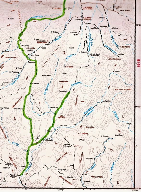
The auto road from San Isidro to Mulegé does not pass the site of Guajadimi, it goes to the northwest of it, leaving Arroyo Guajademi near Agua Grande (northbound).

A road does go to Guajademi but ends there for autos. This is a branch of El Camino Real and only mules should attempt to go from Guajademi to Mulegé on it!...


Jinete Viejo - 2-27-2019 at 05:30 PM

Thanks for the clarification David K. The western fork of the green line on the map above is what I was referring to. This had been reported as being unpassable after a hurricane a couple of years ago. I wanted to confirm this is the route that Craig B had taken. Correct Craig B?

MulegeAL - 2-28-2019 at 04:09 PM

I'm back in M, looking for another victim, I mean, riding partner with strong riding skills, strong bike, and good self-repair/self-rescue skills to do this run on bikes.

Craig B - 3-2-2019 at 06:29 AM

Quote: Originally posted by Jinete Viejo  
Thanks for the clarification David K. The western fork of the green line on the map above is what I was referring to. This had been reported as being unpassable after a hurricane a couple of years ago. I wanted to confirm this is the route that Craig B had taken. Correct Craig B?

David is correct Jinete, we followed the route he shows.

ztrab - 3-6-2019 at 03:01 PM

Quote: Originally posted by MulegeAL  
I'm back in M, looking for another victim, I mean, riding partner with strong riding skills, strong bike, and good self-repair/self-rescue skills to do this run on bikes.


Nice meeting you in El Rosario. I'd be back down riding but the Mrs. wouldn't be too happy. Let me know how the trails are. Mike

bajatrailrider - 3-7-2019 at 08:43 AM

Quote: Originally posted by MulegeAL  
I'm back in M, looking for another victim, I mean, riding partner with strong riding skills, strong bike, and good self-repair/self-rescue skills to do this run on bikes.
. I would love to do this run on Moto. Not scared of the hard stuff.

David K - 4-23-2019 at 08:24 AM

Quote: Originally posted by KurtG  
...

Al, in November I drove the Mulege/Guadalupe loop. Really happy to have it open again, been one of my favorites for many years.


More details, please! :light::coolup:

rich t - 4-23-2019 at 10:55 AM

Is this the route that goes thru San Juan De La Pilas heading east to Mulege?

David K - 4-23-2019 at 01:11 PM

Quote: Originally posted by rich t  
Is this the route that goes thru San Juan De La Pilas heading east to Mulege?


Which route? There are more than one discussed... The thread is about the San Isidro (La Purísima) to Mulegé road (it goes mostly north, not east).

The road going east to Mulegé is from La Ballena (north of San Juanico/ Scorpion Bay) and passes San Miguel (a mission visita) as well as the south road to Mission Guadalupe:


rich t - 4-24-2019 at 01:59 PM

David, the trail I was referencing was from San Ignacio south past El Patrocino, up San Pedro wash to the ranch San Juan De La Pila, the way I remember it you have to take the switchbacks all the way out of the canyon and eventually you make it to the junction at Guadalupe de Guaslnapi, I have heard people refer to it as the San Pedro trail, we did it in 2009, but we had heard it was wiped out in the 2014 hurricane, was curious if it is passable now.

David K - 4-24-2019 at 05:15 PM

Quote: Originally posted by rich t  
David, the trail I was referencing was from San Ignacio south past El Patrocino, up San Pedro wash to the ranch San Juan De La Pila, the way I remember it you have to take the switchbacks all the way out of the canyon and eventually you make it to the junction at Guadalupe de Guaslnapi, I have heard people refer to it as the San Pedro trail, we did it in 2009, but we had heard it was wiped out in the 2014 hurricane, was curious if it is passable now.


I will let you know soon on that one. A friend I saw today plans to see it it is passable in a few weeks.

rich t - 4-24-2019 at 09:21 PM

Would be interested in doing again if it is passable.

TMW - 4-25-2019 at 09:47 AM

The road to San Juan de Las Pilas ends at the ranch. If you are an excellent mororcycle rider you can get thru past the ranch but you'll run into more problems before Guadalupe mission road at rancho Las Tunas. The rancher there says only horses and MCs can get thru. There is a bypass around Las Pilas that goes to Las Tunas that the ranchers use.

TMW - 4-25-2019 at 10:04 AM

Here is the trail that Blanca took back in 2014 to Rancho Las Tunas. She followed the blue and red lines. Another Nomad was on the brown line and posted his GPS, it was just above the word Sierra. The area from San Juan de la Pila to the red line is the area wiped out by the hurricane.


[Edited on 4-25-2019 by BajaNomad]

TMW - 4-25-2019 at 10:06 AM

OK David why did photobucket make the image so big? where do I make it normal. First time that has happened to me.

TMW - 4-25-2019 at 10:12 AM

Here is a trip report I did that includes Rancho San Juan de Las Pilas.

http://forums.bajanomad.com/viewthread.php?tid=73500

DouglasP - 4-25-2019 at 11:11 AM

Moved info to another thread


[Edited on 4-25-2019 by DouglasP]

David K - 4-25-2019 at 04:16 PM

Quote: Originally posted by TMW  
OK David why did photobucket make the image so big? where do I make it normal. First time that has happened to me.


Yes, I discovered what they changed and even emailed them about it!
Seems that they eliminated our pre-selected size setting (of 800 or ?? pixels) and now it is all going on at full size (1200+ pixels). They gave a new way to resize, which I tried, only to see the quality get reduced, too... so resolution and pixel reduction.

To use Photobucket now (newly uploaded images), and have them fit Nomad's width limit of 800 pixels, just add =800x right after the IMG tag in the image link that you paste here. So, now photos have a tag that looks like [IMG] at the start of the link. Edit that to look like [IMG=800x]

Otherwise, go to www.postimages.org where you can still choose 800 pixels before uploading photos and maps, then paste the hotlink for forums they give you form your photos.

Let me know if you need me to illustrate the steps.

(I see Doug has resized your map)

[Edited on 4-25-2019 by David K]

TMW - 4-26-2019 at 11:35 AM

Thanks David, much appreciated.

Craig B - 2-10-2020 at 07:57 PM

We just made the trip again! Loreto to San Juanico, then to Mulege via Guadalupe ruins. Then Mulege to San Isidro and back to Loreto, three days, 360 miles. Roads were mostly good and weather was much better than the trip last year...

islandhop - 2-12-2020 at 09:52 AM

I’m going to be in this area around the end of February with my side by side. I want to do a multi day trip in this area. Will probably do it solo but would be nice to have one or two companion rigs. Any interested parties?

Craig B - 3-10-2020 at 07:16 PM

Here is a link to. Video my wife made of our trip last month..

https://m.youtube.com/watch?v=HWxj5HHQXic&t=391s

JZ - 3-10-2020 at 08:01 PM

Quote: Originally posted by Craig B  
Here is a link to. Video my wife made of our trip last month..

https://m.youtube.com/watch?v=HWxj5HHQXic&t=391s


Very nice. Great video.

I watched it pretty closely. Were there more difficult spots on the trail then showed up in the video? It looked rocky in places, but nothing too bad.

How long did it take you guys?


[Edited on 3-11-2020 by JZ]

David K - 3-11-2020 at 09:58 AM

Quote: Originally posted by Craig B  
Here is a link to. Video my wife made of our trip last month..

https://m.youtube.com/watch?v=HWxj5HHQXic&t=391s


That link drops you in the middle of the video... Here is the whole video: https://www.youtube.com/watch?v=HWxj5HHQXic


Craig B - 3-15-2020 at 11:10 AM

Quote: Originally posted by JZ  
Quote: Originally posted by Craig B  
Here is a link to. Video my wife made of our trip last month..

https://m.youtube.com/watch?v=HWxj5HHQXic&t=391s


Very nice. Great video.

I watched it pretty closely. Were there more difficult spots on the trail then showed up in the video? It looked rocky in places, but nothing too bad.

How long did it take you guys?
Hi JZ
We did the ride in three days, the roads were about the same as last year. The road out of San Juanico had several repair crews working on the road but other than that nothing unusual..


[Edited on 3-11-2020 by JZ]