BajaNomad

How La Ventana got its name...

David K - 7-29-2020 at 12:53 PM

The La Ventana on Hwy. 5, midway between Mexicali and San Felipe...

The window rock location on Howard Gulick's 1962 map:

La Ventana Gulick.jpg - 305kB

The one-time gas station and now rest stop/ store is at Km. 105...


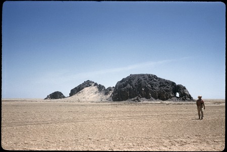
Located at the far north-east end of the Sierra Pinta, Howard Gulick photographs the window rock in 1959... note the man standing next to it for scale.


bb09227077_2.jpg - 158kB


Looking through the window:


[Edited on 2-26-2022 by David K]

David K - 7-29-2020 at 04:31 PM

On Google Earth: 31° 43.109'N, 115° 2.288'W
Access from the cell tower road, Km. 109, but don't drive onto the playa in case the tide has been high (and is hidden below the salt)!

[Edited on 7-29-2020 by David K]

PaulW - 7-29-2020 at 05:10 PM

I tried to get there from the north starting from the new bridge (k107). I was alone and the mud was very soft. I did not have the coords at that time an was driving from his description.
How did you get the coords?

David K - 7-29-2020 at 05:16 PM

Quote: Originally posted by PaulW  
I tried to get there from the north starting from the new bridge (k107). I was alone and the mud was very soft. I did not have the coords at that time an was driving from his description.
How did you get the coords?


I flew over it on Google Earth.

PaulW - 7-29-2020 at 05:22 PM

But how did you know which rock was the location.
Next year I will try to drive there. I just made two GE tracks to try. Starting just south of the tower road in a poorly defined gully. I wonder if there will be access thru the fence.

David K - 7-29-2020 at 05:37 PM

I knew where La Ventana was because Howard Gulick put it on his map. Then I simply flew over the area on Google Earth and matched the hill to the 1959 photo from Howard Gulick.

David K - 12-19-2020 at 10:27 AM

La Ventana came up in a Facebook post... this fellow saw weird globes over the delta in 1982.

https://www.facebook.com/groups/historiadelapeninsuladebajac...

mtgoat666 - 12-19-2020 at 10:39 AM

Quote: Originally posted by PaulW  
But how did you know which rock was the location.
Next year I will try to drive there. I just made two GE tracks to try. Starting just south of the tower road in a poorly defined gully. I wonder if there will be access thru the fence.


It’s only 1+ mile off the paved road. Easy walk. Every long drive is healthier for the body if you stop midway for a bit of exercise, 1-hr per day of exercise will improve health and lead to longer life.

PaulW - 12-19-2020 at 04:10 PM

I made a GE track to the place. 1.26 miles when driven
Exit Hwy5 at KM109

Attachment: to Ventana-1.kml (6kB)
This file has been downloaded 207 times

[Edited on 12-20-2020 by PaulW]

David K - 12-19-2020 at 04:16 PM

Nice job Paul.

PaulW - 12-19-2020 at 04:24 PM

Before I got Davids correct instructions I spent several days looking for Bruce Barber's ventana west of highway 5 and I found many small caves and one big window. Since we found this big one the Jeep club makes regular drive/hike to that place.


P3021888-150.jpg - 188kB P1090336.JPG - 80kB

David K - 12-19-2020 at 04:36 PM

Very cool... Yes, I was a fan of Bruce's writings/ book. Many 'ventanas' in that region!

I had hoped to get him and Choral Pepper connected because he was so fascinated with finding the Melchior Diaz Grave, after reading her Desert Magazine story, but she died before we could make it happen. I met Bruce at the Pyramid Resort event and he signed my copy of his book.

PaulW - 12-19-2020 at 05:22 PM

My mission with Bruce was a little confusing. Followed his directions and came up blank. Kept trying out west. Lots of hiking and driving so I was happy. Never once did he suggest to look east of the highway.
Similar to the Diaz directions he gave me. More driving and hiking with no success
I do think Bruce and buddy did incomplete research and did a lot of guessing for his searches.
Anyway it is a lot of fun wandering around in the backcountry.

David K - 3-24-2021 at 10:37 AM

Quote: Originally posted by PaulW  
My mission with Bruce was a little confusing. Followed his directions and came up blank. Kept trying out west. Lots of hiking and driving so I was happy. Never once did he suggest to look east of the highway.
Similar to the Diaz directions he gave me. More driving and hiking with no success
I do think Bruce and buddy did incomplete research and did a lot of guessing for his searches.
Anyway it is a lot of fun wandering around in the backcountry.


There is renewed interest in retracing Walter Henderson's search. Since his directions use La Ventana, it is important to know the La Ventana of the 1930s was this window rock along the old dirt road to San Felipe and not the closed gas station and store location on the paved road.

Bruce Barber and others following what Choral Pepper wrote all had an incorrect starting point for figuring where the hike began. La Ventana was a waypoint and not the starting point, which was 20 more miles south and then west at the base of the mountains.

David K - 4-6-2021 at 02:00 PM

Bump for Paul

PaulW - 4-6-2021 at 02:08 PM

Thanks