BajaNomad

Solo travel? Loreto to Cataviña

CiriosGal - 11-8-2020 at 02:59 PM

What are the biggest safety risks for a solo female traveler? I'm considering a 5-8 day trip in March/April. Flying into Loreto, renting a car and exploring the deserts up to Cataviña; Sierra de la Gigante, Sierra San Francisco and the Valle de los Cirios. I'm a field-biologist from Idaho. Hoping to combine some camping with hotel stays; some eating out with camp food/local groceries. No spanish skills. No adventure partner to bring along. I do have experience with solo international travel, but never before off the beaten path.

I visited Baja (drove ~600mi down from Tecate) for a week+ back in 2012 and although I was super nervous, never had trouble with the army checkpoints or Pemex and never got robbed or harassed. Even helped some teenage kids get their car unstuck one night from the beach. Fascinating, desolate place!

StuckSucks - 11-8-2020 at 03:35 PM

I am not a female, so probably not qualified to answer your question.

But, as a guy, I have driven the length of the peninsula solo several times, plus a bunch of times to intermediate spots, and have never felt threatened. Actually, when I'm remote, I tend to feel more relaxed than on the north side of the border.

Be aware of your surroundings, and it sounds like you'll have a killer trip.

David K - 11-8-2020 at 04:16 PM

Plenty of lady Nomads who drive without fear, Paulina is maybe the most well-known.

However, like Stuck, I drove over 12,000 miles solo in 2017 mostly camping in the boonies or isolated beaches. No issues other than missing my wife! I was on a series of working trips for a future road guide and map.

It is helpful that you have been down to Baja before. You should be fine. Have a great trip. Feel free to utilize my site and it's links for trip planning: www.vivabaja.com

AKgringo - 11-8-2020 at 04:31 PM

That time of year, the difference in temperature from sea level to the mountains can be drastic at night! Bring warm cloths and sleeping bag, and be prepared to sweat a lot during the day.

Whale-ista - 11-8-2020 at 06:28 PM

Welcome CiriosGal!
Spring is a wonderful time to visit Baja.

I've been a solo Baja traveller for many years, and lived in Ensenada before that. I have also travelled solo, and with other women, in various countries.

These photos are from an all-woman Baja trip I organized few years ago. We enjoyed a delicious dinner in the town of San Ignacio, following a few days of whale watching at the lagoon.


Based on my travel- I suggest you use the same common sense people employ anywhere in the world:
- Develop a travel plan and prepare/research accordingly
- Let friends/family know where you will be and when, and how they can contact you if needed (related: have a cell plan that will work in Baja)

As you travel from Loreto
- Develop friendly connections with people you meet as you travel: when you stop to eat or fill the gas tank, ask for advice on local sights, recommendations on places to stay, where to shop for groceries, etc.

- Tip people who provide service- even a small amount for food servers and gas station attendants (who will pump the gas and usually clean your windshield) will be appreciated.

- For camping: do so with others around and keep valuables out of view.

- At highway checkpoints (staffed by military): have all your valuables in one or two bags that you can carry with you if they ask you to exit the car to search inside. This is normal procedure- and they also appreciate a cold drink on warm days.

- If stopped for a traffic violation and asked to pay a fine, better to insist on driving to the nearest police station to settle any payments at the office vs. on the side of the road/highway.

As for exploring: There are native Mexicanos as well as people from all over the world living in Baja who can advise you on places to visit, guides to work with, places to stay etc.

You might want to check with Zihul Martinez in Guerrero Negro re:tours into remote areas around the central Baja area. (He's available on Facebook)
This is from a pronghorn sheep conservation program near the town:


If you are interested in whales in March: Shari Bondy is also in Gr. Negro and also knows many local guides/families to lead you into remote areas. This is her in action, taking photos. She's at www.whalemagictours.com


Hope this is helpful.

Feel free to send a message if you have any specific questions, and welcome to Baja/BajaNomad!


[Edited on 11-9-2020 by Whale-ista]

Lee - 11-8-2020 at 08:39 PM

Quote: Originally posted by CiriosGal  
What are the biggest safety risks for a solo female traveler?

No spanish skills.


Biggest risks being profiled/targeted. Carry a weapon. I prefer a knife.

No Spanish skills? Don't know the culture/language? You need at least conversational Spanish. Get a book and study.

TMW - 11-8-2020 at 09:05 PM

I would suggest you bring a communications device like a satellite phone. You can rent them from various places. The best use the Iridium satellite system. This way if you have any problems you can call for help or just call someone to talk. Cell phones work in the larger cities but not in the outback areas. Here are a couple of stores.

https://www.allroadsat.com

https://satellitephonestore.com


Cliffy - 11-8-2020 at 09:10 PM

If going off the pavement anywhere make sure you rent something 4 wheel drive. Carry basic survival stuff water sleeping bag buy a cheap shovel maybe a small axe to cut brush if bogged down in sand etc etc

Might give some thought to a SAT phone for the duration of your trip. AT the very least you can get a Garmin InReach GPS so friends can follow your travels on computer and you can send text messages any where you are. Also in case of a real bad deal (life threatening) you can summon emergency help with it 24/7

The people of Baja are some of the most friendly in the world. Its the other travelers I wonder about.

JZ - 11-8-2020 at 09:12 PM

Quote: Originally posted by Lee  


Biggest risks being profiled/targeted. Carry a weapon. I prefer a knife.


Jesus Lee. This is not true.

Don't do this.


[Edited on 11-10-2020 by JZ]

PaulW - 11-9-2020 at 05:49 AM

Most of us, like the guy responders above, drive 4x4 rigs and have communication devices. We are in touch with help as required.
I would think as a woman you would be well advised to stay away from isolated places. Traveling point to point mostly on the main roads would be low risk. Travel in the most isolated places is usually done with at least one other partner.
With a communication device like Sat phone or Inreach you must have a contact list of proven persons that can really provide assistance - not just chit chat. These contacts should be arranged by where they are located. It would not help to contact someone in San Diego when you are stuck in the sand near Chapala.
With my solo travels when in trouble I have never been able to reach any help and had to improvise. Scarry and it took more than a day to get back to the highway.
I doubt if a rental will come with self-recovery stuff like most of us carry. Like how can you get unstuck with a rental?
Like you said Baja is "Fascinating, desolate place!"

BajaMama - 11-9-2020 at 07:47 AM

I have driven that stretch alone many times (I'm 61 now). I prefer staying in hotels, not sure I would feel comfortable camping solo. I keep cash in 2-3 different places and only keep what I need for the day in my purse/wallet. I do keep a knife handy, and a very large mag light flash light within reach in my car. I used to keep wasp spray close but I seem to recall it is not legal?
I only keep the "weapons" because I am a smaller, older woman. I have never, ever had reason to even consider using them. I always bring ziplock bags of mini candy bars for the young men at the military check points. Remember to get out of your car to watch gas station. employees fill your tank.
If you are renting a car, make sure you stay on 2 WD roads, careful of recent washouts.
Overall, locals in Baja are wonderful but there is always the chance of a bad apple or two, so always be aware of your surroundings.
Mission Hotel is Catavina is nice and they have a restaurant. The yurts in San Ignacio are nice too. If you are there in March/April, you may want to toss in a whale watch trip either in San Ignacio or Guerrero Negro area.
Oh, your cell phone will not work unless you are close to a larger city (Loreto, Mulege, Vizcaino, Guerrero Negro, Santa Rosalia, San Ignacio) so a sat phone is a good idea if you need to keep touch.

[Edited on 11-9-2020 by BajaMama]

shari - 11-9-2020 at 12:04 PM

Myself, my daughter and lots of women friends drive and sola camp but there are places it is not advisable to camp. Talk to folks in each area. Dont tell people you are alone and if someone shows up tell them your husband will be back soon.
I suggest getting a Garmin In Reach so you can have communication in areas not on the grid and without cell service. It has contact numbers in it and you can send an SOS or text message to contact emergency numbers. If you want I can be one of your contacts as I live in Central Baja and know lots of people who can help in case of emergencies....just U2U me.

JZ - 11-9-2020 at 05:09 PM

Look at the cell coverage map for your service provider. Most of the way along the highway from Loreto to Guerrero Negro you will have good cell service. Above there to Catavina there won't be.

Here is the map for at&t: https://www.att.com/maps/wireless-coverage.html.


[Edited on 11-10-2020 by JZ]

ehall - 11-10-2020 at 02:25 PM

Post up when it gets closer. A lot of us enjoy camping trips and exploring.

azucena - 11-10-2020 at 05:29 PM

I have travelled solo to Baja since the 1980s sometimes with my children and sometimes alone .

I have never had any probem whatsoever, although I no longer pull off the road in random places to spend the night.

I carry a cell phone , but in much of the interior there is no service. I have never carried a Sat phone, but that is a good suggestion.

I also have never carried a weapon such as a knife, but do have a mag flashlight. Problem with things like knives they can easily be used against you by someone or someones stronger than you.

For me, my best "defense " has always been being watchful of my surroundings, being polite and friendly, and as someone else mentioned up thread, a few bags of candy can go a long way at checkpoints.
Speaking the language is an asset, and even if you make mistakes the effort is hugely appreciated.

People in Baja (and much of Latin America ) are courteous.
Every time you enter a store, resturaunt, gas station, anywhere, a Buenos Dias is HUGE
Years ago, I entered a small cafe in a rural area, at that time not accustomed to gringos, and every eye was on me and it felt a little tense. As soon as I spoke a Buenos Dias the entire atmosphere instantly changed.
Porfavor and gracias are also important.
When in a eatery saying Buen Provecho ( enjoy your meal ) to people eating around you is also a polite thing to do.

I remember getting a flat in an isolated area, and two locals pulled over, changed my tire and I had to insist they take the money I offered.

Baja has changed but the Cholleros , Baja natives are the generally the most honest, kind people you could ever meet.
But like anywhere, keeping your eyes and ears open and paying attention is your best way to be safe. If something feels not right, trust yourself.

KasloKid - 11-10-2020 at 05:30 PM

Quote: Originally posted by JZ  
Quote: Originally posted by Lee  


Biggest risks being profiled/targeted. Carry a weapon. I prefer a knife.


Jesus Lee. This is not true.

Don't do this.


[Edited on 11-10-2020 by JZ]


Right... knives with a blade length over 3 inches (I think the max is 3 or less) is a prohibited weapon in Mexico. Others may chime in with objections to this comment, but it is against the law... same as mace or bear spray.

Lots of good advice posted.

Common sense and situational awareness is the key to any potential scenario.

Lee - 11-10-2020 at 07:44 PM

Quote: Originally posted by JZ  
Quote: Originally posted by Lee  


Biggest risks being profiled/targeted. Carry a weapon. I prefer a knife.


Jesus Lee. This is not true.

Don't do this.


[Edited on 11-10-2020 by JZ]


There's a bigger risk than being profiled/targeted? What is it?

And, this is true for me. Not a problem. And, I don't really care what the law is in MX regarding a knife. Apologies to those who take offense.

thebajarunner - 11-11-2020 at 09:09 AM

Mostly good advice

Go out to Abreojos and check in with Blanca
She is right there at La Bocana
She can steer you to safe places
Go up to Asuncion, Shari can do likewise
LABay, go to Archelon and see Bety. She is like family and will make you feel right at home.

Bad advice....
Knife.... unless you are special weapons trained and have a black belt I advise you keep a small knife for whittling and fixing. Trying to defend yourself with a knife would not end up pretty

4 wheel drive.... oh boy, here we go again.
Nomad has a clique of folks that worship the concept of 4 x 4 vehicles. It is almost a small cult.
YOU DO NOT NEED FOUR WHEEL DRIVE TO GO OFF THE PAVEMENT!

How to safely navigate 99,8% of Baja roads with standard 2 wheel drive:
Don't drive across the sand dunes
Don't drive up a real sandy wash
Don't drive off into a muddy area
Don't try to climb a vertical hill studded with big rocks.
Don't listen to the 4 x gang!!

Have fun, if the going gets questionable off road just air down your tires, You will do fine.

pacificobob - 11-11-2020 at 09:34 AM

i have a female neighbor , 74yo, who drives the length of the baja twice a year. sola! she checks in with family and friends along the way,and takes the usual precautions. daylight driving ect.

wilderone - 11-11-2020 at 10:56 AM

I have traveled Baja alone many times. Most of my vehicles have been 2WD, but with a little clearance. Last trip - 16 days - I flew into Cabo and rented a standard 2WD sedan. Went offroad a lot - squirreled around in the sand a bit, bumped over some rocks, etc. - but always made it through. I never felt unsafe. If I get a "vibe" when scouting out a boondock camp site - I leave. Just relax - if a dirt road seems dicey because of sand or erosion ditches, walk it, maybe toss some large rocks, look for the most solid ground. Just relax and have fun. If you take a laptop, you can stay in touch with Bajanomad people for advice and contacts. As mentioned above, spend some time with Sherry in Asuncion, or Blanca at LaBocana.

bajaric - 11-11-2020 at 10:57 AM

Seems like those areas would be pretty safe. Best thing is to ask the locals to see what they think about staying in a particular area. Some areas are known for clandestine activities, mainly along certain stretches of coastline, on back roads that can be used to bypass the military check points, and remote areas with hidden water sources. Thus the safest areas are inland areas in the desert, away from transportation routes.

Personally, when I camp in remote areas I always try and find a side road that is out of sight of the main road, and pick a spot with two avenues of escape, so that in the highly unlikely event that some hostile persons show up in the middle of the night I can hop in the truck and bail without getting boxed in by another vehicle. Paranoia? Perhaps. I have never had an unpleasant incident when camping in remote areas, other than hearing a truck rumble by in the middle of the night, way out in the middle of nowhere....

Of course, I am a large male, so being female adds another dimension to it. And, by camping out of sight in remote areas you basically are completely on your own, no cell phone signal, no one around to render assistance in the unlikely event of some kind of trouble. I would think it better for a woman to stay in established paid camp grounds and go on day hikes for a little added security. Plenty of awesome day hikes in the areas you mentioned. The native flora and fauna in the Catavina area is outstanding, like a botanical garden, only created by nature.

Final tip, carry plenty of water, even on travel days. Getting lost, getting stuck, and running out of water can result in a highly undesirable outcome.

wilderone - 11-11-2020 at 11:30 AM

8 days is not very much time. Maybe not try to go as far as Catavina. If you go in mid-March, you'll get to do some whale watching near Guerrero Negro or San Ignacio. Whales would probably still be around late March around Bahia Magdalena.

David K - 11-11-2020 at 11:45 AM

Bahía de los Angeles is a shorter drive than Cataviña is and the desert vegetation is more spectacular (tallest boojum trees)... plus the amazing view of the bay and all the islands!

Aw come on David, don't let your LABay obsession get in the way

thebajarunner - 11-11-2020 at 05:25 PM

Quote: Originally posted by David K  
Bahía de los Angeles is a shorter drive than Cataviña is and the desert vegetation is more spectacular (tallest boojum trees)... plus the amazing view of the bay and all the islands!


From the junction it is 41 miles to LABay and 64 miles to Catavina
In the broad scope of "The Baja" 23 miles is hardly a ripple
And the cirio/boojum array in Catavina is best in the world
All the flora and granite in Catavina is world class
I agree LABay is worth the detour, just meeting Bety is worth the drive
But Catavina is just head and shoulders above the rest of the desert.
Of course, if the obsession is seeing blue water, than LAB is good
But the beaches are bleah and the town is also pretty bleah.

David K - 11-11-2020 at 05:53 PM

It is more of a boojum obsession with me! The L.A. Bay road and the San Borja side trip are off the charts for boojum beauty!
Cataviña has the boulders, and that makes it an impressive place!


Cancamo - 11-11-2020 at 06:12 PM

Rental car insurance usually does not cover damage when driven off the pavement. Read the fine print.

bajarich - 11-11-2020 at 11:14 PM

Stay off loose sand unless you have a way of extricating yourself. I have helped push or pull a lot of rental cars out of the sand. You need to be able to air your tires down and re-inflate them.

It also voids if you have a cerveza

thebajarunner - 11-12-2020 at 09:11 AM

Quote: Originally posted by Cancamo  
Rental car insurance usually does not cover damage when driven off the pavement. Read the fine print.


Take "The Road Less Traveled" and enjoy
You will be just fine
Note, several of us mentioned sand
You will generally encounter it only close to the beach and in sandy washes

Whale-ista - 11-12-2020 at 05:24 PM

Good evening CiriosGirl-

Please let us know if these answers are helpful, or if you are seeking different/additional information.

Skipjack Joe - 11-12-2020 at 09:28 PM

Your biggest danger is contracting the virus on the flight to Loreto. Or back.

mtgoat666 - 11-12-2020 at 09:58 PM

Quote: Originally posted by CiriosGal  
What are the biggest safety risks for a solo female traveler?


#1 risk: covid.


Lengua - 11-13-2020 at 09:04 PM

Be Prepared , Sat phone ,Garmin In reach device and if by chance you need to defend yourself - bring what you need...

FYI , Highly unlikely you'll have any issues......

AKgringo - 11-14-2020 at 08:27 AM

Six days since posting, and 33 replies so far, but the original poster appears to be a "one and done" newbie!

Mother of Dragons - 11-14-2020 at 08:44 AM

I have driven solo several times through different parts of Baja and I’m a woman and have never been worried or had any run ins.

Just use common sense and you may run into another solo female/ or people along the way and caravan with them between towns.

U2U me if you have any questions on driving alone as a woman.

Carrying bear mace

eguillermo - 11-14-2020 at 07:32 PM

I've had a can of bear mace stowed deep in a box on every one of ten or so trips down as far as Insurgentes.

Common sense suggested that if the checkpoint guys found it, I'd have to give it up/pay a fine. My prepared statement was "It's for lobos or coyotes that come into camp." Which actually does happen in some of the places I camp.

In reality, I bring it inside the tent when I'm remote and alone. My brightest light and a blast of that would be first means of defense in a bad situation. After that, the best I got is aluminum fly rod cases to swing :)

All that said, in my ten or so trips I've camped out alone on dirt roads or islands in the Cortez for what is easily over 100 nights and have not had the slightest issue.

JZ - 11-14-2020 at 07:50 PM

Quote: Originally posted by Lengua  
Be Prepared , Sat phone ,Garmin In reach device and if by chance you need to defend yourself - bring what you need...

FYI , Highly unlikely you'll have any issues......


I've traveled with a sat phone, and have an InReach Mini.

We only do this because we go out in the middle of nowhere, with no one around. Especially, when we go on long, multi-day trips on the boat we take a sat phone.

I don't think someone sticking close to the highway needs either.

Don't bring weapons.

Lee - 11-14-2020 at 09:44 PM

Quote: Originally posted by JZ  

Don't bring weapons.


Naive. Out of touch. Lulled into a false sense of security.

mtgoat666 - 11-14-2020 at 11:16 PM

Quote: Originally posted by Lee  
Quote: Originally posted by JZ  

Don't bring weapons.


Naive. Out of touch. Lulled into a false sense of security.


What weapon are you carrying?

CiriosGal - 11-15-2020 at 03:24 AM

I'm a little overwhelmed by the amount of activity here. What a cool forum! Especially glad for those of you who shared candid travel advice, photos and names of folks who I might reach out to.
Not a one and done newbie 😝

Should I decide for certain to make the trip, it will not be for another 4 ½ months. Hopefully there will be fewer daily covid cases than we're seeing nowadays. I'm going to wait a few more weeks before booking so I can let the cost and idea of soloing sink in a little more.

I've ordered "Hiking Loreto"... Also spent some time studying Google Earth. Sounds like travel in Baja is no more dangerous than driving/ camping alone in *middle of nowhere* Arizona, Nevada or Utah.

Also, I'm good with the driving risks.. I've driven a lot of roads for work and play here in the states. 2wd, SUVs and 4x4s on sand, large rocks, bedrock, sidewall hazards. A few good memories of getting stuck (or tearing off the muffler in a civic 🤭)..My biggest fear is encountering a group of people out in the desert who either don't want a tourist around or didn't want to be found.

You can find a catalogue of some of my past travels here: www.flickr.com/photos/walksonrocks/albums
.

[Edited on 11-15-2020 by CiriosGal]

BajaNomad - 11-15-2020 at 10:34 AM

Quote: Originally posted by Lee  
Quote: Originally posted by JZ  

Don't bring weapons.


Naive. Out of touch. Lulled into a false sense of security.


Firstly, guns - and as noted, knives, bear mace, etc - are illegal. She said she's flying in too Lee. Even if you're driving, you risk jail time if/when caught.

Not good luggage for a plane, but baseball bats and machetes (viewed as farm equipment) have been mentioned by members here in the past as something they bring for road trips.

YMMV

wilderone - 11-15-2020 at 10:35 AM

"My biggest fear is encountering a group of people out in the desert"
Highly unlikely. Occasionally when I have ventured offroad, and found myself at the end of day looking for a place to boondock camp, I have inadvertently ended up on someone's property. Sometimes they will drive by on they way to their ranch (or once, by horseback doing his perimeter check), visit a bit, and welcome me to stay. A couple times, said they'd come by in the morning and check on me. I have never had a negative experience at a camp site, I think because I remote camp with nobody around.
The first day on the road you'll be on high alert, but the next day, be much more relaxed (I would assume you'd be in the Gigantas on Day 2 having visited Mision San Javier?) Lots of places to boondock camp around there - classic Baja California landscape - or even ask for permission to camp on someone's ranch - that's a special experience in itself.

Weapons?

Howard - 11-15-2020 at 10:38 AM

It seems like you are equipped with the most important thing for Baja travel (or for almost anywhere for that matter, "common sense and awareness."

The suggestion that you should carry a weapon is absolutely absurd. Now if you were trained or are very familiar with that weapon, maybe and that is a big maybe. I am talking about bringing a manchette, baseball bat or small knife but never a gun. Without the killer instinct or defense training they could be used on you as easily as you trying to defend yourself.

Springtime is a lovely time to travel so come on down when you feel most comfortable.
Have you started you list of things to bring?
1: Water, at least a spare gallon over and above you daily water.
2: Basic first aid kit
3: Swiss Army Knife or comparable tool
4: Garmin In Reach or comparable, use it on all your other trips as well
5: Good spare and folding shovel
6: It can get cold in elevation, so something warm
7: Tequila (Maybe should be #1 on the list)
8: Health snacks
9: Music
10: If you have the space, binoculars

I am sure the rest of this Forum will add items.

Have fun!

Howard - 11-15-2020 at 10:44 AM

Oops, she is flying


Maybe I'll read next time.

Most of those items can be purchased down here. If I happen to be down here then I can loan you a lot of the stuff.

I will U2U you with my contact information.

Lee - 11-15-2020 at 12:05 PM

Quote: Originally posted by BajaNomad  

Firstly, guns - and as noted, knives, bear mace, etc - are illegal. She said she's flying in too Lee. Even if you're driving, you risk jail time if/when caught.


Right, flying is a different game.

Anyone worried about arrest for an illegal weapon in Baja should travel unarmed.

Grey areas abound. Spear guns, flare guns, a baton that looks like a stick.

Not interested in debating the merits of what's legal and what's not in Mexico.

Napoleonic law is law of the land in Baja. You're on your own and police are no help. Draw your own conclusions. Just don't peddle false information about personal safety.

Whatever.

pacificobob - 11-16-2020 at 10:00 AM

Quote: Originally posted by Lee  
Quote: Originally posted by JZ  

Don't bring weapons.


Naive. Out of touch. Lulled into a false sense of security.


in the 70s i was living in Central America. some cities were a bit sketchy to walk about late at night......for whatever reason, i was occasionally doing some of that.
although the carrying of weapons was frowned upon by the police,i found a workaround. when a new machete or banana knife is purchased, the clerk often took a single piece of newspaper, wrapped and taped it on the blade. to the cops i looked like a fellow who had been shopping. to others, like a less likely victim.
did it for years, never a problem. if i were a thug, i would wait for an easier target.

wilderone - 11-16-2020 at 11:27 AM

Here's another story. I was camping on the outskirts of a small town on the Yucatan peninsula. I found an old quarry, about 100 yards off the main street into town - apparently not much used. At dusk, I set up my tent, settled in for the night. About an hour later, in the dark, a large truck pulled up fast and stopped. Oh chit, I thought, I'm going to be robbed. Two car doors slammed, and "policia" shouted at me. If it were a robbery (or worse), do you think I had time to find a weapon, unzip my tent, and defend myself against two men? Same thing with a weapon tucked out of sight - you're a fool if you think you'd be in a physical position to quickly arm yourself with the relied-upon weapon - wherever it was - in a dicey situation. BTW, the policia told me it was not advisable to camp there and that I should get a hotel room in Izamal, which I did, and was able to experience a lively Carnival event.

Lee - 11-16-2020 at 02:20 PM

Quote: Originally posted by wilderone  
If it were a robbery (or worse), do you think I had time to find a weapon, unzip my tent, and defend myself against two men? Same thing with a weapon tucked out of sight - you're a fool if you think you'd be in a physical position to quickly arm yourself with the relied-upon weapon - wherever it was - in a dicey situation.


Lame excuse for being unable to defend yourself. You were in a vulnerable position and defenseless because you didn't know where your gear was.

Hope you have learned from past experiences and mistakes (not knowing you were at risk camping in the spot you chose, and not knowing where your gear was) but it doesn't sound like it.

Tell us you've learned from these past mistakes when in Baja?


David K - 11-16-2020 at 06:13 PM

Let Nomads tell their story in peace... only bug them if they spell a town incorrectly, LOL!

Thanks Cindi for sharing!

CiriosGal - 11-16-2020 at 07:52 PM

Quote: Originally posted by Lee  
Quote: Originally posted by wilderone  
If it were a robbery (or worse), do you think I had time to find a weapon, unzip my tent, and defend myself against two men? Same thing with a weapon tucked out of sight - you're a fool if you think you'd be in a physical position to quickly arm yourself with the relied-upon weapon - wherever it was - in a dicey situation.


Lame excuse for being unable to defend yourself. You were in a vulnerable position and defenseless because you didn't know where your gear was.

Hope you have learned from past experiences and mistakes (not knowing you were at risk camping in the spot you chose, and not knowing where your gear was) but it doesn't sound like it.

Tell us you've learned from these past mistakes when in Baja?


Lee, I kinda expected more people to echo your perspective to my original question. I appreciate your advice.

However, since I'm the OP on this thread, I will decide who's advice or story is "lame".

Semper Fi

CiriosGal - 11-16-2020 at 07:59 PM

I'm just now figuring out that the US-Mexico land border is open both directions for American citizens; is this true?

Gaww "closed". Reentry for gringos is deemed "essential travel".

JZ - 11-16-2020 at 08:02 PM

Quote: Originally posted by CiriosGal  
I'm just now figuring out that the US-Mexico land border is open both directions for American citizens; is this true?

Gaww "closed". Reentry for gringos is deemed "essential travel".


No restrictions on air travel. Mexico wants tourists to come.

Supposed to be a restriction for driving, but neither side is enforcing it.

By Spring things should be even more wide open.


JZ - 11-16-2020 at 08:13 PM

Agua Verde is a really, really fun day trip from Loreto. Its a dirt road a few miles after the turn off, but easy for a 2 wheel drive. There is a small community there and you can camp safely.

Just ask and we can give you a ton of suggestions.


mtgoat666 - 11-16-2020 at 08:33 PM

Quote: Originally posted by CiriosGal  
I'm just now figuring out that the US-Mexico land border is open both directions for American citizens; is this true?

Gaww "closed". Reentry for gringos is deemed "essential travel".


Trumpets are traveling because they ignore the public health advisories to stay at home, avoid travel. Ya, it’s open, if you like traveling with anti-mask, covid deniers and those who thinks the disease is a nothing burger...

If everyone did their part, the disease would be under control by now. But too many people are tired of the inconvenience of prioritizing grandma Before their hedonistic needs.


del mar - 11-16-2020 at 08:38 PM

Quote: Originally posted by mtgoat666  
Quote: Originally posted by CiriosGal  
I'm just now figuring out that the US-Mexico land border is open both directions for American citizens; is this true?

Gaww "closed". Reentry for gringos is deemed "essential travel".


Trumpets are traveling because they ignore the public health advisories to stay at home, avoid travel. Ya, it’s open, if you like traveling with anti-mask, covid deniers and those who thinks the disease is a nothing burger...

If everyone did their part, the disease would be under control by now. But too many people are tired of the inconvenience of prioritizing grandma Before their hedonistic needs.


tell us again how your vacation travels were different?

mtgoat666 - 11-16-2020 at 08:40 PM

Quote: Originally posted by JZ  


Supposed to be a restriction for driving, but neither side is enforcing it.


Usa is enforcing it. Most Mexicans cannot enter the USA. Friends in TJ and Ensenada have not been able to cross since last spring...


JZ - 11-16-2020 at 08:43 PM

Quote: Originally posted by mtgoat666  


Trumpets are traveling because they ignore the public health advisories to stay at home, avoid travel. Ya, it’s open, if you like traveling with anti-mask, covid deniers and those who thinks the disease is a nothing burger...


Ignore our forum clown. I've been all over the Southwest and Northwest since April. Just got back from my third trip to Nevada.

99% of ppl are willingly wearing masks and distancing when they travel. Ppl on both sides of the isle.

Yeah kids, again, from both sides, aren't as careful.


[Edited on 11-17-2020 by JZ]

surabi - 11-16-2020 at 09:13 PM

Quote: Originally posted by JZ  
Quote: Originally posted by mtgoat666  


Trumpets are traveling because they ignore the public health advisories to stay at home, avoid travel. Ya, it’s open, if you like traveling with anti-mask, covid deniers and those who thinks the disease is a nothing burger...


Ignore our forum clown. I've been all over the Southwest and Northwest since April. Just got back from my third trip to Nevada.

99% of ppl are willingly wearing masks and distancing when they travel. Ppl on both sides of the isle.

Yeah kids, again, from both sides, aren't as careful.


[Edited on 11-17-2020 by JZ]


You really don't get it.

It's like putting together a great meal- you don't just do that with one ingredient.

Masking, social distancing, limiting one's socializing to a small bubble, and restricting one's movements to all but essential outings are all essential parts of a whole which will curtail the spread of the virus. You don't just get to pick and choose which parts are acceptable to you and call that being responsible.

That's like a kid doing their English and Social Studies homework because they don't mind those subjects, but deciding never to do their Science and Math homework because they aren't interested in those subjects.


JZ - 11-16-2020 at 09:26 PM

Quote: Originally posted by surabi  


You really don't get it.

It's like putting together a great meal- you don't just do that with one ingredient.

Masking, social distancing, limiting one's socializing to a small bubble, and restricting one's movements to all but essential outings are all essential parts of a whole which will curtail the spread of the virus. You don't just get to pick and choose which parts are acceptable to you and call that being responsible.

That's like a kid doing their English and Social Studies homework because they don't mind those subjects, but deciding never to do their Science and Math homework because they aren't interested in those subjects.


Follow the science. The WHO tells us that lock downs after the initial outbreak + time for medical personnel to ramp up do more harm than good. Especially, in poor countries.

And few, if any, local govt.'s in US/MX have a policy enacting this right now: "....restricting one's movements to all but essential outings."

Also, you are a grown man who rents out a room at your house on a per day basis to strangers and shares a kitchen with them. Why on Earth would someone take advice from a person who has failed at life so badly that they need to do this?

Please stop trying to ruin this thread and move on if you have nothing positive to contribute.


[Edited on 11-17-2020 by JZ]

mtgoat666 - 11-16-2020 at 09:40 PM

Quote: Originally posted by JZ  
Quote: Originally posted by surabi  


You really don't get it.

It's like putting together a great meal- you don't just do that with one ingredient.

Masking, social distancing, limiting one's socializing to a small bubble, and restricting one's movements to all but essential outings are all essential parts of a whole which will curtail the spread of the virus. You don't just get to pick and choose which parts are acceptable to you and call that being responsible.

That's like a kid doing their English and Social Studies homework because they don't mind those subjects, but deciding never to do their Science and Math homework because they aren't interested in those subjects.


Follow the science. The WHO tells us that lock downs after the initial outbreak do more harm than good. Especially, in poor countries.

Also, you are a grown man who rents out a room at your house on a per day basis to strangers and shares a kitchen with them. Why on Earth would someone take advice from a person who has failed at life so badly that they need to do this?

Please stop trying to ruin this thread and move on if you have nothing positive to contribute.


[Edited on 11-17-2020 by JZ]


Why on earth would anyone take advice from shorty mcjizzy with raging Napoleon complex?


surabi - 11-16-2020 at 11:18 PM

Quote: Originally posted by JZ  


Also, you are a grown man who rents out a room at your house on a per day basis to strangers and shares a kitchen with them. Why on Earth would someone take advice from a person who has failed at life so badly that they need to do this?
[Edited on 11-17-2020 by JZ]


What a presumptuous jerk you are.

First of all, I'm not a man.

Secondly, I don't "rent out a room on a per day basis". It's not a flop house. I have a vacation rental- a private room/private bath with a private entrance and use of my kitchen. For people who want to come on vacation to a beach town and they stay for a week- 2 weeks. I have pages full of 5* reviews.
In case you're not aware, there are tons of home-share listings all over the world on Airbnb.

Thirdly, I don't "need to do this". I do it because I enjoy it- I have met amazing people from all over the world, some of whom have become friends I stay in touch with. Just like others who own B&Bs.

Lastly, I guess you call having raised 3 daughters who all grew up to be responsible, successful adults, owed a home in Canada that I renovated over the course of the 20 years I lived there and sold for a $200,000 profit, bought a lot and built a nice home with a huge garden in Mexico where I run an extremely successful upholstery business, "failed at life".

Have any other idiotic things to post?


JZ - 11-16-2020 at 11:35 PM

Quote: Originally posted by surabi  


What a presumptuous jerk you are.

First of all, I'm not a man.

Secondly, I don't "rent out a room on a per day basis". It's not a flop house. I have a vacation rental- a private room/private bath with a private entrance and use of my kitchen. For people who want to come on vacation to a beach town and they stay for a week- 2 weeks. I have pages full of 5* reviews.
In case you're not aware, there are tons of home-share listings all over the world on Airbnb.

Thirdly, I don't "need to do this". I do it because I enjoy it- I have met amazing people from all over the world, some of whom have become friends I stay in touch with. Just like others who own B&Bs.

Lastly, I guess you call having raised 3 daughters who all grew up to be responsible, successful adults, owed a home in Canada that I renovated over the course of the 20 years I lived there and sold for a $200,000 profit, bought a lot and built a nice home with a huge garden in Mexico where I run an extremely successful upholstery business, "failed at life".

Have any other idiotic things to post?


I'll hold off on any more back and forth.

Remember, you came at me. In a thread about helping someone out. You choose sides with Goat, the nastiest poster in the history of this board.


[Edited on 11-17-2020 by JZ]

CiriosGal - 11-17-2020 at 12:22 AM

Quote: Originally posted by JZ  
Agua Verde is a really, really fun day trip from Loreto. Its a dirt road a few miles after the turn off, but easy for a 2 wheel drive. There is a small community there and you can camp safely.

Just ask and we can give you a ton of suggestions.


I spotted that road! It also looked like there were some fantastic cliffs and rock formations between Agua Verde and the golf resort to the north.

One thing I really would like to do in the Loreto area is hike through a great non-technical slot canyon. Maybe some wading, scrambling. Tropical version of Zion NP. Someone mentioned San Javier as well and I want use the drive over to the mission to try a higher elevation hike. Not many trails though. I love to travel off-trail but not in thorn bushes. Weird spiders, bugs... Read somewhere there's a tree with toxic foliage like poison ivy.

David K - 11-17-2020 at 07:30 AM

Just west of Puerto Escondido is Tabor Canyon, fits your list pretty well! I have not hiked it but an Internet search should be good.

Here are just a few:

https://www.alltrails.com/trail/mexico/baja-california-sur/t...

https://www.discoverbaja.com/2018/03/03/puerto-escondido-tab...

https://www.tripadvisor.com/ShowUserReviews-g150772-d3151161...

https://www.marinapuertoescondido.com/hiking.php

wilderone - 11-17-2020 at 10:49 AM

"drive over to the mission to try a higher elevation hike. Not many trails though"
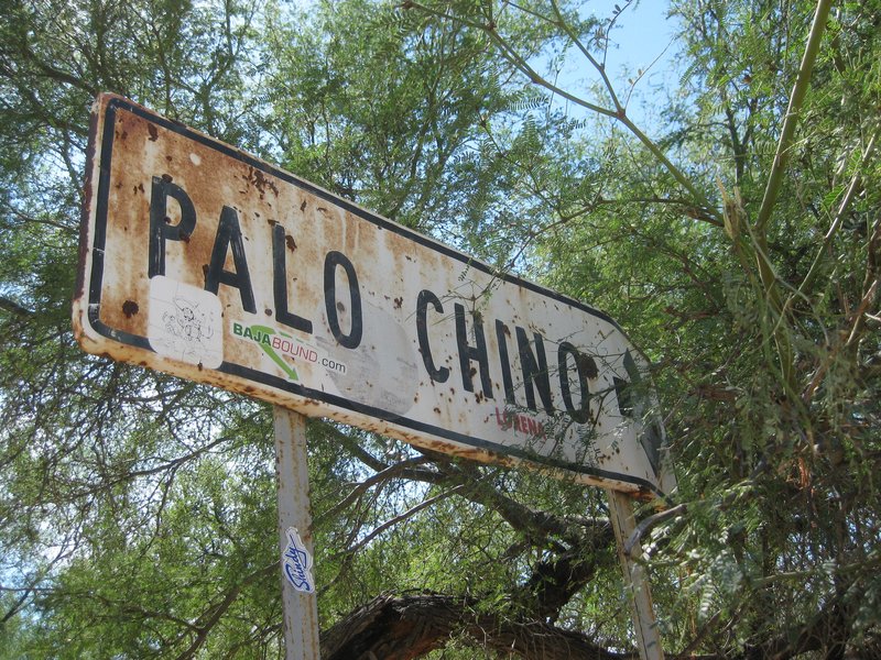
You'll see a fork in the road (Loreto to San Javier mission) that goes west to the Comondus. About 8-9 miles in, you see a sign for a rancho (last time I was there it was abandoned), for Palo Chino. You'll see a trail across the street from there - it goes for miles - 20? - until it hooks up again into the main road. Anyway, the people at the Palo Chino rancho would take people to an indigenous rock art site. Never went because we didn't have time, but on another trip, tried to find them. We discovered a habitation site, and eventually camped alongside the old El Camino Real. Thing is, there are many miles of old one-track, little used roads with old indian and mission trails here and there where you can bushwack all you want. If you get a Baja Almanac (Sur) map book, you can see all the dotted lines, which are dirt tracks but serve as hiking trails.
David: Can you show her that road with the trail from Palo Chino to Batequito?

David K - 11-17-2020 at 11:43 AM

Quote: Originally posted by wilderone  
"drive over to the mission to try a higher elevation hike. Not many trails though"
You'll see a fork in the road (Loreto to San Javier mission) that goes west to the Comondus. About 8-9 miles in, you see a sign for a rancho (last time I was there it was abandoned), for Palo Chino. You'll see a trail across the street from there - it goes for miles - 20? - until it hooks up again into the main road. Anyway, the people at the Palo Chino rancho would take people to an indigenous rock art site. Never went because we didn't have time, but on another trip, tried to find them. We discovered a habitation site, and eventually camped alongside the old El Camino Real. Thing is, there are many miles of old one-track, little used roads with old indian and mission trails here and there where you can bushwack all you want. If you get a Baja Almanac (Sur) map book, you can see all the dotted lines, which are dirt tracks but serve as hiking trails.
David: Can you show her that road with the trail from Palo Chino to Batequito?


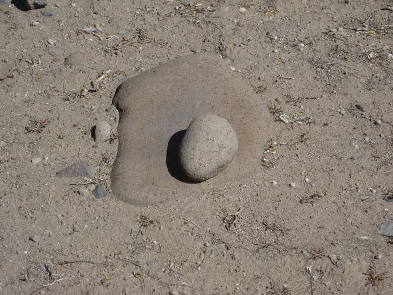
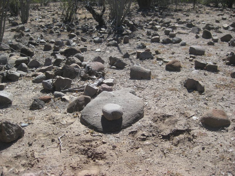
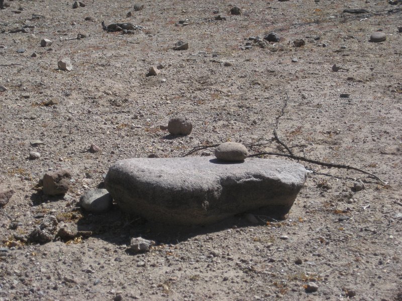
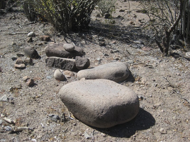
In 2017, Mike showed me the "kitchen" place you guys found. It was very cool. I heard that the metates were all removed since then (rancher or INAH?). Palo Chino was abandoned, just a sign.

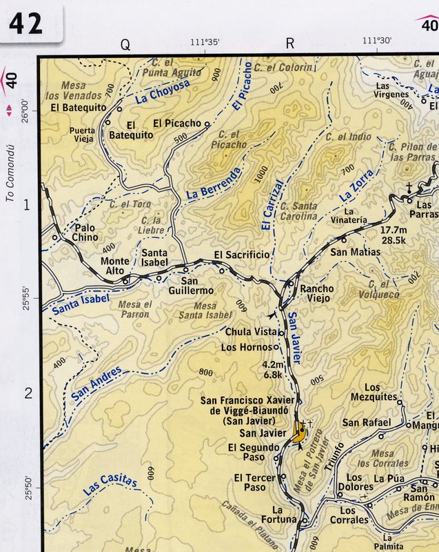
Here is a close up of the 2003 Baja Almanac showing Palo Chino and the trail to El Batequito...


More detailed map, zoomed in on Palo Chino: https://caltopo.com/map.html#ll=25.95633,-111.65049&z=15...


[Edited on 11-17-2020 by David K]

wilderone - 11-17-2020 at 12:30 PM

"metates were all removed since then (rancher or INAH")
Whaaaaa? WTF they'd been there for 100 years

David K - 11-17-2020 at 12:52 PM

Quote: Originally posted by wilderone  
"metates were all removed since then (rancher or INAH")
Whaaaaa? WTF they'd been there for 100 years


Maybe longer since those 'evil' ( :rolleyes: ) padres killed most all the Indians by the early 1800s!
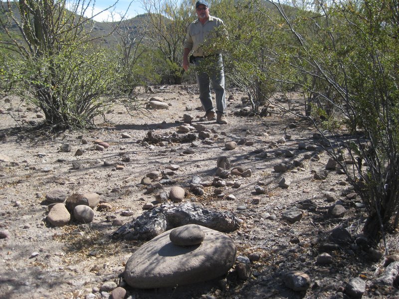
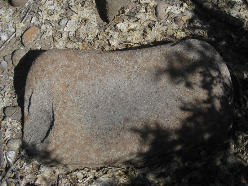

Photos may serve as a historic documentation of what this "kitchen" area had. The site was well hidden and not even visible from the foot trail some distance away from the dirt road.

Here are the metates in February 2017:


Mike Younghusband


JZ - 11-17-2020 at 07:18 PM

Quote: Originally posted by CiriosGal  


I spotted that road! It also looked like there were some fantastic cliffs and rock formations between Agua Verde and the golf resort to the north.

One thing I really would like to do in the Loreto area is hike through a great non-technical slot canyon. Maybe some wading, scrambling. Tropical version of Zion NP. Someone mentioned San Javier as well and I want use the drive over to the mission to try a higher elevation hike. Not many trails though. I love to travel off-trail but not in thorn bushes. Weird spiders, bugs... Read somewhere there's a tree with toxic foliage like poison ivy.


This could be a fun hike around Agua Verde. The path at the top is the road into AV.

There is a "back door" road out of AV that starts at "Exit from wash." For the last 3-4 years it has been impassable by 4x4 from storms washing out the trail with lots of rocks. We rode our dirt bikes up it a couple years ago, so it can definitely be hiked.

Steep, but not too steep to walk it. Once you get up a ways you can see the ocean.

I (and others) have tracks for all these places you can load into Google Earth or a phone app like Gaia.


[Edited on 11-18-2020 by JZ]

CiriosGal - 11-18-2020 at 02:28 AM

Wilderone, JZ, David. Interesting info, thanks. Question for anyone; Would you say the 2003 baja almanac is still the best map resource? There others more up to date? I know very well how maps depicting the type or quality of a road can be deceiving.

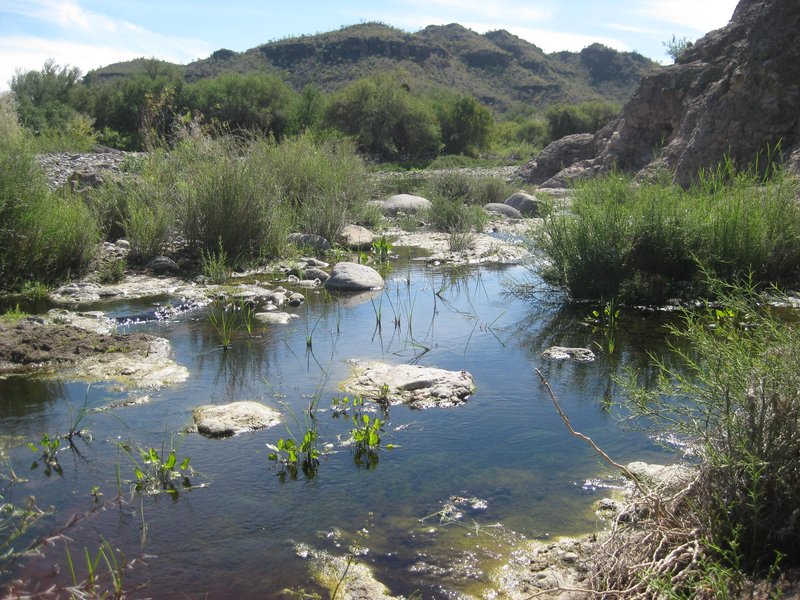
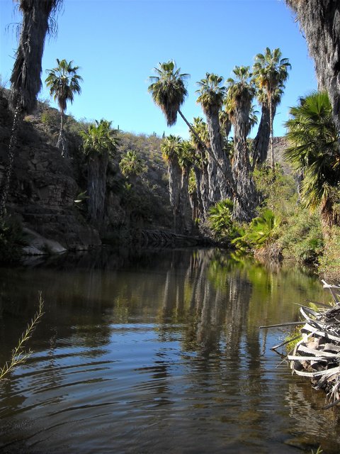
Also, where was that photo of the wetland taken? Is it a stream? Spring? Tank? Is the water drinkable if I were to use a katadyn type backpacker filter? I know for example that some springs in utah contain high levels of heavy metals or even radiation...I'm planning to carry all my water for the coming trip, but curious all the same.

Tabor canyon and others... Frustrating because I don't have a map with named washes, canyons etc and the internets doesn't seem to know either. =)

[Edited on 11-18-2020 by CiriosGal]

wilderone - 11-18-2020 at 08:39 AM

There are few, if any, comparable map books like the Baja Almanac which is out of print now. Map symbols, the little blue lines for streams, more likely dry washes. You will learn that roads in Baja - duly depicted on a map - can have deep sand, eroded ditches, mud, a boulder-strewn crossing, possibly all created during the last storm. The "quality" is also a relative term dependent on the type of vehicle you're driving (piece of cake for a Land Rover, not so much a Camry). You just need to be prepared, take it as it comes, have a Plan B. Rural Baja hasn’t changed much in 20 years. Yes, a backpacker water filter will be fine for most bodies of water in Baja. There are exceptions - the water found in the pools at El Volcan (near El Marmol - you might like to explore around this onyx mine), is undrinkable - too mineralized. That photo of a stream is running (more or less) at Palo Chino - I've pumped water out of there.


Around Monte Alto (see map above) you'll see a stream on the map called Santa Isabel. From the road you can see a lot of palm trees (El Palmarito). That's an interesting area, with an old adobe habitation site, ranchos, pools of water (S/SW).


JZ - 11-18-2020 at 08:56 AM

Quote: Originally posted by wilderone  
There are few, if any, comparable map books like the Baja Almanac which is out of print now. Map symbols, the little blue lines for streams, more likely dry washes. You will learn that roads in Baja - duly depicted on a map - can have deep sand, eroded ditches, mud, a boulder-strewn crossing, possibly all created during the last storm. The "quality" is also a relative term dependent on the type of vehicle you're driving (piece of cake for a Land Rover, not so much a Camry). You just need to be prepared, take it as it comes, have a


Most roads that get damaged by a storm get fixed in short order as they are traveled frequently by the ranchers.

Road conditions can always be checked on the forum.

David K - 11-18-2020 at 10:02 AM

The 2003 Almanac had the most detail (larger scale) and was in color, compared to the 1998 2-book Almanac.

The 2009 Almanac (the last one) went big (smaller scale maps) but had road updates, etc.

The 2010 AAA Baja Map (the last one) was very handy for planning and main road travel.

In 2021, there will be a new map book...

Until then, use CalTopo.com (link below or on www.VivaBaja.com ) for topo maps and satellite images... You can flip between various maps and see a combined satellite/ topo map. You can zoom in on any place for detail.

This online map is thanks to Nomad 'geoffff' (opens on the center of Baja, just scroll out and use your mouse to move about). The menu bar has preset layers of the various map choices: https://caltopo.com/map.html#ll=27.60902,-112.90375&z=11...

[Edited on 11-18-2020 by David K]

wilderone - 11-18-2020 at 10:19 AM

In all practicality, you'll probably be fine with a AAA map (only a week, and you can see from this message string, an idea of what to expect). Current conditions, boots on the ground, will dictate your choices. If you'd like me to send you a few pertinent pages from the Baja Almanac, I'm happy to do so.

Whale-ista - 11-18-2020 at 10:48 AM

FYI- Per my local AAA office: their Baja map is no longer available.
(I tried to get one earlier this month.)

I'm curious if anyone has used this National Geographic map? I found this one for Baja (North) at the Adventure 16 final sale earlier this year but I haven't travelled with it yet.


Don Pisto - 11-18-2020 at 11:08 AM

Quote: Originally posted by Whale-ista  
FYI- Per my local AAA office: their Baja map is no longer available.
(I tried to get one earlier this month.)

I'm curious if anyone has used this National Geographic map? I found this one for Baja (North) at the Adventure 16 final sale earlier this year but I haven't travelled with it yet.


I have the set they're beautiful maps but don't tell you much, maybe take Davids maps and add distances etc?

wilderone - 11-18-2020 at 11:13 AM

True, AAA no longer has a Baja map. However, you can still find them to buy. Here's a nice deal on eBay right now: Total $15 (with shipping) for 10 maps, including Utah, Nevada, Western States, Baja, California. I have them all and have been invaluable.

https://www.ebay.com/itm/10-Vintage-AAA-Western-States-Maps-...

motoged - 11-18-2020 at 11:44 AM

Quote: Originally posted by JZ  
Quote: Originally posted by surabi  


What a presumptuous jerk you are.


You choose sides with Goat, the nastiest poster in the history of this board.

[Edited on 11-17-2020 by JZ]


Surabi has it figured out, Jizz,

What category do you qualify for with your snotty and arrogant comments directed at Nomads who don't bow down to your pseudo-omniscience ?

Just curious :?:

bajaric - 11-18-2020 at 12:44 PM

Goats got nothing on JJJ
"Sadistic Spearfishers" lol

Among affordable paper maps, the Nat Geo map has good detail for drainages, but not the greatest road map because it does not show the mileage between road junctions. The more recent AAA maps are the best road maps including connecting dirt roads. The BCA is the best, but if you can't afford one you can search the caltopo and INEGI web sites to get an electronic version --

CiriosGal - 11-18-2020 at 01:30 PM

I see the 2003 baja sur almanac is available used on Amazon for one low payment of $675 + shipping.

I used to have digital and paper versions of maps put out by nat geo. Maybe they improved but in 2012 their detail was garbo

[Edited on 11-18-2020 by CiriosGal]

David K - 11-18-2020 at 01:38 PM

The NatGeo 2008 map set is huge, beautiful, but fail to be useful for ground navigation, IMO.

I have the entire 2010 AAA map scanned (and most other maps too going back in time) so that I can provide assistance to Nomads with locations or just plain cartographic conversation.

My 2018 Baja Map set is free for you to copy and use (for personal use, if I see them in your book, you owe me! LOL).

They are all on this post, from both Photobucket and later from PostImages.org (for when Photobucket crashes on me, lol): http://forums.bajanomad.com/viewthread.php?tid=88771

I will try and add 1 or 2 more, soon, to fill in the Sierra Juárez/ Hwy. 3 missing area, with geoffff's help!

AKgringo - 11-18-2020 at 01:59 PM

I am currently using the Elimaps 2019 Baja map. It is similar in design to the old AAA maps, but less durable. It will get you from town to town, and shows a lot of back roads as well.

Don't trust their assessment of what a main road is, for instance, it shows the road from San Ignacio south and west to San Juanico as a highway all the way!

I have also driven roads that are not on their map.

They are available at almost any OXXO, and probably at some of the gas stations. I don't remember the cost, but it seemed reasonable when I bought them. They have La Paz and Cabo maps too.

JZ - 11-18-2020 at 02:33 PM

I use Google Maps for all paved roads.

For all dirt roads I've hand mapped them out on Google Earth and run them on my phone over satellite imagery in Back Country Navigator.

Use David K's maps from time to time, but none of the paper maps.


PaulW - 11-18-2020 at 02:40 PM

Good suggestion. Google maps is a good app. I remind persons to be sure to load the maps of interest for offline use since cell service is poor.
Do that when you have good internet service. The offline maps will last for many months before needing updating.