BajaNomad

Hurricane Nora coming to Baja Sur

RFClark - 8-25-2021 at 05:55 PM

This is the forecast currently.

A8D1F125-C28F-4664-B2D1-D4E76823134E.png - 203kB

[Edited on 8-27-2021 by BajaNomad]

AKgringo - 8-26-2021 at 12:13 AM

Windy.com shows it just hammering Los Cabos by noon on Sunday! That is just a forecast, a lot could change in the next couple of days.

https://www.windy.com/?2021082921,27.294,-103.667,4

Hurricane Nora

BajaBill74 - 8-26-2021 at 08:29 AM

It looks like Hurricane Nora could reach Los Cabos on Tuesday with 40% chance of tropical Tropical Force winds.

Tropical Storm Nora 8/26 update

RFClark - 8-26-2021 at 10:00 AM


B60DB68C-8970-4B3F-9A20-4A3094D08021.jpeg - 255kB

Latest Nora Track update

RFClark - 8-26-2021 at 01:58 PM

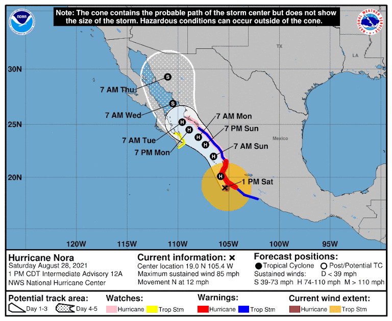
The track update now has the Nora coming ashore next Monday as a huricane.

B40D6DB7-14AE-4E15-91B1-4F0A4711A845.jpeg - 249kB

tiotomasbcs - 8-26-2021 at 02:47 PM

Sitting in the possible path of a big storm is a bit nerve racking even tho I've seen a few here in Todos Santos. Exciting but scary! Nice to have cement block house with solid roof! And a four wheel drive Truck. Generators and lots of provisions including Cerveza. Whoo Hoo....it's gonna blow!! Oh yeah...we need the rain....Ja, ja, ja!

pauldavidmena - 8-26-2021 at 02:50 PM

Quote: Originally posted by tiotomasbcs  
Sitting in the possible path of a big storm is a bit nerve racking even tho I've seen a few here in Todos Santos. Exciting but scary! Nice to have cement block house with solid roof! And a four wheel drive Truck. Generators and lots of provisions including Cerveza. Whoo Hoo....it's gonna blow!! Oh yeah...we need the rain....Ja, ja, ja!


Tropical Storm Henri was a big yawn in Cape Cod last weekend. I'm hoping the same for Nora in BCS.

mtgoat666 - 8-26-2021 at 03:52 PM

Nora forecast now shows Hurricane winds when making landfall at cabo, though path for baja hit is uncertain at this point, per latest from NHC

https://www.nhc.noaa.gov/?epac


000
WTPZ44 KNHC 262037
TCDEP4

Tropical Storm Nora Discussion Number 5
NWS National Hurricane Center Miami FL EP142021
400 PM CDT Thu Aug 26 2021

Scatterometer data from around midday showed that Nora has an
expansive circulation with tropical-storm-force winds nearly
reaching the coast of Mexico. The data also showed a possible
center embedded within a larger area of light winds, but it is
possible that there's another similar feature farther west where
the instrument did not sample. Nora's winds remain 35 kt based on
the ASCAT pass and the latest Dvorak fixes from TAFB and SAB, and
the center has been placed between the two dumb-belling vorticity
maxima.

Even with the updated position, Nora is moving toward the
west-northwest (285/8 kt), to the south of mid-level ridging over
the southern United States. A shortwave trough currently over the
northern Rockies is expected to erode the ridge over the next 12-24
hours, allowing Nora to turn toward the northwest and then
north-northwest by the weekend. Even with the GFS's solution of
multiple swirls consolidating over the next day or so, the 12Z run
shifted left and now shows Nora potentially moving inland over
Mexico farther west than it had in previous runs. A few of the
other models--for example the HWRF and HMON--also bring the center
inland as well, but the bulk of the interpolated model trackers
continue to keep Nora just offshore but very near the coast of
southwestern Mexico in about 48 hours. Model spread remains larger
than normal, but no significant changes were required from the
previous NHC track forecast based on the latest guidance suite.
After passing southwestern Mexico, Nora is expected to be over Baja
California Sur or the Gulf of California on days 4 and 5.

Moderate northeasterly shear continues to affect Nora, but that
shear is expected to decrease to a less-intrusive magnitude during
the next 24 hours. Along with warm sea surface temperatures of
28-30 degrees Celsius, a moist mid-level environment, and
upper-level divergence, Nora is expected to strengthen in the coming
days. The rate of intensification could, however, be tempered by
Nora's large size and structure. Assuming Nora does not move inland
over southwestern Mexico, the storm is expected to become a
hurricane on Saturday and then possibly continue strengthening up
until the point it reaches the Baja California Peninsula. Much of
the intensity guidance is based on scenarios showing Nora moving
inland, which is suppressing the intensity consensus aids.
Therefore, the NHC intensity forecast is mostly based on the
ECMWF-based SHIPS and LGEM models, since the parent ECMWF model does
not show Nora moving inland.

Given Nora's larger wind field, tropical-storm-force winds are
likely to reach the coast of Mexico earlier than expected.
Therefore, the government of Mexico has issued a Tropical Storm
Warning for a portion of the southwestern coast of Mexico. The
Hurricane Watch issued earlier today also remains in effect.

Key Messages:

1. Nora is forecast to strengthen to a hurricane by Saturday
while it is near the coast of southwestern Mexico, and a hurricane
watch and tropical storm warnings are in effect for portions of that
area. Interests along the southwestern coast of Mexico should
closely monitor the progress of this system and updates to the
forecast.

2. Heavy rain associated with Nora is expected across coastal
sections of the Mexican states of Oaxaca, Guerrero, Michoacan,
Colima, and Jalisco. As a result, life-threatening flash flooding
and mudslides could occur.

3. Nora is forecast to be near the southern portion of Baja California Sur as a hurricane early next week, bringing a risk of wind and rain impacts to that area. Given the above average uncertainty in the forecast, it is too soon to determine the magnitude and location of these potential impacts.


[Edited on 8-26-2021 by mtgoat666]

RFClark - 8-26-2021 at 05:45 PM

Goat,

The “consensus” of the models is there is none! Nora might go east or not! Nora is a good sized storm which may grow! We could know something Saturday!

JDCanuck - 8-26-2021 at 06:14 PM

Quote: Originally posted by tiotomasbcs  
Sitting in the possible path of a big storm is a bit nerve racking even tho I've seen a few here in Todos Santos. Exciting but scary! Nice to have cement block house with solid roof! And a four wheel drive Truck. Generators and lots of provisions including Cerveza. Whoo Hoo....it's gonna blow!! Oh yeah...we need the rain....Ja, ja, ja!


From what I see its going right over you. Sunday night or Monday very early, please keep us updated, our place is just a bit north of you and still not buttoned up.

Bajabus - 8-26-2021 at 06:16 PM

The issue I see is it appears to stall for about 24 hrs between Cabo and TS so who knows what rain fall totals will be.

having been thru a bunch of these down here these are my basic tips for this one for those off grid.
• Call and get your Propane tanks filled by Saturday.
• Fill gas tanks on vehicles and any cans you may have.
• Stock up on non-perishable foods, canned goods, etc.
• Freeze as many 1 gallon containers as you can.
• Five or so hours before the expected heavy rain, run your genny and top off batteries; if you don’t have a genny, get your batteries as full as possible by cutting down loads and saving energy.
• Double-check solar panel mounts and hanging loose wires.
• As the storm approaches and the rain begins, turn off all solar equipment, open battery disconnects to the inverters, and place frozen jugs in fridges—power down all electronic equipment. With wind-driven rain in the 70 to 90 MPH range, it gets in everywhere.
• Avoid opening fridges unless necessary. Think about what you are going to pull out before opening the door.
• Once the storm passes, look at your solar equipment, in particular the inverters. If they are wet or have visible condensation on them, do not start them. Wait for them to dry out or if you have a small genny that’s relatively dry, start it and get to work with a fan or hairdryer. Many people fry their inverters during these storms. Don’t start or touch solar system components in bare feet or wet shoes.
• Stay safe and check on your neighbors

RFClark - 8-26-2021 at 06:18 PM

We’re not there. We buttoned up and went north for August and September. There are people there so if the internet holds up we can get information on scene.

BB offers great advice. If you have storm shutters get them up soon! Buy gas, get pesos to last a week or 2! After Odile ATMs and CC machines were down for weeks.

[Edited on 8-27-2021 by RFClark]

Bajabus - 8-26-2021 at 06:34 PM

Oh, I almost forgot, get cash out of an ATM ASAP. They won’t refill until about Tuesday or Wed, and if the power goes out for a while, you are screwed, no CC transactions and only cash for transactions.


Bajabus - 8-26-2021 at 06:42 PM

Quote: Originally posted by RFClark  
get pesos to last a week or 2! After Odile ATMs and CC machines were down for weeks.

[Edited on 8-27-2021 by RFClark]


Ha ya beat me to it. As long as our internet is up we will update (Bajaconnect radio repeater network.) We also have a verizon hot spot on the telcel network but who knows if the towers will be able to maintain power.

For Juliet we had a full tilt comercial sat system, the only internet for miles around for weeks. This time.............

Latest wind arrival times

RFClark - 8-26-2021 at 06:59 PM


594FD406-B498-42EA-B44E-83F0257E9D09.jpeg - 216kB

JDCanuck - 8-26-2021 at 08:01 PM

Quote: Originally posted by Bajabus  
The issue I see is it appears to stall for about 24 hrs between Cabo and TS so who knows what rain fall totals will be.

having been thru a bunch of these down here these are my basic tips for this one for those off grid.
• Call and get your Propane tanks filled by Saturday.
• Fill gas tanks on vehicles and any cans you may have.
• Stock up on non-perishable foods, canned goods, etc.
• Freeze as many 1 gallon containers as you can.
• Five or so hours before the expected heavy rain, run your genny and top off batteries; if you don’t have a genny, get your batteries as full as possible by cutting down loads and saving energy.
• Double-check solar panel mounts and hanging loose wires.
• As the storm approaches and the rain begins, turn off all solar equipment, open battery disconnects to the inverters, and place frozen jugs in fridges—power down all electronic equipment. With wind-driven rain in the 70 to 90 MPH range, it gets in everywhere.
• Avoid opening fridges unless necessary. Think about what you are going to pull out before opening the door.
• Once the storm passes, look at your solar equipment, in particular the inverters. If they are wet or have visible condensation on them, do not start them. Wait for them to dry out or if you have a small genny that’s relatively dry, start it and get to work with a fan or hairdryer. Many people fry their inverters during these storms. Don’t start or touch solar system components in bare feet or wet shoes.
• Stay safe and check on your neighbors


Thanks for that very helpful info.

JDCanuck - 8-26-2021 at 08:10 PM

What wind speeds did Odile hit at Todos Santos? We have been in slightly higher wind speeds in Northern BC but trying to compare to something that's hit previously down there.

[Edited on 8-27-2021 by JDCanuck]

Bajabus - 8-26-2021 at 08:34 PM

I was not here for Odile but Juliette hit as a Cat 4 with 145mph winds and dumped 20 inches of rain. Here in Elias Calles we were cutoff and stranded for almost 5 weeks and relied on Mexican Military Helicopter food and water drops. About 35 people in cars and a bus were stuck with us including a honeymoon couple on their way to Cabo. We all had a great time for the first 2-3 weeks, then the booze and food ran out. The wind really was not the worst, the rain was a killer and wreaked much havoc.

JDCanuck - 8-26-2021 at 08:39 PM

Quote: Originally posted by Bajabus  
I was not here for Odile but Juliette hit as a Cat 4 with 145mph winds and dumped 20 inches of rain. Here in Elias Calles we were cutoff and stranded for almost 5 weeks and relied on Mexican Military Helicopter food and water drops. About 35 people in cars and a bus were stuck with us including a honeymoon couple on their way to Cabo. We all had a great time for the first 2-3 weeks, then the booze and food ran out. The wind really was not the worst, the rain was a killer and wreaked much havoc.


Thanks, I found it here:
https://www.nasa.gov/content/goddard/odile-eastern-pacific/
So far at our place it's estimated Nora will be less than 1/3 the sustained speeds of Odile once it gets there. Odile...that was a huge one, as well as the one you mentioned. No experience whatsoever with winds that high. And looks like the rain will be the biggest issue we.

[Edited on 8-27-2021 by JDCanuck]

Bajabus - 8-26-2021 at 08:55 PM

Quote: Originally posted by JDCanuck  
So far at our place it's estimated Nora will be less than 1/2 the sustained speeds of Odile once it gets there. Man Odile...that was a huge one, as well as the one you mentioned.


The year is still young.

JDCanuck - 8-26-2021 at 09:31 PM

Yes will be an interesting visit. We should be there in a 3 weeks for the next month after that. Might see some more heavy weather.

Nora may come ashore Sunday Night

RFClark - 8-26-2021 at 11:01 PM


Make your plans tomorrow Nora may come ashore overnight Sunday!

D94F1C71-7DA6-416A-BCA0-F79D690D9581.jpeg - 256kB

RFClark - 8-27-2021 at 05:20 AM

5:00 PDT

The NOAA site is down probably from excess traffic. The takeaway from the discussion is:

1) Nora’s course past 36 hours is uncertain.
2) Nora may interact with the Mexican mainland south of Baja Sur.
3) Nora may go up the gulf early next week. If it does HWY1 will take a beating in the Ligui - Santa Roselia area.
4) Anyone in LA Bay should be prepared if the storm goes up the gulf.
5) Areas as far north as San Felipe could receive heavy rain fall midweek. Hwy5 South of San Felipe could take a beating from heavy rain.

I will post a new map as soon as NOAA is back up.


[Edited on 8-27-2021 by RFClark]

mtgoat666 - 8-27-2021 at 07:20 AM

Quote: Originally posted by RFClark  
5:00 PDT

The NOAA site is down probably from excess traffic. The takeaway from the discussion is:

1) Nora’s course past 36 hours is uncertain.
2) Nora may interact with the Mexican mainland south of Baja Sur.
3) Nora may go up the gulf early next week. If it does HWY1 will take a beating in the Ligui - Santa Roselia area.
4) Anyone in LA Bay should be prepared if the storm goes up the gulf.
5) Areas as far north as San Felipe could receive heavy rain fall midweek. Hwy5 South of San Felipe could take a beating from heavy rain.

I will post a new map as soon as NOAA is back up.


[Edited on 8-27-2021 by RFClark]


NOAA nhc website works fine!

All the latest maps are there

https://www.nhc.noaa.gov/?epac


Latest Nora Storm Track

RFClark - 8-27-2021 at 09:25 AM


37A4619E-4FE4-4DAD-A3BE-42B22869EA43.jpeg - 252kB

3. Nora is forecast to move over the Gulf of California as a
hurricane early next week, bringing a risk of wind and rain impacts
to portions of the Mexican states of Baja California Sur, Sinaloa,
and Sonora. Given the above-average uncertainty in the forecast,
it is still too soon to determine the magnitude and location of
these potential impacts.

FORECAST POSITIONS AND MAX WINDS

INIT 27/1500Z 15.4N 104.3W 45 KT 50 MPH
12H 28/0000Z 16.3N 105.2W 50 KT 60 MPH
24H 28/1200Z 17.9N 105.9W 60 KT 70 MPH
36H 29/0000Z 19.9N 106.5W 65 KT 75 MPH
48H 29/1200Z 21.7N 107.4W 70 KT 80 MPH
60H 30/0000Z 23.1N 108.3W 75 KT 85 MPH
72H 30/1200Z 24.2N 109.1W 75 KT 85 MPH
96H 31/1200Z 26.1N 110.7W 65 KT 75 MPH
120H 01/1200Z 28.4N 111.7W 50 KT 60 MPH


[Edited on 8-27-2021 by RFClark]

Time for storm chasing?

AKgringo - 8-27-2021 at 10:09 AM

Storm chasing.....What a blast!

Storm catching....What was I thinking?

shari - 8-27-2021 at 11:34 AM

I am happy for the folks in the Sierras...be safe all of you down below! Now taking bets for no rain in Asuncion....

RFClark - 8-27-2021 at 12:13 PM

The NOAA 2:00 PM update hasn't changed much. That said the Cabo Hotels are getting out the plywood so!

Don Pisto - 8-27-2021 at 12:28 PM

come on Nora bring us rain! you can do it

Nora vs Ida

RFClark - 8-27-2021 at 02:04 PM

Note how much larger Nora is. If it gets as far north as Baja Sur it could be a real rain producer.

1F43BBB2-FC3B-43AA-AEFF-69C5F6B3D5AA.jpeg - 229kB

4x4abc - 8-27-2021 at 04:57 PM

Quote: Originally posted by Don Pisto  
come on Nora bring us rain! you can do it

10" forecast for La Paz

TS Nora Friday Evening update

RFClark - 8-27-2021 at 10:14 PM


95072C8A-F3AD-4891-BB12-DC81E789DA8D.jpeg - 258kB

3. Nora is forecast to move over the Gulf of California as a
hurricane early next week, bringing a risk of wind and rain impacts
to portions of the Mexican states of Baja California Sur, Sinaloa,
and Sonora. Given the above-average uncertainty in the forecast,
it is still too soon to determine the magnitude and location of
these potential impacts.


FORECAST POSITIONS AND MAX WINDS

INIT 28/0300Z 16.3N 105.1W 55 KT 65 MPH
12H 28/1200Z 17.6N 105.6W 60 KT 70 MPH
24H 29/0000Z 19.6N 106.2W 65 KT 75 MPH
36H 29/1200Z 21.6N 107.0W 70 KT 80 MPH
48H 30/0000Z 22.7N 107.9W 75 KT 85 MPH
60H 30/1200Z 23.6N 108.6W 80 KT 90 MPH
72H 31/0000Z 24.5N 109.3W 80 KT 90 MPH
96H 01/0000Z 26.5N 111.0W 70 KT 80 MPH
120H 02/0000Z 29.5N 111.5W 45 KT 50 MPH...INLAND

Bob and Susan - 8-28-2021 at 05:24 AM

i love these "tracks"
it makes it look so small
when in reality the thing is HUGE

pauldavidmena - 8-28-2021 at 12:19 PM

The current track shows Nora bending closer to the mainland while churning up the Sea of Cortes.


RFClark - 8-28-2021 at 05:22 PM


2. Heavy rain associated with Nora is expected across the west coast
of Mexico from the Mexican states of Guerrero, northward to southern
Sonora, including Baja California Sur. This rain will likely
result in life-threatening flash flooding and mudslides across these
regions. Rainfall from Nora may spread into the southwestern U.S.
and central Rockies during the middle to latter portion of next
week.

3. Nora is forecast to continue moving northward over the Gulf of
California Tuesday and Wednesday, bringing a risk of wind impacts to
portions of the Mexican states of Baja California Sur, northern
Sinaloa, and Sonora. Given the above-average uncertainty in the
forecast intensity, confidence is not high enough to determine the
magnitude and location of these potential impacts.


FORECAST POSITIONS AND MAX WINDS

INIT 28/2100Z 19.7N 105.4W 75 KT 85 MPH...ON THE COAST
12H 29/0600Z 21.5N 105.9W 75 KT 85 MPH
24H 29/1800Z 22.9N 106.7W 75 KT 85 MPH
36H 30/0600Z 23.5N 107.4W 75 KT 85 MPH
48H 30/1800Z 24.2N 108.1W 75 KT 85 MPH
60H 31/0600Z 24.8N 108.9W 70 KT 80 MPH
72H 31/1800Z 25.6N 109.5W 70 KT 80 MPH
96H 01/1800Z 27.6N 110.4W 55 KT 65 MPH...INLAND
120H 02/1800Z 29.4N 110.6W 30 KT 35 MPH...INLAND


D870C3BF-B869-4F45-BB1D-8FB3D6E5CFB5.jpeg - 256kB

phmilo - 8-28-2021 at 06:15 PM

Glad to see it bending East. We are headed down on Wednesday, I might need to upgrade to a 4x4 if the rains are heavy.

Bajazly - 8-28-2021 at 06:55 PM

San Felipe needs rain bad, turn westward after Bahia de Los Angeles. Nice warm water up here in the northern part of the Cortez.

JDCanuck - 8-28-2021 at 09:11 PM

Am I right in seeing it breaking up and weakening around Tepic?

BornFisher - 8-28-2021 at 09:20 PM

Be careful what you wish for. This looks like the real deal, going to be some serious storm damage and the possible loss of many lives.
John Ireland (East Cape, Rancho Leonero) always says the storms that come up the gulf are the worst.

JDCanuck - 8-28-2021 at 09:45 PM

I've had the pin placed here for a while now, both wind gust speeds and rainfall slowly declining.
https://www.windy.com/23.060/-109.700?gust,21.136,-107.990,7

mtgoat666 - 8-29-2021 at 07:01 AM

Baja dodged the bullet on this one. Will get some precip, and avoid the tropical and hurricane strength winds

JDCanuck - 8-29-2021 at 07:05 AM

Airport at San Jose del Cabo looks good still, Todos Santos and 50 miles north moderating as well, but Thursday now looks like slightly higher winds, and very little rain between now and then. Mixed blessings I guess.

[Edited on 8-29-2021 by JDCanuck]

pauldavidmena - 8-29-2021 at 07:40 AM

Quote: Originally posted by phmilo  
Glad to see it bending East. We are headed down on Wednesday, I might need to upgrade to a 4x4 if the rains are heavy.


As a vicarious stowaway, I'm quite relieved. :)

Bajabus - 8-29-2021 at 07:54 AM

Elias Calles
Very light wind out of the NW with heavy overcast. 81 degrees temp and 87% humidity.

Nora downgraded to a Tropical Stotm

RFClark - 8-29-2021 at 08:20 AM


D6F3A21A-23DA-4AF5-A539-3209E75485B5.jpeg - 249kB

3. Nora is forecast to move north-northwestward to northwestward
near or over the Gulf of California Tuesday and Wednesday, bringing
a risk of wind impacts to portions of the Mexican states of Baja
California Sur, northern Sinaloa, and Sonora. Given the
above-average uncertainty in the intensity forecast, confidence is
not high enough to determine the magnitude and location of these
potential impacts.

FORECAST POSITIONS AND MAX WINDS

INIT 29/1500Z 23.3N 106.4W 65 KT 75 MPH
12H 30/0000Z 23.8N 106.9W 60 KT 70 MPH...NEAR THE COAST
24H 30/1200Z 24.3N 107.5W 55 KT 65 MPH...NEAR THE COAST
36H 31/0000Z 24.9N 108.2W 55 KT 65 MPH...NEAR THE COAST
48H 31/1200Z 25.6N 109.0W 50 KT 60 MPH...NEAR THE COAST
60H 01/0000Z 26.5N 109.6W 50 KT 60 MPH...NEAR THE COAST
72H 01/1200Z 27.5N 110.0W 40 KT 45 MPH...INLAND
96H 02/1200Z 29.5N 111.2W 30 KT 35 MPH...INLAND
120H 03/1200Z...DISSIPATED

Bajabus - 8-29-2021 at 09:11 AM

Quote: Originally posted by JDCanuck  
Airport at San Jose del Cabo looks good still
[Edited on 8-29-2021 by JDCanuck]


JD how are you checking the airport status?

Bajabus - 8-29-2021 at 02:08 PM

Elias Calles
Cloud cover is getting thicker, The Sierras to our east are completely obscured. Winds have picked up and are more out of the West. Humidity has dropped to 74%, temp is still 87 but it feels much cooler. Liking this so far.

JDCanuck - 8-29-2021 at 02:18 PM

Quote: Originally posted by Bajabus  
Quote: Originally posted by JDCanuck  
Airport at San Jose del Cabo looks good still
[Edited on 8-29-2021 by JDCanuck]


JD how are you checking the airport status?


I posted the WINDY link earlier with a Pin for the airport location. Here it is again

https://www.windy.com/23.060/-109.700?gust,22.483,-109.700,8

[Edited on 8-29-2021 by JDCanuck] I have ridden my motorbike in cross wind gusts right around that intensity and is tiring but not especially bad unless you have a tall rig or motorhome. By your name, do you possibly have a bus you are driving?
My concern was based on possible damage at the airport which might prevent us flying in in a couple weeks. Predictions yesterday around this time were for gusts at twice this speed.

[Edited on 8-29-2021 by JDCanuck]

Bajabus - 8-29-2021 at 02:25 PM

Quote: Originally posted by JDCanuck  
Quote: Originally posted by Bajabus  
Quote: Originally posted by JDCanuck  
Airport at San Jose del Cabo looks good still
[Edited on 8-29-2021 by JDCanuck]


JD how are you checking the airport status?


I posted the WINDY link earlier with a Pin for the airport location. Here it is again

https://www.windy.com/23.060/-109.700?gust,22.483,-109.700,8

[Edited on 8-29-2021 by JDCanuck]


Ah OK I see now. I was looking for actual info on if it closes at some point. Thanks!

elgatoloco - 8-30-2021 at 06:53 PM

Calling Bajabus........

Hope all is OK.

Bajabus - 8-31-2021 at 03:33 PM

Quote: Originally posted by elgatoloco  
Calling Bajabus........

Hope all is OK.


It was pretty much a nothing burger in Elias Calles.

All is good Gatto.

elgatoloco - 8-31-2021 at 04:04 PM

Quote: Originally posted by Bajabus  
Quote: Originally posted by elgatoloco  
Calling Bajabus........

Hope all is OK.


It was pretty much a nothing burger in Elias Calles.

All is good Gatto.


Good to hear. I for one will never forget your 'on the scene' reporting during Juliette. Seems like yesterday. When your connection finally dropped we had our hearts in our throats. Give the familia abrazos from us. :cool:

Bob H - 8-31-2021 at 04:06 PM

Glad that Mulege was spared.

David K - 8-31-2021 at 04:53 PM

Hasn't gotten there, yet. Tonight to tomorrow morning it looks like from the map above?

AKgringo - 8-31-2021 at 05:13 PM

Quote: Originally posted by David K  
Hasn't gotten there, yet. Tonight to tomorrow morning it looks like from the map above?


That was just a forecast. The storm seems to have fallen apart!