| Pages:
1
2
3 |
RFClark
Super Nomad
   
Posts: 2470
Registered: 8-27-2015
Member Is Offline
Mood: Delighted with 2024 and looking forward to 2025
|
|
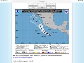
Hurricane Nora coming to Baja Sur
This is the forecast currently.

[Edited on 8-27-2021 by BajaNomad]
|
|
|
AKgringo
Elite Nomad
     
Posts: 6337
Registered: 9-20-2014
Location: Anchorage, AK (no mas!)
Member Is Offline
Mood: Retireded
|
|
Windy.com shows it just hammering Los Cabos by noon on Sunday! That is just a forecast, a lot could change in the next couple of days.
https://www.windy.com/?2021082921,27.294,-103.667,4
If you are not living on the edge, you are taking up too much space!
"Could do better if he tried!" Report card comments from most of my grade school teachers. Sadly, still true!
|
|
|
BajaBill74
Nomad
 
Posts: 255
Registered: 1-27-2014
Member Is Offline
Mood: Beyond Extatic!
|
|
Hurricane Nora
It looks like Hurricane Nora could reach Los Cabos on Tuesday with 40% chance of tropical Tropical Force winds.
What I'm doing at work is so secret, even I don't know what I'm doing!
One should believe in God, because even Google doesn't know everything.
|
|
|
RFClark
Super Nomad
   
Posts: 2470
Registered: 8-27-2015
Member Is Offline
Mood: Delighted with 2024 and looking forward to 2025
|
|
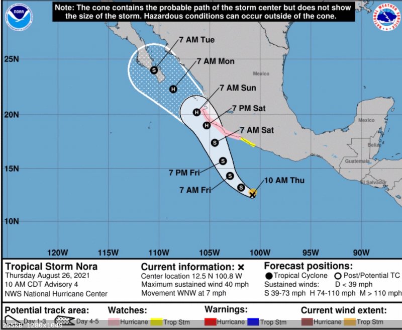
Tropical Storm Nora 8/26 update

|
|
|
RFClark
Super Nomad
   
Posts: 2470
Registered: 8-27-2015
Member Is Offline
Mood: Delighted with 2024 and looking forward to 2025
|
|
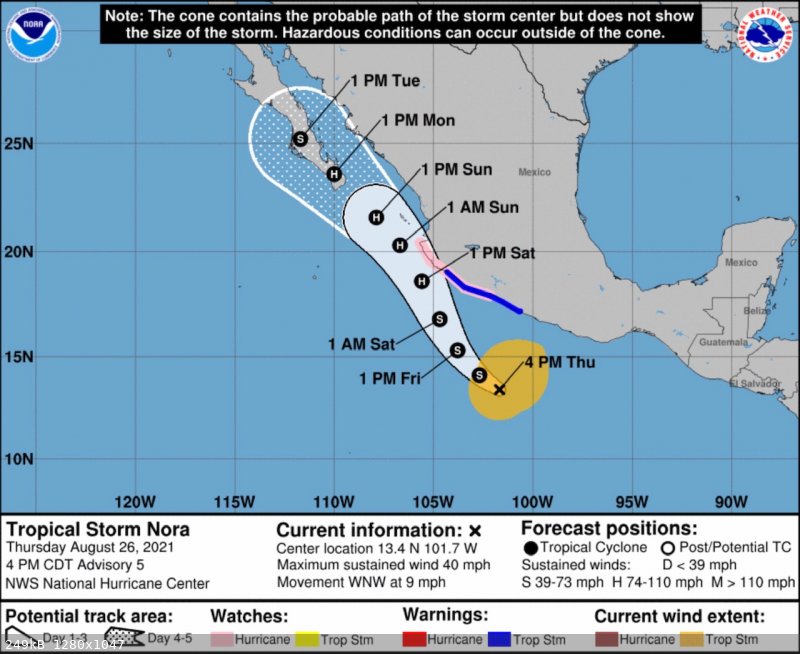
Latest Nora Track update
The track update now has the Nora coming ashore next Monday as a huricane.

|
|
|
tiotomasbcs
Super Nomad
   
Posts: 1837
Registered: 7-30-2007
Location: El Pescadero
Member Is Offline
|
|
Sitting in the possible path of a big storm is a bit nerve racking even tho I've seen a few here in Todos Santos. Exciting but scary! Nice to have
cement block house with solid roof! And a four wheel drive Truck. Generators and lots of provisions including Cerveza. Whoo Hoo....it's gonna blow!!
Oh yeah...we need the rain....Ja, ja, ja!
|
|
|
pauldavidmena
Super Nomad
   
Posts: 1808
Registered: 5-23-2013
Location: Centerville, MA, USA
Member Is Offline
|
|
Quote: Originally posted by tiotomasbcs  | | Sitting in the possible path of a big storm is a bit nerve racking even tho I've seen a few here in Todos Santos. Exciting but scary! Nice to have
cement block house with solid roof! And a four wheel drive Truck. Generators and lots of provisions including Cerveza. Whoo Hoo....it's gonna blow!!
Oh yeah...we need the rain....Ja, ja, ja! |
Tropical Storm Henri was a big yawn in Cape Cod last weekend. I'm hoping the same for Nora in BCS.
|
|
|
mtgoat666
Platinum Nomad
       
Posts: 20900
Registered: 9-16-2006
Location: San Diego
Member Is Offline
Mood: Hot n spicy
|
|
Nora forecast now shows Hurricane winds when making landfall at cabo, though path for baja hit is uncertain at this point, per latest from NHC
https://www.nhc.noaa.gov/?epac
000
WTPZ44 KNHC 262037
TCDEP4
Tropical Storm Nora Discussion Number 5
NWS National Hurricane Center Miami FL EP142021
400 PM CDT Thu Aug 26 2021
Scatterometer data from around midday showed that Nora has an
expansive circulation with tropical-storm-force winds nearly
reaching the coast of Mexico. The data also showed a possible
center embedded within a larger area of light winds, but it is
possible that there's another similar feature farther west where
the instrument did not sample. Nora's winds remain 35 kt based on
the ASCAT pass and the latest Dvorak fixes from TAFB and SAB, and
the center has been placed between the two dumb-belling vorticity
maxima.
Even with the updated position, Nora is moving toward the
west-northwest (285/8 kt), to the south of mid-level ridging over
the southern United States. A shortwave trough currently over the
northern Rockies is expected to erode the ridge over the next 12-24
hours, allowing Nora to turn toward the northwest and then
north-northwest by the weekend. Even with the GFS's solution of
multiple swirls consolidating over the next day or so, the 12Z run
shifted left and now shows Nora potentially moving inland over
Mexico farther west than it had in previous runs. A few of the
other models--for example the HWRF and HMON--also bring the center
inland as well, but the bulk of the interpolated model trackers
continue to keep Nora just offshore but very near the coast of
southwestern Mexico in about 48 hours. Model spread remains larger
than normal, but no significant changes were required from the
previous NHC track forecast based on the latest guidance suite.
After passing southwestern Mexico, Nora is expected to be over Baja
California Sur or the Gulf of California on days 4 and 5.
Moderate northeasterly shear continues to affect Nora, but that
shear is expected to decrease to a less-intrusive magnitude during
the next 24 hours. Along with warm sea surface temperatures of
28-30 degrees Celsius, a moist mid-level environment, and
upper-level divergence, Nora is expected to strengthen in the coming
days. The rate of intensification could, however, be tempered by
Nora's large size and structure. Assuming Nora does not move inland
over southwestern Mexico, the storm is expected to become a
hurricane on Saturday and then possibly continue strengthening up
until the point it reaches the Baja California Peninsula. Much of
the intensity guidance is based on scenarios showing Nora moving
inland, which is suppressing the intensity consensus aids.
Therefore, the NHC intensity forecast is mostly based on the
ECMWF-based SHIPS and LGEM models, since the parent ECMWF model does
not show Nora moving inland.
Given Nora's larger wind field, tropical-storm-force winds are
likely to reach the coast of Mexico earlier than expected.
Therefore, the government of Mexico has issued a Tropical Storm
Warning for a portion of the southwestern coast of Mexico. The
Hurricane Watch issued earlier today also remains in effect.
Key Messages:
1. Nora is forecast to strengthen to a hurricane by Saturday
while it is near the coast of southwestern Mexico, and a hurricane
watch and tropical storm warnings are in effect for portions of that
area. Interests along the southwestern coast of Mexico should
closely monitor the progress of this system and updates to the
forecast.
2. Heavy rain associated with Nora is expected across coastal
sections of the Mexican states of Oaxaca, Guerrero, Michoacan,
Colima, and Jalisco. As a result, life-threatening flash flooding
and mudslides could occur.
3. Nora is forecast to be near the southern portion of Baja California Sur as a hurricane early next week, bringing a risk of wind and rain
impacts to that area. Given the above average uncertainty in the forecast, it is too soon to determine the magnitude and location of these potential
impacts.
[Edited on 8-26-2021 by mtgoat666]
Woke!
Hands off!
“Por el bien de todos, primero los pobres.”
“...ask not what your country can do for you – ask what you can do for your country.” “My fellow citizens of the world: ask not what America
will do for you, but what together we can do for the freedom of man.”
Pronoun: the royal we
|
|
|
BajaNomad
|
Threads Merged
8-26-2021 at 05:31 PM |
RFClark
Super Nomad
   
Posts: 2470
Registered: 8-27-2015
Member Is Offline
Mood: Delighted with 2024 and looking forward to 2025
|
|
Goat,
The “consensus” of the models is there is none! Nora might go east or not! Nora is a good sized storm which may grow! We could know something
Saturday!
|
|
|
JDCanuck
Ultra Nomad
    
Posts: 2557
Registered: 2-22-2020
Member Is Offline
|
|
Quote: Originally posted by tiotomasbcs  | | Sitting in the possible path of a big storm is a bit nerve racking even tho I've seen a few here in Todos Santos. Exciting but scary! Nice to have
cement block house with solid roof! And a four wheel drive Truck. Generators and lots of provisions including Cerveza. Whoo Hoo....it's gonna blow!!
Oh yeah...we need the rain....Ja, ja, ja! |
From what I see its going right over you. Sunday night or Monday very early, please keep us updated, our place is just a bit north of you and still
not buttoned up.
|
|
|
Bajabus
Senior Nomad
  
Posts: 892
Registered: 8-30-2002
Location: Elias Calles B.C.S. or NC USA
Member Is Offline
Mood: My friends..it's good.
|
|
The issue I see is it appears to stall for about 24 hrs between Cabo and TS so who knows what rain fall totals will be.
having been thru a bunch of these down here these are my basic tips for this one for those off grid.
• Call and get your Propane tanks filled by Saturday.
• Fill gas tanks on vehicles and any cans you may have.
• Stock up on non-perishable foods, canned goods, etc.
• Freeze as many 1 gallon containers as you can.
• Five or so hours before the expected heavy rain, run your genny and top off batteries; if you don’t have a genny, get your batteries as full as
possible by cutting down loads and saving energy.
• Double-check solar panel mounts and hanging loose wires.
• As the storm approaches and the rain begins, turn off all solar equipment, open battery disconnects to the inverters, and place frozen jugs in
fridges—power down all electronic equipment. With wind-driven rain in the 70 to 90 MPH range, it gets in everywhere.
• Avoid opening fridges unless necessary. Think about what you are going to pull out before opening the door.
• Once the storm passes, look at your solar equipment, in particular the inverters. If they are wet or have visible condensation on them, do not
start them. Wait for them to dry out or if you have a small genny that’s relatively dry, start it and get to work with a fan or hairdryer. Many
people fry their inverters during these storms. Don’t start or touch solar system components in bare feet or wet shoes.
• Stay safe and check on your neighbors
"Preventive war was an invention of Hitler. Frankly I would not even listen to anyone seriously that came and talked of such a thing."
Dwight David Eisenhower
|
|
|
RFClark
Super Nomad
   
Posts: 2470
Registered: 8-27-2015
Member Is Offline
Mood: Delighted with 2024 and looking forward to 2025
|
|
We’re not there. We buttoned up and went north for August and September. There are people there so if the internet holds up we can get information
on scene.
BB offers great advice. If you have storm shutters get them up soon! Buy gas, get pesos to last a week or 2! After Odile ATMs and CC machines were
down for weeks.
[Edited on 8-27-2021 by RFClark]
|
|
|
Bajabus
Senior Nomad
  
Posts: 892
Registered: 8-30-2002
Location: Elias Calles B.C.S. or NC USA
Member Is Offline
Mood: My friends..it's good.
|
|
Oh, I almost forgot, get cash out of an ATM ASAP. They won’t refill until about Tuesday or Wed, and if the power goes out for a while, you are
screwed, no CC transactions and only cash for transactions.
"Preventive war was an invention of Hitler. Frankly I would not even listen to anyone seriously that came and talked of such a thing."
Dwight David Eisenhower
|
|
|
Bajabus
Senior Nomad
  
Posts: 892
Registered: 8-30-2002
Location: Elias Calles B.C.S. or NC USA
Member Is Offline
Mood: My friends..it's good.
|
|
Quote: Originally posted by RFClark  | get pesos to last a week or 2! After Odile ATMs and CC machines were down for weeks.
[Edited on 8-27-2021 by RFClark] |
Ha ya beat me to it. As long as our internet is up we will update (Bajaconnect radio repeater network.) We also have a verizon hot spot on the
telcel network but who knows if the towers will be able to maintain power.
For Juliet we had a full tilt comercial sat system, the only internet for miles around for weeks. This time.............
"Preventive war was an invention of Hitler. Frankly I would not even listen to anyone seriously that came and talked of such a thing."
Dwight David Eisenhower
|
|
|
RFClark
Super Nomad
   
Posts: 2470
Registered: 8-27-2015
Member Is Offline
Mood: Delighted with 2024 and looking forward to 2025
|
|
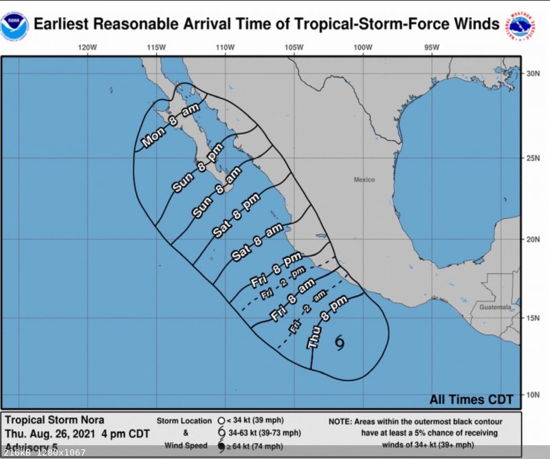
Latest wind arrival times

|
|
|
JDCanuck
Ultra Nomad
    
Posts: 2557
Registered: 2-22-2020
Member Is Offline
|
|
Quote: Originally posted by Bajabus  | The issue I see is it appears to stall for about 24 hrs between Cabo and TS so who knows what rain fall totals will be.
having been thru a bunch of these down here these are my basic tips for this one for those off grid.
• Call and get your Propane tanks filled by Saturday.
• Fill gas tanks on vehicles and any cans you may have.
• Stock up on non-perishable foods, canned goods, etc.
• Freeze as many 1 gallon containers as you can.
• Five or so hours before the expected heavy rain, run your genny and top off batteries; if you don’t have a genny, get your batteries as full as
possible by cutting down loads and saving energy.
• Double-check solar panel mounts and hanging loose wires.
• As the storm approaches and the rain begins, turn off all solar equipment, open battery disconnects to the inverters, and place frozen jugs in
fridges—power down all electronic equipment. With wind-driven rain in the 70 to 90 MPH range, it gets in everywhere.
• Avoid opening fridges unless necessary. Think about what you are going to pull out before opening the door.
• Once the storm passes, look at your solar equipment, in particular the inverters. If they are wet or have visible condensation on them, do not
start them. Wait for them to dry out or if you have a small genny that’s relatively dry, start it and get to work with a fan or hairdryer. Many
people fry their inverters during these storms. Don’t start or touch solar system components in bare feet or wet shoes.
• Stay safe and check on your neighbors
|
Thanks for that very helpful info.
|
|
|
JDCanuck
Ultra Nomad
    
Posts: 2557
Registered: 2-22-2020
Member Is Offline
|
|
What wind speeds did Odile hit at Todos Santos? We have been in slightly higher wind speeds in Northern BC but trying to compare to something that's
hit previously down there.
[Edited on 8-27-2021 by JDCanuck]
|
|
|
Bajabus
Senior Nomad
  
Posts: 892
Registered: 8-30-2002
Location: Elias Calles B.C.S. or NC USA
Member Is Offline
Mood: My friends..it's good.
|
|
I was not here for Odile but Juliette hit as a Cat 4 with 145mph winds and dumped 20 inches of rain. Here in Elias Calles we were cutoff and stranded
for almost 5 weeks and relied on Mexican Military Helicopter food and water drops. About 35 people in cars and a bus were stuck with us including a
honeymoon couple on their way to Cabo. We all had a great time for the first 2-3 weeks, then the booze and food ran out. The wind really was not the
worst, the rain was a killer and wreaked much havoc.
"Preventive war was an invention of Hitler. Frankly I would not even listen to anyone seriously that came and talked of such a thing."
Dwight David Eisenhower
|
|
|
JDCanuck
Ultra Nomad
    
Posts: 2557
Registered: 2-22-2020
Member Is Offline
|
|
Quote: Originally posted by Bajabus  | | I was not here for Odile but Juliette hit as a Cat 4 with 145mph winds and dumped 20 inches of rain. Here in Elias Calles we were cutoff and stranded
for almost 5 weeks and relied on Mexican Military Helicopter food and water drops. About 35 people in cars and a bus were stuck with us including a
honeymoon couple on their way to Cabo. We all had a great time for the first 2-3 weeks, then the booze and food ran out. The wind really was not the
worst, the rain was a killer and wreaked much havoc. |
Thanks, I found it here:
https://www.nasa.gov/content/goddard/odile-eastern-pacific/
So far at our place it's estimated Nora will be less than 1/3 the sustained speeds of Odile once it gets there. Odile...that was a huge one, as well
as the one you mentioned. No experience whatsoever with winds that high. And looks like the rain will be the biggest issue we.
[Edited on 8-27-2021 by JDCanuck]
|
|
|
Bajabus
Senior Nomad
  
Posts: 892
Registered: 8-30-2002
Location: Elias Calles B.C.S. or NC USA
Member Is Offline
Mood: My friends..it's good.
|
|
Quote: Originally posted by JDCanuck  | | So far at our place it's estimated Nora will be less than 1/2 the sustained speeds of Odile once it gets there. Man Odile...that was a huge one, as
well as the one you mentioned. |
The year is still young.
"Preventive war was an invention of Hitler. Frankly I would not even listen to anyone seriously that came and talked of such a thing."
Dwight David Eisenhower
|
|
|
| Pages:
1
2
3 |

