Ken Cooke
Elite Nomad
     
Posts: 8970
Registered: 2-9-2004
Location: Riverside, CA
Member Is Offline
Mood: Pole Line Road postponed due to injury
|
|
2 Jeeps in Baja!
Today, Baja Brad and I scrapped our plans of traveling to Puerto Penasco (due to lodging logistics). Instead, we're gonna check out Mission Santa
Maria in our Jeeps, El Marmol, and Catavina. Does anybody have any good advice on additional places to check out on our 4 day trip? We plan to drive
south into San Felipe, then, south to Punta Final, then north along Hwy 1 back to the USA. It should be a blast.
|
|
|
bajalou
Ultra Nomad
    
Posts: 4459
Registered: 3-11-2004
Location: South of the broder
Member Is Offline
|
|
When is all this happening Ken? Sounds like a good FAST trip.

No Bad Days
\"Never argue with an idiot. People watching may not be able to tell the difference\"
\"The trouble with doing nothing is - how do I know when I\'m done?\"
Nomad Baja Interactive map
And in the San Felipe area - check out Valle Chico area |
|
|
Neal Johns
Super Nomad
   
Posts: 1687
Registered: 10-31-2002
Location: Lytle Creek, CA
Member Is Offline
Mood: In love!
|
|
Check out Tinaja Yubay.
My motto:
Never let a Dragon pass by without pulling its tail!
|
|
|
John M
Super Nomad
   
Posts: 1924
Registered: 9-3-2003
Location: California High Desert
Member Is Offline
|
|
Along to way to Yubay
Following my grandfather's advice to go to Yubay, you ought to take the route through the Calamajue arroyo, especially if you haven't done so before.
|
|
|
TMW
Select Nomad
      
Posts: 10659
Registered: 9-1-2003
Location: Bakersfield, CA
Member Is Offline
|
|
Check out the Turquesa digs and water pools just north of Las Arrastras before Coco's Corner, this is also a short cut for bikes from hwy 1 if your an
excellent rider. Say high to Coco and if you can, take him some 7up. I think it was Corky that told me he likes 7up. Also if you have time look for
the old trail road to the mission from hwy 1 near KM187 at San Ignacito, either from the hwy side or the mission side. I've looked for it but never
found it. It may not be passable in a 4 wheeler.
|
|
|
bajajudy
Elite Nomad
     
Posts: 6886
Registered: 10-4-2004
Location: San Jose del Cabo,BCS
Member Is Offline
|
|
Ken
Why dont you guys go in together and buy a
HUMMER
|
|
|
David K
Honored Nomad
        
Posts: 65411
Registered: 8-30-2002
Location: San Diego County
Member Is Offline
Mood: Have Baja Fever
|
|
El Volcan, just 4 miles NE from El Marmol is an excellent side trip.
See http://vivabaja.com/403 for Mision Santa Maria and El Volcan...
The road continues almost 2 miles past the mission (at 1 1/2 mi. note that it climbs left out of the arroyo, the track ahead ends at a Palm grove).
Near the point where the bulldozed road becomes inpassable, the El Camino Real climbs left up the side valley towards Gonzaga Bay...
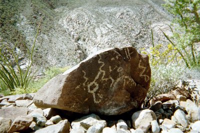
If you walk up the bulldozed roadbed to the summit, you will have a great view into the canyon leading to Gonzaga, see petroglyphs on rocks, and see
the Indian Trail head down the side of the canyon *this was the original Camino Real route as well.. then Serra (1769) had a better route made for
pack animals.
Yubay is way south of your planned route, off the road to L.A. Bay... Calamajueis fun, but again takes you south... depends on how much time you got.
|
|
|
Ken Cooke
Elite Nomad
     
Posts: 8970
Registered: 2-9-2004
Location: Riverside, CA
Member Is Offline
Mood: Pole Line Road postponed due to injury
|
|
We have only 4 days for our trip. Wed., Thurs. Fri., and Sat.
We plan to drive south to San Luis Gonzaga area and camp 1 night. Next 2 nights camp near Catavina region with lots of opportunities for our locked
and lifted Jeeps to play around.
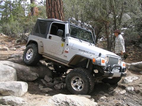
My Jeep is lifted 4" with 33" BFGoodrich All-Terrains (new), 4:1 T.C., Air Locked front/rear, etc., etc.
Baja Brad has a long-arm suspension on a Jeep Cherokee, lifted 5" w/33" BFGoodrich All-Terrains, Atlas Transfer case, Air Locked front/rear, York air
compressor, etc., etc.
We're gonna see what kind of trouble our 4WDs can get us into!
|
|
|
Ken Cooke
Elite Nomad
     
Posts: 8970
Registered: 2-9-2004
Location: Riverside, CA
Member Is Offline
Mood: Pole Line Road postponed due to injury
|
|
| Quote: | Originally posted by David K
El Volcan, just 4 miles NE from El Marmol is an excellent side trip.
See http://vivabaja.com/403 for Mision Santa Maria and El Volcan... |
David,
Is it possible that we could camp in this Santa Maria region w/o being bothered by the authorities? I heard that you are not supposed to travel up to
the Mission, but it doesn't look like SEMARNAP or anyone else will block our route or tell us to "Get Lost."
|
|
|
David K
Honored Nomad
        
Posts: 65411
Registered: 8-30-2002
Location: San Diego County
Member Is Offline
Mood: Have Baja Fever
|
|
Who told you such nonesense? What authorities? Did you see my 403 web page...? We camped two nights AT the mission. On the second night a Jeep club
drove in (about 24 Jeeps, including Cherokees)... Please tell me where you heard this... Baja Nomad is your best source for current information!
Mision Santa Maria de los Angeles, in the morning...

Beautiful oasis beyond mission

Palm grove dead end if you pass the left turn up to petros.
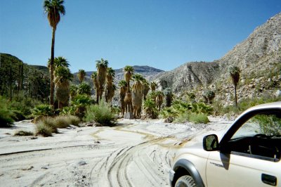
Petroglyphs at end of bulldozed road, edge of Santa Maria Canyon.
Red Diamondback came to us!

Heading up the Widow Maker on the way back to Santa Ynez!

[Edited on 11-4-2005 by David K]
|
|
|
David K
Honored Nomad
        
Posts: 65411
Registered: 8-30-2002
Location: San Diego County
Member Is Offline
Mood: Have Baja Fever
|
|
| Quote: | Originally posted by TW
Check out the Turquesa digs and water pools just north of Las Arrastras before Coco's Corner, this is also a short cut for bikes from hwy 1 if your an
excellent rider. Say high to Coco and if you can, take him some 7up. I think it was Corky that told me he likes 7up. Also if you have time look for
the old trail road to the mission from hwy 1 near KM187 at San Ignacito, either from the hwy side or the mission side. I've looked for it but never
found it. It may not be passable in a 4 wheeler. |
I have a web page for La Turquesa Canyon, just 3 mi. north of Las Arrastras: http://vivabaja.com/wayno
Here's part of a map showing the pools and turquoise mine...
|
|
|
David K
Honored Nomad
        
Posts: 65411
Registered: 8-30-2002
Location: San Diego County
Member Is Offline
Mood: Have Baja Fever
|
|
El Volcan
From my '403' (April 2003) web page:
On to El Volcan...
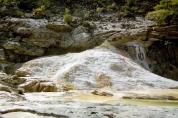
Four miles northeast of the El Marmol onyx schoolhouse, the process by which onyx is made can be seen, at El Volcan. Several mineral springs where
onyx is created (about an inch every thousand years) are in the arroyo and a quarter mile beyond. The biggest spring is on top of a thirty foot dome,
which erupts once a month. This cold water geyser is how El Volcan (The Volcano) got its name. For several minutes water and gas is sprayed 60 feet
into the sky!
Directions:
Take the signed dirt road off Highway 1 for 9.5 miles to El Marmol's onyx schoolhouse. Note sign pointing to the Mina La Olividada road. At 2.0 miles
from the schoolhouse, turn right, 4WD recommended from here. At 4.0 miles, come to Arroyo El Volcan. Onyx dome is 0.4 mile to right, up arroyo. Ahead,
at 4.3 miles, the La Olividada road passes a white slope with several onyx springs.
If you cross the arroyo on the road, a 1/4 mile beyond is this:

If you turn up the arroyo (right), and continue on foot:
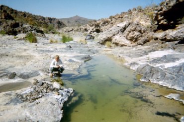

You come to this...
The El Volcan Onyx Dome 29?59.54'/ 114?46.22'
|
|
|

