schwlind
Nomad

Posts: 362
Registered: 8-30-2008
Location: Daytona Beach, FL/San Antonio Del Mar (Colonet)
Member Is Offline
|
|
Does Hwy 1 between TJ and San Quintin go above 3,000?
Does Hwy 1 (including the toll road) between TJ and San Quintin go above 3,000 feet? Does anyone have this information or know where it can be found?
A friend, who had a detached retina that recently miraculously reattached itself has been advised by her eye doc that not only can she not fly for
some period of time, but said that she should not be above 3,000 feet. Since she was planning to go to Baja over the Holidays, she doesn't want to
risk going through the mountains south of TJ and Ensenada to San Antonio Del Mar if there is a risk.
Any info or guidance would be greatly appreciated...
Linda
|
|
|
fdt
Ultra Nomad
Posts: 4059
Registered: 9-7-2003
Location: Tijuana, Baja California
Member Is Offline
Mood: Yeah, what if it all goes right
|
|
La Rumorosa is the highest point of any hwy in Baja California at about 4000 feet and that is going east to Mexicali. On Hwy 1 I would think the
highest would be Cataviña at about 2000 feet.
A well informed Baja California traveler is a smart Baja California traveler!
|
|
|
BornFisher
Super Nomad
Posts: 2134
Registered: 1-11-2005
Location: K-38 Santa Martha/Encinitas
Member Is Offline
|
|
I doubt there is anywhere between TJ and SQ that is even close to 3,000 ft. The question is can she travel to TJ without going over 3.000ft. Where is
she traveling from?
|
|
|
schwlind
Nomad
Posts: 362
Registered: 8-30-2008
Location: Daytona Beach, FL/San Antonio Del Mar (Colonet)
Member Is Offline
|
|
Traveling from LA
[Edited on 12-17-2008 by schwlind]
|
|
|
David K
Honored Nomad
Posts: 65551
Registered: 8-30-2002
Location: San Diego County
Member Is Offline
Mood: Have Baja Fever
|
|
| Quote: | Originally posted by schwlind
Does Hwy 1 (including the toll road) between TJ and San Quintin go above 3,000 feet? Does anyone have this information or know where it can be found?
A friend, who had a detached retina that recently miraculously reattached itself has been advised by her eye doc that not only can she not fly for
some period of time, but said that she should not be above 3,000 feet. Since she was planning to go to Baja over the Holidays, she doesn't want to
risk going through the mountains south of TJ and Ensenada to San Antonio Del Mar if there is a risk.
Any info or guidance would be greatly appreciated...
Linda |
No, according to the topo map, the highest point is between Santo Tomas and San Vicente... and that looks to be near 1,500'.
|
|
|
longlegsinlapaz
Super Nomad
Posts: 1685
Registered: 11-18-2005
Location: La Paz
Member Is Offline
|
|
Have her log onto Google Earth & scroll down the hwy from LA to however far she wants to travel...Google Earth shows elevations for where ever the
cursor is pointing along the bottom center of the screen just to the right of the coordinates.
|
|
|
schwlind
Nomad
Posts: 362
Registered: 8-30-2008
Location: Daytona Beach, FL/San Antonio Del Mar (Colonet)
Member Is Offline
|
|
Great information... thanks everyone for your kind and prompt responses...
Linda
|
|
|
David K
Honored Nomad
Posts: 65551
Registered: 8-30-2002
Location: San Diego County
Member Is Offline
Mood: Have Baja Fever
|
|
Topo map of highest area...
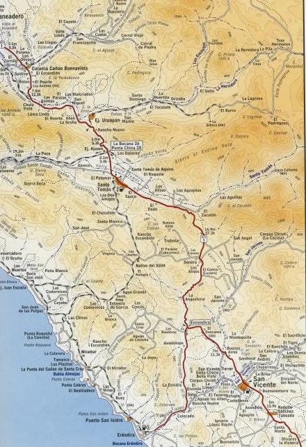
Not easy to make out when sized for Nomad... but the highway touches the 500 meter contour line between Santo Tomas and San Vicente... and that's the
highest point south of Tijuana until you get to the Aguajito grade area past El Rosario... well south of San Quintin.
The Google Earth idea is a great one!!!
[Edited on 12-18-2008 by David K]
|
|
|
David K
Honored Nomad
Posts: 65551
Registered: 8-30-2002
Location: San Diego County
Member Is Offline
Mood: Have Baja Fever
|
|
I dragged my mouse on Google Earth along the highway... and the highest point is the south grade out of Santo Tomas, and the highest point was under
1,600' (1,598').
|
|
|
TonyC
Nomad
Posts: 421
Registered: 1-25-2008
Member Is Offline
|
|
No. Used my gps, never went over 2000ft.
|
|
|
schwlind
Nomad
Posts: 362
Registered: 8-30-2008
Location: Daytona Beach, FL/San Antonio Del Mar (Colonet)
Member Is Offline
|
|
Thanks to all of you who have been so very helpful with this information. My friend in LA is grateful as well.
Hope everyone has a wonderful Christmas (or Holiday Season) and a great 2009!
Thank you again and stay safe in your travels!
Linda
[Edited on 12-18-2008 by schwlind]
|
|
|