David K
Honored Nomad
        
Posts: 65436
Registered: 8-30-2002
Location: San Diego County
Member Is Offline
Mood: Have Baja Fever
|
|
SAN FRANCISQUITO shortcut to Hwy. 1 (El Arco bi-pass)
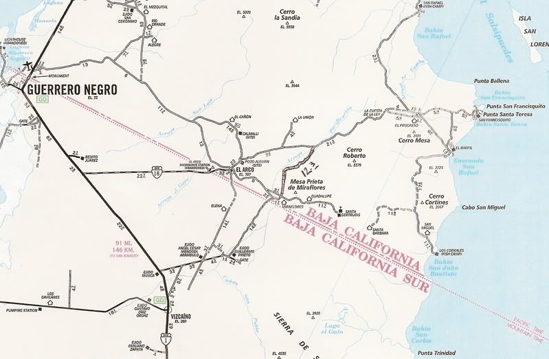
I got a request to post these maps showing the road from just north of Vizcaino to Guillermo Prieto north to the El Arco/ San Francisquito road... The
newest AAA (2007) map only has the southern half of it showing (Guillermo Prieta to the Santa Gertrudis road)... but it continues right across... as I
show in the maps below... when I traveled it on Dec. 31, 2001.

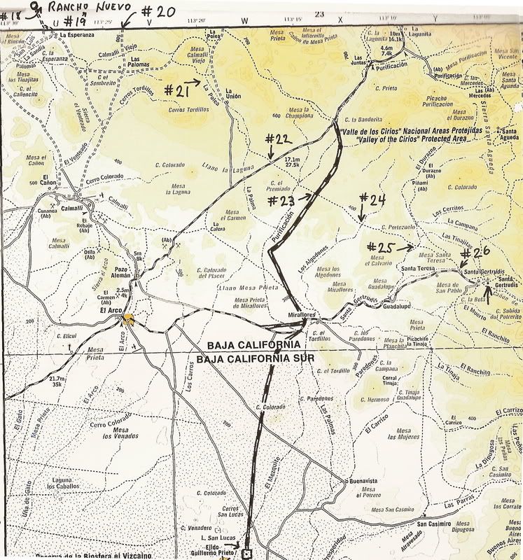
This topo map was used to show the photo locations on my El Camino Real from space article (arrows with numbers):

[Edited on 2-5-2009 by David K]

|
|
|
David K
Honored Nomad
        
Posts: 65436
Registered: 8-30-2002
Location: San Diego County
Member Is Offline
Mood: Have Baja Fever
|
|
The road is very easy to follow on Google Earth... It was very smooth and an easy 2WD graded road back when I used it... and haven't heard of any
problems. Please comment if you have more recent reports... The Baja 1000 a couple years ago did use it, so it may have been damaged.
The GPS data for the route is on my GPS waypoints web page at VivaBaja.com. It goes over one large hill, otherwise it is flat driving... It was a MUCH
better route to Hwy. 1 than going through El Arco! Also, it is a good shortcut for travelers heading south or coming north from San Ignacio.
The turnoff had signs for Santa Gertrudis mission at both ends, back then. The mission is a worthy side trip off this road, as well!
GPS data (set unit to Map Datum 'NAD27 Mexico'):
North to south:
Fork, ahead/west for El Arco, turn left/south for new road to Hwy.1: 28°10.42'/ 113°13.08'
Crossroad, south to state border and Hwy.1, east to Mision Sta. Gertrudis (& next 3 waypoints): 28°01.45'/ 113°14.45'
... Rancho Miraflores: 28°01.45'/ 113°13.76'
... Rancho Guadalupe: 28°02.36'/ 113°09.33'
... Mision Santa Gertrudis: 28°03.95'/ 113°05.05'
State Border, Mountain Time Zone: 28°00.00'/ 113°16.16'
Guillermo Prieto: 27°50.62'/ 113°17.84'
'T' Jcn., turn west: 27°49.97'/ 113°17.94'
Hwy. 1 Jcn. (south-east to Vizcaino): 27°43.41'/ 113°27.23'
[Edited on 2-5-2009 by David K]
|
|
|
Phil C
Senior Nomad
  
Posts: 566
Registered: 3-27-2004
Location: N. San Diego County/ Loreto Centro/Lopez Mateos
Member Is Offline
|
|
David, we used this rout at Christmas time ,thanks to your suggestion, and found it in great shape. We went from north to south with a side trip to
Santa Gertrudis. Although we did use 4 wheel drive in a couple of spots, I think a 2 wheel drive vehicle would make it.
|
|
|
Santiago
Ultra Nomad
    
Posts: 3541
Registered: 8-27-2003
Member Is Offline
|
|
Went South to North in January and found the road easy w/ pickup, never use 4X4. A little rocky in spots but mostly sandy soil. Going north from
Vizcaino, it is very easy to miss the turn off at Ej. Guillermo and continue east. As soon as you see the houses/buildings, turn north. At about #23
on DK's map is a great cardon forest. Plan on at least a 30 minute stop to walk around. The weirdest thing is we had a 2-bar cell signal there but
it was a funny ID name of the carrier. We had just passed a ranchero with a radio tower and I wonder if they had a small cell site for local
communication? Anyone else notice this? By the way, the ranchero has gas and groceries for sell per their sign (we did not stop in). Also,
traveling north, the road "T's" at El Progresso. There is no signage (duh), but right (east) is to San Francisquito and left (west) is on to Poncho's
(San Rafael Beach Camp on the first map) and BOLA. Doesn't feel right but that's it.
I think BajaBoy's got this covered, but anyone stopping by Poncho's - take him a corkscrew. Dude's trying to use an icepick for his evening's Merlot.
This trip is do-able on any medium-high clearance vehicle - some sandy spots north of the ejido with deep ruts - a low car might scrape the sand.
Plan on about 6 hours from Vizcaino to BOLA if you're taking it easy. There are no bathrooms.
Does essence predate existence?
|
|
|
David K
Honored Nomad
        
Posts: 65436
Registered: 8-30-2002
Location: San Diego County
Member Is Offline
Mood: Have Baja Fever
|
|
Thanks for the updates guys...
Yes, the sharp left turn (northbound) into Guillermo Prieto could be passed if there is no sign. A small 'Mision Santa Gertrudis' sign was there in
2001... You drive straight through the dusty village.
|
|
|
Bob H
Elite Nomad
     
Posts: 5867
Registered: 8-19-2003
Location: San Diego
Member Is Offline
|
|
David, this is GREAT! Thanks.
Bob H
|
|
|
Mexitron
Ultra Nomad
    
Posts: 3397
Registered: 9-21-2003
Location: Fort Worth, Texas
Member Is Offline
Mood: Happy!
|
|
Calmalli is an interesting stop on the way--poke around the remains of the once bustling mining town....
|
|
|
Vanderpooch
Junior Nomad

Posts: 25
Registered: 11-17-2009
Member Is Offline
|
|
Update bump :D
Bump for updates?
Heading there this january!
|
|
|
KasloKid
Nomad
 
Posts: 327
Registered: 8-29-2009
Member Is Offline
|
|
GPS map for el arco bypass
I noticed that this bypass is noted on a mexican topo map called e32. Web site: http://www.cartografiagps.com/index2.htm
This isn't a plug for the website, only making a note that this is the only garmin mapping program that shows this road. I took the road that heads
directly south from el arco... it was a narrow two lane deep sand road. I was using bicimapas map. Should have taken the baja almanac with me :-)
|
|
|
David K
Honored Nomad
        
Posts: 65436
Registered: 8-30-2002
Location: San Diego County
Member Is Offline
Mood: Have Baja Fever
|
|
The road that heads south from El Arco was the main transpeninsular road before Highway 1 was built in 1973, bypassing old El Arco to head close to
the newer, growing town of Guerrero Negro. They did pave a road into El Arco* from the new highway, but so thin was the asphalt it was mostly gone
within about 10 years.
*Mexico Federal Highway #18   
[Edited on 9-8-2010 by David K]
|
|
|
SoCalAl
Nomad
 
Posts: 156
Registered: 6-8-2004
Location: Punta Banda, Ca
Member Is Offline
Mood: Hungry
|
|
Great Info Dave, thanks....
Ahh Baja.... Where you can hear yourself think & commingling with the locals will humble you.
|
|
|
David K
Honored Nomad
        
Posts: 65436
Registered: 8-30-2002
Location: San Diego County
Member Is Offline
Mood: Have Baja Fever
|
|
| Quote: | Originally posted by Santiago
Went South to North in January and found the road easy w/ pickup, never use 4X4. A little rocky in spots but mostly sandy soil. Going north from
Vizcaino, it is very easy to miss the turn off at Ej. Guillermo and continue east. As soon as you see the houses/buildings, turn north. At about #23
on DK's map is a great cardon forest. Plan on at least a 30 minute stop to walk around. The weirdest thing is we had a 2-bar cell signal there but
it was a funny ID name of the carrier. We had just passed a ranchero with a radio tower and I wonder if they had a small cell site for local
communication? Anyone else notice this? By the way, the ranchero has gas and groceries for sell per their sign (we did not stop in). Also,
traveling north, the road "T's" at El Progresso. There is no signage (duh), but right (east) is to San Francisquito and left (west) is on to Poncho's
(San Rafael Beach Camp on the first map) and BOLA. Doesn't feel right but that's it.
I think BajaBoy's got this covered, but anyone stopping by Poncho's - take him a corkscrew. Dude's trying to use an icepick for his evening's Merlot.
This trip is do-able on any medium-high clearance vehicle - some sandy spots north of the ejido with deep ruts - a low car might scrape the sand.
Plan on about 6 hours from Vizcaino to BOLA if you're taking it easy. There are no bathrooms. |
That #23 on the map (and the other numbers) are points where you can see the Jesuit El Camino Real mission road from the 1700's on Google Earth (and
in person, of course).
Read Harry Crosby's 'The King's Highway in Baja California' c1974. As well as the link to Harry Crosby's maps and photos on my website VivaBaja.com. I
also have the entire Jesuit El Camino Real mapped and imaged here on Baja Nomad.
|
|
|

