David K
Honored Nomad
        
Posts: 65407
Registered: 8-30-2002
Location: San Diego County
Member Is Online
Mood: Have Baja Fever
|
|
Many of Baja's Spanish missions were moved!
... sometime following their founding. From a few months to many years later, missions were moved for various reasons, but lack of sufficient water
was often the case. At least 13 missions were relocated at least once.
A mission would often be established near a large native Indian population. The water source may have been enough for the Indians, but the padres
converted the hunter/ gatherer method used to get food, to agriculture... which required more water than people alone needed.
The SECOND California mission (SAN JAVIER) was the first mission to be moved... The following list is from my NEW Baja Missions and Visitas web site
http://vivabaja.com/bajamissions
[The number before the nameis the mission number following Loreto (which is #1). If two listings of the same number (with a & b added), the
mission also changed its name with the move.]
2) San Francisco Javier de Biaundo 1699-1817 (moved 5 miles south in 1710)
5) San Jose de Comondu 1708-1827 (moved 22 miles south in 1736
6) La Purisima Concepcion de Cadegomo 1720-1822 (moved 10 miles south in 1735)
7a) Nuestra Seņora del Pilar de la Paz Airapi 1720-1748 (moved to Todos Santos in 1748)
7b) Nuestra Seņora del Pilar de la Paz (Todos Santos) 1748-1840
9a) Nuestra Seņora de los Dolores Apate 1721-1741 (moved to La Pasion in 1741)
9b) Nuestra Seņora de los Dolores Chilla (La Pasion) 1741-1768
10) Santiago el Apostal Aiņini 1724-1795 (moved 2 miles south in 1734)
12) San Jose del Cabo Aņuiti 1730-1840 (moved 5 miles north from the coast, then back to the coast, then 1 mile north where today's town plaza and
church are located)
17a) Calamajue 1766-1767 (moved 30 miles north in 1767)
17b) Santa Maria de los Angeles 1767-1769
19) Nuestra Seņora del Rosario Viņaraco 1774-1832 (Moved 2 miles west in 1802)
20) Santo Domingo 1775-1839 (Moved 2 miles east in 1793)
22) San Miguel Arcangel 1787-1834 (moved 7 miles west in 1788)
23) Santo Tomas de Aquino 1791-1849 (moved 1 mile northeast in 1794, and 2 miles east in 1799)
24) San Pedro Martir de Verona 1794-1806 (moved 7 miles south and nearly 2,000' lower in elevation, after 3 months)
26) El Descanso 1817-1834 (Also called 'San Miguel Nuevo', moved 1/2 mile north in 1830)
See photos, maps and details on the mission web pages...
[Edited on 9-29-2009 by David K]
|
|
|
David K
Honored Nomad
        
Posts: 65407
Registered: 8-30-2002
Location: San Diego County
Member Is Online
Mood: Have Baja Fever
|
|
Some notes:
Mission #7b was usually called 'Todos Santos' which was the name of the visita of the La Paz mission (on La Paz Bay) before it became a seperate
mission of 'Santa Rosa de las Palmas'... When the La Paz mission moved to Todos Santos/ Santa Rosa... It took over, and Santa Rosa ended.
Mission #9 (a & b) is also known as Dolores del Sur, perhaps because there was a proposed mission of Dolores del Norte for a time that would be
renamed Santa Gertrudis when built. When Dolores moved to the visita of La Pasion, the visita name would often be used for the new location.
|
|
|
David K
Honored Nomad
        
Posts: 65407
Registered: 8-30-2002
Location: San Diego County
Member Is Online
Mood: Have Baja Fever
|
|
Santiago
I almost forgot Santiago (the mission, not the Nomad)! Added to the list above...
Santiago is one of the missions with some mystery and confusing history connected to it...
When the Jesuits were ready to establish a mission in the Cape region a year after founding the mission at La Paz, they chose the shores of Bahia las
Palmas (near today's Los Barriles). Before the end of 1721, the effort was abandoned. Some books will name a mission of 'Ensenada de las Palmas' for
this failed effort.
In 1722, a second mission attempt was made twenty miles west of Los Barriles, at 'Santa Ana'. That too was abandoned following the collapse of the
church during a storm, which killed many Indians. Santa Ana would soon become the first important mine in California with the discovery of silver,
there... known as 'Real de Santa Ana'.
In 1724, the third attempt at a new location, was a success. About two miles north of today's Santiago, the mission was founded and remained for ten
years. Some foundation stones remain today on a private ranch of this site.
In 1734, the Santiago mission was moved to the site now occupied by the town church. Another move in 1790 to Cadueņo is reported by some historians.
No ruins there have been found, however. The mission was closed for good in 1795 and remaining Indians transfered to the mission of San Jose del Cabo.
|
|
|
David K
Honored Nomad
        
Posts: 65407
Registered: 8-30-2002
Location: San Diego County
Member Is Online
Mood: Have Baja Fever
|
|
Maps of three moved missions
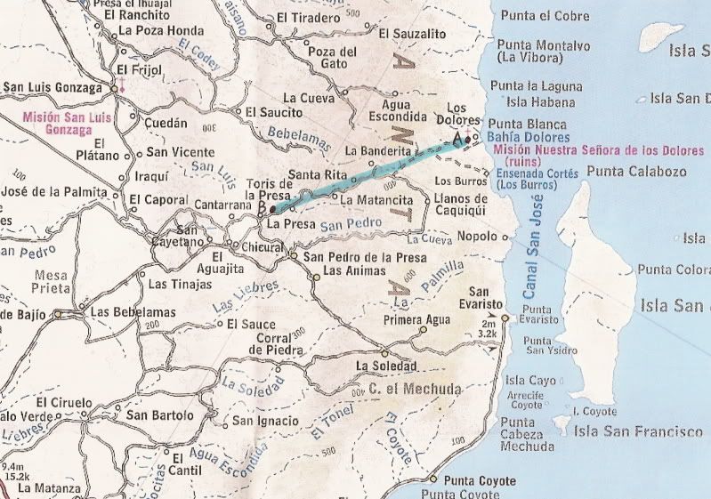
Map 1) Shows the two main locations for Mision Los Dolores and the move from 'A' Apate (near the coast) to 'B' Chilla at 'La Pasion' (near Rancho La
Presa)...

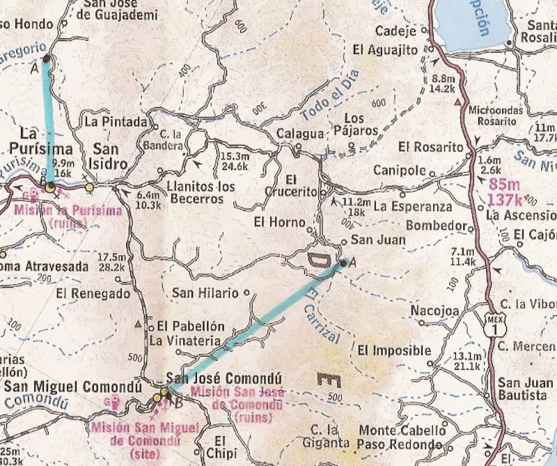
Map 2) Shows two moved missions...
San Jose de Comondu from 'A' (near Rancho San Juan) to 'B' (today's town of San Jose Comondu).
La Purisima Concepcion de Cadegomo from 'A' (near Paso Hondo) to 'B' (today's town of La Purisima).

|
|
|
David K
Honored Nomad
        
Posts: 65407
Registered: 8-30-2002
Location: San Diego County
Member Is Online
Mood: Have Baja Fever
|
|
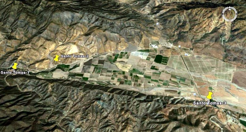
The three sites for the Santo Tomas mission as shown on a satellite map.

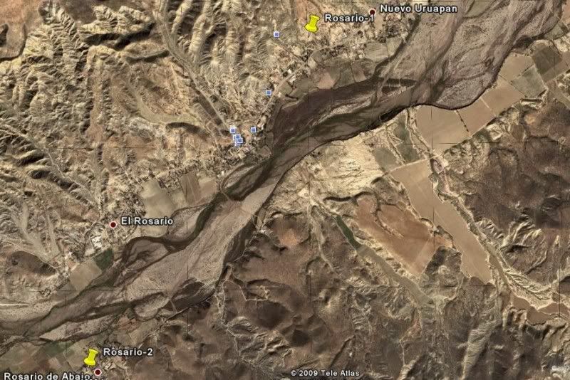
The two sites for El Rosario mission...

Satellite maps of most of he mission sites now here: http://vivabaja.com/missions4
ENJOY!
|
|
|
David K
Honored Nomad
        
Posts: 65407
Registered: 8-30-2002
Location: San Diego County
Member Is Online
Mood: Have Baja Fever
|
|
The story is in the details... Nomads got a preview in 2009 of the data that would be incorporated into the book I helped with a couple years after!
|
|
|
|

