John M
Super Nomad
   
Posts: 1924
Registered: 9-3-2003
Location: California High Desert
Member Is Offline
|
|
Lost Mission Dolores???
In a new book authored by Robert S. Wood, is an interesting chapter on the lost mission Dolores and it's "locator" Murl Emery.
I haven't checked Erle Gardner's books to see any reference but this chapter was written by Wood, also on this Gardner expedition.
If I tell too much, the mission will not still be "lost!" plus Wood has a wonderful story to tell.
There are several other Baja chapters in the book.
The book:
Desert Riverman, The Free-spirited Adventures of Murl Emery
Fretwater Press
1000 Grand Canyon Avenue
Flagstaff, Arizona 86001
www.fretwater.com
|
|
|
David K
Honored Nomad
        
Posts: 65407
Registered: 8-30-2002
Location: San Diego County
Member Is Offline
Mood: Have Baja Fever
|
|
I have addressed the 'lost' Dolores del Norte mission story pretty well... It is a funny story and The Erle Stanley Gardner group was even told by the
villagers of San Francisco de la Sierra that the walls up there were the remains of 'Dolores'!
See http://vivabaja.com/bajamissions and see Santa Gertrudis and the Visita of San Pablo for more on 'Dolores del Norte'.
Naturally, these details were not available to the authors of earlier books and maps!
Thanks John for posting!!
[Edited on 3-2-2013 by David K]
|
|
|
David K
Honored Nomad
        
Posts: 65407
Registered: 8-30-2002
Location: San Diego County
Member Is Offline
Mood: Have Baja Fever
|
|
I tried the link to the publisher a few times and it seems to have issues... however, I did a bing search of the author... and found his new book:


Desert Riverman
Introduction
This is a book about a man who all his life did exactly as he pleased---never mind the consequences. And what he pleased to do was roam the deserts of
the southwest, to see what he could see.
A man who spends his life exploring the desert may properly be called a prospector, for a prospector, very simply, is a man who looks. In a lifetime
of vigorous prospecting, Murl looked a lot and found a great deal. But like any true prospector, it was the looking he relished, not the finding.
The stories in this book are the ones Murl liked best to tell. No one, himself included, knew if all of them were strictly true. Probably not. After
all, he liked to brag about being an accomplished liar. And his daughter Jane says “Forget it. He had a vivid and fertile imagination.”
But I can testify to the general authenticity and credibility of his tales on the basis of the half dozen adventures I shared with Murl in the deserts
of the southwest and Mexico and on the Colorado River.
More important by far than the details of Murl’s adventures is the delightful, tireless childlike curiosity he brought to them. This and an unending
gruff but gentle sense of humor produced success as a human being that few have managed to achieve.
Murl enjoyed a rare freedom and happiness that can only derive from following his heart and living exactly as he pleased---thanks in part to his
devoted wife, Edith, who made his enviable life possible---and who he took good care of.
He was as happy a man as I’ve known and it was a pleasure to be with him. Remembering our times together as I prepared this book for publication, I
found I still missed the old rascal.
Bob Wood, Sedona, AZ - April, 2009
|
|
|
David K
Honored Nomad
        
Posts: 65407
Registered: 8-30-2002
Location: San Diego County
Member Is Offline
Mood: Have Baja Fever
|
|
Hi John... I got the book and have started enjoying it... there are at least three chapters on Baja when Murl traveled with the Erle Stanley Gardner
expeditions...
Like me, Murl loved finding the Camino Real as it crossed the desert and mountains between missions... and believing there was still a missing (or
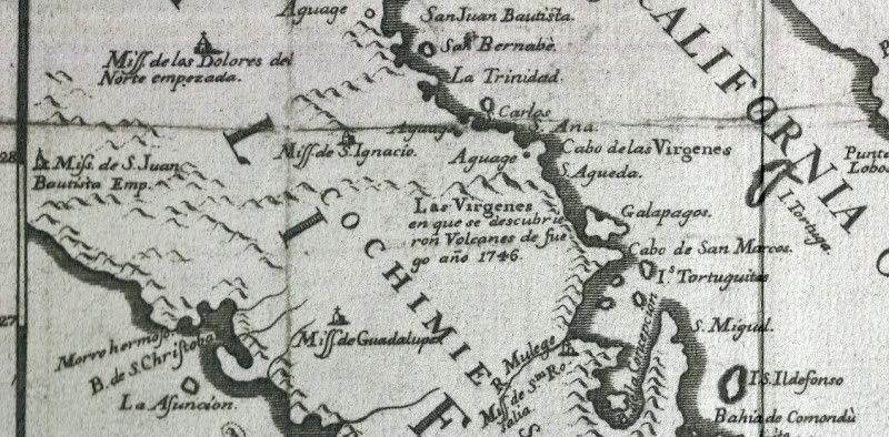
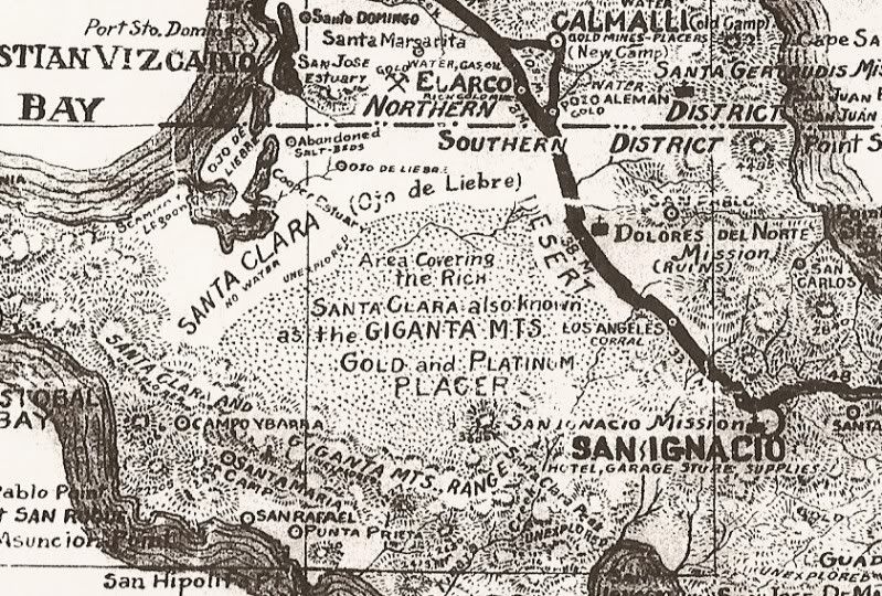
lost) mission called 'Dolores de Norte' (as shown on maps from 1757 to presnt time). Lost mission hunting is a great Baja activity!
What was most pleasing to read was another published connection between 'Dolores del Norte' and the mountain village of San Francisco de la Sierra.
Choral Pepper was the first to publish the story of when she arrived at tiny San Francisco by helicopter in the 1960's with the Gardner party. When
she asked the women of the village about the old walls up there, their reply was "Dolores".
The raw truth of the matter is that there never was an actual mission established called 'Dolores del Norte'. It was a propsed name for the next
mission to be founded, north of San Ignacio. The name appeared on the 1757 Jesuit map (along with two other 'lost missions')... http://vivabaja.com/1757 and http://vivabaja.com/109 at one of the other sites, perhaps.
When funds were provided for the Dolores del Norte project, the benefactor requested the new mission be named Santa Gertrudis... and so it was. One of
the visitas (mission visiting stations) for Santa Gertrudis is located in San Pablo Canyon, below San Francisco de la Sierra... and it is so
impressive a ruin that travelers of the first half of the 1900's believed it was a lost mission and labled it 'Dolores del Norte'... Even INAH calls
the San Pablo ruins Dolores del Norte! See photos of San Pablo: http://vivabaja.com/missions3/page7.html
The people of San Francisco de la Sierra in the 1960's probably believed that the ruins up there were the Dolores mission. It may have been an early
site for a mission, but the lack of water for farming would have prevented it from being more than a small visita or mission ranch.
Harry Crosby has a lot of details of the family clans of the Baja mountains where the Arces and Villavicencios (and others) have prospered over the
past 250 years and still live today as did their ancestors. Harry Crosby's 'The Last of the Californios' c1981 is an excellent source of history of
the mountain people of Baja California.
1757 map, close up...

1941 map, close up...

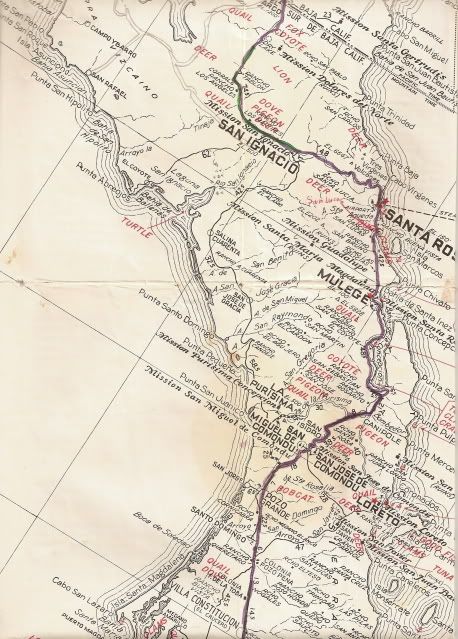
1963 map...


|
|
|
BajaBlanca
Select Nomad
      
Posts: 13242
Registered: 10-28-2008
Location: La Bocana, BCS
Member Is Offline
|
|
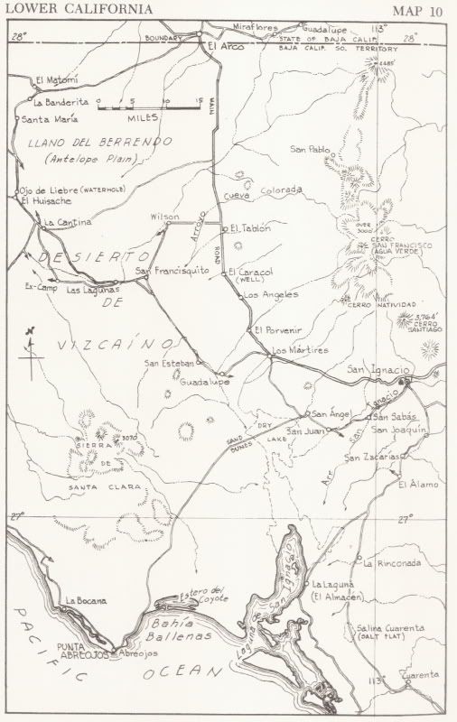
it amazes me that these maps do not even show la bocana on them .... we are right next to abreojos, only 10 miles north .... none of the old maps list
la bocana. The road used to be so rough, that it took Les FOUR hours by car from highway 1.
it is local lore that Dr Romero, who was a sub-delegado here and is now our resident doc, went to the Capital (DF) and argued that la bocana should be
added to maps. So, I have been told by locals that HE PUT LA BOCANA ON THE MAP.
|
|
|
David K
Honored Nomad
        
Posts: 65407
Registered: 8-30-2002
Location: San Diego County
Member Is Offline
Mood: Have Baja Fever
|
|
| Quote: | Originally posted by BajaBlanca
it amazes me that these maps do not even show la bocana on them .... we are right next to abreojos, only 10 miles north .... none of the old maps list
la bocana. The road used to be so rough, that it took Les FOUR hours by car from highway 1.
it is local lore that Dr Romero, who was a sub-delegado here and is now our resident doc, went to the Capital (DF) and argued that la bocana should be
added to maps. So, I have been told by locals that HE PUT LA BOCANA ON THE MAP. |
In 1962:

|
|
|
David K
Honored Nomad
        
Posts: 65407
Registered: 8-30-2002
Location: San Diego County
Member Is Offline
Mood: Have Baja Fever
|
|
Blanca, any idea when the first full time resident statred living at La Bocana? In 1962, the Lower California Guidebook lists La Bocana as "usually
unihabited" (p. 140).
Antonio's father (Baja Cactus) was in charge of the first school there. When he arrived after many dusty miles from civilization he discovered the
school he was put in charge of had nobody else working there... and met Antonio's mother when she was sent to be the first assistant to the new
school's only teacher/ principal.
|
|
|
David K
Honored Nomad
        
Posts: 65407
Registered: 8-30-2002
Location: San Diego County
Member Is Offline
Mood: Have Baja Fever
|
|
Blanca?
|
|
|
|

