TMW
Select Nomad

Posts: 10659
Registered: 9-1-2003
Location: Bakersfield, CA
Member Is Offline
|
|
Mikes Sky Ranch Roads
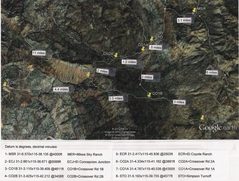
Here is a drawing on Google Earth I did with some update mileages from last weekend. At the top right is Mikes Sky Ranch and access to hwy 3 at
KM137/138. The lower right is the junction to El Concepcion and access to the Observatory road at KM67/68. However the owner would prefer off roaders
take a different route. If you would like to stay at his B&B and look at the stars or just relax you can contact him with the info onhis website
at http://bajadarkskies.com.
I went from Mikes Sky Ranch out to El Coyote last weekend by way of CO2A thru CO2B on the map. There are a couple of difficult spots but no big deal.
Coming from El Coyote I'd recommend going from ECR to CO2A because of one of those difficult spots, maybve after more traffic it will be OK in that
direction. Also this direction has a gate near CO2A so make sure you close it.
|
|
|
David K
Honored Nomad
Posts: 65563
Registered: 8-30-2002
Location: San Diego County
Member Is Offline
Mood: Have Baja Fever
|
|
You are getting real good at this TW!
|
|
|
TMW
Select Nomad
Posts: 10659
Registered: 9-1-2003
Location: Bakersfield, CA
Member Is Offline
|
|
We need to get Ken and his Jeep compadres to do a road repair trip. We need to check out all the roads shown and fix them as needed so people can move
and explore the great unknown. My next trip to Mikes Sky Ranch will be to make a circle around the outer ring and crossover road CO1A to CO1B.
|
|
|
Ken Cooke
Elite Nomad
Posts: 8971
Registered: 2-9-2004
Location: Riverside, CA
Member Is Offline
Mood: Pole Line Road postponed due to injury
|
|
| Quote: | Originally posted by TW
We need to get Ken and his Jeep compadres to do a road repair trip. We need to check out all the roads shown and fix them as needed so people can move
and explore the great unknown. My next trip to Mikes Sky Ranch will be to make a circle around the outer ring and crossover road CO1A to CO1B.
|
I smell an adventure brewing! This would be my first trip to the Sierra San Pedro Martir region since 2001.
|
|
|
Tree
Newbie
Posts: 16
Registered: 2-20-2012
Member Is Offline
|
|
I'm planning a Bike/jeep trip into Mike from the observatory road (previous post). I'm coming from San Quitin and I want to do as much dirt as
possible. I was wondering about a dirt road that shows on my baja atlas that cuts in off MEX 1 about half way between vincente Guerrero and Camalu. It
heads east then cuts north and ends up at observatory road. It goes by aguaje del burro and el carricito according to my atlas. Any info on this road?
passable? gates? etc.
|
|
|
David K
Honored Nomad
Posts: 65563
Registered: 8-30-2002
Location: San Diego County
Member Is Offline
Mood: Have Baja Fever
|
|
Have not heard anything, and for Nomads to picture the road in their minds:
El Carricito is close to the road between San Telmo Valley and Valladares and Santa Cruz... parralel to the Observatory highway (to Meling Ranch from
San Telmo), to the south.
Then...
Santa Cruz north to El Potrero to the Observatory highway.
|
|
|
TMW
Select Nomad
Posts: 10659
Registered: 9-1-2003
Location: Bakersfield, CA
Member Is Offline
|
|
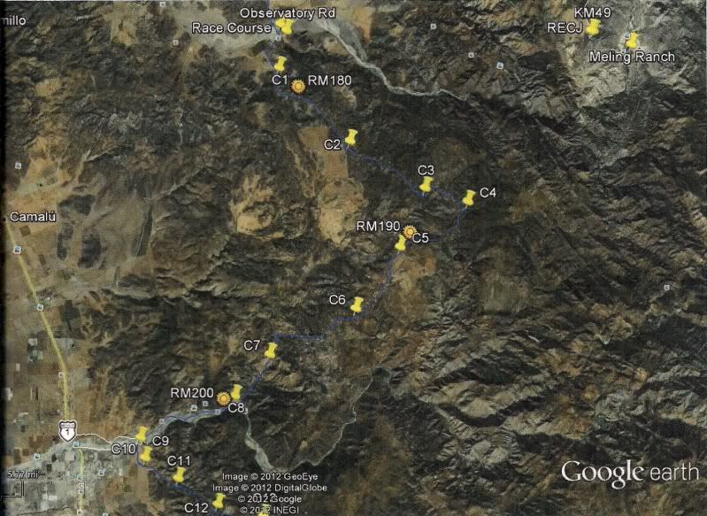
You can take the arroyo road north side in Santo Domingo east and follow the SCORE 2007 Baja 1000 course backwards to the Observatory road. Here is a
Google Earth overlay of the course with markers.
|
|
|
David K
Honored Nomad
Posts: 65563
Registered: 8-30-2002
Location: San Diego County
Member Is Offline
Mood: Have Baja Fever
|
|
Great map... it looks like C4 is where it joins the Valladares road... and he could go east to Santa Cruz then up past El Potrero to the Observatory
hwy. from there... ?
|
|
|
TMW
Select Nomad
Posts: 10659
Registered: 9-1-2003
Location: Bakersfield, CA
Member Is Offline
|
|
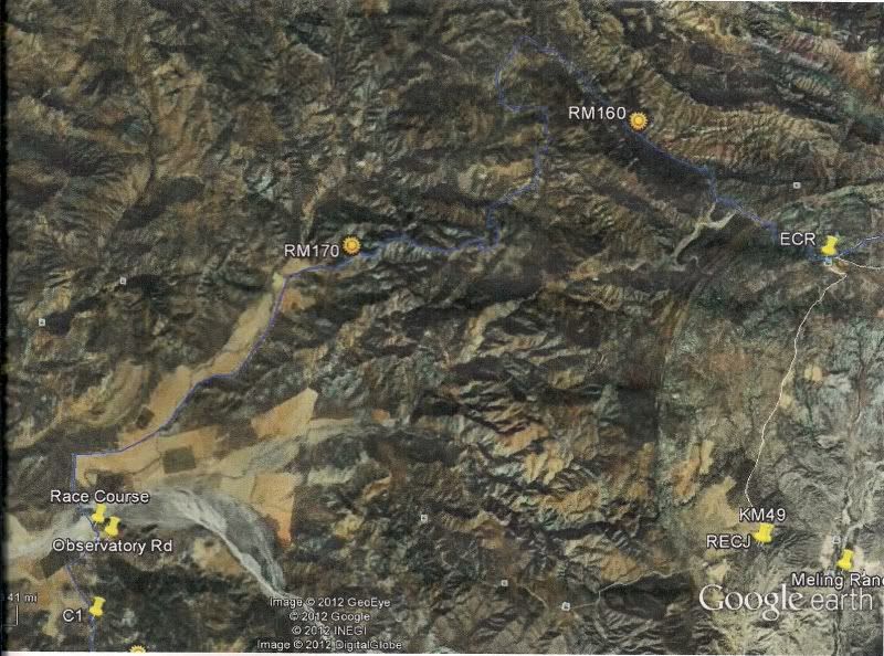
Here is the GE B1K from the top of the picture above to El Coyote Ranch.
Tree you can follow the blue course lines here and match it with Google Earth for a closer view of the trail.
I preran this part of the course in 2007 and have not been on it since but I believe they are used often by the locals. Rule of thumb is if a gate is
not locked and does not say keep out or private property you can go thru but make sure you close it behind you so the cattle don't get out.
|
|
|
TMW
Select Nomad
Posts: 10659
Registered: 9-1-2003
Location: Bakersfield, CA
Member Is Offline
|
|
Also where the course comes to the Observatory Rd to where it gets off in the lower left is only about 1/4 mile give or take.
|
|
|
Barry A.
Select Nomad
Posts: 10007
Registered: 11-30-2003
Location: Redding, Northern CA
Member Is Offline
Mood: optimistic
|
|
My crazy Mom and Aunt (sisters) who 4-wheeled all over Baja from the early '50's thru the late '80's always said about "no trespassing" signs that if
they did not include the word "positively" then it was ok to go on thru, and then close the gate (leaving it the way you found it)--------but it was
best to stop by the ranch house and say howdy if you saw one.
No private land owner ever had an issue with this policy, they told me. The "no trespassing" signs were intended for the jerks!!! so that they could
prosecute if they had too. (!?!?!?!?!?)
Interesting phylosophy, no? 
Barry
|
|
|
TMW
Select Nomad
Posts: 10659
Registered: 9-1-2003
Location: Bakersfield, CA
Member Is Offline
|
|
From El Coyote race mile (RM) 155 there are gates at the following locations.
RM155, RM166, RM174, RM187 metal, RM192, and RM194. This is from the race course notes.
|
|
|
TMW
Select Nomad
Posts: 10659
Registered: 9-1-2003
Location: Bakersfield, CA
Member Is Offline
|
|
Barry I think years ago that was true and in some cases even today. But a lot of new people are owners of property now that may feel different.
Personally I don't pass thru when I see a sign. If I was to see the owner near by I would ask if I could otherwise I'd find a different route.
|
|
|
Barry A.
Select Nomad
Posts: 10007
Registered: 11-30-2003
Location: Redding, Northern CA
Member Is Offline
Mood: optimistic
|
|
| Quote: | Originally posted by TW
Barry I think years ago that was true and in some cases even today. But a lot of new people are owners of property now that may feel different.
Personally I don't pass thru when I see a sign. If I was to see the owner near by I would ask if I could otherwise I'd find a different route.
|
I know what you mean, TW, and agree. I said my Mom and Aunt were crazy, but they got away with it back then. Times have changed. I just always
thought it was a funny phylosophy, even back then, so was just passing it along as a joke (sorta).
Still, it is sooooo frustrating to run into lock gates, or "no trespassing" signs, especially if you have driven many miles on a very bad road trying
to "get somewhere", or just exploring.
Sigh!!!!!!
Barry
|
|
|
Tree
Newbie
Posts: 16
Registered: 2-20-2012
Member Is Offline
|
|
| Quote: | Originally posted by TW
You can take the arroyo road north side in Santo Domingo east and follow the SCORE 2007 Baja 1000 course backwards to the Observatory road. Here is a
Google Earth overlay of the course with markers.
|
Yeah that looks exactly like the route that shows on the baja atlas. I have never used google earth yet. Can I get gps locations off it? just as way
points like where the pins are located? or where it cut's off hwy 1?
[Edited on 3-21-2012 by Tree]
|
|
|
David K
Honored Nomad
Posts: 65563
Registered: 8-30-2002
Location: San Diego County
Member Is Offline
Mood: Have Baja Fever
|
|
Yes, you just move your mouse and the GPS waypoint changes as you move the pointer. It uses map datum WGS84. The road you asked is north of the race
course, but joins it. The race course went by Mision Santo Domingo.
|
|
|
bajaponderosa
Junior Nomad
Posts: 93
Registered: 8-2-2009
Location: South of San Felipe Baja Mexico
Member Is Offline
Mood: Living and Loving The Baja Way
|
|
Tw
Do you have any offroad maps that can get you from San Felipe to Mikes sky ranch. Starting in the San Felipe area desert.
|
|
|
Tree
Newbie
Posts: 16
Registered: 2-20-2012
Member Is Offline
|
|
Thanks guys. I downloaded the google earth and based on your map I was able to make a GPS track following the old 2007 course. I also made an alt.
track which enters closer to camalu that looks to be all well used dirt farm roads in case we are too beat for the first option.
|
|
|
TMW
Select Nomad
Posts: 10659
Registered: 9-1-2003
Location: Bakersfield, CA
Member Is Offline
|
|
| Quote: | Originally posted by bajaponderosa
Tw
Do you have any offroad maps that can get you from San Felipe to Mikes sky ranch. Starting in the San Felipe area desert. |
The only way from San Felipe off road is across diablo dry lake to San Matias and take the turn off on hwy 3 at KM 137/138.
|
|
|
David K
Honored Nomad
Posts: 65563
Registered: 8-30-2002
Location: San Diego County
Member Is Offline
Mood: Have Baja Fever
|
|
| Quote: | Originally posted by TW
| Quote: | Originally posted by bajaponderosa
Tw
Do you have any offroad maps that can get you from San Felipe to Mikes sky ranch. Starting in the San Felipe area desert. |
The only way from San Felipe off road is across diablo dry lake to San Matias and take the turn off on hwy 3 at KM 137/138. |
Exactly... Diablo Mountain is between the two points and you have to go around it!
|
|
|


