Ken Cooke
Elite Nomad
     
Posts: 8970
Registered: 2-9-2004
Location: Riverside, CA
Member Is Offline
Mood: Pole Line Road postponed due to injury
|
|
Tijuana, Mexico -- Tia Juana, California (undated)
When was there ever a "Tia-Juana, California"??

|
|
|
bajaguy
Elite Nomad
     
Posts: 9247
Registered: 9-16-2003
Location: Carson City, NV/Ensenada - Baja Country Club
Member Is Offline
Mood: must be 5 O'clock somewhere in Baja
|
|
Tia Juana, California
http://www.digthatcrazyfarout.com/oldtj/TJ_history.htm
The City
"Tia Juana, the last town in Southern California .
The boundary line passes through it and cuts it in two, the American half consisting of a single street of frame buildings and a few scattered
houses.
The American part has a live air but the Mexican part is the deadest place imaginable."
(Note: Probably the California town would have looked just as dead except that, due to the floods in 1891, the old town was washed out and the
remaining buildings were moved to higher ground near the border.)
(from Let's Ride the Dam Train!, A sketch from the pen of Hiram H. Bice, Editor of the National City Record, edition of May 5, 1892). This probably
was the beginning of Tijuana, "from ranch to metropolis" (Rosas, 1998, "The City")
|
|
|
David K
Honored Nomad
        
Posts: 65361
Registered: 8-30-2002
Location: San Diego County
Member Is Offline
Mood: Have Baja Fever
|
|
Cool Ken, enjoying the old photo! Thank you.
|
|
|
willardguy
Elite Nomad
     
Posts: 6451
Registered: 9-19-2009
Member Is Offline
|
|
here's a little (useless) trivia for ya.
rosarito was chosen in 1788 as the boundary between upper and lower california. however when the peace treaty was signed after the mexican war the
boundary was moved up to tijuana. the 1788 line ran from rosarito across to the mouth of the colorado river.
almost a tijuana california!
|
|
|
David K
Honored Nomad
        
Posts: 65361
Registered: 8-30-2002
Location: San Diego County
Member Is Offline
Mood: Have Baja Fever
|
|
Not useless.. but very interesting on the history of the division. The first real separation of Alta California from California (remember 'Baja' was
California first) came when the Franciscan convinced the Spanish government to allow the Dominicans a roll in mission development/ management and gave
the California (Baja/ peninsula) missions already founded south of San Diego, to the Dominicans.
That 'marker' between the peninsula and Alta California was a boulder 13 miles north of Mission San Miguel (today's town of La Mision). The Dominicans
arrived in California in 1772 and assumed control in 1773, so the Franciscans were free to develop Alta California. The Dominicans were also charged
with establishing 9 more missions between the Franciscan founded missions of San Fernando de Velicata and San Diego de Alcala. Political separation of
the two parts of California did not occur until 1804, however.
The above is from memory, I can dig out some quotes and photos later... 
|
|
|
willardguy
Elite Nomad
     
Posts: 6451
Registered: 9-19-2009
Member Is Offline
|
|
hey david where is this boulder marker? I just drove over and looked at the ruins in la mision, I would advise nomads, don't bother!

|
|
|
mcfez
Elite Nomad
     
Posts: 8678
Registered: 12-2-2009
Location: aka BN yankeeirishman
Member Is Offline
|
|
Ken.................is this a postcard? If it is...please U2 me
Old people are like the old cars, made of some tough stuff. May show a little rust, but good as gold on the inside.
|
|
|
Ken Cooke
Elite Nomad
     
Posts: 8970
Registered: 2-9-2004
Location: Riverside, CA
Member Is Offline
Mood: Pole Line Road postponed due to injury
|
|
| Quote: | Originally posted by mcfez
Ken.................is this a postcard? If it is...please U2 me |
I am not sure. I reposted it from a page on Facebook.
|
|
|
John M
Super Nomad
   
Posts: 1924
Registered: 9-3-2003
Location: California High Desert
Member Is Offline
|
|
Or "Ti juana" perhaps?
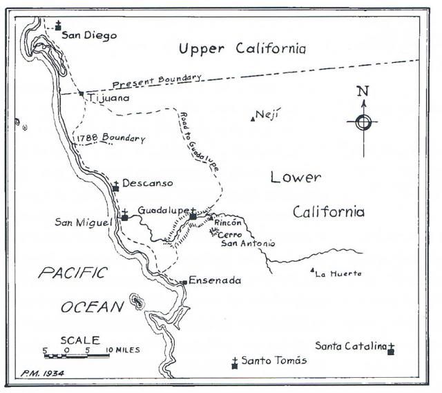
Here is a sketch showing an interpretation the 1788 border location. The PM 1934 in the lower left hand corner shows the authorship to be Peveril
Meigs, this from an unpublished 1934 manuscript. A year later Meigs did publish The Dominican Mission Frontier of Lower California.
John
|
|
|
David K
Honored Nomad
        
Posts: 65361
Registered: 8-30-2002
Location: San Diego County
Member Is Offline
Mood: Have Baja Fever
|
|
1931 Meigs Map
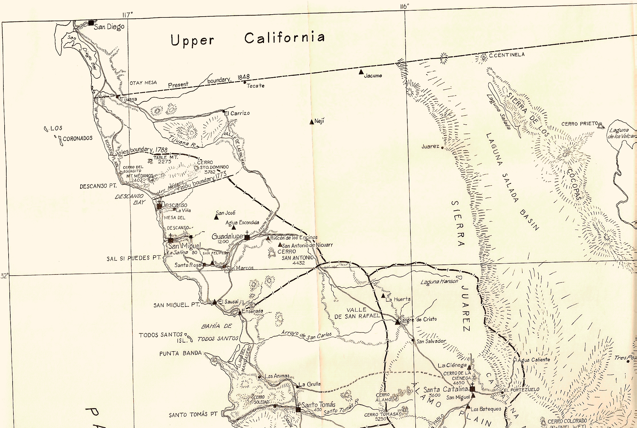
Here is a close up showing the two mission boundary lines:
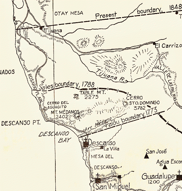
In 1773, Francisco Palóu made the first boundary to separate his Franciscan zone of Alta California from the Dominican zone of Baja California. The
Médano Range was the original 'natural' division point. Palóu made a large cross from a sycamore tree and placed it on a high rock close to the road
(El Camino Real) to serve as a marker. This would be about where Cantamar is today, just south of Puerto Nuevo.
This boundary was short-lived and was moved north 15 years later. Father Sales was responsible for the move to 'Arroyo del Rosarito' shortly after
founding the mission of San Miguel, in 1788.
This boundary of 1773 and then 1788 was only a separation between the Franciscan and Dominican serviced areas. There was no government political
division of California until 1804.
|
|
|
David K
Honored Nomad
        
Posts: 65361
Registered: 8-30-2002
Location: San Diego County
Member Is Offline
Mood: Have Baja Fever
|
|
The exact date in 1773 was August 19th...
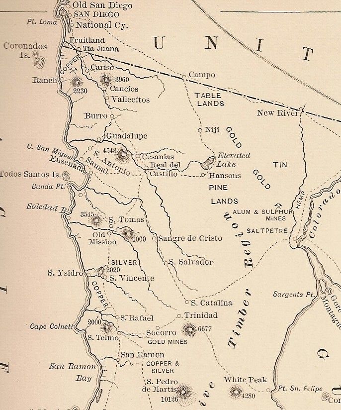
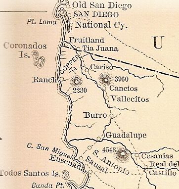
OK, now back to Ken's original question about Tia Juana...
Here it is on an 1888 map:
|
|
|
David K
Honored Nomad
        
Posts: 65361
Registered: 8-30-2002
Location: San Diego County
Member Is Offline
Mood: Have Baja Fever
|
|
Here's a photo from around 1926 showing the boulder that Palóu likely put his boundary cross in... and the mission ruins of San Miguel (in today's
town of La Mision)...
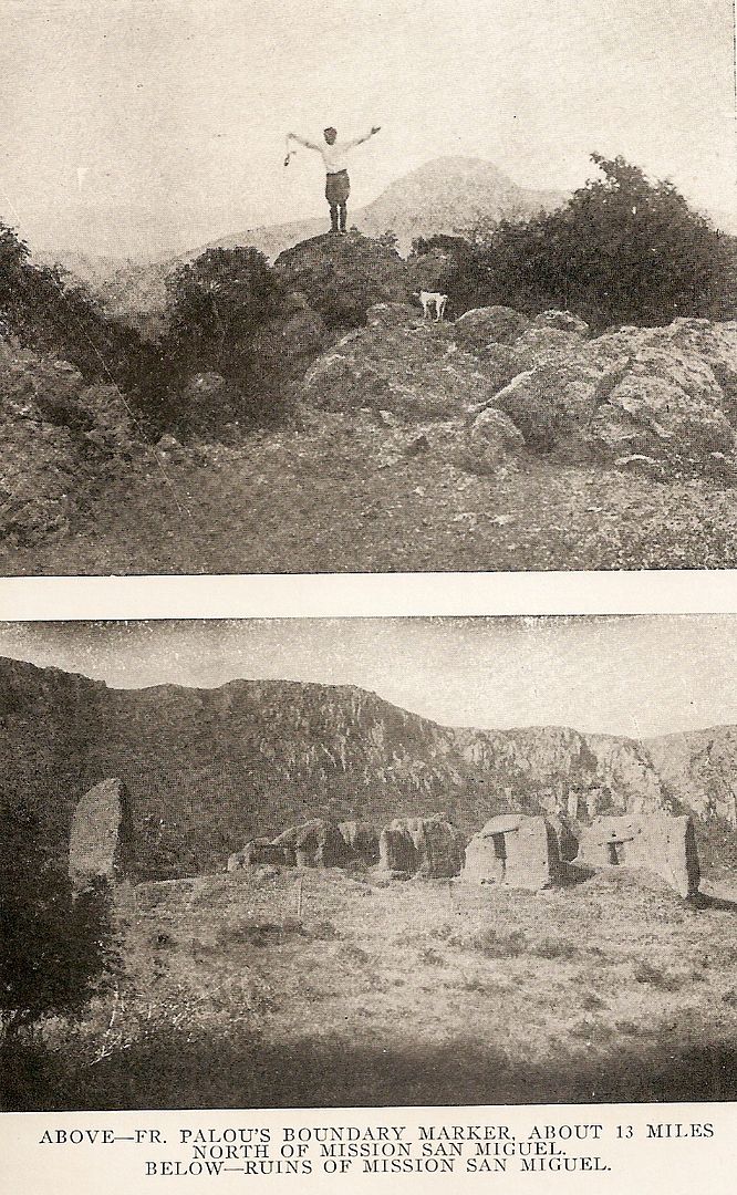
From Engelhardt's 1929 book: The Missions and Missionaries of California
[Edited on 8-20-2013 by David K]
|
|
|
durrelllrobert
Elite Nomad
     
Posts: 7393
Registered: 11-22-2007
Location: Punta Banda BC
Member Is Offline
Mood: thriving in Baja
|
|
The name Tia Juana (aunt Jane)
www.digthatcrazyfarout.com/oldtj/TJ_history.htm
There are different views on the origin of the name for the town. One belief is that it came from an ancient Indian word, "Tiguan", meaning "close to
the water." Another view holds that the name came from a ranch, Tia Juana’s (Aunt Jane’s) Ranch, owned by the Allegro Family. The Allegro Family
partitioned the ranch into various family decided to divide the ranch into sections of a city grid in the Tia Juana Valley.
The City
"Tia Juana, the last town in Southern California . The boundary line passes through it and cuts it in two, the American half consisting of a single
street of frame buildings and a few scattered houses. The American part has a live air but the Mexican part is the deadest place imaginable." (Note:
Probably the California town would have looked just as dead except that, due to the floods in 1891, the old town was washed out and the remaining
buildings were moved to higher ground near the border.) (from Let's Ride the Dam Train!, A sketch from the pen of Hiram H. Bice, Editor of the
National City Record, edition of May 5, 1892). This probably was the beginning of Tijuana, "from ranch to metropolis" (Rosas, 1998, "The City")
Bob Durrell
|
|
|
bajaguy
Elite Nomad
     
Posts: 9247
Registered: 9-16-2003
Location: Carson City, NV/Ensenada - Baja Country Club
Member Is Offline
Mood: must be 5 O'clock somewhere in Baja
|
|
Deja Vu all over again
That's what I said up there ^^^^
| Quote: | Originally posted by durrelllrobert
www.digthatcrazyfarout.com/oldtj/TJ_history.htm
There are different views on the origin of the name for the town. One belief is that it came from an ancient Indian word, "Tiguan", meaning "close to
the water." Another view holds that the name came from a ranch, Tia Juana’s (Aunt Jane’s) Ranch, owned by the Allegro Family. The Allegro Family
partitioned the ranch into various family decided to divide the ranch into sections of a city grid in the Tia Juana Valley.
The City
"Tia Juana, the last town in Southern California . The boundary line passes through it and cuts it in two, the American half consisting of a single
street of frame buildings and a few scattered houses. The American part has a live air but the Mexican part is the deadest place imaginable." (Note:
Probably the California town would have looked just as dead except that, due to the floods in 1891, the old town was washed out and the remaining
buildings were moved to higher ground near the border.) (from Let's Ride the Dam Train!, A sketch from the pen of Hiram H. Bice, Editor of the
National City Record, edition of May 5, 1892). This probably was the beginning of Tijuana, "from ranch to metropolis" (Rosas, 1998, "The City")
|
|
|
|

