Ateo
Elite Nomad
     
Posts: 5947
Registered: 7-18-2011
Member Is Offline
Mood: Just trying to close my Baja Nomad accountâ¦.
|
|
Rancho Nuevo
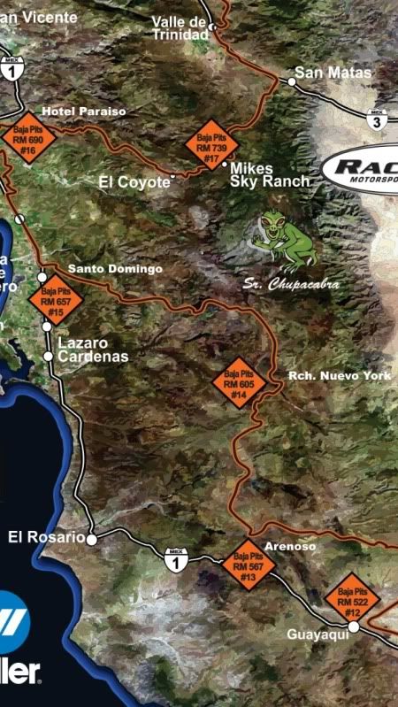
Anyone know the road conditions into the Rancho Nuevo York (Rancho Nuevo - in the Almanac) area northeast of El Rosario/East of San Quintin????
[Edited on 10-30-2013 by Ateo]
|
|
|
TMW
Select Nomad
      
Posts: 10659
Registered: 9-1-2003
Location: Bakersfield, CA
Member Is Offline
|
|
What race mile is it near.
|
|
|
Ateo
Elite Nomad
     
Posts: 5947
Registered: 7-18-2011
Member Is Offline
Mood: Just trying to close my Baja Nomad accountâ¦.
|
|
You are a wizard TW. I was just U2U'ing you when I saw you responded to this thread! Race Mile 605. It's pit # 14 for Baja Pits. My Almanac just
lists "Rancho Nuevo" so I'm guessing that's the one. It's at the base of the San Pedro Martir.
|
|
|
Ateo
Elite Nomad
     
Posts: 5947
Registered: 7-18-2011
Member Is Offline
Mood: Just trying to close my Baja Nomad accountâ¦.
|
|
|
|
|
woody with a view
PITA Nomad
      
Posts: 15940
Registered: 11-8-2004
Location: Looking at the Coronado Islands
Member Is Offline
Mood: Everchangin'
|
|
i'm guessing you'll be the first!
|
|
|
Ateo
Elite Nomad
     
Posts: 5947
Registered: 7-18-2011
Member Is Offline
Mood: Just trying to close my Baja Nomad accountâ¦.
|
|
| Quote: | Originally posted by woody with a view
i'm guessing you'll be the first! |
Holy crap yeah. Haven't seen many trip reports from this area. Google Earth shows about 400 roads -- all going different directions and detouring
every few miles. Gonna have to turn on my Zen Baja Road Choosing Capabilities.
[Edited on 10-30-2013 by Ateo]
|
|
|
TMW
Select Nomad
      
Posts: 10659
Registered: 9-1-2003
Location: Bakersfield, CA
Member Is Offline
|
|
Here is a trip report I did New Years for the area to the west of the ranch.
http://forums.bajanomad.com/viewthread.php?tid=64875
Here are the Google Earth pictures of the access roads starting at Hwy 1. You'll probably go in at KM24.
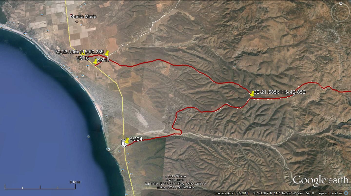
The second Jct with the white line going south is the 2007 race course. Before getting to it is a down hill section with a deep rut pick your line
carefully, maybe use a spotter. In my smaller Tacoma I went left up and around it. Between the 07 course Jct and the next Jct you'll drop into a wash
for about a mile.
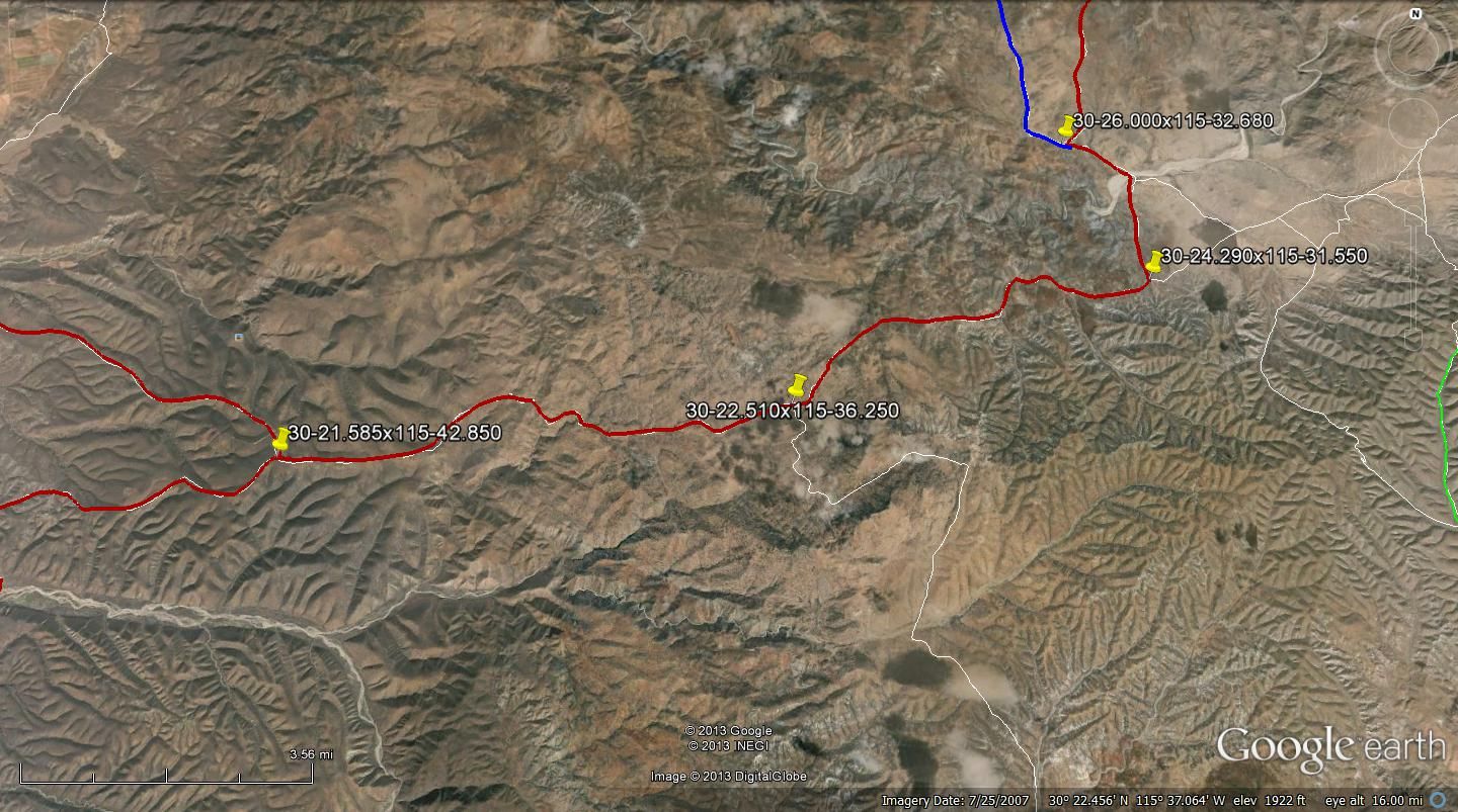
I took the blue line north so I have not been on the red section from there on.
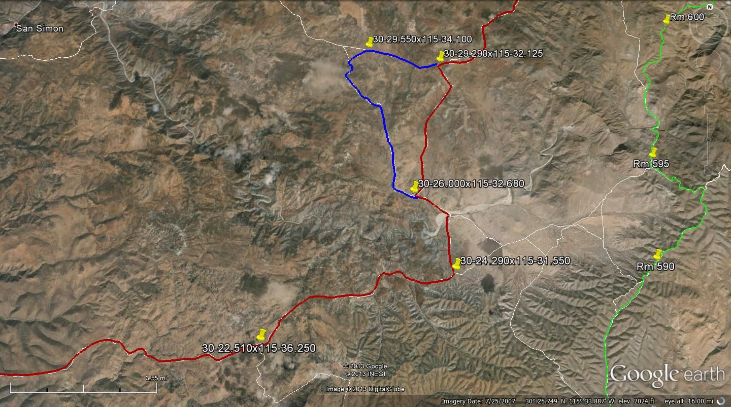
This shows the access roads to RM605. It looks like when you get ready to leave just follow the race course north to the first red Jct then follow the
red line out and back to where you came in from Hwy 1.
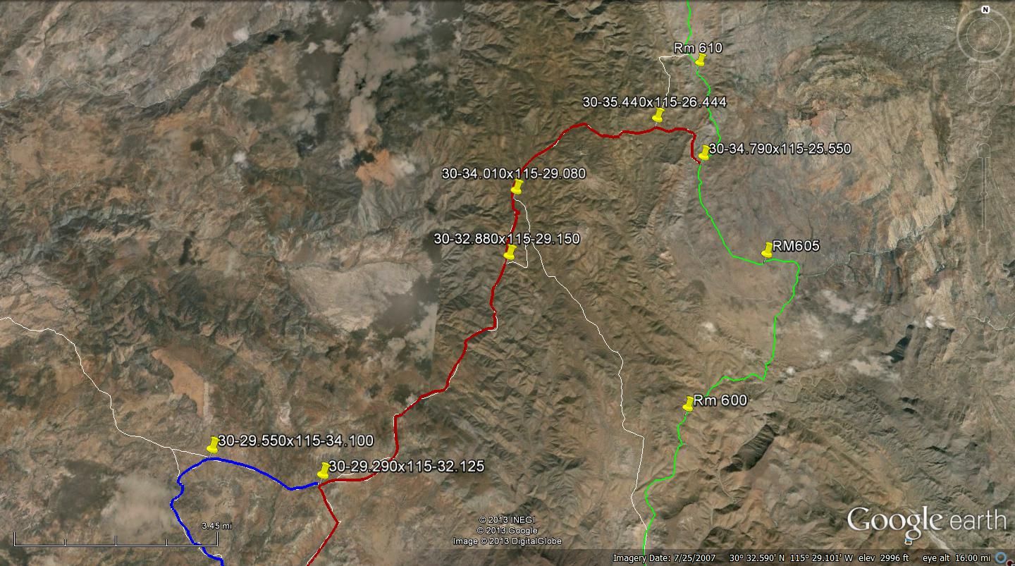
Hope this helps.
|
|
|
Mexitron
Ultra Nomad
    
Posts: 3397
Registered: 9-21-2003
Location: Fort Worth, Texas
Member Is Offline
Mood: Happy!
|
|
| Quote: | Originally posted by Ateo
| Quote: | Originally posted by woody with a view
i'm guessing you'll be the first! |
Holy crap yeah. Haven't seen many trip reports from this area. Google Earth shows about 400 roads -- all going different directions and detouring
every few miles. Gonna have to turn on my Zen Baja Road Choosing Capabilities.
[Edited on 10-30-2013 by Ateo] |
lots of new roads from the yucca harvesters, along with ranchers, etc.
|
|
|
Ateo
Elite Nomad
     
Posts: 5947
Registered: 7-18-2011
Member Is Offline
Mood: Just trying to close my Baja Nomad accountâ¦.
|
|
Thanks for commenting Mexitron. I hope it doesn't rain.
TW: Just like to give you a public "Thanks" for all the time you spent discussing this with me.
|
|
|
TMW
Select Nomad
      
Posts: 10659
Registered: 9-1-2003
Location: Bakersfield, CA
Member Is Offline
|
|
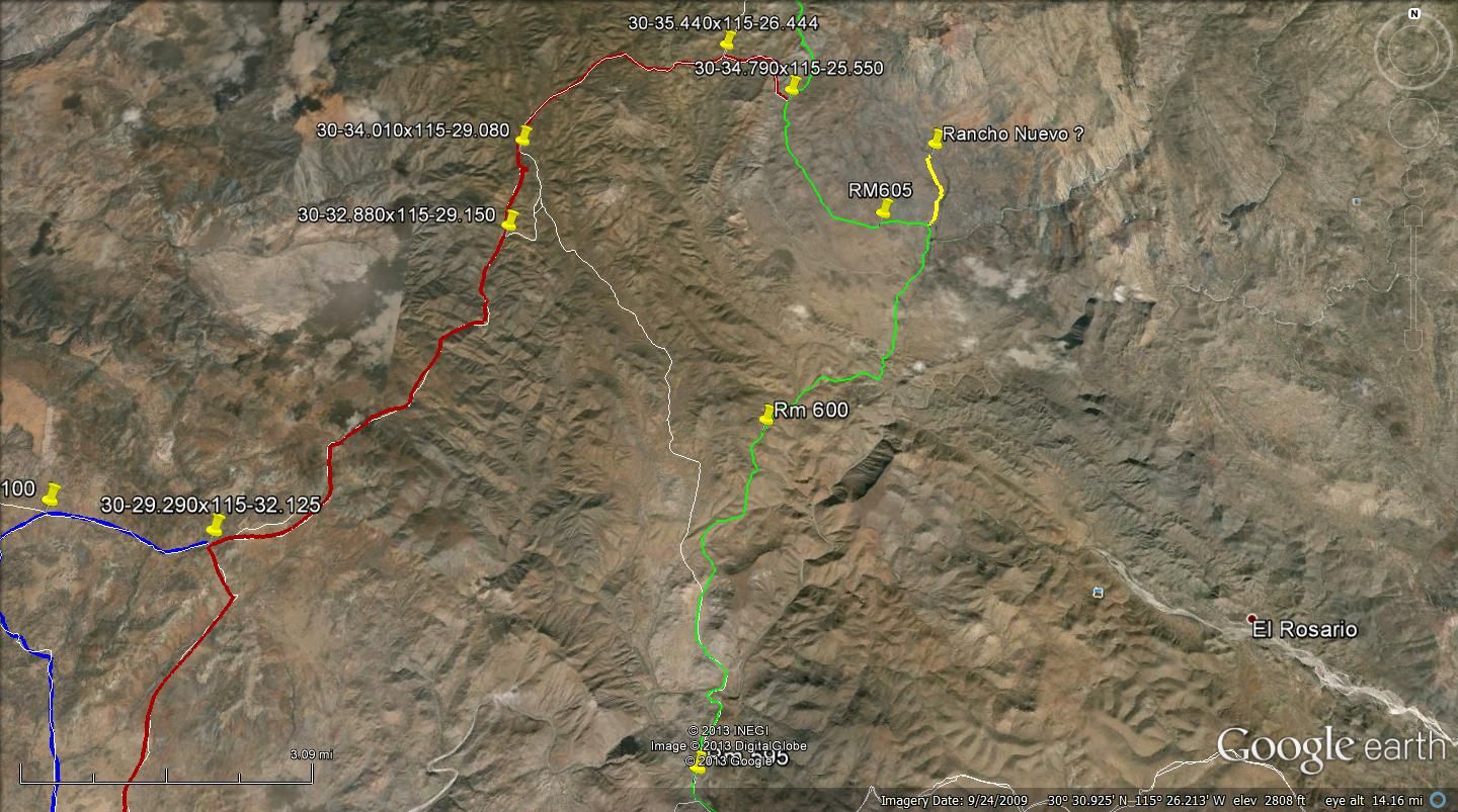
Here are Google Earth pictures of the race course from Hwy 1 to RM610.
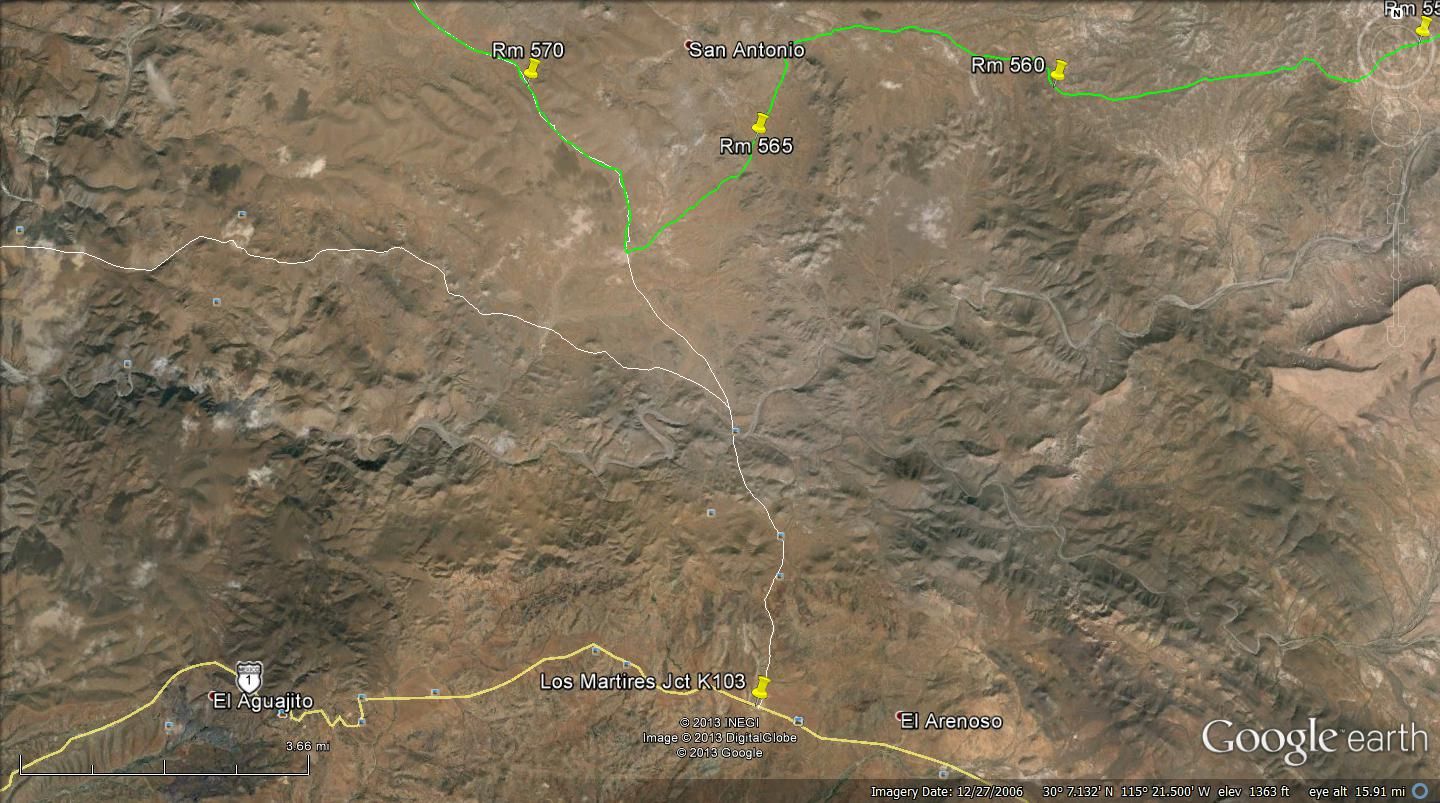
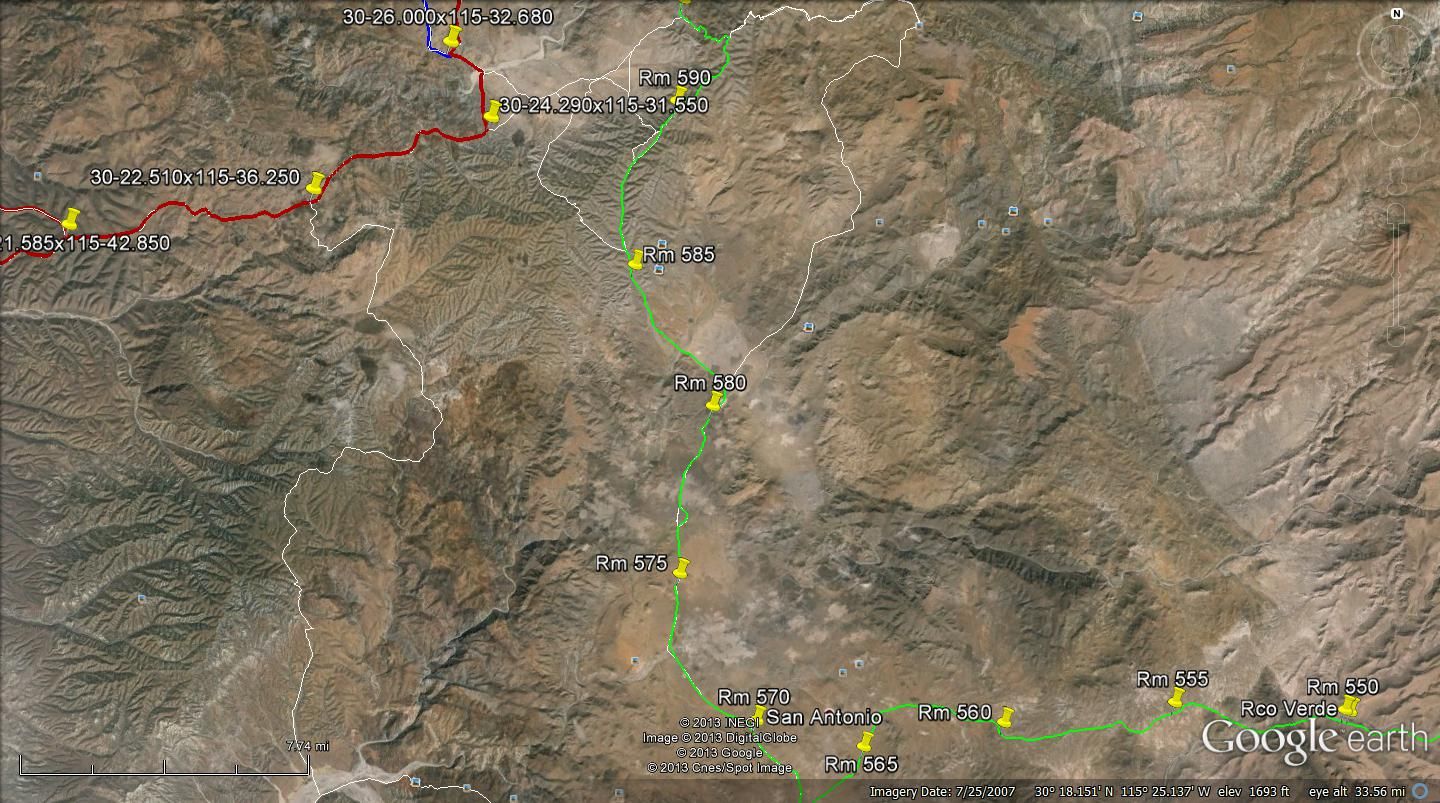
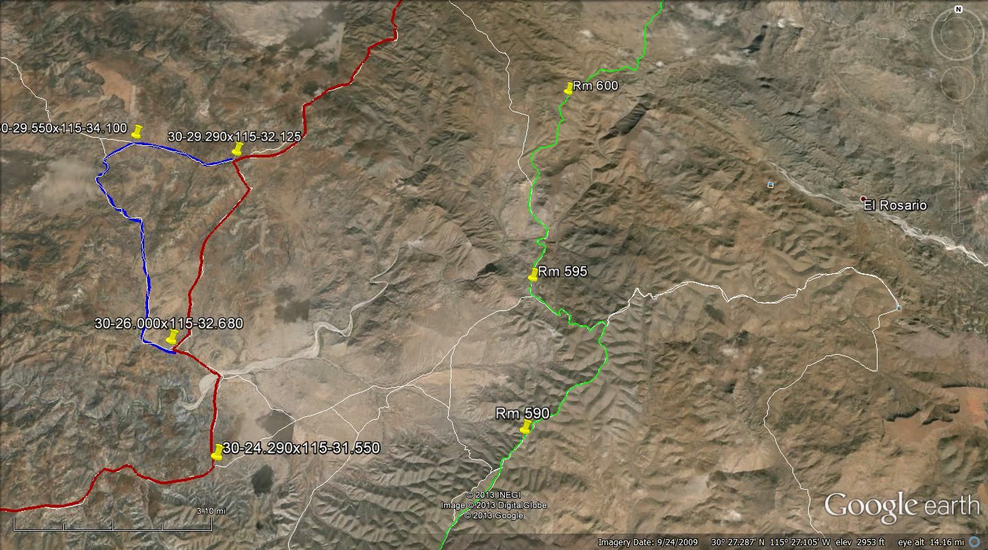
Note the yellow rd to the right before RM605. There is a corral and maybe a ranch house, it maybe Ranch Nuevo, hard to see the bldgs on GE. The
corrdinates for R. Nuevo in the almanac is way off as compared to GE.
|
|
|
Timo1
Senior Nomad
  
Posts: 761
Registered: 11-2-2007
Location: Homeless
Member Is Offline
Mood: Lovin every minute of it
|
|
When is the B1000 ???
sold out and got out !!!
|
|
|
TMW
Select Nomad
      
Posts: 10659
Registered: 9-1-2003
Location: Bakersfield, CA
Member Is Offline
|
|
Nov. 14-17. Starts and ends in Ensenada. Bikes start Thursday Nov. 14 at 11pm. Cars/trucks start Friday Nov. 15 at 9am. Start and finish line is in
front of the Riviera del Pacifico Cultural Center. Some call it the Convention Center. Large white building to the left before the light at hotel
Corona.
|
|
|
wessongroup
Platinum Nomad
       
Posts: 21152
Registered: 8-9-2009
Location: Mission Viejo
Member Is Offline
Mood: Suicide Hot line ... please hold
|
|
Something about "races" ... still enjoy ... keep it on the dirt ..  
[Edited on 11-2-2013 by wessongroup]
|
|
|
David K
Honored Nomad
        
Posts: 65436
Registered: 8-30-2002
Location: San Diego County
Member Is Offline
Mood: Have Baja Fever
|
|
Well... there is a Rancho Nuevo and a Rancho Nueva York... two different places but both in the sierra foothills east of Hwy. 1.
Looks like the Baja Pits poster map has 'York' added, wrong. 
Rancho Nuevo is just west , on the other side of the sierra from Rancho Matomi.
Rancho Nueva York is east of Colonia V. Guerrero.
The 1000 course goes to each or close to each...
TW, you might have La Suerte labeled as Nuevo... hard to compare the scales of GE and the Almanac.
|
|
|
Ateo
Elite Nomad
     
Posts: 5947
Registered: 7-18-2011
Member Is Offline
Mood: Just trying to close my Baja Nomad accountâ¦.
|
|
Yeah, I see no "York" on the Baja Almanac in that area. Thanks for all the help Nomads.
|
|
|
David K
Honored Nomad
        
Posts: 65436
Registered: 8-30-2002
Location: San Diego County
Member Is Offline
Mood: Have Baja Fever
|
|
Great region... here is a map from my 2005 trip near there:

bajalou made this to show it also:

Trip Road Log (in miles) and 21 GPS waypoints (Map Datum NAD27)
0.0 Leave Hwy. 1 (28.5 mi. from El Rosario Pemex) at cafe just past Km. 103, head north. 30°03.81', 115°20.87'
2.5 Fork, go left
3.6 El Sauzalito ruins on left at 30°05.89', 115°21.76'
4.9 Cross San Juan de Dios river 30°06.83', 115°21.28'
5.2 Fork, go right (left goes back to El Rosario via La Vibora grade) 30°07.04', 115°21.33'
5.4 Fork, go left (right goes to San Juan de Dios) 30°07.22', 115°21.42'
11.7 Fork, go right (left goes to Rancho Los Martires)
13.5 Cross Arroyo Los Matires/ Arroyo Grande 30°12.37', 115°26.33'
13.7 Road in from left to Rancho Los Martires. Rancho San Antonio is passed about five miles ahead
21.3 Fork just north of Arroyo El Portezuelo crossing, go left (right goes to San Miguel and La Suerte) 30°18.42', 115°42.28'
26.1 Fork, go left (right goes to ranch). Only 4WD beyond here.
27.8 Bulldozed switchback grade to ridge top 30°22.26', 115°29.21'
31.9 Fork, go left (right for La Suerte) 30°24.79', 115°29.21'
32.6 Jcn. with old El Socorro to La Suerte road, turn left 30°25.18', 115°29.72'
33.2 Jcn. with road north to El Agua Escondida 30°24.97', 115°30.27'. A second road north is at 30°24.28', 115°31.51'
37.0 'Petroglyph Park' 30°24.19', 115°33.38'
39.2 Fork, go left (right goes 0.9 mi. to blue palms and beyond) 30°23.58', 115°35.01'
41.2 Jcn. road south to El Canuto 30°22.51', 115°36.24'
43.4 El Cipres (abandoned ranch) 30°22.10', 115°37.98'
49.4 Fork, go left (right to Nuevo Odisea) 30°21.56', 115°42.80'
54.8 Jcn., road in from left to Tres Palmas 30°19.96', 115°46.82'
54.9 Old road to north (to Nuevo Odisea) 30°19.94', 115°46.85'
55.5 Join road along south side of river valley, turn right 30°19.66', 115°47.25'
57.1 Hwy. 1 near El Socorro (Km. 24-25). El Rosario is 20.0 mi. south. 30°19.25', 115°48.77'
|
|
|
TMW
Select Nomad
      
Posts: 10659
Registered: 9-1-2003
Location: Bakersfield, CA
Member Is Offline
|
|
Rancho La Suerte is about 4 miles due east of RM 605 on GE at
30-33.540x115-18.220. Ranch Nuevo in the Almanac is at 30-28.xxX115-17.xx. The Ranch at RM605 is at 30-34.160x115-23.630.
|
|
|
TMW
Select Nomad
      
Posts: 10659
Registered: 9-1-2003
Location: Bakersfield, CA
Member Is Offline
|
|
I don't know if the names of some places on Google Earth are accurate, I take them with a grain of salt unless I know for sure. I do know that the
roads and routes in the almanac are not always accurate as to location and I use it as a reference only, it may or may not be accurate.
|
|
|
David K
Honored Nomad
        
Posts: 65436
Registered: 8-30-2002
Location: San Diego County
Member Is Offline
Mood: Have Baja Fever
|
|
Yup, it isn't easy... and I said "might" as to Nuevo vs. Suerta... Just not sure at a glance. I am sure Jon will find his pit and have a blast. I wish
I was going!!
|
|
|

