StuckSucks
Super Nomad
   
Posts: 2366
Registered: 10-17-2013
Member Is Offline
|
|
Spring Break at Gonzaga Bay
Better late ...
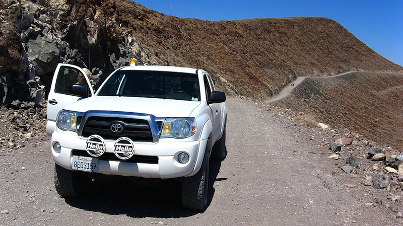
I just posted a clump of photos to my web site from a Spring trip to Gonzaga Bay in 2008 - there's some good shots of the then dirt road. My wife and
I went with friends, and as expected, had a killer time.
http://pizzamanagement.com/spring-break-at-gonzaga-bay/

|
|
|
jbcoug
Senior Nomad
  
Posts: 709
Registered: 9-24-2006
Location: Vancouver, WA
Member Is Offline
Mood: Needing Baja!
|
|
Absolutely better late than never. Really enjoyed your trip!
\"The average dog is a nicer person than the average person.\" Andy Rooney
|
|
|
BajaRat
Super Nomad
   
Posts: 1304
Registered: 3-2-2010
Location: SW Four Corners / Bahia Asuncion BCS
Member Is Offline
Mood: Ready for some salt water with my Tecate
|
|
Thanks for the photos 
|
|
|
dizzyspots
Senior Nomad
  
Posts: 603
Registered: 9-22-2008
Location: Mescal AZ
Member Is Offline
Mood: rather be on the beach at Gonzaga
|
|
Thanks for the memories...glad we got to drive the old road...2007, but now love the new highway..would rather be AT Gonzaga the driving TO Gonzaga
|
|
|
David K
Honored Nomad
        
Posts: 65361
Registered: 8-30-2002
Location: San Diego County
Member Is Offline
Mood: Have Baja Fever
|
|
Thanks for sharing!
|
|
|
micah202
Super Nomad
   
Posts: 1615
Registered: 1-19-2011
Location: vancouver,BC
Member Is Offline
|
|
.
....the road shown above is in the Peurtecitos area??
....I remember something like that from the 80's,,,,though my recollection was that it was in a lot rougher condition,,,rocks all over,,,,burnt out
cars,,,,barely passable and rather desolate feel to it--quite an adventure at the time.
...being before internet,,,I was simply following what was labelled on the map as the Peurtecitos Highway,,,what seemed lik a handy -shortcut- to the
south on my first Baja adventure........what an eyeopener -that- was! 
......further south there was an arroyo that had been run hard reasonably recently,,with the roadway broken away,,,and a not readily apparent
diversion to get across .....it all became my first big baja adventure,,driving down a long sand-grade,,realizing the only reason I wasn't getting
stuck was the downhill grade,,then seeing the road washed away ,stopping,,and omg-no escape in a -totally- desolate barren land!!
...of course some natives showed up within 10 minutes in a flatbed dually,,had us out in minutes and laughed when we offered some coin!.......great
memories of a barren land and it's beautiful people! 
[Edited on 7-12-2014 by micah202]
|
|
|
Ateo
Elite Nomad
     
Posts: 5928
Registered: 7-18-2011
Member Is Offline
|
|
What wonderful photos. Crazy Chubasco story. Hope the truck didn't get damaged by the sand blasting.
|
|
|
StuckSucks
Super Nomad
   
Posts: 2366
Registered: 10-17-2013
Member Is Offline
|
|
Thanks for the kind works everyone.
I'm been lucky (like many of you) - I've been over three iterations of the Gonzaga road - in the 70s and 80s when it was a true 4x4 road south of
Puertocitos, then the graded thing, and now the creeping black death.
re: sandblasting. My white truck has this nice matte finish (this includes windows). Baja tested, eh?
|
|
|
David K
Honored Nomad
        
Posts: 65361
Registered: 8-30-2002
Location: San Diego County
Member Is Offline
Mood: Have Baja Fever
|
|
| Quote: | Originally posted by StuckSucks
Thanks for the kind works everyone.
I'm been lucky (like many of you) - I've been over three iterations of the Gonzaga road - in the 70s and 80s when it was a true 4x4 road south of
Puertocitos, then the graded thing, and now the creeping black death.
re: sandblasting. My white truck has this nice matte finish (this includes windows). Baja tested, eh? |
I like your name for pavement, 'creeping black death'! LOL
The original road built between Puertecitos and Gonzaga Bay in the late 1950's was my first introduction to Baja (1965) and drove it myself in '74,
'75, and '79 (that last year was pre-running the 1000 section I was to drive and was the worst condition of all). When they graded the new roadbed in
1986, for awhile it was the first time any 2WD auto could make the drive, but without maintenance it just got too rough for many. The last time it was
'smooth' was before the storms and Baja 1000 of 2005. The graded road that many think was so rough was a super highway compared to the pre-1986 road!
Thank you for your trip report!
|
|
|
willardguy
Elite Nomad
     
Posts: 6451
Registered: 9-19-2009
Member Is Offline
|
|
| Quote: | Originally posted by StuckSucks
Thanks for the kind works everyone.
I'm been lucky (like many of you) - I've been over three iterations of the Gonzaga road - in the 70s and 80s when it was a true 4x4 road south of
Puertocitos, then the graded thing, and now the creeping black death.
re: sandblasting. My white truck has this nice matte finish (this includes windows). Baja tested, eh? |
lets not forget, 10 years before that when the road was barely a path, a 20 year old Alfonsina would make that trip to mexicali, alone, in the middle
of the night to escape the summer heat, in that old piece of crap pick-up truck, no a.c.,gps,traction control, bald tires, and didn't think anything
of it!
|
|
|
StuckSucks
Super Nomad
   
Posts: 2366
Registered: 10-17-2013
Member Is Offline
|
|
| Quote: | Originally posted by David K
The graded road that many think was so rough was a super highway compared to the pre-1986 road!
Thank you for your trip report! |
Agreed and da nada.
Non-sequitur time. In June 86, a friend and I thought we needed to experience the sun directly overhead - something that never happens in SoCal. It
only made sense to drive down Baja and hang out on Highway 1 where it intersects with the Tropic of Cancer for the Summer Solstice. We took a straight
pipe, a level and a video camera, and when the sun reached solar noon at our location (I think that was 12:47pm), we got to see the plumb pipe's
shadow disappear. No shadows also made the desert/everything look very flat.
On the return trip norte, we left La Paz at 3am and made it to San Felipe (via Gonzaga) in time for dinner at El Nido (less traffic than today, we
expedited). Much of the Gonzaga road was graded, but we reached a point half way up to Puertocitos where the road crews were working on the road. We
picked up one of the workers (end of day) and gave him a ride to his home in San Felipe. So on this trip, we got to see the road half-and-half.
That's what I did for a week in June 86.
|
|
|
David K
Honored Nomad
        
Posts: 65361
Registered: 8-30-2002
Location: San Diego County
Member Is Offline
Mood: Have Baja Fever
|
|
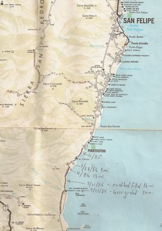
On one of my AAA maps I made notes as to how far the new Gonzaga bound construction was with the date... let's see if I can find it, and if it shows
here well...
Here is the 1987 AAA map with the notes I made as to the advancement of the road grading from Nov., 1985 to July, 1986...

|
|
|

