PaulW
Ultra Nomad

Posts: 3113
Registered: 5-21-2013
Member Is Offline
|
|
Arroyo Grande
Planning the trip. Can anyone give me the coordinates for the dam and any other landmarks at the south end of the canyon? Like to see if I can find
the landmarks.
|
|
|
David K
Honored Nomad
Posts: 65562
Registered: 8-30-2002
Location: San Diego County
Member Is Offline
Mood: Have Baja Fever
|
|
Calling Neal Johns and TW (TMW now)!
|
|
|
David K
Honored Nomad
Posts: 65562
Registered: 8-30-2002
Location: San Diego County
Member Is Offline
Mood: Have Baja Fever
|
|
Paul, here is one post where TMW mentions the dam location a couple of times: http://forums.bajanomad.com/viewthread.php?tid=14140
|
|
|
PaulW
Ultra Nomad
Posts: 3113
Registered: 5-21-2013
Member Is Offline
|
|
Very curious My search for Arroyo Grande did not find that link. Thanks I will start studying.
PW
|
|
|
PaulW
Ultra Nomad
Posts: 3113
Registered: 5-21-2013
Member Is Offline
|
|
I was going to resurrect the 11/21/05 AG thread, but it is to old to allow reply.
http://forums.bajanomad.com/viewthread.php?tid=14140
So here are my observations to TW's post based on my Feb 2012 trip. There was no evidence of the dam, chain link fence, or big rocks. However were
were scooting along at about 30-40 mph so were not very observant.
Several year prior to 2/2012 I did notice the big cable across the wash, but in 2012 AG trip & 2014 PLR trip it was not noticed. I guess it
depends on wheer one drives?
Now I know close enough to look for the dam and rocks for the next trip.
As I reported on another thread we were blocked from getting to AG-the place with buildings due to heavy undergrowth and 6" diameter trees close
together.
Summary :
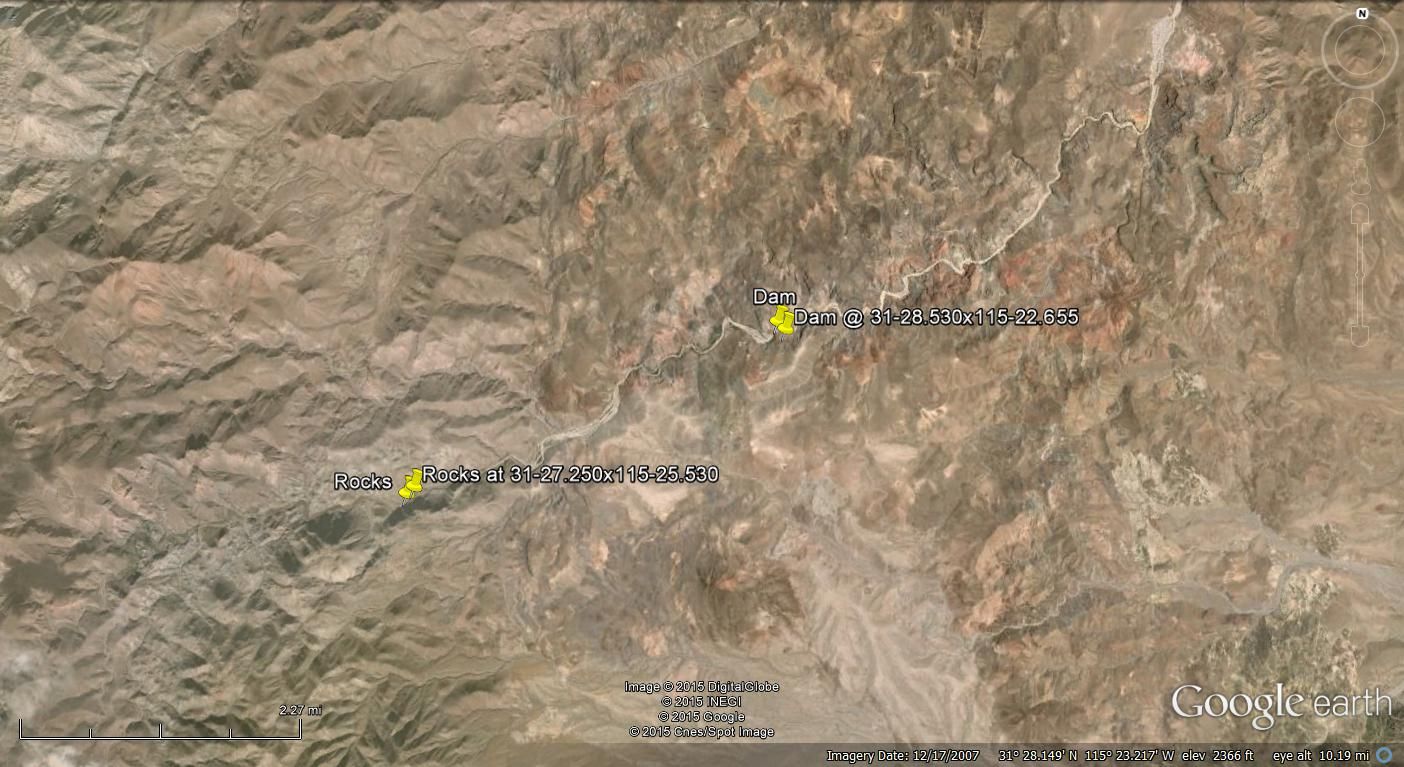
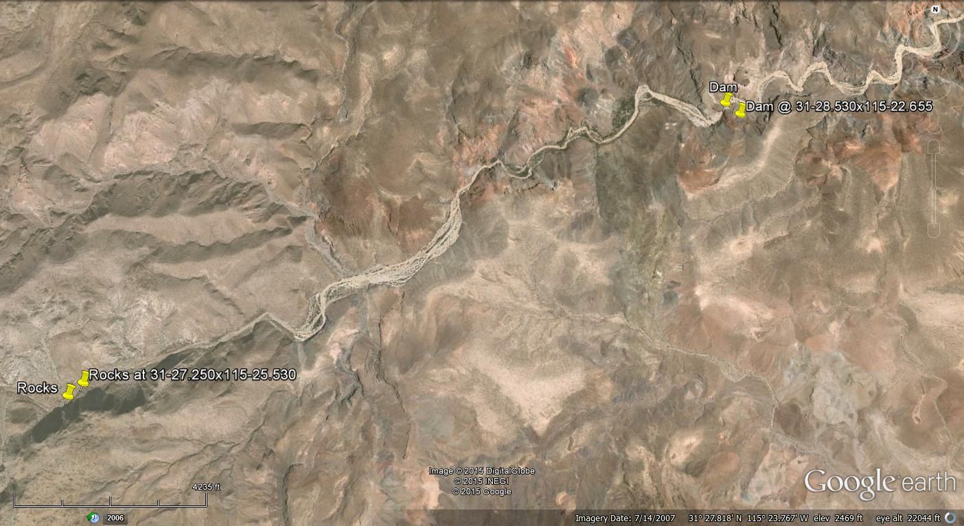
TW: mine wells & pumping facility 31 42 08, -115 15 19
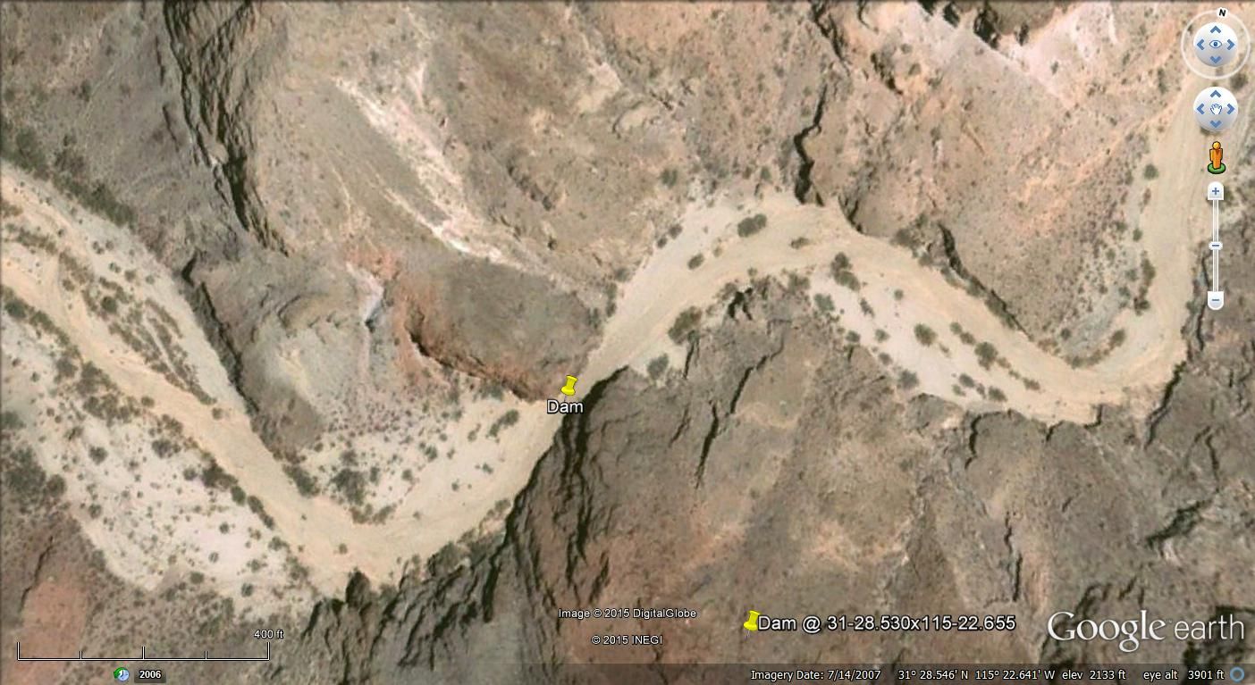
TW: Dam 31 28 31, -115 22 36
TW: Large rocks 31 27 09, -115 25 33
PW: wash Blockage due to trees 31 27.104, -115 26.207
Walked to 31 27.09, -115 26.6
The locked gate at Choyall was pretty secure last time I looked. I will check this out on my next trip to San Matias. I think I can find a go-around
the gate road if required.
Regarding Kens comment on the Tee intersection. I did see that junction when I did the PLR, and assumed it would work for the north Jaq entrance.
We found for the entrance to Jaq - PLR from AG was heavily traveled.
Ken's T is 31 39.041, -115 18.217 and it is correct on GE. I do know that a SF group did that route for their PLR trip. I will try to get a track.
BTW, I am switching to WGS84 and I did not know what TW used, but it hardly matters. Yes I would rather use GE than the INEGI maps.
Paul
|
|
|
David K
Honored Nomad
Posts: 65562
Registered: 8-30-2002
Location: San Diego County
Member Is Offline
Mood: Have Baja Fever
|
|
I think TW's was NAD27... but since we use Google Earth more than the Baja Almanac, and it is the factory setting on GPS units, WGS84 is the way to go
now... perhaps?
My first web pages with GPS waypoints was at WGS84 (2001), but at the time we used the Mexican topos (Baja Atlas and Almanacs) to navigate and they
are drawn to map datum NAD27. Now we are back to using WGS84. Of interest, the difference between the two points is not far... at the 28 parallel near
Santa Gertrudis, it was about 150 feet.
|
|
|
PaulW
Ultra Nomad
Posts: 3113
Registered: 5-21-2013
Member Is Offline
|
|
D,
Pretty sure you are correct. I put in 27 and the poinst moved closer to my track. Still a little off as is normal.
Being pretty new to Baja compared you you all I have had way to difficult time getting the INEGI maps anyway. The ones I wanted seem to always be our
of stock. I depend on GE and my PC track viewer to resolve issues.
Lately I am trying to get up to speed on Bing. To much different that GE to suit me.
Paul
|
|
|
David K
Honored Nomad
Posts: 65562
Registered: 8-30-2002
Location: San Diego County
Member Is Offline
Mood: Have Baja Fever
|
|
Right... just Bing has newer satellite images than GE.
|
|
|
TMW
Select Nomad
Posts: 10659
Registered: 9-1-2003
Location: Bakersfield, CA
Member Is Offline
|
|
When I did the GPS reading then I was using Hr-Min-Sec Datum27. The dam was pretty much washed out when we where there. Made of chicken wire and
rocks. There were the remains of where someone was living there in a primative fashion on the north side of the arroyo at the dam.
|
|
|
TMW
Select Nomad
Posts: 10659
Registered: 9-1-2003
Location: Bakersfield, CA
Member Is Offline
|
|
Here is a DE view of the Dam and Rock with GPS points.
|
|
|
TMW
Select Nomad
Posts: 10659
Registered: 9-1-2003
Location: Bakersfield, CA
Member Is Offline
|
|
Better Picture
|
|
|
PaulW
Ultra Nomad
Posts: 3113
Registered: 5-21-2013
Member Is Offline
|
|
Tom,
I put you coords (WGS84) above into my gps over my last track. The dam is exactly on my track. The rocks are somewhat SW for my track.
Reading Bruce Barbers account, he said the dam was in a side gully???
As for rocks - they come and go. A great example is the condition now in Matomi and past condition of Huatamote.
Paul
|
|
|
TMW
Select Nomad
Posts: 10659
Registered: 9-1-2003
Location: Bakersfield, CA
Member Is Offline
|
|
The dam was at a narrowing of the arroyo not a side gully. The walls are maybe 20+ feet high. It's hard to say how high the dam may have been but my
guess is maybe 6 feet based on the wire we saw. Last Jan. XRPHLang and I were at the dam and it was basically gone. On the bank to the left of the
dam is were someone had been living years ago. I took the GPS reading originally in around 2007. I was riding my MC and my brother was in my GMC. When
we got to where the rock pin is the rocks were too much for the GMC to get over or around at that time. I noticed on GE that there is a road at the
top of the rocks that goes across.
|
|
|
PaulW
Ultra Nomad
Posts: 3113
Registered: 5-21-2013
Member Is Offline
|
|
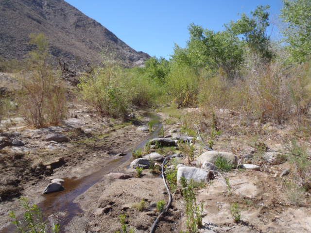
AG Update
Arroyo Grande update 2.27.2015
Lots of changes due to water flow over various summers. In the screen shot below you can see how far we got. What we found was water flowing about 1ft
deep and plenty of new growth. Had to make new track due because I lost the old one in the bushes in several places. When I get time I will update the
GPS track.
I was unable to reach Toms rocks and the option was to drive up/down the bank. Easy. We found several other places where we left the wash and used the
bank up & down and still had to drive over medium sized rocks. Note the new dead end cords under the cross hairs.
The picture was taken from where I turned around. Nearby I found lots of cattle & horse paths on the hill side to the east. It appears they come
down from the divide to get to the water.
The other picture shows the remains of the dam.
More about the trip later
Paul
Screen shot
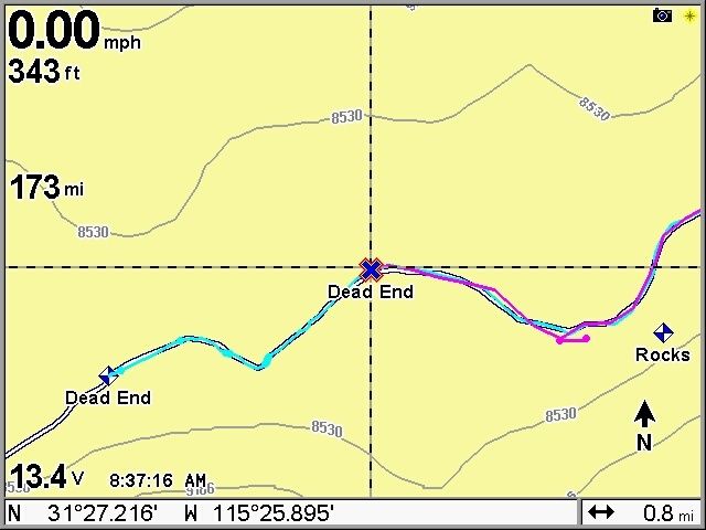
End of the track
Dam

|
|
|
TMW
Select Nomad
Posts: 10659
Registered: 9-1-2003
Location: Bakersfield, CA
Member Is Offline
|
|
Thanks Paul.
|
|
|
PaulW
Ultra Nomad
Posts: 3113
Registered: 5-21-2013
Member Is Offline
|
|
Some canyon pics
Dam Narrows
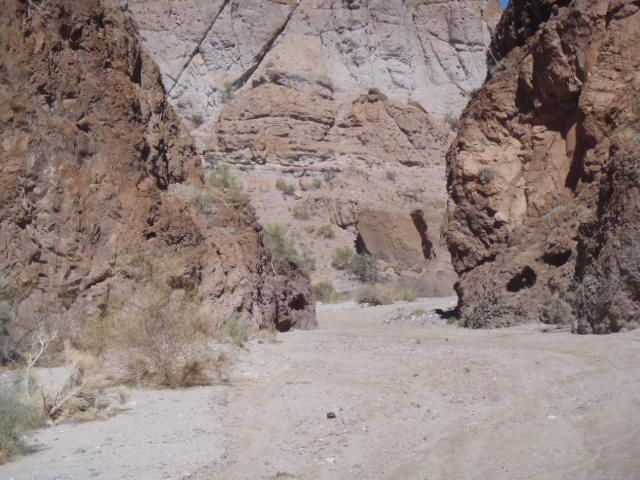
Canyon Rocks
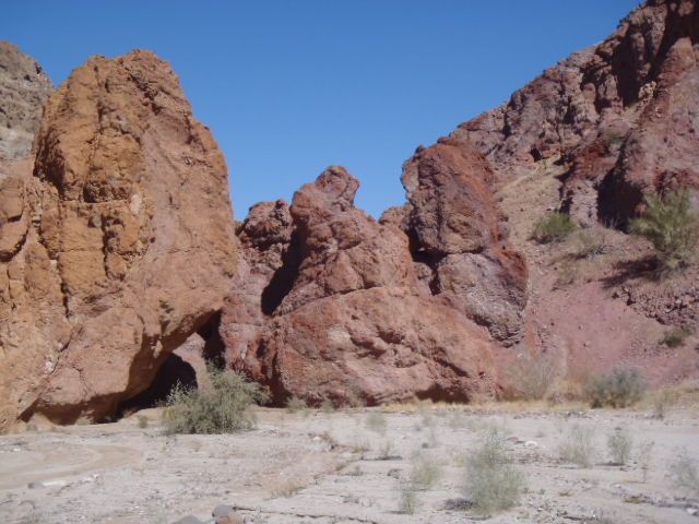
Rigs parked

Typical side wash looking east

|
|
|


