ehall
Super Nomad

Posts: 1906
Registered: 3-29-2014
Location: Buckeye, Az
Member Is Offline
Mood: It's 5 o'clock somewhere
|
|
El Mano Pass
Anyone been on this lately? Any locked gates? How about the summit road?
|
|
|
PaulW
Ultra Nomad
Posts: 3113
Registered: 5-21-2013
Member Is Offline
|
|
=====
Mano - Passable with permission from the land owner. Go find the ranch house and pay and the gates will be unlocked. Been that way for quite a while.
Race summit is as always on the south side. On the north side do not open gates because the road goes around all the new fencing. Been that way for
the last 2 years.
|
|
|
ehall
Super Nomad
Posts: 1906
Registered: 3-29-2014
Location: Buckeye, Az
Member Is Offline
Mood: It's 5 o'clock somewhere
|
|
Thanks paul. Is the ranch at the top or bottom?
|
|
|
TMW
Select Nomad
Posts: 10659
Registered: 9-1-2003
Location: Bakersfield, CA
Member Is Offline
|
|
Top
|
|
|
ehall
Super Nomad
Posts: 1906
Registered: 3-29-2014
Location: Buckeye, Az
Member Is Offline
Mood: It's 5 o'clock somewhere
|
|
Thanks tom
|
|
|
David K
Honored Nomad
Posts: 65562
Registered: 8-30-2002
Location: San Diego County
Member Is Offline
Mood: Have Baja Fever
|
|
If it's of any use for you Ed, I have some GPS waypoints along that road from Hwy. 3 (north of Independencia) to Guadalupe Canyon.
http://www.vivabaja.com/GPS/
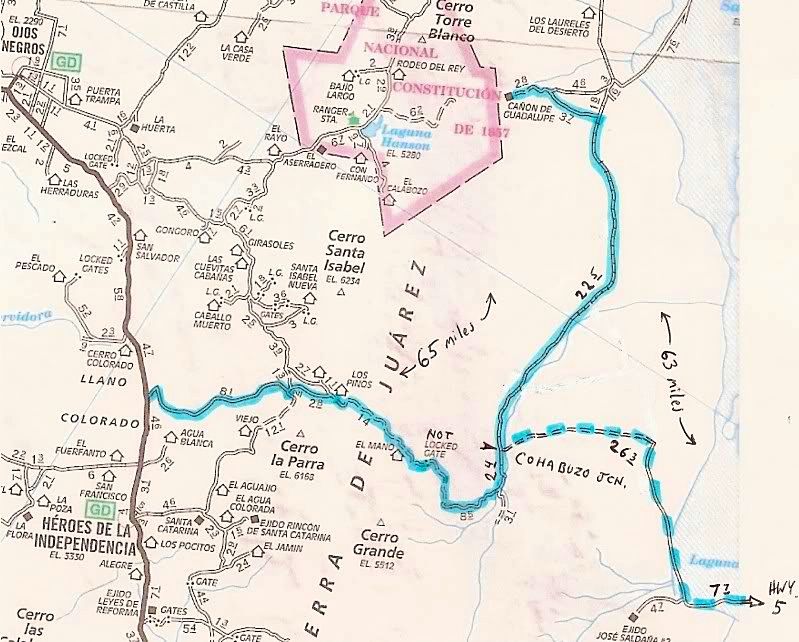
MAP DATUM NAD27 MEXICO:
Guadalupe Canyon Entrance: 32°09.40'/ 115°47.29'
Cohabuzo Jcn: 31°55.74'/ 115°36.22' (*Turn left/ east for next 2 waypoints)
*Ej. Saldana Road (S): 31°50.12'/ 115°19.47'
*Hwy. 5 & Ej. Saldana Jcn: 31°51.75'/ 115°10.92'
South of Cohabuzo 8.2 mi. is a fork, go right for El Mano (4WD): 31°49.81'/ 115°33.89'
Jcn. with road to left. Ahead-right goes up the mountain via El Mano canyon: 31°47.68'/ 115°36.65'
Rancho El Mano driveway left, road begins major climb: 31°48.56'/ 115°40.39'
Rancho Los Pinos, elev. 5,086': 31°48.77'/ 115°46.26'
Jcn. Santa Catarina left (S)/ Agua Blanca right (SW): 31°45.20'/ 115°51.52'
Jcn. Agua Blanca left (S), Hwy. 3 right (N): 31°42.24', 115°54.25'
[Edited on 1-3-2016 by David K]
|
|
|
ehall
Super Nomad
Posts: 1906
Registered: 3-29-2014
Location: Buckeye, Az
Member Is Offline
Mood: It's 5 o'clock somewhere
|
|
Thanks david. That's great.
|
|
|
TMW
Select Nomad
Posts: 10659
Registered: 9-1-2003
Location: Bakersfield, CA
Member Is Offline
|
|
CODE and NORRA ran a race down El Mano in Sept 2013. I went in at Independencia and picked up the race course at RM60 and went down El Mano then to
Cohabuzo Jct and out to Laguna Saluda to Hwy 1. If you want the Google Earth track send me your email by U2U and I'll send it to you. I don't have the
GPS track but you can convert the GE file on http://www.gpsvisualizer.com/
|
|
|
PaulW
Ultra Nomad
Posts: 3113
Registered: 5-21-2013
Member Is Offline
|
|
Both CODE and NORRA had a deal with the rancher to allow passage thru his property. Don't know the cost details
|
|
|
TMW
Select Nomad
Posts: 10659
Registered: 9-1-2003
Location: Bakersfield, CA
Member Is Offline
|
|
When BJ and I went down El Mano in Sept 2013 following the CODE course we were behind two pickup trucks each had a cow in the bed. Not tied and the
cows were slipping and sliding all the way down. We were not in any hurry so we just stayed behind them. Before getting to the abandoned ranch at the
bottom there was a military checkpoint, all but one soldier wanted a beer the other a soda.
|
|
|
TMW
Select Nomad
Posts: 10659
Registered: 9-1-2003
Location: Bakersfield, CA
Member Is Offline
|
|
The west end of the summit road can get confusing with the gates some locked and some not depending on which road you take. We came over it last June.
I think Paul is more familiar with that area.
|
|
|
Ken Cooke
Elite Nomad
Posts: 8971
Registered: 2-9-2004
Location: Riverside, CA
Member Is Offline
Mood: Pole Line Road postponed due to injury
|
|
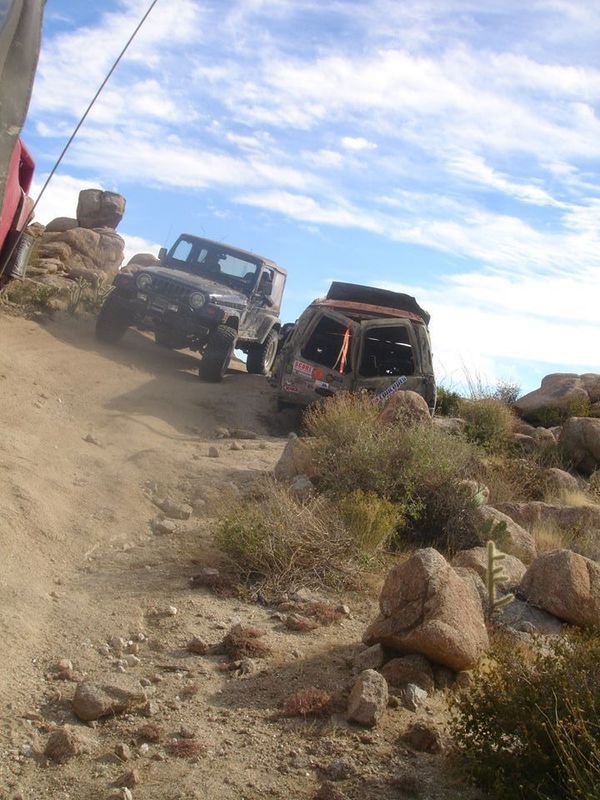
Tom - does this bombed-out Suburban look familiar?
|
|
|
TMW
Select Nomad
Posts: 10659
Registered: 9-1-2003
Location: Bakersfield, CA
Member Is Offline
|
|
No I meant the race summit. I thought that was what Ed was asking about.
Ken I don't recall the Suburban. Was that on El Mano?
|
|
|
David K
Honored Nomad
Posts: 65562
Registered: 8-30-2002
Location: San Diego County
Member Is Offline
Mood: Have Baja Fever
|
|
Ed is asking about Mano Canyon according to the thread, so I posted the old AAA map with that road highlighted and GPS points for the Mano road... Did
I miss something? You even said Mano for the CODE race??
I will delete my reply about Portezuelo de Jamau (Race Summit) since I am confused now! LOL. Goodnight Tom.
[Edited on 1-5-2016 by David K]
|
|
|
TMW
Select Nomad
Posts: 10659
Registered: 9-1-2003
Location: Bakersfield, CA
Member Is Offline
|
|
Your map etc. is good info for Ed. He asked about the summit and I assumed he meant the race summit since I've never heard anyone refer to the top of
El Mano as the summit. But I may have misunderstood his question.
|
|
|
PaulW
Ultra Nomad
Posts: 3113
Registered: 5-21-2013
Member Is Offline
|
|
Yes, he asked about both "Mano Pass" and "summit". I assumed "race summit" like David did. Maybe he meant Mano summit which I ignored.
Let me clarify
CODE and NORRA used Mano with permission and payment. Without permission maybe the gates will be unlocked due to frequent use by the rancher?? I do
not have details where the ranch house for Mano is located. Somebody else needs to provide.
Race summit never needs permission or payment so far. There is a small occupied ranch house near the race summit on the south side. My previous route
description is correct. Ask for more details. The race summit is used all the time by locals and explorers and racers - mostly SCORE.
|
|
|
David K
Honored Nomad
Posts: 65562
Registered: 8-30-2002
Location: San Diego County
Member Is Offline
Mood: Have Baja Fever
|
|
Quote: Originally posted by PaulW  | Yes, he asked about both "Mano Pass" and "summit". I assumed "race summit" like David did. Maybe he meant Mano summit which I ignored.
Let me clarify
CODE and NORRA used Mano with permission and payment. Without permission maybe the gates will be unlocked due to frequent use by the rancher?? I do
not have details where the ranch house for Mano is located. Somebody else needs to provide.
Race summit never needs permission or payment so far. There is a small occupied ranch house near the race summit on the south side. My previous route
description is correct. Ask for more details. The race summit is used all the time by locals and explorers and racers - mostly SCORE.
|
Just for clarification, I assumed El Mano's summit (as in the top of a range or high point on the road). Ken posted a photo I thought was Race Summit
(Portezuelo de Jamau) and that's when things got confused (for me, I guess)!?
Carry on!
|
|
|


