| Pages:
1
2
3
4 |
geoffff
Senior Nomad

Posts: 721
Registered: 1-15-2009
Member Is Offline
|
|
Here is PaulW's track as a GPX file:
Trail-2-Revised-Day-1-H5-Lab-Rd.gpx
-- Geoff
|
|
|
David K
Honored Nomad
Posts: 65561
Registered: 8-30-2002
Location: San Diego County
Member Is Offline
Mood: Have Baja Fever
|
|
geoffff, can you try with another format maybe? I get a 'can't open' message from Adobe when I click that link?
|
|
|
geoffff
Senior Nomad
Posts: 721
Registered: 1-15-2009
Member Is Offline
|
|
It's a GPX file, used by Garmin apps, and can also be dragged into Google Earth.
In any case, here it is again converted into Google Earth format:
Trail-2-Revised-Day-1-H5-Lab-Rd.kml
-- Geoff
|
|
|
TMW
Select Nomad
Posts: 10659
Registered: 9-1-2003
Location: Bakersfield, CA
Member Is Offline
|
|
Thanks for both files. When I converted Paul's file to GE file I got several straight red lines. It showed the mine road but the red lines didn't look
good.
|
|
|
David K
Honored Nomad
Posts: 65561
Registered: 8-30-2002
Location: San Diego County
Member Is Offline
Mood: Have Baja Fever
|
|
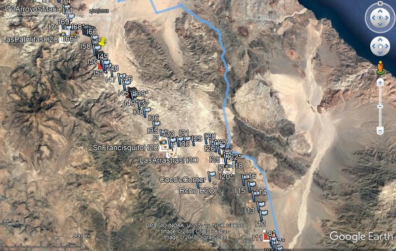
Yes, the KML file works fine, opens up in Google Earth. Thanks!
Here is the route (blue line) on my Google Earth which has the El Camino Real waypoints included (all the numbered marker flag pins) from www.caminorealbaja.com :
|
|
|
PaulW
Ultra Nomad
Posts: 3113
Registered: 5-21-2013
Member Is Offline
|
|
That is the first file with no WPs
==== =
|
|
|
Ken Cooke
Elite Nomad
Posts: 8971
Registered: 2-9-2004
Location: Riverside, CA
Member Is Offline
Mood: Pole Line Road postponed due to injury
|
|
Looks doable for a small-sized group during one day. Should be fun!
|
|
|
| Pages:
1
2
3
4 |


