mtgoat666
Platinum Nomad
       
Posts: 20562
Registered: 9-16-2006
Location: San Diego
Member Is Offline
Mood: Hot n spicy
|
|
Planning trip, help appreciated!
Why do obsessive compulsives with an internet umbilical cord need every foot and minute of the journey outlined on a aaa trip ticket?
Crikey!
Just go and do it!
You got massive 4wd, air compressors, atvs, a boat, and probably two 400 coolers! (Yeti,, I am sure!)
Just go figure it out and don't ask for momma to plot every turn!
If in doubt, go to off road warehouse or REI and spend another $800 for another cool gadget!
[Edited on 10-24-2016 by mtgoat666]
|
|
|
mojo_norte
Senior Nomad
  
Posts: 725
Registered: 2-14-2006
Member Is Offline
|
|
somebody pee in your Wheaties this AM - Devil Goat ?
|
|
|
David K
Honored Nomad
        
Posts: 65436
Registered: 8-30-2002
Location: San Diego County
Member Is Offline
Mood: Have Baja Fever
|
|
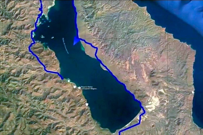
Avoid the road closest to the south end of the bay at km.76 and go to the next road, almost to km.74.
We were on it last month, see the trip report 'The Baja Extreme 2016'.
|
|
|
MMc
Super Nomad
   
Posts: 1679
Registered: 6-29-2011
Member Is Offline
Mood: Current
|
|
What would you do if one road or another is impassable? Go, have a good time. Sometimes, "you buy your ticket take the ride"
"Never teach a pig to sing it frustrates you and annoys the pig" - W.C.Fields
|
|
|
Thornton
Newbie
Posts: 3
Registered: 10-6-2016
Member Is Offline
|
|
Thanks for the comment David K. I had seen that thread, but missed the specific post there.
|
|
|
KasloKid
Nomad
 
Posts: 327
Registered: 8-29-2009
Member Is Offline
|
|
Thornton, I can't offer any advice but envy you for the trip you're planning.
There's a couple of guys that hang out on this forum that have taken their dirt bikes near the areas you're looking for intel on. They'll more than
likely post up their experience.
Of course, every year the access challenges change due to hurricane damage, so it might be difficult to access recent info.
You should be aware that the Baja 1000 SCORE race is taking place Nov 15 - 20th, and pre-running started this weekend. You don't want to be on the
road race day (18th) as chase trucks are in a REAL hurry to get to their next stop. Seriously, be 40 miles or more south of El Rosario before then,
or don't be travelling north at that time.
|
|
|
Thornton
Newbie
Posts: 3
Registered: 10-6-2016
Member Is Offline
|
|
KasloKid: Thanks for that! Had seen that my time frame was gonna overlap the Baja 1000, but hadn't looked up specifics to see how it was gonna impact
travel.
Yeah, that whole zone seemed like it got some good weather through the storm season which is why i'm especially curious on these roads.
|
|
|
KasloKid
Nomad
 
Posts: 327
Registered: 8-29-2009
Member Is Offline
|
|
Thorton... if you want or need to, you can avoid race traffic by taking Mex 5 to San Felipe, through Gonzaga Bay out to Hwy 1 at Lake Chapala, 32
miles south of Catavina. Watch out for the "truck launching vados" north of Puertecitos.
However, if you get an opportunity to go through Catavina either Northbound or Southbound, it's worth the trip as the scenery around there is
memorable.
You're right, Mulege and Loreto got hit pretty hard a month and a half ago by hurricane Odile.... just north of the area you're interested in.
[Edited on 10-24-2016 by KasloKid]
|
|
|
Bajazly
Super Nomad
   
Posts: 1018
Registered: 6-4-2015
Location: Goodbye Cali and Hello San Felipe
Member Is Offline
Mood: More Relaxed Everyday
|
|
In September we tried to get out to San Basiilo and were met with both roads being closed. Seems like Daddy War Bucks who has a house out there
doesn't want any visitors. Love to know if it is accessible, looks like a cool place.
|
|
|
BajaBlanca
Select Nomad
      
Posts: 13247
Registered: 10-28-2008
Location: La Bocana, BCS
Member Is Offline
|
|
I, for one, had never even heard of the two places you are trying to get to and we live here in Baja. It will be very interesting to read your trip
report. bon voyage!
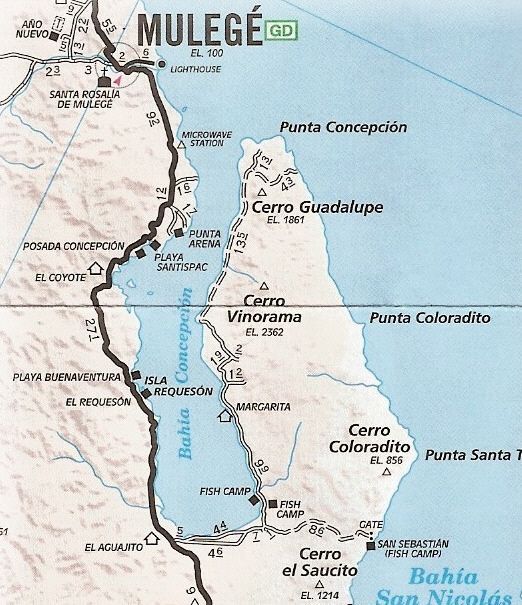
your maps above are very beautiful but it would be nice to see a reference point since I don't know where on highway 1 you start off from?
|
|
|
AKgringo
Elite Nomad
     
Posts: 6308
Registered: 9-20-2014
Location: Anchorage, AK (no mas!)
Member Is Offline
Mood: Retireded
|
|
BajaBlanca, If you were able to zoom out on the top map, you would see the southern end of Bahia Conception on the left, and the Sea of Cortez on the
right.
If you are not living on the edge, you are taking up too much space!
"Could do better if he tried!" Report card comments from most of my grade school teachers. Sadly, still true!
|
|
|
David K
Honored Nomad
        
Posts: 65436
Registered: 8-30-2002
Location: San Diego County
Member Is Offline
Mood: Have Baja Fever
|
|

Here is our GPS track, at the very bottom is the access from near Km. 74:

Here is my recent article about the other side of Concepcion Bay, with a road log: https://www.bajabound.com/bajaadventures/bajatravel/bahia_co...
|
|
|
Thornton
Newbie
Posts: 3
Registered: 10-6-2016
Member Is Offline
|
|
Bajazly: thanks for that. Seems like it's iffy over there. Ideally I'll make it out to Pulpito and then scoot down to San Basilio in the skiff so I
can talk with some folks there and see what the score is.
KasioKid: Been thru that Cataviņa zone before. Super scenic drive!
David K: Thanks again. Play-by-play with the road conditions are great and pictures always help!
[Edited on 10-24-2016 by Thornton]
|
|
|
msulkers
Newbie
Posts: 9
Registered: 12-12-2016
Member Is Offline
|
|
I recognize this is too late for Thornton, but my wife and I drove the km 48+ road to the beach both ways today and found it to be in the best
condition we've seen in a long time. The road was pretty freshly metalled and the surface was in good shape. A couple of silt pits just before la
cuesta blanca, but no problem in 2WD. La cuesta was itself in superb condition and 2WD easily.
Access to beach is good from both ends and there is no signage. ZOFEMAT markers are on the beach and driving to the camping areas is straight-forward.
The old chain-link gates have been replaced with modern US/Can style cattleguards, so no gates to contend with. The rancherito at the top of la cuesta
looks like the garden is ready for produce...will check a la manana...
|
|
|

