BajaNomad
Not logged in [Login - Register]

Go To Bottom
Printable Version  
Author: Subject: Canyon road past Coco's that goes out to the highway?
JZ
Select Nomad
*******


Avatar


Posts: 10035
Registered: 10-3-2003
Member Is Online


[*] posted on 12-12-2016 at 07:35 PM
Canyon road past Coco's that goes out to the highway?


We are riding out from Gonzaga heading South. Pretty sure there is a canyon road as an alternative some place past Coco's.

Can anyone share details (location, distance, difficulty, etc.) and/or a map. I have the Alamac, but haven't looked at it yet.


[Edited on 12-13-2016 by JZ]
View user's profile
mjs
Nomad
**


Posts: 307
Registered: 2-20-2013
Location: Off grid in San Felipe
Member Is Offline


[*] posted on 12-12-2016 at 08:06 PM


Ask Coco how to get to Calamajue (sp?) wash. You go east from Coco's and then make a right turn up the canyon. Lots of whoops once you get through the canyon out to the highway.
View user's profile
David K
Honored Nomad
*********


Avatar


Posts: 64723
Registered: 8-30-2002
Location: San Diego County
Member Is Offline

Mood: Have Baja Fever

[*] posted on 12-12-2016 at 08:27 PM


We went that way in September. See my trip report, The Baja Extreme 2016.
There is a gold ore mill on the left just before dropping into the canyon and a 1766-1767 mission ruin on the opposite side of the arroyo from the mill ruins.

There was a sign facing northbound traffic saying to keep out, located south of the water section. The canyon was made off limits for Baja 1000 use a couple years ago so the road in stream doesn't get torn up.

The road was the historic route of Hwy. 5 from about 1960 to 1983, when the Chapala route was graded.


[Edited on 12-13-2016 by David K]


"So Much Baja, So Little Time..."

See the NEW www.VivaBaja.com for maps, travel articles, links, trip photos, and more!
Baja Missions and History On Facebook: https://www.facebook.com/groups/bajamissions/
Camping, off-roading, Viva Baja discussion: https://www.facebook.com/groups/vivabaja


View user's profile Visit user's homepage
JZ
Select Nomad
*******


Avatar


Posts: 10035
Registered: 10-3-2003
Member Is Online


[*] posted on 12-12-2016 at 09:45 PM


I'll read the report for sure. Give me some highlights. How far from Coco's. How long to the highway, etc.

I'm riding with my two boys and was thinking to send my truck down the normal way with my friend.


View user's profile
David K
Honored Nomad
*********


Avatar


Posts: 64723
Registered: 8-30-2002
Location: San Diego County
Member Is Offline

Mood: Have Baja Fever

[*] posted on 12-12-2016 at 10:53 PM


Quote: Originally posted by JZ  
I'll read the report for sure. Give me some highlights. How far from Coco's. How long to the highway, etc.

I'm riding with my two boys and was thinking to send my truck down the normal way with my friend.


Here are my mileages from my 2012 trip report (I did not log all the miles in 2016). The road begins directly across the road from Coco's and there was a barrier you had to drive around at the start:

There are two roads southbound from Coco’s Corner, the most used one is the main road to Highway #1 at Laguna Chapala (12.7 miles) which is graded and will be the route or close to the route of the future paved highway.

The other goes through Calamajue (say: ‘Cal-a-ma-WAY’) canyon is was the main route south before 1983 when the graded road from Laguna Chapala was completed. For several miles the road and the year-round stream of mineralized water are one in the same. The Baja 1000 race often uses the Calamajue route, and that often creates a difficult drive until nature repairs the damage.

0.0 Coco's Corner, turn east, off 'Hwy. 5'

6.3 take road going south (right fork). Left is a graded road that continues to the Sea of Cortez (also called the Gulf of California) at Puerto Calamajue.

12.9 arrive at the top edge of the Calamajue river gorge. To the left here are ruins of a gold ore processing mill from the early 1900’s. The road ahead drops to the valley floor.

13.1 faint track goes to the left and climbs up the opposite river bank (0.4 mile) to the first site of the 17th Spanish California mission, founded in 1766. Only there for a few months, the mission was moved because the water was far too salted with minerals to grow any crops. The new location was given the name Santa Maria de los Angeles and the first location has typically only been known as Calamajue, the local native Indian name (however one Jesuit missionary wrote that it was first called Nuestra Señora de Columna).

21.1 from Coco’s Corner (not including the side trip to the mission) out of the canyon and pass the access road to Highway 1 at Km. 251. This cut across road was built in 1973 during the building of Highway 1 to get water, needed for compaction of the roadbed. The next 6.9 miles are mostly slow because of the whoops (short, deep bumps) usually created by race traffic.

28.0 from Coco's Corner: After passing Rancho El Crucero, opening the gate across the road (and closing it behind us), we reach Highway 1 at Km. 261.

In 2016, that ranch was abandoned and there was no closed gate.


Here is the AAA map zoomed in on Coco's Corner to the L.A. Bay highway.


"So Much Baja, So Little Time..."

See the NEW www.VivaBaja.com for maps, travel articles, links, trip photos, and more!
Baja Missions and History On Facebook: https://www.facebook.com/groups/bajamissions/
Camping, off-roading, Viva Baja discussion: https://www.facebook.com/groups/vivabaja


View user's profile Visit user's homepage
nandopedal
Nomad
**


Posts: 169
Registered: 6-1-2010
Location: San Diego Ca
Member Is Offline

Mood: Negra Modelo

[*] posted on 12-13-2016 at 08:09 AM


Quote: Originally posted by JZ  
I'll read the report for sure. Give me some highlights. How far from Coco's. How long to the highway, etc.

I'm riding with my two boys and was thinking to send my truck down the normal way with my friend.

Riding motos? Look it up on youtube, somebody posted the ride from cocos all the way to el crucero which is where you'll come out to the highway.


\"There are many dangers in Baja. The most serious of which is not going.\" Christophe Noel (EXPO)
View user's profile
David K
Honored Nomad
*********


Avatar


Posts: 64723
Registered: 8-30-2002
Location: San Diego County
Member Is Offline

Mood: Have Baja Fever

[*] posted on 12-13-2016 at 11:07 AM


Quote: Originally posted by nandopedal  
Quote: Originally posted by JZ  
I'll read the report for sure. Give me some highlights. How far from Coco's. How long to the highway, etc.

I'm riding with my two boys and was thinking to send my truck down the normal way with my friend.


Riding motos? Look it up on youtube, somebody posted the ride from cocos all the way to el crucero which is where you'll come out to the highway.


Here are some You Tubes showing the road from Coco's to Calamajué Canyon and in the canyon water section:

https://www.youtube.com/watch?v=Detty65u0Yc

https://www.youtube.com/watch?v=MSHuzpkV60Y

https://www.youtube.com/watch?v=26m060zeX5I

On a motorcycle:


"So Much Baja, So Little Time..."

See the NEW www.VivaBaja.com for maps, travel articles, links, trip photos, and more!
Baja Missions and History On Facebook: https://www.facebook.com/groups/bajamissions/
Camping, off-roading, Viva Baja discussion: https://www.facebook.com/groups/vivabaja


View user's profile Visit user's homepage
Sweetwater
Senior Nomad
***


Posts: 915
Registered: 11-26-2010
Member Is Offline

Mood: chilly today hot tomale

[*] posted on 12-13-2016 at 04:01 PM


I remember getting caught in the wash with a pre run trophy truck, just towards the end before you climb out into the sand whoops. That might have been the last time it was a sanctioned part of the Mil. Effn trophy trucks anyway, they were jackwads knowing I was on a moto.


Everbody\'s preachin\' at me that we all wanna git to heaven, trouble is, nobody wants to die to git there.-BB King
Reality is what does not go away when you stop believing in it. -Philip K Dick
Nothing is worse than active ignorance. Johann Wolfgang von Goethe(1749-1832, German writer, artist and politician)
When choosing between two evils, I always like to try the one I\'ve never tried before. - Mae West
Experience is what keeps a man who makes the same mistake twice from admitting it the third time around.
View user's profile
JZ
Select Nomad
*******


Avatar


Posts: 10035
Registered: 10-3-2003
Member Is Online


[*] posted on 12-13-2016 at 08:32 PM


Thanks. Gonna ride this with my 13yo and 15yo for sure. How far does the pavement go from Coco's now?


[Edited on 12-14-2016 by JZ]
View user's profile
David K
Honored Nomad
*********


Avatar


Posts: 64723
Registered: 8-30-2002
Location: San Diego County
Member Is Offline

Mood: Have Baja Fever

[*] posted on 12-13-2016 at 09:22 PM


Pavement is 10 miles north of Coco's. It ends 12 miles south of Gonzaga Pemex. More to open soon, however.


"So Much Baja, So Little Time..."

See the NEW www.VivaBaja.com for maps, travel articles, links, trip photos, and more!
Baja Missions and History On Facebook: https://www.facebook.com/groups/bajamissions/
Camping, off-roading, Viva Baja discussion: https://www.facebook.com/groups/vivabaja


View user's profile Visit user's homepage
JZ
Select Nomad
*******


Avatar


Posts: 10035
Registered: 10-3-2003
Member Is Online


[*] posted on 12-14-2016 at 03:50 PM


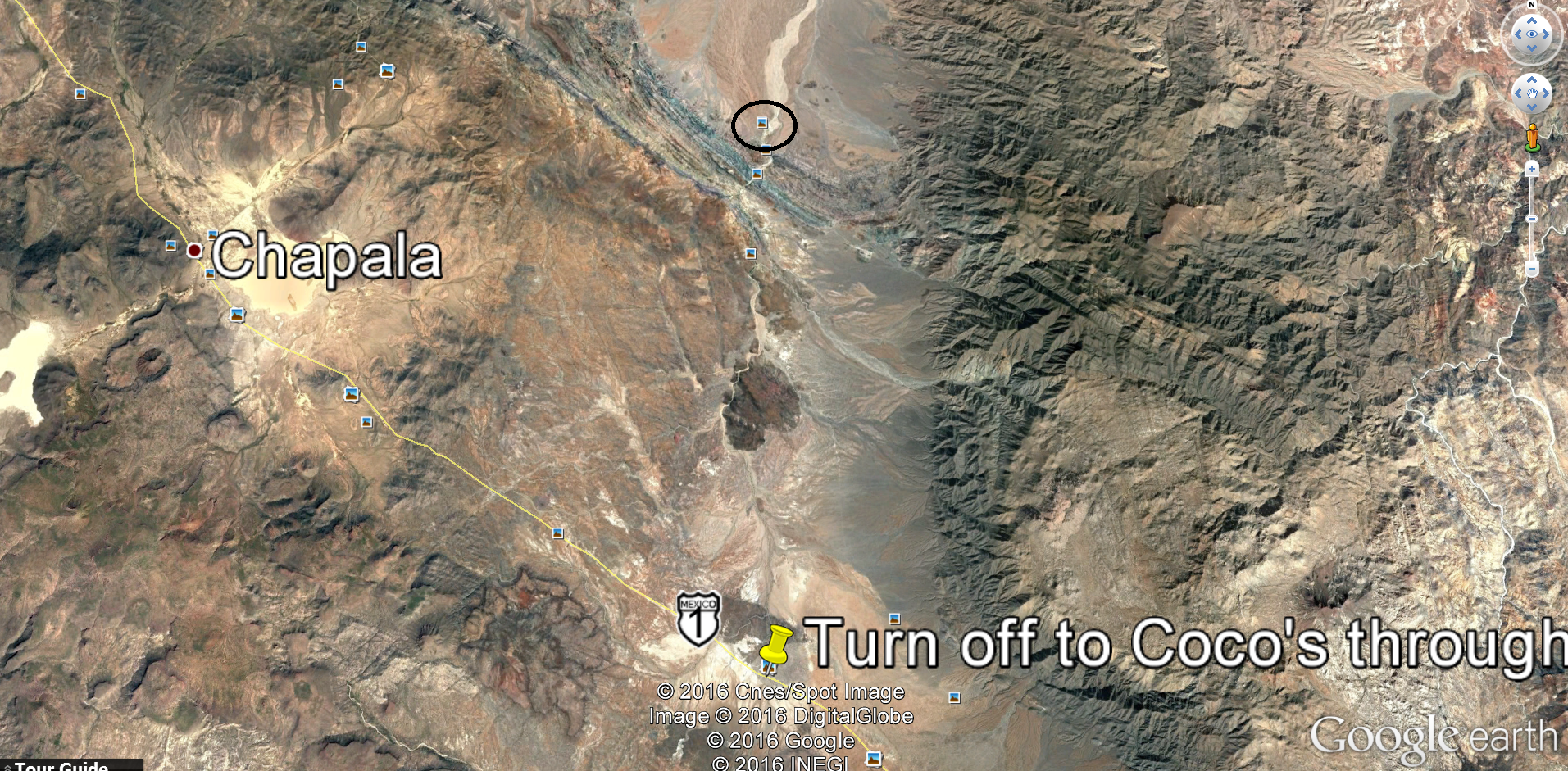
I was looking at the road on Google Earth. Does where I put the pin look like the turn off for the canyon? I put a black circle on a picture of what it says is the mission.


[Edited on 12-14-2016 by JZ]

[Edited on 12-15-2016 by BajaNomad]
View user's profile
David K
Honored Nomad
*********


Avatar


Posts: 64723
Registered: 8-30-2002
Location: San Diego County
Member Is Offline

Mood: Have Baja Fever

[*] posted on 12-14-2016 at 06:16 PM


The mission site is on the opposite side of the wash from the box in your black circle.

I can't tell what the turn off you have marked actually is, but that is not El Crucero or the water truck road. The water truck road is at Km. 251, 10 kms. north of El Crucero (Km. 261). It could be what you labeled.

Here are my Google Earth images of the area. I have noted the south end of Hwy. 5 at Laguna Chapala, The Water Truck road (from 1973 construction of Hwy. 1), El Crucero, the Fork where the water truck and original Calamajué south roads meet, and the mission site.


[Edited on 12-15-2016 by David K]


"So Much Baja, So Little Time..."

See the NEW www.VivaBaja.com for maps, travel articles, links, trip photos, and more!
Baja Missions and History On Facebook: https://www.facebook.com/groups/bajamissions/
Camping, off-roading, Viva Baja discussion: https://www.facebook.com/groups/vivabaja


View user's profile Visit user's homepage
David K
Honored Nomad
*********


Avatar


Posts: 64723
Registered: 8-30-2002
Location: San Diego County
Member Is Offline

Mood: Have Baja Fever

[*] posted on 12-14-2016 at 06:22 PM


See the AAA map... it shows the water truck road as 5.4 miles long. See my road log for my measured miles between Coco's and El Crucero... an easier point to meet your chase truck with ample safe parking area off the highway. The water truck road is at the top of a rise on Hwy. 1 and easy to miss seeing if not for the Km. 251 marker. El Crucero is marked as "Gate" on the map (gate no longer closed, rancho abandoned).


[Edited on 12-15-2016 by David K]


"So Much Baja, So Little Time..."

See the NEW www.VivaBaja.com for maps, travel articles, links, trip photos, and more!
Baja Missions and History On Facebook: https://www.facebook.com/groups/bajamissions/
Camping, off-roading, Viva Baja discussion: https://www.facebook.com/groups/vivabaja


View user's profile Visit user's homepage
JZ
Select Nomad
*******


Avatar


Posts: 10035
Registered: 10-3-2003
Member Is Online


[*] posted on 12-14-2016 at 08:24 PM


Got it, perfect thx.
View user's profile
David K
Honored Nomad
*********


Avatar


Posts: 64723
Registered: 8-30-2002
Location: San Diego County
Member Is Offline

Mood: Have Baja Fever

[*] posted on 12-14-2016 at 08:42 PM


I bet you guys have a great time!


"So Much Baja, So Little Time..."

See the NEW www.VivaBaja.com for maps, travel articles, links, trip photos, and more!
Baja Missions and History On Facebook: https://www.facebook.com/groups/bajamissions/
Camping, off-roading, Viva Baja discussion: https://www.facebook.com/groups/vivabaja


View user's profile Visit user's homepage

  Go To Top


All Content Copyright 1997- Q87 International; All Rights Reserved.
Powered by XMB; XMB Forum Software © 2001-2014 The XMB Group


"If it were lush and rich, one could understand the pull, but it is fierce and hostile and sullen. The stone mountains pile up to the sky and there is little fresh water. But we know we must go back if we live, and we don't know why." - Steinbeck, Log from the Sea of Cortez


"People don't care how much you know, until they know how much you care." - Theodore Roosevelt


"You can easily judge the character of others by how they treat those who they think can do nothing for them or to them." - Malcolm Forbes


"Let others lead small lives, but not you. Let others argue over small things, but not you. Let others cry over small hurts, but not you. Let others leave their future in someone else's hands, but not you." - Jim Rohn


"The best way to get the right answer on the internet is not to ask a question; it's to post the wrong answer." - Cunningham's Law


Thank you to Baja Bound Mexico Insurance Services for your long-term support of the BajaNomad.com Forums site.


Emergency Baja Contacts Include:

Desert Hawks; El Rosario-based ambulance transport; Emergency #: (616) 103-0262