JZ
Select Nomad

Posts: 14912
Registered: 10-3-2003
Member Is Offline
|
|
Anyone using a phone/tablet based GPS app in Baja
For trails?
I have Garmin and Cartografia maps, but hate the screen and UI of Garmin compared to the large touch screen of Android or iPhones.
Anyone use MotionX? Getting ready to check it out.
[Edited on 12-16-2016 by JZ]
|
|
|
JZ
Select Nomad
Posts: 14912
Registered: 10-3-2003
Member Is Offline
|
|
Been playing with MotionX for a couple hours. Wow. Really cool.
It gives you views from Google Earth and I was able to import points from my GE desktop pretty easily.

[Edited on 12-17-2016 by BajaNomad]
|
|
|
David K
Honored Nomad
Posts: 65587
Registered: 8-30-2002
Location: San Diego County
Member Is Offline
Mood: Have Baja Fever
|
|
The mission is across the arroyo from your pointed spot.
|
|
|
JZ
Select Nomad
Posts: 14912
Registered: 10-3-2003
Member Is Offline
|
|
Just compared the MotionX map around Calamje to the way points I set independently on GE and the look spot on.
You can highlight and cache the section you want for offline use. Thing is badass.
Still need to figure out how to cache GE views (but probably don't need them).
|
|
|
willyAirstream
Super Nomad
Posts: 1786
Registered: 1-1-2010
Member Is Offline
|
|
Motion X is the way to go. Back Country Navigator is a decent alternate for android, until Motion X comes out for android. I had to make foam filters
to keep the dust out of the tablet, btw.
|
|
|
edevart
Junior Nomad
Posts: 41
Registered: 3-30-2004
Location: Medio Camino
Member Is Offline
|
|
Yes, agree with the others. Motion X is great. I first started using it for work as a data gathering and navigation tool in the cell-coverage free
wilds of the desert SW, and now use it anytime I'm in the backcountry--work or play. For Baja one can download high detail satellite imagery for use
offline and out of cell range (meaning instead of relying on maps of varying quality, you can use recent satellite imagery--doesn't get more accurate
than that). And you can upload gpx files showing waypoints and routes...makes navigation a piece of cake if you spend some time before hand to draw
out some routes. I'm glad I didn't have it when I first started going to baja, or I probably wouldn't of had those I'm lost mishaps that led to new
discoveries, but I'm glad to have it now.
|
|
|
JZ
Select Nomad
Posts: 14912
Registered: 10-3-2003
Member Is Offline
|
|
Quote: Originally posted by edevart  | | Yes, agree with the others. Motion X is great. I first started using it for work as a data gathering and navigation tool in the cell-coverage free
wilds of the desert SW, and now use it anytime I'm in the backcountry--work or play. For Baja one can download high detail satellite imagery for use
offline and out of cell range (meaning instead of relying on maps of varying quality, you can use recent satellite imagery--doesn't get more accurate
than that). And you can upload gpx files showing waypoints and routes...makes navigation a piece of cake if you spend some time before hand to draw
out some routes. I'm glad I didn't have it when I first started going to baja, or I probably wouldn't of had those I'm lost mishaps that led to new
discoveries, but I'm glad to have it now. |
So far I''ve got:
- waypoints from Google Earth (GE) converted an imported over
- been able to download MotionX map regions
Haven't figured out how to download GE satellite images yet for offline use. How do you do that?
|
|
|
edevart
Junior Nomad
Posts: 41
Registered: 3-30-2004
Location: Medio Camino
Member Is Offline
|
|
Shhhhhh..... 
http://tlcfaq.com/main/2013/08/motion-x-custom-maps/
|
|
|
StuckSucks
Super Nomad
Posts: 2376
Registered: 10-17-2013
Location: Pacific Plate
Member Is Offline
|
|
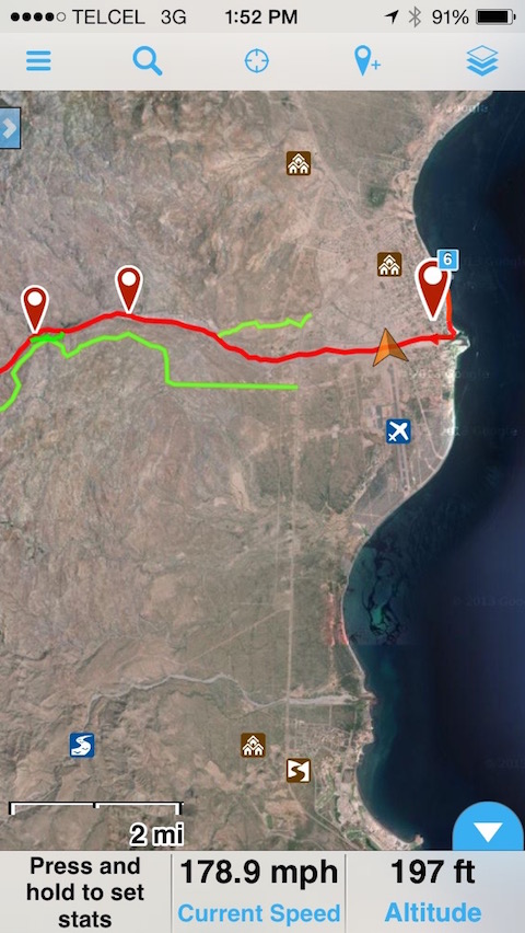
I use Gaia GPS. In this example, I've imported the Baja Sur 500 race course (red), plus chase access roads (green). Like other apps, I pre-downloaded
background maps for use offline.
The app also does a nice job as a trip calculator, laying down breadcrumbs, stats (max, average speeds, etc.), elevation profile, and tons of other
stuff.
BTW: that gold pointer was my location - I had just taken off from the Loreto airport and my altitude is 197 feet plus a respectable ground speed.
|
|
|
willyAirstream
Super Nomad
Posts: 1786
Registered: 1-1-2010
Member Is Offline
|
|
178.9 mph, you should have said you were pre running a class 11. Jajajaja
|
|
|
LaPlayaENC
Newbie
Posts: 12
Registered: 4-25-2016
Member Is Offline
|
|
I've been using my 2Gen iPad with a Bad Elf GPS dongle and Navmii app. Gave us great lines thru salt flats to San Juanico and over the road thru
Purisima.
|
|
|
carlosg
Senior Nomad
Posts: 504
Registered: 5-28-2012
Location: chula vista, ca
Member Is Offline
Mood: Just like in Baja: No Bad Days...
|
|
| Quote: Originally posted by willyAirstream | | Motion X is the way to go. Back Country Navigator is a decent alternate for android, until Motion X comes out for android. I had to
make foam filters to keep the dust out of the tablet, btw. |
Hi Willy and all other BajaNomads,
I'm a total inexperienced novice in the use of a GPS device, the closest I come to navigation is my street Google Maps directions... other than that
all I have is my Baja Almanac.
We're planning a trip to Tembabichi and from there to Agua Verde if possible on a Tacoma 06, 2WD early next spring, we have an
Android Galaxy S2 Tablet and will also have an Unlocked Galaxy S7 Edge by then, I would like to use both of them as a
GPS units for our trip and future ones as well.
I have a couple of questions for using BackCountry Navigator with my devices:
There's the regular version and then there's the PRO version ($11.99) of BackCountry Navigator, I plan on buying the PRO, any
differences that you may know offhand?
Do I need an external booster antenna to get the GPS Satellite connection (or boost it) or would the phone and/or tablet itself connect directly
to the satellite with no help out there in the middle of the boonies.
I have a Google Map and Google Earth Map for our trip, can I use the coordinates as way points from those maps?
Finding a reliable Baja Topo map to upload to BackCountry Navigator: do you have any recommendations?
Will I be able to see my "live" position on the screen and figure my way to my destination?
These are some facts about Android GPS from a blog on BackCountry Navigator that may be helpful for other novices like myself out
there:
http://backcountrynavigator.com/android-gps/
|
|
|
willyAirstream
Super Nomad
Posts: 1786
Registered: 1-1-2010
Member Is Offline
|
|
1. biggest difference is no ads. Some features are enhanced.
2. no external booster antenna needed. It will see the sat. where ever you are in Baja with only the internal antenna. I have used it inside the
Willys, the race car and a Ranger.
3. yes, and you can also import those maps, import a track you make or another person has made. I save screen shots from GE in my gallery as well as
fotos from baja almanac.
4. I gave up trying to find a decent scaleable topo map and just use google earth and google maps.
5. yes, with in 30 inches or so.
Suggestion, start using it now for trips to the grocery store and longer trips. Every time I use it I find more cool things it can do. Same for google
earth. My experience is with a older Asus tablet, but the S7 and S2 Tablet will work as good if not better.
btw, the 2017 race schedule will be out in a few days, make sure the Dos Mares 300 will not be going thru there or plan on watching it!
|
|
|
carlosg
Senior Nomad
Posts: 504
Registered: 5-28-2012
Location: chula vista, ca
Member Is Offline
Mood: Just like in Baja: No Bad Days...
|
|
Thanks Willy,
I'll purchase the BackCountry Navigator Pro and start fiddling around with it, you mentioned to use Google Maps or Earth: do you mean just downloaded
for off-line use... how?
|
|
|
willyAirstream
Super Nomad
Posts: 1786
Registered: 1-1-2010
Member Is Offline
|
|
Google explains it much better than I. See the FAQ area and youtube
|
|
|
JZ
Select Nomad
Posts: 14912
Registered: 10-3-2003
Member Is Offline
|
|
| Quote: Originally posted by carlosg | Thanks Willy,
I'll purchase the BackCountry Navigator Pro and start fiddling around with it, you mentioned to use Google Maps or Earth: do you mean just downloaded
for off-line use... how? |
You can use Google Earth to set way points. Then export them as a kml file. You can import them into your phone/tablet based gps app.
You need to cache the portion of maps you want to use off line. When you don't have cell service you won't be able to see the maps otherwise.
Here are two video's for MotionX that show how to do this stuff:
How to cache maps:
https://www.youtube.com/watch?v=Rj43-049uAE
How to import Google Earth / Google Maps kml file to MotionX
https://www.youtube.com/watch?v=SdoXOG2geIM&t=319s
[Edited on 12-24-2016 by JZ]
|
|
|
Pacifico
Super Nomad
Posts: 1299
Registered: 5-26-2008
Member Is Offline
|
|
Has anyone played with LeadNav?
I met a guy down in Baja using it and it looked pretty cool....
"Plan your life as if you are going to live forever. Live your life as if you are going to die tomorrow." - Carlos Fiesta
|
|
|
David K
Honored Nomad
Posts: 65587
Registered: 8-30-2002
Location: San Diego County
Member Is Offline
Mood: Have Baja Fever
|
|
I paired a DeLorme inReach Explorer with my Android phone and then downloaded the maps from Garmin's Earthmate app. I hope covers Baja in detail, so I
don't need cell service or WiFi for the GPS map. My cell phone now is a bigger-than-average screen GPS synced to the inReach device (I am using from a
friend). I will look forward to seeing how it works in Baja!
|
|
|
JZ
Select Nomad
Posts: 14912
Registered: 10-3-2003
Member Is Offline
|
|
| Quote: Originally posted by David K | | I paired a DeLorme inReach Explorer with my Android phone and then downloaded the maps from Garmin's Earthmate app. I hope covers Baja in detail, so I
don't need cell service or WiFi for the GPS map. My cell phone now is a bigger-than-average screen GPS synced to the inReach device (I am using from a
friend). I will look forward to seeing how it works in Baja! |
This doesn't sound like a good way to go. The apps are a better setup.
|
|
|
David K
Honored Nomad
Posts: 65587
Registered: 8-30-2002
Location: San Diego County
Member Is Offline
Mood: Have Baja Fever
|
|
I don't understand JZ what isn't good... I used an app (Earthmate).
|
|
|