| Pages:
1
2
3 |
bkman211
Newbie
Posts: 17
Registered: 5-3-2014
Member Is Offline
|
|
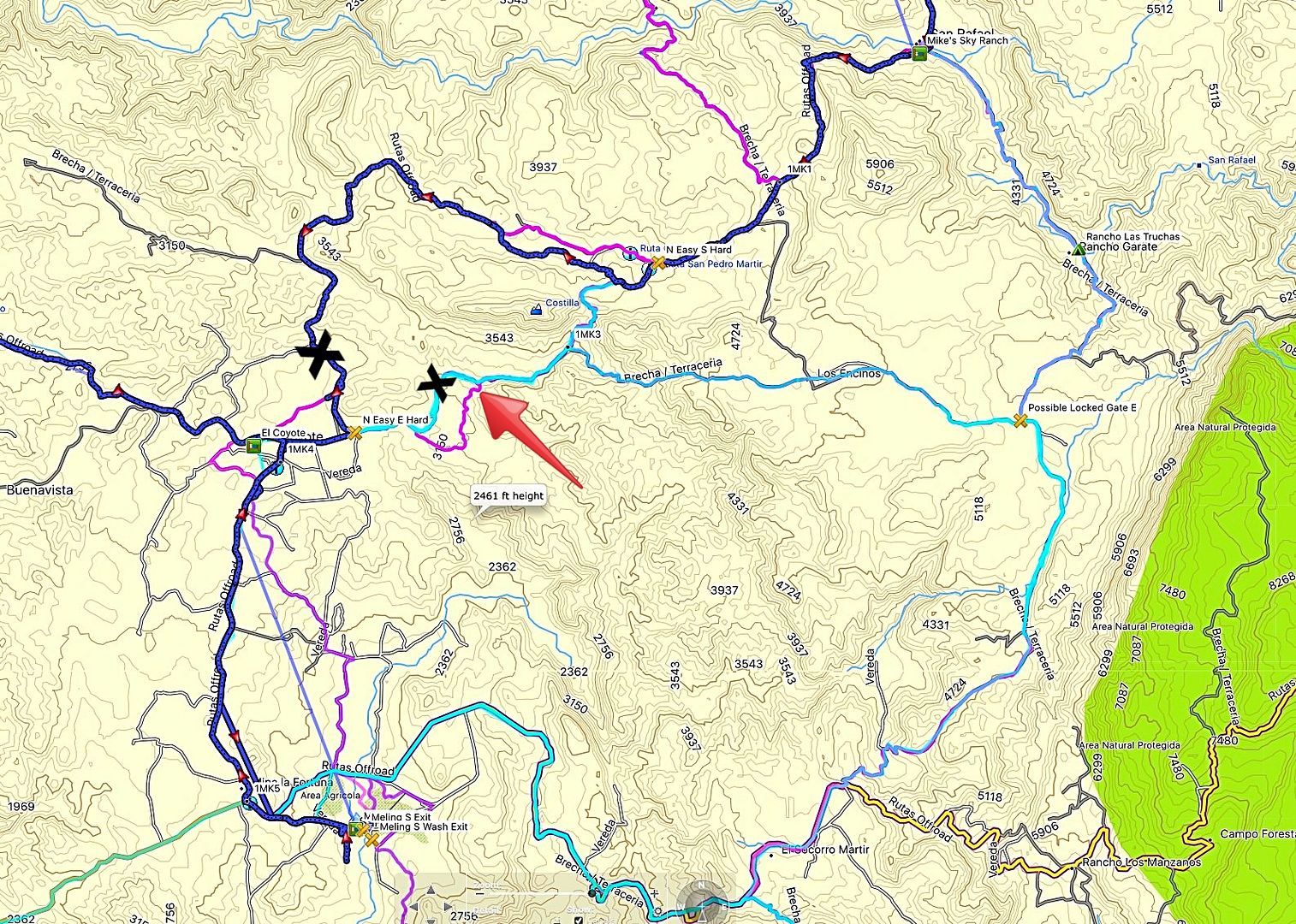
Just to be clear they have locked off the route to the north (dark blue line on map below) that bypasses the nasty rock climb/drop (1MK3 on map)?

[Edited on 12-1-2017 by bkman211]
[Edited on 12-1-2017 by BajaNomad]
|
|
|
David K
Honored Nomad
        
Posts: 65437
Registered: 8-30-2002
Location: San Diego County
Member Is Offline
Mood: Have Baja Fever
|
|
The place where my GPS showed the north road junction just east of El Coyote is now a plowed-over field and there is no road to be seen there (Where
your map says N easy E hard).
The next road closed and has been bypassed I put an X on, as well.
The red arrow points to where I turned around after my brake fail on the short, steep grade just before.

Interesting that your map has a couple of those wild, straight lines that I have been fighting with, too! .
[Edited on 12-1-2017 by David K]
|
|
|
John Harper
Super Nomad
   
Posts: 2289
Registered: 3-9-2017
Location: SoCal
Member Is Offline
|
|
Does anyone know if Rancho Las Truchas (Rancho Garate) is abandoned or occupied? I'm planning another trip out to Mike's in April to explore more of
the San Rafael, and was thinking of hiking from Mike's and possibly camping in that area one night. I got up to the falls last year, but wanted to go
much further up this next trip.
It's on the far right of your map off that medium blue line.
John
[Edited on 12-1-2017 by John Harper]
|
|
|
PaulW
Ultra Nomad
    
Posts: 3113
Registered: 5-21-2013
Member Is Offline
|
|
Here are some valid comments from a good friend.
Drove from Mikes in late May and found the lower road blocked. Took the traditional round (not sure which track). 3 jeeps with 33" tires and they
had no issues. Farmer at the bottom of the hill has blocked the road.
Also in late May two 2wd trucks and one Jeep and one VW beetle did the trip with no issues.
Also in This October they found the same blocked lower road and successfully made the trip to Coyote. His comment "Now the road is fine".
Your experience may differ???
|
|
|
bajatrailrider
Ultra Nomad
    
Posts: 2520
Registered: 1-24-2015
Location: Mexico
Member Is Offline
Mood: Happy
|
|
Not sure where your talking about Paul but if lower road Mike to Coyote. In Oct open not hard. As from lower road to Coyote all graded For new water
project in canyon and rancho in trees. That route blocked closed by Melings. I'm only specking of recent closing of road. As I said only route I know
of from Coyote High road Moto,Jeep, ATV. Friend of mine did try High road in fully Modded VW off road rig with 2350 motor. No run at hill climb . So
he could not make it. We will not go Coyote this week but next week yes 2 to 3 days. Planning on making new trail.
|
|
|
PaulW
Ultra Nomad
    
Posts: 3113
Registered: 5-21-2013
Member Is Offline
|
|
Agree to many roads. Like BajaTrailrider I will just have to go there and drive and make GPS tracks.
My friend probably took the usual road, but what about the others? Pretty sure he took the left at the Y where the new easy road that the Coyote
people made. It is the easy one that he said was closed which goes down the hill to a graded road leading to/from Coyote along valley to another large
rancho.
|
|
|
| Pages:
1
2
3 |

