| Pages:
1
2
3
4 |
David K
Honored Nomad
        
Posts: 65412
Registered: 8-30-2002
Location: San Diego County
Member Is Offline
Mood: Have Baja Fever
|
|
Thanks, Kevin!
It was a nice drive, pretty easy all the way from Hwy. 3 to Hwy. 2. Big puddles, many unavoidable were on the road north of Laguna Hanson.
The pine trees are a different scenery of long Baja drives as I am more used to boojum trees and cardón cacti!
|
|
|
David K
Honored Nomad
        
Posts: 65412
Registered: 8-30-2002
Location: San Diego County
Member Is Offline
Mood: Have Baja Fever
|
|
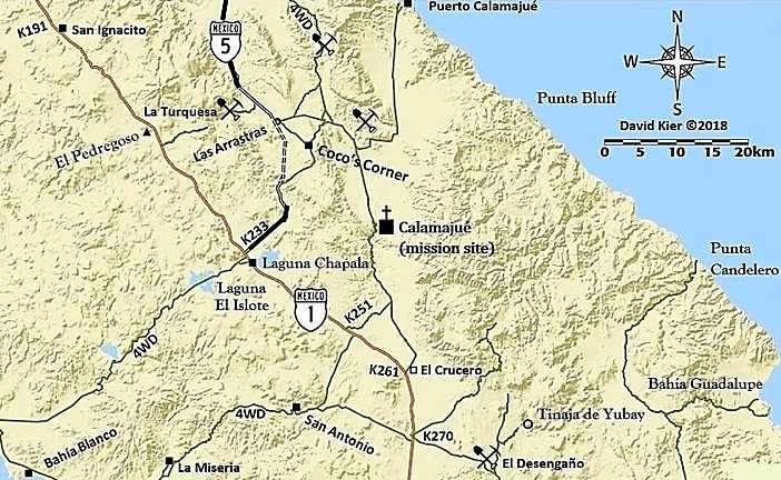
Revised map for the south end of Hwy. 5 changes:

I left the Coco's bypass (new highway route) as dashed lines since it is unfinished and the south detour to the old route is pretty rough for non-4WD
vehicles, even though it is less than a mile long. As it is now, most traffic should exit the new roadbed at Las Arrastras and continue via Coco's
Corner. The 3.0 miles of 4.5 miles of paved road in the Chapala Valley is also unusable to most vehicles because of the big dirt berm placed at the
south end (1 mile from Hwy. 1) with a short deep silt detour to the rest of the road. None-the-less, the paved road is there awaiting the job to be
completed... someday!
|
|
|
David K
Honored Nomad
        
Posts: 65412
Registered: 8-30-2002
Location: San Diego County
Member Is Offline
Mood: Have Baja Fever
|
|
Estimated Kilometer #s and current road log south of Km. 168
Using the newest sections of road where possible south of the first detour sign at Km. 167.5.
KM. 168 The last kilometer sign noted, 21 kms. south of Gonzaga Pemex, and 1/2 km. south of detour sign, in place since 2014.
Mile 0.0 End of paving, Km. 168.5+ [Km. figures south from here are estimated along new highway]
Mile 0.4 [Km. 169.5] Another detour road down to the right to the older road.
Mile 0.9 [Km. 170+] On a very high bridge. Seen from older route below and to the west.
Mile 1.7 [Km. 171.5] Detour road/old road crosses new. All traffic now uses the new road from here south.
Mile 2.6 [Km. 173+] Road west to La Turquesa Canyon (not driven this trip).
Mile 4.6 [Km. 176] Detour route forks left to the old road via Coco's Corner. Most traffic still uses. Log continues on new highway route.
Mile 4.8 [Km. 176.5] Las Arrastras Bridge. See caves and large arrastra (gold ore grinding wheel) down to the east of the highway. New road bed heads
upslope, cutting through ridges. Road base never completed, many rocks to dodge and rain erosion for apparent abandonment of the project.
Mile 9.4 [Km. 183.5+] Leave new roadbed (which ends ahead at top of the mountain cut) on detour/access road going down 0.9 mi. to the older road,
south from Coco's Corner. This is an SUV/truck/4x4 style road.
Mile 10.3 On old road, damaged construction sign and orange cones are all that mark this junction.
Mile 11.1 Construction camp, parked equipment, almost no activity.
Mile 11.7 [Km. 186] New highway will junction about here when completed, coming over the mountain from Mile 9.4 above. This will cut approx. 1 mile
from this logged distance when open.
Mile 13.3 [Km. 188.5] Pavement begins, Aug. 16, 2018.
Mile 14.8 [Km. 191] Detour right, off the pavement to the older road, for most vehicles.
Mile 17.8 [Km. 195.5+] End of pavement, large sand pile on road, only deep dust (silt) tracks from here to old (detour) road. 1 mile to Highway 1.
Mile 18.8 [Km. 197+] Highway 1/ Laguna Chapala/ Km. 200 sign for Hwy. 5 end. I will estimate the final kilometer will be reduced to 197 because with
the small detour it is 199 kms and the route will cut about 2 kilometers off when it is pushed through to the canyon.
[Edited on 9-5-2018 by David K]
|
|
|
norte
Super Nomad
   
Posts: 1163
Registered: 10-8-2008
Member Is Offline
|
|
Why bump this thread. With all the storm damage, it is more than sightly out of date.
|
|
|
David K
Honored Nomad
        
Posts: 65412
Registered: 8-30-2002
Location: San Diego County
Member Is Offline
Mood: Have Baja Fever
|
|
Thanks for asking. There is much more to this report than the portion of Hwy. 5 that was damaged, and that was in October, 2 months after I was there.
This report covers all of Hwy. 3, both of them as well as both roads to Laguna Hanson. Perhaps you missed all that focussing on the small part of my
post that covered where the highway was damaged.
I bump up posts when I get a u2u request from people seeking photos or data that I have. Do you have a trip report to help Nomads plan a trip you can
share?
Happy Festivus!
|
|
|
David K
Honored Nomad
        
Posts: 65412
Registered: 8-30-2002
Location: San Diego County
Member Is Offline
Mood: Have Baja Fever
|
|
Here on Nomad, the Photobucket images are no longer sized to fit the page and have watermarks, but not where I also shared the trip report on Tacoma
World... odd?? I have been paying to prevent that.
Here is the trip report, as it should appear: https://www.tacomaworld.com/threads/trip-8-aug-2018-new-hwy-...
|
|
|
| Pages:
1
2
3
4 |
|

