John M
Super Nomad
   
Posts: 1924
Registered: 9-3-2003
Location: California High Desert
Member Is Offline
|
|
Question for our Mulege OHV friends
This route has been discussed in the past but recent info would be appreciated.
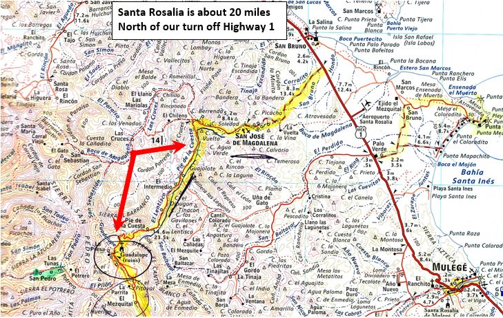
Proposed route for early November - south of Santa Rosalia about 20 miles is a turn west going through San Jose Magdalena. About 5 miles west of San
Jose Magdalena a road ventures south. On the attached map it is identified as Pie de la Cuesta, taking us to the site of Guadalupe de Huasinapi. From
there we may head to the Pacific via Arroyo San Raymundo.
My question - is Pie de la Cuesta passable for 4x4 trucks (not full size). Are you aware of recent attempts on that route?
John M

|
|
|
John M
Super Nomad
   
Posts: 1924
Registered: 9-3-2003
Location: California High Desert
Member Is Offline
|
|
Follow up, for DK
David is the road I'm referring to the one you wrote about in your post of August 14?
"We made a full loop that day going in from the road that heads on across to the Pacific side and coming out on the recently reopened canyon road
through San José de Magdalena that was destroyed in 2014."
John M
|
|
|
David K
Honored Nomad
        
Posts: 65436
Registered: 8-30-2002
Location: San Diego County
Member Is Offline
Mood: Have Baja Fever
|
|
Yes.
Steep but passable going in. 4WD advised on the grade.
|
|
|
David K
Honored Nomad
        
Posts: 65436
Registered: 8-30-2002
Location: San Diego County
Member Is Offline
Mood: Have Baja Fever
|
|
Santa Rosalía is Km.195 and the paved road to San José de Magdalena is Km.168+. That's 27 kms. or 17 miles.
The road west to the ranches along the aqueduct for La Magdalena is Km.162+.
The paved road East to that Palo Verde airport is Km 161+.
The dirt road west to San Borjitas is Km.156.
These are all in the Nomad Kilometer List, I believe?
|
|
|
MulegeAL
Nomad
 
Posts: 299
Registered: 8-25-2009
Location: PDX/Mulege
Member Is Offline
|
|
JM, did that route 3 or 4 times last season. Rocks. 4wd on the climbs. Last chance for cerveza is San Jose de Magdalena.
If you turn west to the coast, that is about 50 miles of rock and sand, then south to San Juanico. That will be a long day.
There is a "shortcut" to the left over the top before the coast turn, is rough, we do it with bikes no problema. Saves about 7 miles.
Have fun!
|
|
|
advrider
Super Nomad
   
Posts: 1920
Registered: 10-2-2015
Member Is Offline
|
|
MulegeAL, any chance you have tracks for this ride, or any other Nomads?
|
|
|
DouglasP
Nomad
 
Posts: 322
Registered: 6-23-2018
Member Is Offline
Mood: Goat hunter.
|
|
I've done this loop multiple times just last spring. Done on dirt bikes and in the truck and in the side by side. Great fun. I will post up some pics
and tracks tomorrow.
I like beer, better than most people.
|
|
|
David K
Honored Nomad
        
Posts: 65436
Registered: 8-30-2002
Location: San Diego County
Member Is Offline
Mood: Have Baja Fever
|
|
John, on your map above, the ranch where you get the guide and buy a permit for San Borjitas is listed as 'La Tinaja' The road literally end in the
ranch front yard with signs advertising the cave tour. The cave is called 'San Borja' on the map (near the bottom edge). There is no ranch there, just
a parking and rest area. There is a locked gate so you must use a guide to get there. It was a very reasonable price, I believe.
|
|
|
MulegeAL
Nomad
 
Posts: 299
Registered: 8-25-2009
Location: PDX/Mulege
Member Is Offline
|
|
I used to, but lost them all when I slammed into a goat down there 2 years ago. The GPS went flying (so did I), never found it. I have a new GPS
with better mount for coming season.
Contact me when you get down there, I should be around in Dec or so, we can go pound sand/rocks. I don't recc this ride for big twins. Hell, I don't
recc any of the interior rancho roads for big twins mainly because of the sand & rocks, singles rule!
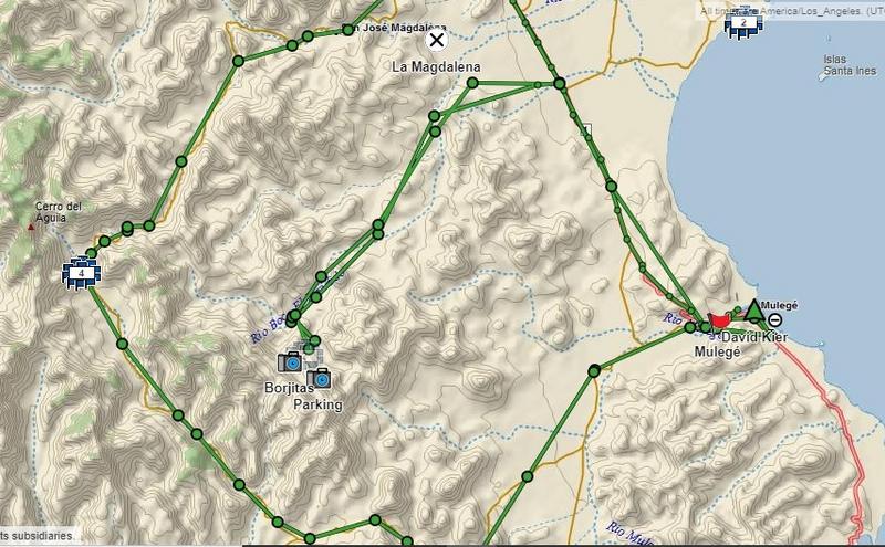
This route is pretty easy to find. Take a map or copy, your tracks will look just like the stuff DK posts. That loop is 96 miles around from Mulege.
|
|
|
David K
Honored Nomad
        
Posts: 65436
Registered: 8-30-2002
Location: San Diego County
Member Is Offline
Mood: Have Baja Fever
|
|
Quote: Originally posted by MulegeAL  |
I used to, but lost them all when I slammed into a goat down there 2 years ago. The GPS went flying (so did I), never found it. I have a new GPS
with better mount for coming season.
Contact me when you get down there, I should be around in Dec or so, we can go pound sand/rocks. I don't recc this ride for big twins. Hell, I don't
recc any of the interior rancho roads for big twins mainly because of the sand & rocks, singles rule!
This route is pretty easy to find. Take a map or copy, your tracks will look just like the stuff DK posts. That loop is 96 miles around from Mulege.
|
Some of my inReach track from last May (4 is Mission Guadalupe):

|
|
|
JZ
Select Nomad
      
Posts: 13942
Registered: 10-3-2003
Member Is Online
|
|
Here is the route to Guadalupe. And the Arroyo San Raymund trail. Only part that is missing is the cut down from Guadalupe to the San Raymund trail.
I have that as part of another track. You can see it easily on GE though.
Attachment: Rt Arroyo San Raymund Trail.kmz (40kB)
This file has been downloaded 324 times
Attachment: Rt MX 1 to Mission Guadalupe.kmz (4kB)
This file has been downloaded 282 times
|
|
|
JZ
Select Nomad
      
Posts: 13942
Registered: 10-3-2003
Member Is Online
|
|

|
|
|
chuckie
Elite Nomad
     
Posts: 6082
Registered: 2-20-2012
Location: Kansas Prairies
Member Is Offline
Mood: Weary
|
|
JZ! That's so cool to see posts like that! I wandered around that real estate quite a bit,without a clue as to where I was or where I was going, Nice
to be able put it into some kind of perspective....Thanks...
|
|
|
BajaNomad
|
Thread Moved
10-30-2019 at 10:53 AM |

