DeepSlack
Newbie
Posts: 5
Registered: 12-16-2015
Member Is Offline
|
|
8/19 - 8/26: Awesome + Failure
Hello all. My friend and I headed south last week for the first time since Covid for some much needed exploring, surfing and fishing. There was a
small bump in swell forecast due to Hurricane Genevieve, and we wanted to get further south and explore something new. I've been surfing the same set
of 7 Sisters for many years (Wall, Negra, Alejandros, Cardon, Maria), but only in winter as they are all blocked from south swells. However, the
surfer's guide states that Punta Canoas is open to south swells. So we decided to give it a go, neither of us having been to this particular spot
before. After a late start and a mostly pleasant and uneventful crossing from San Diego @ Otay, we stopped for an overnight @ 4 Casas where we got
some fun, mellow surf, before heading south the morning of 8/20.
Took a turnoff north of Catavina and drove 2 bumpy hours west toward Punta Canoas. Stunning scenery which made the drive already worth it. Eventually
came across a fishing village after seeing a panga with a sign that read "Punta Canoas" and located what I am fairly certain was the landmass of Punta
Canoas proper. I could see the point and the south swell wrapping in nicely. Problem was that I was seeing it from a bluff about 300 feet high. We
checked several other bluffs to the north and south, and none had any signs whatsoever of camping or access to the surf several hundred feet below. We
did find access to the ocean via a boat ramp used by the fisherman, but it was a small, steep cobblestone beach with no room for camping and far from
the point I had spotted from the bluffs above. Headed back to the fishing village with my kindergarten Spanish, and surmised that gringos didn't camp
around here, but to the south about 5km. So we headed southeast back inland a small bit, until we saw a track heading west and north toward the ocean.
Took that and came across another small fishing village called Puerto Canoas. I recognized that this was Puerto rather than Punta Canoas, and assumed
we were in the wrong spot. I stopped to speak with one of the villagers, and he stated that he knew nothing of camping and surfing if we continued
north on that coast track, but that many gringos camped just a short way south at a spot he called Mujeres. We thanked him, gave his kids some
chocolate bars and trail mix and turned around. We really wanted to find Canoas though, so instead of following his suggestion to head south we headed
north again, just in case we might have missed a track. We did find some tracks but again they either degraded into nothing or terminated at high
bluffs with no access to the ocean. We eventually bumped into a fisherman in a truck and flagged him down for some advice. While sharing a cold Tecate
with him, he also told us that most gringos he was aware of camped to the south, at a spot called Mujeres, just as the other fisherman had said. By
this point we were losing light and were quite road weary, so we decided to head south.
We ended up at a long straight beach that was a mix of cobblestone and sand, with a small outcropping of land to the north, just as the sun was
setting. It was a very pretty spot and there were obvious signs of camping, but definitely not a point break. Surf was almost non-existent and walled
out, so I surmised we had gone too far south for south swells to get in.
We had a great day of 4x4 exploring, chatting with villagers, and witnessing truly stunning vistas. We enjoyed a moonless, clear night illuminated by
a billions star serenaded by howling coyotes in the near distance. So f'ing what. We got skunked. We skunked ourselves. We failed. The next morning
the surf was even smaller, and we bailed. We did make more attempts that next morning to find the fabled f'ing point break that breaks on south
swells, but we never found a place to camp or access multiple, beautiful point breaks except for that boat ramp.
We ended up moving on to spots more familiar, and had a great trip over the remaining few days. But I remain bummed that we never found the
camping/surfing spot for Punta Canoas. It wasn't for lack of trying.
I'm writing all this in the hopes that some Baja enthusiast who know where to camp for the surf spot known as Punta Canoas might private message me
some advice. I can provide GPS coordinates and photos (via private message) of where I went, and perhaps someone can tell me "dude, it was that dirt
track right there" or "man, you were way the hell off." I'll be eternally grateful and will reserve you a spot on my next trip, gas & beer on me.
Seriously.
Thanks for your time.
|
|
|
mtgoat666
Platinum Nomad

Posts: 21150
Registered: 9-16-2006
Location: San Diego
Member Is Offline
Mood: Hot n spicy
|
|
Not cool to share gps tracks. You must find it on your own. You must work for it to appreciate it. Hint: easy to see possible tracks on google
earth.
Woke!
Hands off!
“Por el bien de todos, primero los pobres.”
“...ask not what your country can do for you – ask what you can do for your country.” “My fellow citizens of the world: ask not what America
will do for you, but what together we can do for the freedom of man.”
Pronoun: the royal we
|
|
|
David K
Honored Nomad
Posts: 65586
Registered: 8-30-2002
Location: San Diego County
Member Is Offline
Mood: Have Baja Fever
|
|
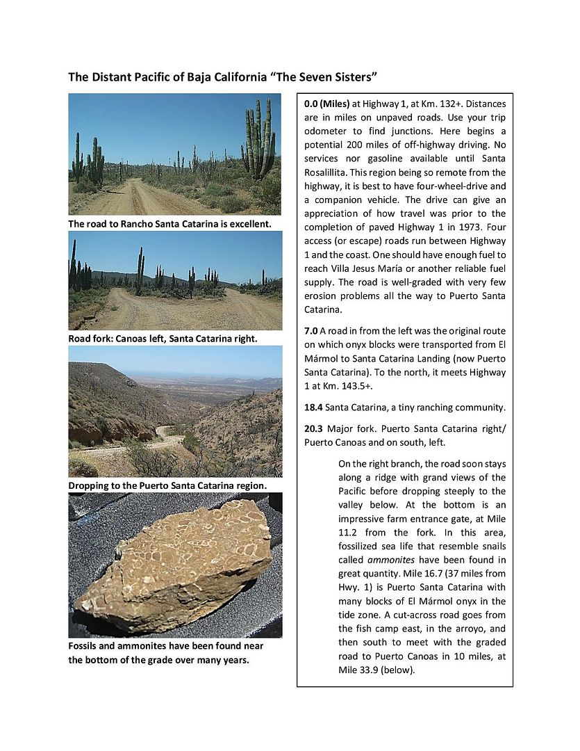
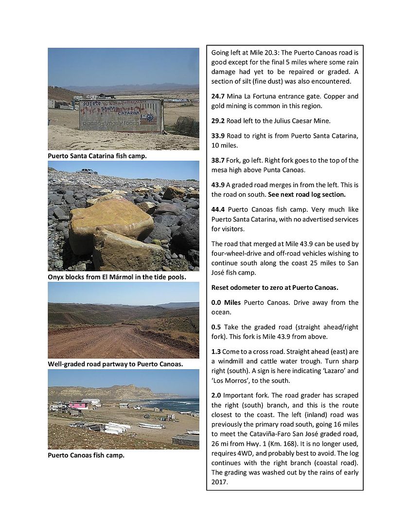
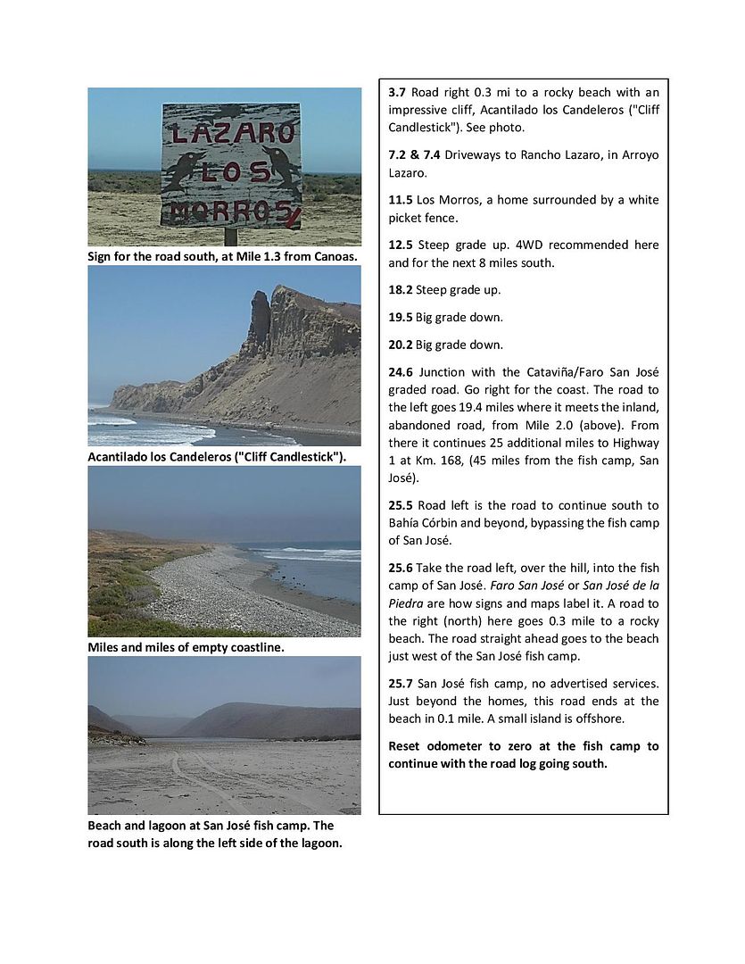
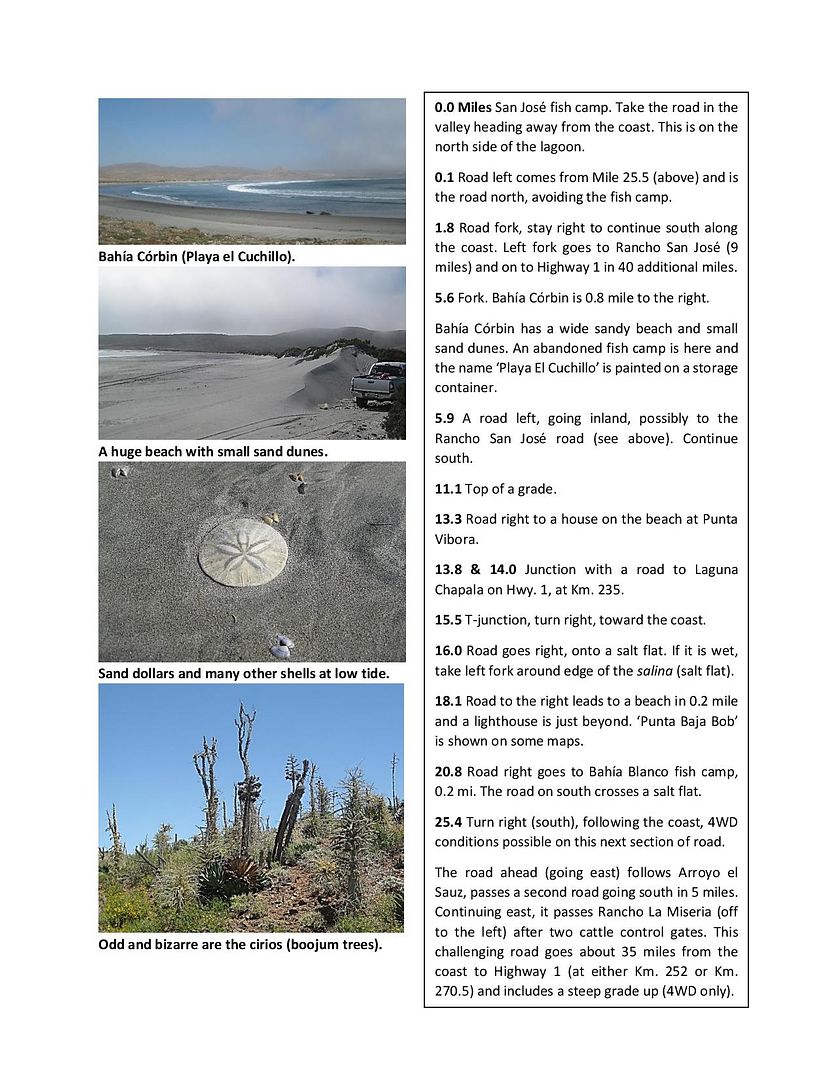
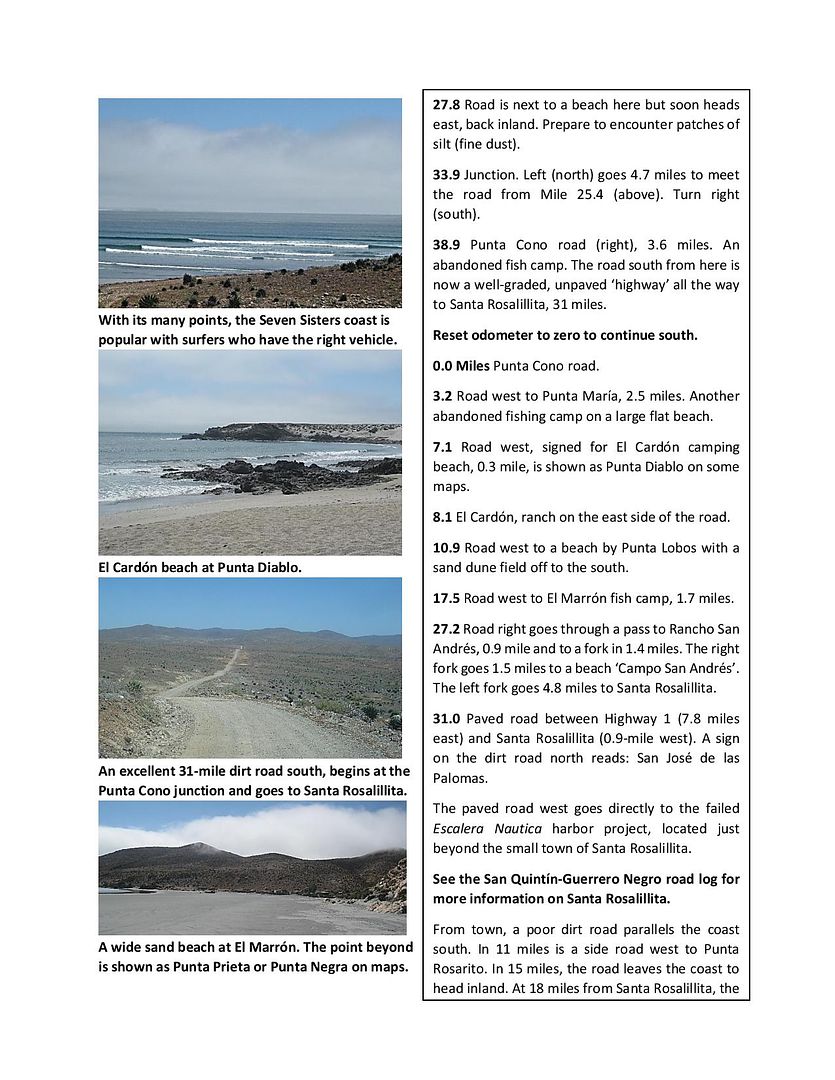
Lots to explore and enjoy in the region.
Welcome DeepSlack... Ignore those who have no courtesy here.
I traveled the area (and much of Baja) in 2017 gathering data and GPS points for Baja Bound Insurance. A road guide is on hold pending the end of this
virus. I have made much of the (pre-publication) guide available to my Nomad friends. Here is the section that includes the roads along Seven Sisters:
http://forums.bajanomad.com/viewthread.php?tid=91898
One of my maps to show the roads:
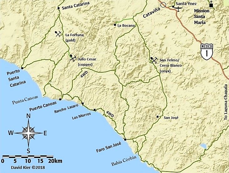
[Edited on 8-29-2020 by David K]
|
|
|
bajatrailrider
Ultra Nomad
Posts: 2555
Registered: 1-24-2015
Location: Mexico
Member Is Offline
Mood: Happy
|
|
welcome DS total ignore pendio goat just a dum drunk. welcome thank you for great story.
|
|
|
del mar
Banned
Posts: 1057
Registered: 7-23-2016
Location: the cantina of course
Member Is Offline
Mood: lil' fuzzy
|
|
catch any fish?
|
|
|
DeepSlack
Newbie
Posts: 5
Registered: 12-16-2015
Member Is Offline
|
|
Thanks for the greetings, everyone.
David K thanks for the response and for sharing your work. I look forward to buying a copy once published. I use Baja Bound for my insurance so I hope
they'll send some sort of announcement upon publication. What a fun project (and a lot of "work"). I was definitely at Punta Canoas, and spent many
hours driving around between there & Puerto Canoas to the south, and further south still to a spot the locals call "Mujeres". Unfortunately I
wasn't able to find a way down do the point other than the boat ramp, or a nice place to camp other than way high up on the bluffs.
del mar unfortunately the fishing wasn't so good for us. I'm not much of an angler, but our fishing was as luckless as our scoping a new point. Caught
a trigger fish (?) using frozen squid. We cut that up for bait, which then got us 3 more triggers and a puffer. Threw them all back. We did score a
bunch of clams that we ate in various ways. This was on the gulf side (LA Bay). It was hellishly hot, but great snorkeling.
Offer of a free ride and beer still stands for anyone who can describe where the heck I should have camped/surfed for Punta Canoas.
Thanks.
|
|
|
TMW
Select Nomad
Posts: 10659
Registered: 9-1-2003
Location: Bakersfield, CA
Member Is Offline
|
|
I'm not a surfer but this may help you find Punta Canoas.
The village is at 29-26.900x115-10.880 and the ocean is about 1/4 mile south thru a canyon type drive to 29-25.900x115-10.880. If you look on Google
Earth you can get an ideal of the locations. You really should take the turn off from Hwy 1 at KM132 at Guayaquil. It's marked for Puerto Santa
Catarina. If needed a GPS track can be made using Google Earth. About 20 miles from Hwy 1 and about 2 miles past Rancho Santa Catarina is a fork in
the road go left. They both will look like good graded roads. The road getting in can be confusing as you get close.
As to camping just find a spot that suits your taste. It's been a few years since I've been there so I don't remember what the beach area looks like.
The beaches north of the San Jose area where the main road comes out from Catavina to the ocean are mostly rocky and to the south they are sandy.
[Edited on 9-14-2020 by TMW]
|
|
|
David K
Honored Nomad
Posts: 65586
Registered: 8-30-2002
Location: San Diego County
Member Is Offline
Mood: Have Baja Fever
|
|
Text Quote: Originally posted by TMW  | I'm not a surfer but this may help you find Punta Canoas.
The village is at 29-26.900x115-10.880 and the ocean is about 1/4 mile south thru a canyon type drive to 29-25.900x115-10.880. If you look on Google
Earth you can get an ideal of the locations. You really should take the turn off from Hwy 1 at KM132 at Guayaquil. It's marked for Puerto Santa
Catarina. If needed a GPS track can be made using Google Earth. About 20 miles from Hwy 1 and about 2 miles past Rancho Santa Catarina is a fork in
the road go left. They both will look like good graded roads. The road getting in can be confusing as you get close.
As to camping just find a spot that suits your taste. It's been a few years since I've been there so I don't remember what the beach area looks like.
The beaches north of the San Jose area where the main road comes out from Catavina to the ocean are mostly rocky and to the south they are sandy.
[Edited on 8-29-2020 by TMW] |
|
|
|
|


