4x4abc
Ultra Nomad
    
Posts: 4452
Registered: 4-24-2009
Location: La Paz, BCS
Member Is Offline
Mood: happy - always
|
|
old Las Venecas Photos post
David had posted:
"Here is a picture of Cerro las Venecas and photos at Arroyo las Venecas (incl. Paulina, Neal Johns, Desert Rat, and El Camote: http://davidksbaja.com/van1/page8.html (if you click on the previous page, you will see some of the giant cardons in Valle La Bocana/ Llanos de
San Pedro). Photos taken July 4, 2001."
Where do I find Arroyo las Venecas?
Harald Pietschmann
|
|
|
David K
Honored Nomad
        
Posts: 65383
Registered: 8-30-2002
Location: San Diego County
Member Is Offline
Mood: Have Baja Fever
|
|
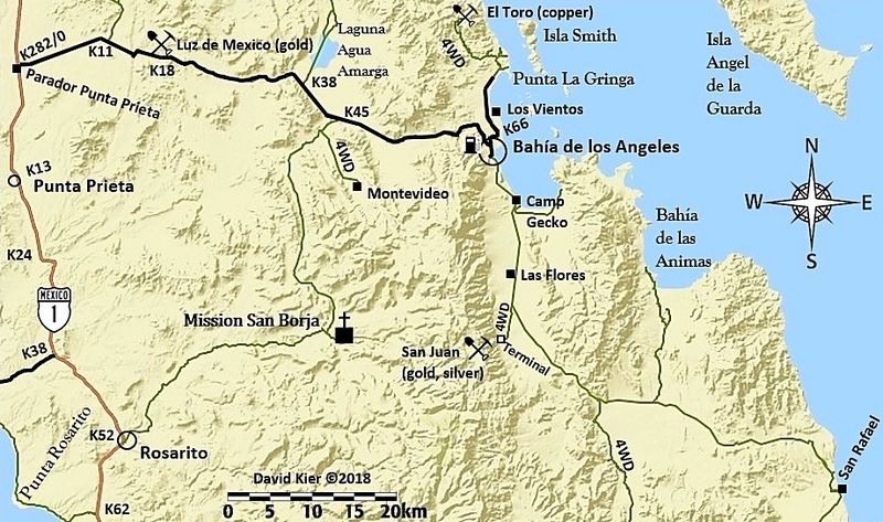
That web page should say... We were on the "Green Door Road" (the old road down to Valle la Bocana aka San Pedro). Las Venecas was just south of the
new road to Bahía San Rafael/ Punta San Francisquito and just north of Paredones...
On this map, north of the 4WD where the road goes towards the canyon briefly...

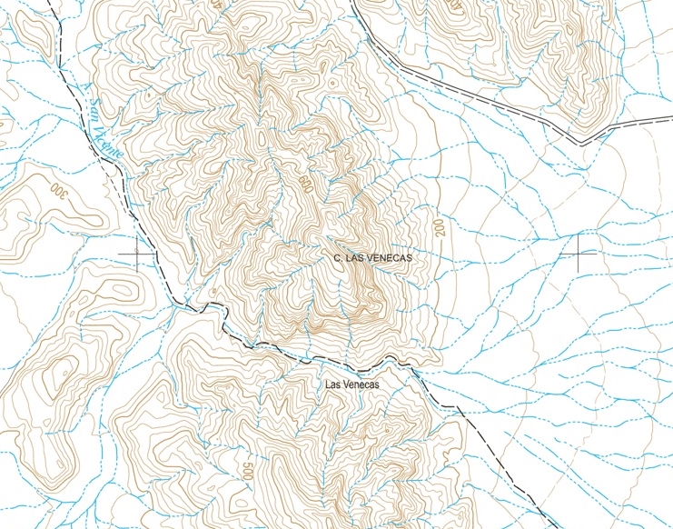
Close up on topo (does not show the Green Door road north of the canyon to the graded road...

[Edited on 2-21-2021 by David K]
|
|
|
AKgringo
Elite Nomad
     
Posts: 6276
Registered: 9-20-2014
Location: Anchorage, AK (no mas!)
Member Is Online
Mood: Retireded
|
|
Harald, that link doesn't work for me. Good to see you post here again, I hate it when people go away.
[Edited on 2-21-2021 by AKgringo]
If you are not living on the edge, you are taking up too much space!
"Could do better if he tried!" Report card comments from most of my grade school teachers. Sadly, still true!
|
|
|
David K
Honored Nomad
        
Posts: 65383
Registered: 8-30-2002
Location: San Diego County
Member Is Offline
Mood: Have Baja Fever
|
|
Quote: Originally posted by AKgringo  | Harald, that link doesn't work for me. Good to see you post here again, I hate it when people go away.
[Edited on 2-21-2021 by AKgringo] |
Right... since DavidKsBaja became VivaBaja, years ago!
Here is the link: http://www.vivabaja.com/van1/page8.html
|
|
|
David K
Honored Nomad
        
Posts: 65383
Registered: 8-30-2002
Location: San Diego County
Member Is Offline
Mood: Have Baja Fever
|
|
A couple pages after, Harald would have seen this:
GPS DIRECTIONS: L.A. BAY & SOUTH (WGS 84)
Casa Diaz, Bahia de los Angeles: N28°56.77' W113°33.55'
Camp Gecko, south of town: N28°54.05' W113°31.73'
Las Flores (jail house): N28°49.10' W113°31.77'
Jcn. with old road south: N28°40.77' W113°25.45'
Arroyo to Las Venecas: N28°39.40' W113°25.86'
Site of Paredones, Jesus' ranch: N28°36.81' W113°24.59'
Road ahead to La Bocana & San Pedro, turn sharp left (east): N28°28.40' W113°23.47'
We turn right, off road here: N28°28.01' W113°20.46'
Tinaja de Santa Maria: N28°26.09' W113°20.02'
We hiked a half mile further, but this was not the old mission era site.
|
|
|
4x4abc
Ultra Nomad
    
Posts: 4452
Registered: 4-24-2009
Location: La Paz, BCS
Member Is Offline
Mood: happy - always
|
|
you mention Mike Humphreville and his hut at Las Cuevitas. What is called Las Cuevitas? The arroyo? The point? What?
Harald Pietschmann
|
|
|
David K
Honored Nomad
        
Posts: 65383
Registered: 8-30-2002
Location: San Diego County
Member Is Offline
Mood: Have Baja Fever
|
|
Mike called it that for the little caves along the way.
|
|
|

