David K
Honored Nomad

Posts: 65537
Registered: 8-30-2002
Location: San Diego County
Member Is Offline
Mood: Have Baja Fever
|
|
THE SAN FELIPE SOUTH CAMPOS KILOMETER LIST
Updating the San Felipe South Campos Kilometer List using Google Earth Street View of May 2022.
THE SOUTH CAMPOS KILOMETER LIST (let's keep it updated with name changes or additions, etc.)
LIST Under Construction 1-10-23
Updating using Google Earth Street View of May 2022 (and your input):
Km. 0 Airport Road (6.1 miles from San Felipe traffic circle)
Km. 1 La Hacienda
Km. 4+ Tortugas Bay Resort
Km. 4.5 Aquamarina Condotel & Villas Km. 4.5+ S.F. Diamante Residencial
Km. 6.5+ Residence "Camping" (El Faro Beach)
Km. 8.5+ Villa Marina RV Park (camping)
Km. 8.5+ Del Cielo a la Playa
Km. 9+ Campo Lobo
Km. 9+ Misión Los Sahuaros
Km. 9.5+ Campo Mora (camping)
Km. 11 La Jolla del Mar/Villas Alejandrinas
Km. 12+ Punta Estrella Beach (camping)
Km. 14+ Valle de los Gigantes
Km. 15.5+ Pancho's (? no sign)
Km. 16.5+ "Oh Sh#! Dip"
Km. 17 Rancho Los Potrillos (?) + Chenowth sign
Km. 20.5+ Rancho Percebu & Chenowth Legacy Lodge main entrance
Km. 26+ Shell Island access road (4WD)
Km. 31 Bahía Santa María/ San Carlos/ Playa Hermosa/ La Misión
Km. 31.5 Baja Beach Resort
Km. 32 Nuevo Mazatlán
Km. 32 Campo Sahuaro
Km. 32.5+ La Joya
Km. 33 Playa Linda
Km. 33+ La Roca (one of two roads)
Km. 33.5+ Eduardo's Rancho La Roca
Km. 34 Campo Delicias
Km. 34+ San Pedro.
Km. 35+ Fire Station
Km. 35+ El Vergel
Km. 35.5+ Campo Lupita
Km. 35.5+ to Km. 36 Colonia Delicias (TOWN) *See note D, below.
Km. 36 Campo Esmeralda
Km. 36+ OM BAJA (Punta Loma?)
Km. 36.5+ La Perlita
Km. 37+ Diamante
Km. 37.5 Santa Fe
Km. 38 Villa del Mar? (no sign)
Km. 38.5 ? (Blank sign) Road
Km. 38.5+ San Martín
Km. 39+ Campo García
Km. 39.5+ Playa Mexico
Km. 40+ Rancho Anita? (no sign)
Km. 40.5+ Cielito Lindo.
Km. 40.5+ Agua Azul & Cabaña Vieja Restaurante
Km. 41.5 Campo Cadena
Km. 42.5 Campo Jimenez
Km. 42.5+ Los Gorditos
Km. 43 San Antonio
Km. 43.5 Pelican Beach
Km. 43.5+ Bello Horizonte
Km. 44 Campo Badilla ? (no sign)
Km. 44.5+ Playa Gabriela ? (no sign)
Km. 45 Playa Adriana
Km. 45.5 Mar y Sol
Km. 45.5 & 45.5+ Los Morritos
Km. 46 San José
Km. 46.5 Punta Féliz ? (no sign)
Km. 47+ Rudy's Camp
Km. 47.5+ San Francisco ? (lots for rent sign)
Km. 48.5+ Los Pulpos
Km. 49 Rancho Los Panteras/ El Coloradito
Km. 49+ Consuelo ? (no sign, at curve in highway)
Km. 50 Punta Baja (? no sign)
Km. 50+ Campo Lydia (no sign, 'km 50' painted on a sign)
Km. 52 Playa El Sueño
Km. 52.5+ Old Puertecitos Road (Score Race Route)
Km. 53 Costa Verde
Km. 54.5+ Playa Cristina
Km. 58+ Campo Star
Km. 58.5+ Los Olivos
Km. 60 Arroyo Matomí
Km. 60+ El Pozo (no sign)
Km. 61 ? (no sign) Road
Km. 64.5 ? (no sign) Road
Km. 66+ El Conquistador
Km. 68+ Rancho Zimarron
Km. 68.5 La Violeta
Km. 69.5+ Campo Matomí
Km. 70+ Campo Cesar
Km. 71.5+ ? (no sign)
Km. 72 La Tova
Km. 72+ ? (no sign)
Km. 72.5+ Cow Patty
Km. 73+ Campo Curbina
Km. 74.5 Puertecitos Road (Octavio's Playa Escondida access)
*note D: In Colonia Delicias is the South Campos Community Center, Josefina’s Food Bank, Tita’s Taco Tuesday Restaurant, Aniceto's Restaurant,
Police Station, Amazona Market
My kilometer system is this: Km. 20 (for example) is at or within sight of the marker. Km. 20+ is about 1/4 kilometer marker past. Km. 20.5 is about
half a kilometer past. Km. 20.5+ is about 3/4 a kilometer past.
If anyone can provide or confirm names where there is a ? mark, please come forward. Thank you!
[Edited on 1-10-2023 by David K]
|
|
|
RFClark
Super Nomad
Posts: 2470
Registered: 8-27-2015
Member Is Offline
Mood: Delighted with 2024 and looking forward to 2025
|
|
David,
There’s a 2nd Los Morritos campo with an entrance just before KM 46 when south bound. You can see it on Google maps.
|
|
|
David K
Honored Nomad
Posts: 65537
Registered: 8-30-2002
Location: San Diego County
Member Is Offline
Mood: Have Baja Fever
|
|
Quote: Originally posted by RFClark  | David,
There’s a 2nd Los Morritos campo with an entrance just before KM 46 when south bound. You can see it on Google maps. |
Thanks for participating!
Not sure if I understand. Let's try and solve this!!
Just did a drive by (on Google Street View) and Los Morritos road is just past the Mar Y Sol road, both roads are next to each other, at about Km.
45.5.
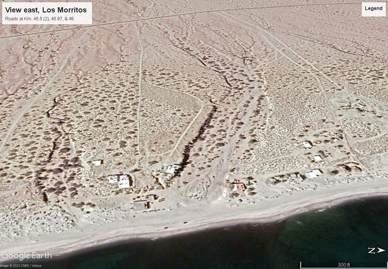
Continuing south, there is a dirt road with only a real estate sign on a barrel, 130 meters north of the Km. 46 marker (call it Km. 45.87). Then, the
well-signed road for Campo San José, which is right at the Km. 46 marker.
When I look down on Google Earth, the homes on the beach at Los Morritos and the Km. 45.87 road are far apart, separated by a big arroyo.
On this image looking inland from the beach to the highway, see the two roads next to each other on the right (Km. 45.5) which are the Mar Y Sol and
Los Morritos roads. Then the road I think you are mentioning (Km. 45.87). On the left is the San José road (Km. 46). The big arroyo would seem to
divide the the two home areas?
|
|
|
PaulW
Ultra Nomad
Posts: 3113
Registered: 5-21-2013
Member Is Offline
|
|
For sure Google has a bunch of new images
Here is a random list of places frequently discussed
La Salida 6-6-22
El Cajon 7-11-22
Matomi 7-11-22
Santa Clara 6-19-20
la Ventana 6-6-22
Pole line, Pinta Pass 9-5-19
Gold mine 9-5-19
el Mochoacan 6-6-22
San Felipe 12-25-20
Huatamote 7-11-22
|
|
|
AKgringo
Elite Nomad
Posts: 6340
Registered: 9-20-2014
Location: Anchorage, AK (no mas!)
Member Is Offline
Mood: Retireded
|
|
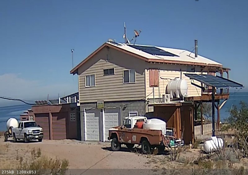
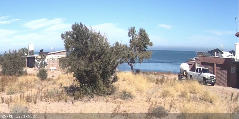
Los Morritos
Now I know where I was! I explored those roads not too long ago....no maps or GPS, just a drive about wondering what was down there.
The building on the beach (left of center) looked like a commercial warehouse or shop building, but I don't know what the nature of the business would
be. It seemed to be a bit too exposed to the surf for a fish camp, but there were a couple of boats around the building.
If you are not living on the edge, you are taking up too much space!
"Could do better if he tried!" Report card comments from most of my grade school teachers. Sadly, still true!
|
|
|
mtgoat666
Platinum Nomad
Posts: 21013
Registered: 9-16-2006
Location: San Diego
Member Is Offline
Mood: Hot n spicy
|
|
| Quote: Originally posted by David K | Updating the San Felipe South Campos Kilometer List using Google Earth Street View of May 2022.
THE SOUTH CAMPOS KILOMETER LIST (let's keep it updated with name changes or additions, etc.)
LIST Under Construction 1-7-23
Updating using Google Earth Street View of May 2022 (and your input):
Km. 0 Airport Road (6.1 miles from San Felipe traffic circle)
Km. 1 La Hacienda
Km. 4+ Tortugas Bay Resort
Km. 4.5 Aquamarina Condotel & Villas Km. 4.5+ S.F. Diamante Residencial |
Dk:
The map world is now gps-digital. I suggest you also provide waypoints. Not sure if anyone relies on KM posts much these days.
Also, Google maps has a way you can contribute to the collective map knowledge. Free. You might like it, you get brownie points for contributing to
the hive. Look up Google guides.
You can also contribute to openstreetmap and other maps that follow a we-are-one / commie ideal of open source knowledge.
Woke!
Hands off!
“Por el bien de todos, primero los pobres.”
“...ask not what your country can do for you – ask what you can do for your country.” “My fellow citizens of the world: ask not what America
will do for you, but what together we can do for the freedom of man.”
Pronoun: the royal we
|
|
|
chippy
Super Nomad
Posts: 1804
Registered: 2-2-2010
Member Is Offline
|
|
| Quote: Originally posted by AKgringo | Now I know where I was! I explored those roads not too long ago....no maps or GPS, just a drive about wondering what was down there.
The building on the beach (left of center) looked like a commercial warehouse or shop building, but I don't know what the nature of the business would
be. It seemed to be a bit too exposed to the surf for a fish camp, but there were a couple of boats around the building. |
Totoaba bladder processing plant perhaps
|
|
|
David K
Honored Nomad
Posts: 65537
Registered: 8-30-2002
Location: San Diego County
Member Is Offline
Mood: Have Baja Fever
|
|
Not everyone pre-loads their gps, if they even have one. The kilometer posts are right there to help anyone find a road off the highway.
Some markers are missing, most are there.
A few south of km 48 are gone as well as km 6 (I think) and 26. I had a list of them, but inadvertently lost it.
This is fun for me, no worries.
Check out the latest on my website.
More changes coming in the future.
|
|
|
RFClark
Super Nomad
Posts: 2470
Registered: 8-27-2015
Member Is Offline
Mood: Delighted with 2024 and looking forward to 2025
|
|
Los Morritos 1 & 2
There’s a 2nd Los Morritos entrance as shown.

[Edited on 1-10-2023 by RFClark]
|
|
|
David K
Honored Nomad
Posts: 65537
Registered: 8-30-2002
Location: San Diego County
Member Is Offline
Mood: Have Baja Fever
|
|
Thanks, so Los Morritos is on both sides of the arroyo? Interesting!
|
|
|
David K
Honored Nomad
Posts: 65537
Registered: 8-30-2002
Location: San Diego County
Member Is Offline
Mood: Have Baja Fever
|
|
List ammended to show two roads for Los Morritos. Many other listings still have ? marks. If anyone know for sure an answer please let me know. Thank
you!
|
|
|


