| Pages:
1
2 |
Pacifico
Super Nomad

Posts: 1299
Registered: 5-26-2008
Member Is Offline
|
|
Kayak trip from Bahia de los Angeles to Santa Rosalia
U2U sent....
"Plan your life as if you are going to live forever. Live your life as if you are going to die tomorrow." - Carlos Fiesta
|
|
|
woody with a view
PITA Nomad
Posts: 15940
Registered: 11-8-2004
Location: Looking at the Coronado Islands
Member Is Offline
Mood: Everchangin'
|
|
he means look for the "U2U" on the top right of each page and click it.
|
|
|
BajaRat
Super Nomad
Posts: 1304
Registered: 3-2-2010
Location: SW Four Corners / Bahia Asuncion BCS
Member Is Offline
Mood: Ready for some salt water with my Tecate
|
|
Time of year........ wind intensity and direction considerations
Have fun, post pics please and welcome to Baja Nomads 
|
|
|
TMW
Select Nomad
Posts: 10659
Registered: 9-1-2003
Location: Bakersfield, CA
Member Is Offline
|
|
There are lots of people in El Barril, I'm sure it would not be hard to find someone willing to keep your vehicle for a small fee.
|
|
|
Pescador
Ultra Nomad
Posts: 3587
Registered: 10-17-2002
Location: Baja California Sur
Member Is Offline
|
|
I have done that trip and would not suggest Jan or Feb unless that is the only time you have available. We get serious north winds during that time
of the year and I have seen Kayak groups get grounded and unable to put to sea for days on end. Fall or Spring is a much better time. From San
Fransisquito to about Punta Prieta you have long sections with not much for protected landing area. Again, I do not know your level of competence but
I was a very accomplished whitewater boater with lots of Class V water and had a very effective roll so surfing ocean waves was a non issue. I also
used a closed deck boat with knee braces built in.
Weather reports are not very good for that area with VHF. Marine band has good reports when the cruising season is going strong, but you usually
will not find a lot of cruisers in Jan and Feb. Also, you might want to consider a Spot tracking device which will give someone on a computer a
continual update as to location. You can also send out an emergency signal if you get into trouble.
|
|
|
StuckSucks
Super Nomad
Posts: 2376
Registered: 10-17-2013
Location: Pacific Plate
Member Is Offline
|
|
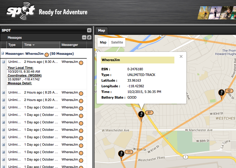
Quote: Originally posted by Pescador  | | Also, you might want to consider a Spot tracking device which will give someone on a computer a continual update as to location. You can also send out
an emergency signal if you get into trouble. |
REALLY good idea. People back home can see where you are and that you're moving. You can send "I'm OK" emails or texts, or summon The Man to come get
you if you're in trouble. Since this works with satellites, it works anywhere in the world that you have a clear view of the sky.
Here's an example of what SPOT displays:
|
|
|
BigBearRider
Super Nomad
Posts: 1299
Registered: 4-30-2015
Location: Big Bear, Punta Chivato, and Cabo
Member Is Offline
Mood: 
|
|
"Since this works with satellites, it works anywhere in the world that you have a clear view of the sky."
That's what I thought too. It worked great on Kilimanjaro a few years ago. My wife got constant updates. It did not work at all in the Serengeti,
although I got the "message delivered" signal from the device. My wife freaked out when she didn't get any messages for a weak and thought I had been
eaten by a lion. Turns out the coverage was not reliable in that area.
Having said that, I have found that the Spot works great in Baja and elsewhere North America.
|
|
|
bajabuddha
Banned
Posts: 4024
Registered: 4-12-2013
Location: Baja New Mexico
Member Is Offline
Mood: Always cranky unless medicated
|
|
I agree on your pick of timing; anywhere on the coast of the SOC in those months you can have a 'norther' blow, and for days... and weeks.. at time.
My clocked record for miserable winds was 13 days non-stop, so looking maybe a little farther south would be good. Another stretch would be Loreto to
Agua Verde also. Mulegé south is a good bet too, you do have a few early take-it-out options (if you have proper vehicles) if you want to bail early.
Buena Suerte, and keep the wet-side down.
edit added: you have enough time to pick up a leeeetle Espagnol. Check with your local high school/adult edu. sites.... a 6 week course in
'conversational' would be helpful, just sayin'.
[Edited on 10-4-2015 by bajabuddha]
I don't have a BUCKET LIST, but I do have a F***- IT LIST a mile long!
86 - 45*
|
|
|
ElCap
Nomad
Posts: 281
Registered: 1-22-2010
Location: Montara CA, or San Ignacio BCS
Member Is Offline
|
|
You could likely leave your vehicle at Beto Lucero's property, which is at the small north-facing cove at Punta San Francisquito. He might charge you
a token fee? He's a great guy, and speaks perfect English. U2U me for his contact info.
I've been wanting to do that trip by kayak myself - have done it a few times by boat. There are definitely some stretches of more than a few kms.
with no landing spots - you could Google Earth it and probably get a good idea of the cliff areas? Also, you'll likely be loaded down with as much
water as you can carry - this will make your boat very heavy but also very stable. If you do end up dumping it I don't think you'll be rolling out of
it, even if you were Pescador
|
|
|
bkbend
Senior Nomad
Posts: 695
Registered: 11-27-2003
Location: central OR or central baja
Member Is Offline
|
|
A portable pump desalinator will reduce the amount of water you will need to carry. Invaluable in the SoC. You can make the next day's water while
you're hunkered down each afternoon.
|
|
|
BajaNomad
|
Thread Moved
10-4-2015 at 03:25 AM |
Marc
Ultra Nomad
Posts: 2802
Registered: 5-15-2010
Location: San Francisco & Palm Springs
Member Is Offline
Mood: Waiting
|
|
Look at the morning sky to the north. Low stratus clouds and mist will tell you to be off the water by mid day.
|
|
|
AndyP
Nomad
Posts: 116
Registered: 12-8-2009
Location: Eugene, OR
Member Is Offline
|
|
I paddled that stretch Spring of 2014. It's very pretty, and definitely felt more isolated and rugged than the Mulege-La Paz run. The water is
colder and there are bigger tides and currents than further south, especially in the midriff area. The waves can get big sometimes, and the wind can
come up fast and goes from zero to dangerous very quickly on occasion. That happens down south also, though. All in all though we had mellow trip,
but it was later in the spring; we did have several periods too windy to paddle, and from what I hear winters can be brutally windy for many days at a
time. We carried enough water that we only resupplied once, at San Francisquito (where there is also cold beer available...:cool. From what I remember there and El Baril are about the only reliable water sources.
I don't think I would attempt the trip in winter without a desalinator just in case of getting pinned down for a week. Make sure you really respect
the wind and be conservative about going out/heading for shore.
I stored my car at a campground in Bahia de Los Angeles (just ask around and someone will definitely help you out for some pesos... I'd expect it
would be easy enough in El Baril or wherever also) and when we finished I took the bus back to the highway junction and hitched from there into town-
no bus does that section.
Mulege or Loreto to La Paz definitely feels like a mellower stretch to me, and is prettier in some ways. As you mention there are more water sources,
but you still have potentially major wind issues to consider in the winter. If you do that stretch the last 50 miles to La Paz are mostly roadside
and north-exposed; I did it once and won't again if I don't have to... this last trip we paddled to San Evaristo and just turned around and paddled
back to Loreto, which we could only do because the wind was cooperating. Outfitters in La Paz will also pick you up if you pre-arrange it.
I strongly recommend Dave Eckardt's book, The Guide to Baja Sea Kayaking. http://paddlepublishing.com/ It will have a lot of info you'll want.
Let me know if you have specific questions.
|
|
|
Pescador
Ultra Nomad
Posts: 3587
Registered: 10-17-2002
Location: Baja California Sur
Member Is Offline
|
|
Water is a serious problem on that route and there are some wells used by ranchers and some small residential areas, but the water is questionable at
best. I used a portable filter that I used backpacking but most of the water I carried. If it is blowing like stink, you will find it blows almost
all day and night. When the Santa Ana winds are howling it can be impossible to paddle. Landings refer more to a stretch that does not have big
swells pounding the land. If they are coming in at an angle, it is dangerous to try to land because you have a strong surge, rip back out an another
angle, and if the boat gets sideways, you are going to be laying over.
Here is another good question? If you have an injury, like a serious cut from landing and need to be evacuated, how do you think that might
happen. The SPOT is a good thing, but in those winds, and as much as I would like to help, I am not coming up the coast for 90 miles in a pounding
sea.
Also, there is a phenomenon that shows about half way from Punta Prieta to San Fransisquito called "Los Elephantes" which is a weird catabolic
wind that blows from the west and can throw up a 10 ft sea in a matter of minutes. Even though this mostly happens at night, I have seen occasions
where it occurred during the day and is unbelievable in it's intensity.
NOLS from Lander, Wyoming does this section but they wait until the spring when we have a major change in the wind patterns. That would be my
recommendation to you as well.
If you have only that time frame, I would suggest you think about the section from Kino Bay to San Carlos on the mainland. The water is about the
same, only on the east side of the Sea of Cortez. There are more settlements in the area and a greater number of landings. The swell is more
manageable there and you can exit in the event of an emergency. Actually the scenery and experience is preferable on that side as well. But whatever
you decide, Buena Suerte or Good Luck.
|
|
|
bajabuddha
Banned
Posts: 4024
Registered: 4-12-2013
Location: Baja New Mexico
Member Is Offline
Mood: Always cranky unless medicated
|
|
El Nortes are a very predictable wind in your time frame, and I think from all the posts you have a good idea what to expect. Also
a former whitewater guide (Cataract Canyon, 70k OOPS! [edit] 78k... we just called it 80k.cu.ft. 1983 etc) the farther you are from help, the higher
the rating of the run due to isolation i.e. the OLD Bio Bio. a Class III can be a Class V if you screw up, even a Class VI, like the 700' container
ship that just disappeard in Joaquin this week. I'd be looking for another route that time of year; save this one for another time, another group
(or same), and safer trip. Tambien, Buena Suerte.
[Edited on 10-6-2015 by bajabuddha]
I don't have a BUCKET LIST, but I do have a F***- IT LIST a mile long!
86 - 45*
|
|
|
woody with a view
PITA Nomad
Posts: 15940
Registered: 11-8-2004
Location: Looking at the Coronado Islands
Member Is Offline
Mood: Everchangin'
|
|
learn to predict (wherever you get your weather info) when a Santa Ana sets up over the Southwest. Think high pressure which builds right after a low
pressure front moves thru. after a low blows across the SW a wind is going to blow from the north for a couple of days. if you time it right, you're
golden.
someone tell him about the west winds that come up and will blow him to the mainland....
[Edited on 10-6-2015 by woody with a view]
|
|
|
bajabuddha
Banned
Posts: 4024
Registered: 4-12-2013
Location: Baja New Mexico
Member Is Offline
Mood: Always cranky unless medicated
|
|
OOH! OOH! Everyone complained of the northers on the Bahia, especially the Cottage Cheese Campers (El Requeson folks) until we got a west wind that
flipped two of their inflatables and wreaked total havoc on their beach.. La Perla just got a little sand.... Enero y Febrero muy malo por viento.
However, with all due respect, no such thing as 'bad weather'..... just bad clothing. At least, when you're young (er). 
I don't have a BUCKET LIST, but I do have a F***- IT LIST a mile long!
86 - 45*
|
|
|
hombre66
Nomad
Posts: 281
Registered: 10-29-2014
Member Is Offline
|
|
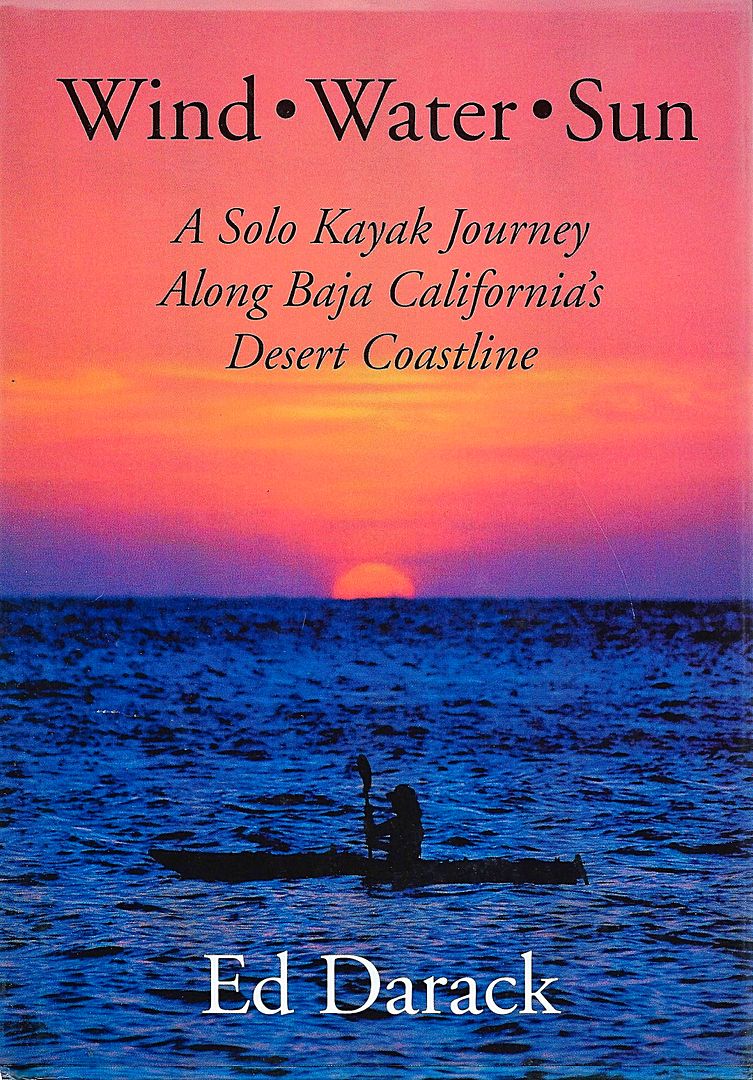
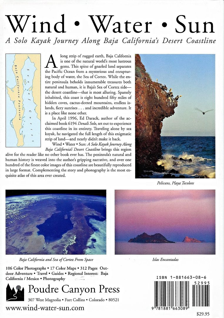
Might want to read "Wind,Water,Sun" by Ed Darack. Long, hairy kayak trip started north of San Felipe.
|
|
|
windgrrl
Super Nomad
Posts: 1336
Registered: 9-2-2006
Member Is Offline
|
|
When highs start dropping over the 4 corners (Nov. thru Feb.) http://www.navajonationparks.org/htm/fourcorners.htm,
wind can be expected.
Local conditions (terrain, gradients, thermals, etc.) are important. The local fisherman know the forecast most days.
When the way comes to an end, then change. Having changed, you pass through.
~ I-Ching
|
|
|
tyguypb
Junior Nomad
Posts: 65
Registered: 11-14-2013
Member Is Offline
|
|
if you decide to postpone this trip till the spring or fall. and you are looking for another able bodied kayaker, let me know. I am an experienced
sea kayak guide and would love to paddle this route. but i will be gone working in Chile all winter 
|
|
|
David K
Honored Nomad
Posts: 65587
Registered: 8-30-2002
Location: San Diego County
Member Is Offline
Mood: Have Baja Fever
|
|
|
|
|
| Pages:
1
2 |