| Pages:
1
..
3
4
5 |
David K
Honored Nomad

Posts: 65565
Registered: 8-30-2002
Location: San Diego County
Member Is Offline
Mood: Have Baja Fever
|
|
For that matter goat, salt flats everywhere in Baja... (flats, not marshes) that get a coating of sea water a few times a year but not daily (to
create the salt)... why are they not all underwater daily???
You are quick to believe a government employee (who has a motive to remain in his position), but not your own eyes at all these salt flats?
They should all have become marshes (daily tidal flooding), or lagoons (annual or multi-month flooding) if the sea levels have risen so dangerously
much.
|
|
|
danaeb
Senior Nomad
Posts: 991
Registered: 11-13-2006
Location: San Diego; El Centenario
Member Is Offline
Mood: groovy
|
|
My eyes tell me that the earth is flat. It must be so.
Experience enables you to recognize a mistake every time you repeat it.
|
|
|
David K
Honored Nomad
Posts: 65565
Registered: 8-30-2002
Location: San Diego County
Member Is Offline
Mood: Have Baja Fever
|
|
You need to go on Google Earth then! 
|
|
|
rts551
Elite Nomad
Posts: 6700
Registered: 9-5-2003
Member Is Offline
|
|
Ohhh heavens no. The google earth people are scientists and google earth is supported by government satellites. Its probably not real since you can
not touch or feel it. Government just feeding us made up images.
|
|
|
mtgoat666
Platinum Nomad
Posts: 21099
Registered: 9-16-2006
Location: San Diego
Member Is Offline
Mood: Hot n spicy
|
|
Quote: Originally posted by rts551  |
Ohhh heavens no. The google earth people are scientists and google earth is supported by government satellites. Its probably not real since you can
not touch or feel it. Government just feeding us made up images.
|
the initial internet (arpanet) was developed by government-funded scientists. al gore was one of the politicians that promoted legislation to expand
arpanet. if it weren't for politicians like nerdy al gore and government funded scientists, dk would have no google earth or baja nomad 
|
|
|
chuckie
Elite Nomad
Posts: 6082
Registered: 2-20-2012
Location: Kansas Prairies
Member Is Offline
Mood: Weary
|
|
+10
|
|
|
rts551
Elite Nomad
Posts: 6700
Registered: 9-5-2003
Member Is Offline
|
|
| Quote: Originally posted by mtgoat666 | | Quote: Originally posted by rts551 |
Ohhh heavens no. The google earth people are scientists and google earth is supported by government satellites. Its probably not real since you can
not touch or feel it. Government just feeding us made up images.
|
the initial internet (arpanet) was developed by government-funded scientists. al gore was one of the politicians that promoted legislation to expand
arpanet. if it weren't for politicians like nerdy al gore and government funded scientists, dk would have no google earth or baja nomad |
Nature would have taken care of it...somehow.
|
|
|
David K
Honored Nomad
Posts: 65565
Registered: 8-30-2002
Location: San Diego County
Member Is Offline
Mood: Have Baja Fever
|
|
Ralph and goat, better get a room!
|
|
|
rts551
Elite Nomad
Posts: 6700
Registered: 9-5-2003
Member Is Offline
|
|
Don't go there DK. unless you can take the heat.
|
|
|
PaulW
Ultra Nomad
Posts: 3113
Registered: 5-21-2013
Member Is Offline
|
|
Marinazul again
Marinazul Golf & Resort
Developed by Inveranate Crecentia,SA DE CV
Got curious after doing the Percebu poker run to see where we were driving compared to the new marina. The answer is we were somewhat north of the
development parcel and closer to Percebu. I also noted that Davids coords for shell island pretty much land on the entrance to the marina at N30 46.3
Location on IGENI H11B57 With an image date of June 1993
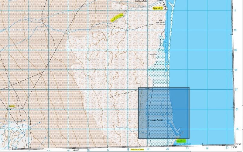
Next topo map south H11B67
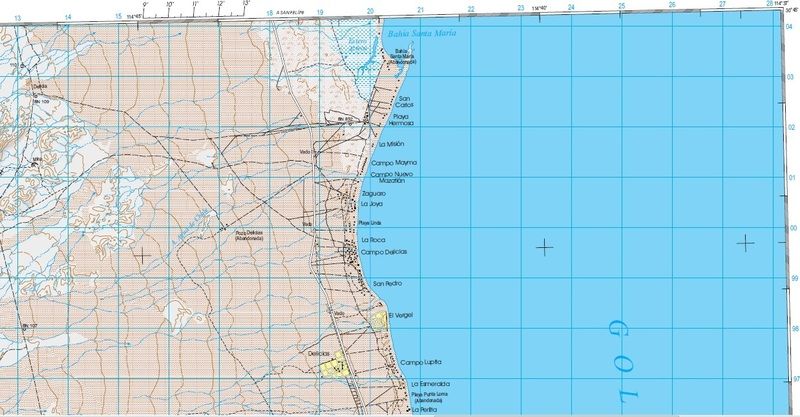
Next I found these images on the web locating the marina
AND
|
|
|
David K
Honored Nomad
Posts: 65565
Registered: 8-30-2002
Location: San Diego County
Member Is Offline
Mood: Have Baja Fever
|
|
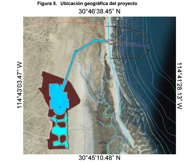
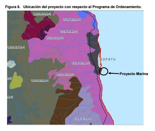
That bottom map is off... they have the circle from the south edge of Bahia Santa Maria to Nuevo Mazatlan. The project is north and west of Bahia
Santa Maria bay.
Building a marina on a salt flat that the next chubasco washes out will be waste of money, I believe.
Yes, the marina breakwater is about where the fish camp and road onto the island is located.
That breakwater will stop the natural movement of sand down the coast. It will clog the entrance (as in what happened at the La Salina marina near La
Mision and at the Escalera Nautica marina at Santa Rosalillita.
I see no good coming to this project... wrong location... and after destroying the natural ecosystem between Laguna Percebu and Bahia Santa Maria, it
will be abandoned. It will be even worse than what they did to Puerto Escondido, south of Loreto.
I am so fortunate to have enjoyed Shell Island from my first time on it in the 1960's when we drove it in our Wagoneer to Percebu, camping on it from
1978 to last July... maybe my last time, but I hope not!?
|
|
|
CortezBlue
Super Nomad
Posts: 2213
Registered: 11-14-2006
Location: Fenix/San Phelipe
Member Is Offline
|
|
Shell Beach
Two things are infinite: the universe and human stupidity; and I'm not sure about the universe.
- Albert Einstein
Follow Cortez Blue
www.cortezblue.com
We put the FUNK in disFUNKtion |
|
|
David K
Honored Nomad
Posts: 65565
Registered: 8-30-2002
Location: San Diego County
Member Is Offline
Mood: Have Baja Fever
|
|
Yes, that's where Russ sends us those great sunrise photos from! It is next to Punta Chivato... but why have two places on the peninsula with the same
name when there is another option?
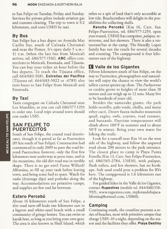
Anyway, the Moon Baja guidebooks are onboard, see under Estero Percebú:
|
|
|
Udo
Elite Nomad
Posts: 6364
Registered: 4-26-2008
Location: Black Hills, SD/Ensenada/San Felipe
Member Is Offline
Mood: TEQUILA!
|
|
Thanks for the clever picture, DK!
Udo
Youth is wasted on the young!
|
|
|
| Pages:
1
..
3
4
5 |