| Pages:
1
2 |
WideAngleWandering
Nomad

Posts: 416
Registered: 3-13-2012
Location: US-Based but traveling
Member Is Offline
|
|
March 2016 Baja Roadtrip Planning Thread
Howdy nomads,
I'll be setting off next Sat for our annual Baja trip. Have to be back in Sacramento by the 21st, so that gives us just a hair over 3 weeks. I'm
still driving my oldish landcruiser. I'll be joined for 2 of those weeks by a friend in a stock Cherokee, and one of them by another friend in a
lifted landcruiser. We like to wheel but the Cherokee will probably keep us on the saner roads. Goals for this trip are whale watching with Shari in
Ojo de Liebre, drive down to Concepcion and then to El Sargento, and a few days in San Felipe at the end to get some work done on the truck.
Enough preamble, on to some questions.
I usually overnight at Mama Espinoza's when driving from Ensenada to Ojo de Liebre. Thinking about camping this time. Recommendations? I get the
impression boondocking around cataviña is a bad idea?
I'd like to camp around Bahia Concepcion, within a days drive of Bahia Asuncion. Recommendations? I carry my own shade but not averse to renting
a palapa.
Has anyone ever seen or heard about bioluminescent plankton around el sargento? Some folks I met last year told me about it but I haven't found
any any trip reports.
Happy travels,
Guy
Traveling the Americas via my old land cruiser
|
|
|
Chupacabra
Nomad
Posts: 476
Registered: 7-11-2013
Location: La Jolla, CA
Member Is Offline
|
|
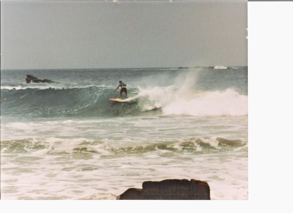
In regards to the first question, I often camp at Punta Baja. It's just west of El Rosario. The best camping is a little south of the point where
it's nice and quiet. There's usually something to surf and pretty good perch fishing too.
And it's free!
************************************
WTF
|
|
|
Chupacabra
Nomad
Posts: 476
Registered: 7-11-2013
Location: La Jolla, CA
Member Is Offline
|
|
Camping at Punta Baja:


[Edited on 2-20-2016 by Chupacabra]
************************************
WTF
|
|
|
WideAngleWandering
Nomad
Posts: 416
Registered: 3-13-2012
Location: US-Based but traveling
Member Is Offline
|
|
Nice - I think that's a good spot. How many hours from Ensenada? By the map it looks reachable before sundown.
Traveling the Americas via my old land cruiser
|
|
|
BajaRat
Super Nomad
Posts: 1304
Registered: 3-2-2010
Location: SW Four Corners / Bahia Asuncion BCS
Member Is Offline
Mood: Ready for some salt water with my Tecate
|
|
Just make the right turn at the Mama Espinoza curve (hwy 1 )and follow the well traveled road to the beach.
Lionel
|
|
|
Chupacabra
Nomad
Posts: 476
Registered: 7-11-2013
Location: La Jolla, CA
Member Is Offline
|
|
It's near Mama Espinozas so only three hours or so. In fact, that's where you turn right to exit the highway at the hairpin turn. Go west about a
block then make a left and you will shortly be on wide dirt road that parallels the arroyo.
About a mile or so down you can cross over to the south side of the arroyo to enter the little town of El Rosario de Abajo. There are some old adobe
ruins there if you like that kind of thing. Head west and you will see a sign that says Punta Baja, turn left there and it's about 20 minutes away on
a well-graded dirt road.
Make sure to cross over to the south side of the arroyo or you will end up at the rivermouth, which is a pretty good place to camp too but deep sand.
************************************
WTF
|
|
|
woody with a view
PITA Nomad
Posts: 15940
Registered: 11-8-2004
Location: Looking at the Coronado Islands
Member Is Offline
Mood: Everchangin'
|
|
ER is 5 hours from the border including a taco stop!
|
|
|
mtgoat666
Platinum Nomad
Posts: 21152
Registered: 9-16-2006
Location: San Diego
Member Is Offline
Mood: Hot n spicy
|
|
Quote: Originally posted by WideAngleWandering  | Howdy nomads,
I'll be setting off next Sat for our annual Baja trip. Have to be back in Sacramento by the 21st, so that gives us just a hair over 3 weeks. I'm
still driving my oldish landcruiser. I'll be joined for 2 of those weeks by a friend in a stock Cherokee, and one of them by another friend in a
lifted landcruiser. We like to wheel but the Cherokee will probably keep us on the saner roads. Goals for this trip are whale watching with Shari in
Ojo de Liebre, drive down to Concepcion and then to El Sargento, and a few days in San Felipe at the end to get some work done on the truck.
Enough preamble, on to some questions.
I usually overnight at Mama Espinoza's when driving from Ensenada to Ojo de Liebre. Thinking about camping this time. Recommendations? I get the
impression boondocking around cataviña is a bad idea?
I'd like to camp around Bahia Concepcion, within a days drive of Bahia Asuncion. Recommendations? I carry my own shade but not averse to renting
a palapa.
Has anyone ever seen or heard about bioluminescent plankton around el sargento? Some folks I met last year told me about it but I haven't found
any any trip reports.
Happy travels,
Guy |
Catavina is a great place for boondocking. Lots of unpaved roads leading to any number of great camp sites amongst the rocks.
|
|
|
WideAngleWandering
Nomad
Posts: 416
Registered: 3-13-2012
Location: US-Based but traveling
Member Is Offline
|
|
I must start late, drive slow, stop for too many tacos,and spend too much time ogfling the scenery as I thought it took a bit longer than that. Good
deal.
As for cataviña, I often stop to explore the cacti and boulders off hwy1 but somehow had it I my head that banditos were becoming a thing. Out of
sight should be ok though?
Traveling the Americas via my old land cruiser
|
|
|
bajabuddha
Banned
Posts: 4024
Registered: 4-12-2013
Location: Baja New Mexico
Member Is Offline
Mood: Always cranky unless medicated
|
|
#3. This time of year the 'bioluminescence' you'll see will be orangish scum that's actually half-beak or needlefish roe that winds blow into shore;
best viewed on new moon or low moonlight, don't be afraid to wade or even better, boat through it. When camped in Bahia Concepcion i'd build a nice
fire in my fire pit for a reference, and take out my inflatable and do brodies through the stuff.... magical in the bow wake and motor wash.
I don't have a BUCKET LIST, but I do have a F***- IT LIST a mile long!
86 - 45*
|
|
|
AKgringo
Elite Nomad
Posts: 6368
Registered: 9-20-2014
Location: Anchorage, AK (no mas!)
Member Is Offline
Mood: Retireded
|
|
Bioluminesence
I did not see a display at El Sargento in the brief time I spent there, but I did in Los Barrilles about the same time frame (mid March) but it was
not very active.
I have seen pretty good displays on the mainland around Ziuateno, and Manzanillo, and even up in Prince William Sound up in Alaska, but by far the
most impressive light show I ever saw in the water, was at the south end of Santispac beach south of Mulege!
It was late February, or the first week of March, and it was spectacular! Fish swimming along near the beach were being outlined in blue. A skiff
running parallel to the beach had a neon bow wave and prop wash. Every wave breaking, or hand full of sand thrown in the water would light up.
From my experience, your timing looks right, I hope you get lucky!
Edit; I just read Buddah's post. Maybe things in Conception have changed. The perfect display we saw was in 1986, but my time frame is accurate,
and it was not scummy.
[Edited on 2-20-2016 by AKgringo]
If you are not living on the edge, you are taking up too much space!
"Could do better if he tried!" Report card comments from most of my grade school teachers. Sadly, still true!
|
|
|
WideAngleWandering
Nomad
Posts: 416
Registered: 3-13-2012
Location: US-Based but traveling
Member Is Offline
|
|
There's a lagoon on the mainland Pacific Coast, Laguna Chacahua, with brilliant bioluminescence. Also home to an Afro Mexican community of slave
descendant. It's a cool place with lots of reggae.
Traveling the Americas via my old land cruiser
|
|
|
David K
Honored Nomad
Posts: 65587
Registered: 8-30-2002
Location: San Diego County
Member Is Offline
Mood: Have Baja Fever
|
|
About half the distance from El Rosario is the beach they call La Bocana (where the El Rosario river meets the ocean). There are two routes to it...
Photos in these pages:
http://vivabaja.com/206/page4.html
http://vivabaja.com/505/
http://vivabaja.com/505/page2.html (includes mission ruins passed along the low road)
EL ROSARIO to LA BOCANA (High Road)
0.0 mi. Turn Right off highway at the sharp bend in town.
Continue west passing by the road left to El Rosario de Abajo and Punta Baja.
0.8 mi. Fork, go right.
1.2 mi. Fork, go right... road heads uphill.
1.5 mi. Pass palapas and banana trees, climb hill.
2.2 mi. View point, see La Bocana beach.
2.6 mi. Go straight, left is a poor road.
2.9 mi. Fork, go left... Ahead is a locked gate.
3.0 mi. Fork, go left... Right is the entrance gate to Diamante Del Mar.
3.6 mi. Fork, go ahead/ left. Right is a poor road.
3.9 mi. Fork, go right, to the beach.
5.3 mi. La Bocana Beach
EL ROSARIO to LA BOCANA (Valley Road, 4WD)
0.0 mi. Turn Right (west) off Highway 1 at the sharp curve in El Rosario.
In about 100 yards, turn left on road for El Rosario de Abajo and Punta Baja.
Cross over El Rosario river culvert pipe and soon turn right in the river valley, some water crossings before reaching the south bank of the river and
entering the town of El Rosario de Abajo.
1.5 mi. El Rosario Museum, on left. Photos taken inside at http://vivabaja.com/505/page6.html
1.6 mi. Rosario de Abajo mission ruins, on right.
2.5 mi. Road left for Punta San Antonio and the coast south of Punta Baja.
2.9 mi. Road left for Punta Baja, continue ahead (west).
3.1 mi. Turn right for La Bocana, deep water crossing soon.
4.2 mi. Come to a fence, turn left to opening then continue west, Deep sand ahead.
5.1 mi. La Bocana Beach
|
|
|
bajabuddha
Banned
Posts: 4024
Registered: 4-12-2013
Location: Baja New Mexico
Member Is Offline
Mood: Always cranky unless medicated
|
|
| Quote: Originally posted by AKgringo |
...... but by far the most impressive light show I ever saw in the water, was at the south end of Santispac beach south of Mulege!
Edit; I just read Buddah's post. Maybe things in Conception have changed. The perfect display we saw was in 1986, but my time frame is accurate,
and it was not scummy. |
Yup, time frame is good, place is good. I wintered for months at a time at La Perla, about 12 miles south of Santispac for 15 years. The fish roe
would start late winter, early spring, and be sporadic. They would come in clusters (pun intended) and be floating 'blobs' of orange out not far from
shore, and depending on wind action the goo would drift and lengthen. It's kind-of 'scummy' in the daylight; just imagine what it's really made of.
Definitely orange, and very visible during the day. If the breeze blew at night (moonless) and there was wave action even the small breakers
crumping on the shoreline would light up. It needs movement to set off the chemical reaction that triggers the light. My 14' inflatable made
incredible trips for dozens and dozens of fellow campers that were nuts enough to go out with me in the dark..... many fond memories, many thrilled
people, most of all, ME. T'was my second-most favorite Baja treat, next to playing with the dolphins in Spanky the boat.
Thank you, little fishies. 
[Edited on 2-21-2016 by bajabuddha]
I don't have a BUCKET LIST, but I do have a F***- IT LIST a mile long!
86 - 45*
|
|
|
WideAngleWandering
Nomad
Posts: 416
Registered: 3-13-2012
Location: US-Based but traveling
Member Is Offline
|
|
Excellent stuff folks.
Any recommendations for Bahia Concepcion camping? I think I have the coordinates in my GPS to a place where I can boondock (spent an afternoon there
in 2012) but it was pretty far south. In the event we are arriving late in the day we might stop further north. Any recent experience? I have an
awning on my truck but not opposed to renting a palapa.
I imagine the water will be pretty chilly this time of year, swimming?
Traveling the Americas via my old land cruiser
|
|
|
woody with a view
PITA Nomad
Posts: 15940
Registered: 11-8-2004
Location: Looking at the Coronado Islands
Member Is Offline
Mood: Everchangin'
|
|
| Quote: Originally posted by WideAngleWandering | | There's a lagoon on the mainland Pacific Coast, Laguna Chacahua, with brilliant bioluminescence. Also home to an Afro Mexican community of slave
descendant. It's a cool place with lots of reggae. |
we used to surf there in the mid-late 80's. this was before what is has become now. there was only the crocodile farm right at the point and the
lagoon was sealed in by a huge sand berm. i've got video of it somewhere.
edit: 5-20-87
[Edited on 2-21-2016 by woody with a view]
|
|
|
woody with a view
PITA Nomad
Posts: 15940
Registered: 11-8-2004
Location: Looking at the Coronado Islands
Member Is Offline
Mood: Everchangin'
|
|
yep, another wave destroyed in the name of progress!

|
|
|
AKgringo
Elite Nomad
Posts: 6368
Registered: 9-20-2014
Location: Anchorage, AK (no mas!)
Member Is Offline
Mood: Retireded
|
|
Playa Santispac
I recommend stopping at the place I mentioned earlier. Santispac is about ten or twelve miles south of Mulege. It may be closer to the highway than
you would like, but there is a great beach, good food, showers available, and is still very much like it was back in 1986.
Camping at the north end puts you close to the restaurant and bath facilities, the south end is quieter (except for trucks on the highway above) and
there is a small tidal mangrove estuary with a hot spring at the end of it.
The weather pattern in 86 was very similar to this year, and my kids and I had no problem snorkeling without wet suits at the end of February. We had
just driven down from Alaska, so that may have warped our sense of 'warm'.
Good luck, and report back with what you find. By the way, there are a lot of folks from Grass Valley that have been hanging out there for years, you
will probably meet one or two of them if you visit the restaurants around there.
Edit; I am not stuck in 1986, that was just my first stay there. I was last there in late Nov, 2014, and intend to return next trip.
[Edited on 2-21-2016 by AKgringo]
If you are not living on the edge, you are taking up too much space!
"Could do better if he tried!" Report card comments from most of my grade school teachers. Sadly, still true!
|
|
|
bajabuddha
Banned
Posts: 4024
Registered: 4-12-2013
Location: Baja New Mexico
Member Is Offline
Mood: Always cranky unless medicated
|
|
I concur with AK, Santispac is a good beach for swimming; watch for rays in March, they're shallow and breeding. The southern beaches aren't secure
and as safe as they used to be; if you're in a group you should be fine though, safety in (a few) numbers. Isla Requeson is a good camp also; and if
you don't have large trailers (just single rigs) Playa Escondida is wonderful; just past (south of) the Posada complex of houses, road goes up and
over a low pass into a wonderful cove. More secluded. Santispac will give you better access to restaurant etc, but more people for sure.
I don't have a BUCKET LIST, but I do have a F***- IT LIST a mile long!
86 - 45*
|
|
|
WideAngleWandering
Nomad
Posts: 416
Registered: 3-13-2012
Location: US-Based but traveling
Member Is Offline
|
|
Good tips, many thanks. Here's another one for you. We may spend a night in La Paz (gotta love those drunken street hot dogs). I'd need a place to
stay that is dog friendly for my buddy and ideally has secure parking.
I stayed at Hostel Baja Backpackers on Mutualismo the last time I was there but they only have one private room and I'm pretty sure dogs are a no-go.
The time before that we stayed in a place that was close to a gay disco and had a semi-secure parking lot. I can't remember the name but I do remember
it rained hard that night and the retaining wall collapsed on my friends truck. We had to get the fire department to pull it out of the rubble.
Recommendations?
[Edited on 2016-2-22 by WideAngleWandering]
Traveling the Americas via my old land cruiser
|
|
|
| Pages:
1
2 |


