| Pages:
1
2 |
rotortom
Newbie
Posts: 11
Registered: 9-10-2016
Member Is Offline
|
|
Jeeping and rockhounding Bahia Gonzaga/Catavina areas
My wife and I are planning a ten day trip to Northern Baja in a couple of weeks, and would like to do some rockhounding and Jeeping around that area.
We will be at Alfonsinas for 4 nights and the rest is not planned. Anybody here have any ideas? We will be driving a moderately built Wrangler
Rubicon.
Thanks!
|
|
|
ehall
Super Nomad

Posts: 1906
Registered: 3-29-2014
Location: Buckeye, Az
Member Is Offline
Mood: It's 5 o'clock somewhere
|
|
Day trip to see Coco then to Calamajue fish camp. Return to Gonzaga on the old mine trail.
[Edited on 9-11-2016 by ehall]
|
|
|
bajapedro
Nomad
Posts: 153
Registered: 3-2-2016
Member Is Offline
|
|
One better would be to drive through Calamajue canyon. There is geology aplenty in the canyon, with each turn a different color of canyon wall. While
there, you might want to check out the remains of Mission Calamajue. Just south of the canyon, the desert unfolds into a desert forest.
|
|
|
rotortom
Newbie
Posts: 11
Registered: 9-10-2016
Member Is Offline
|
|
ehall, we are planning a visit with Coco. We last visited him in November of 2002, and I understand he has lost another leg since then. I would like
some GPS coordinates for the old mine trail if you have them. I looked on Google Earth and didn't find it.
bajapedro, I plan to take Calamuje up to near where it hits the 1. In 2002 Coco did not advise us to take the Dodge 4x4 pickup with a popup camper on
it up that canyon. I guess I took that as a personal challenge and made it, but not until we aired down the tires and had some anxious moments.
We are going for a week or so in the area. Keep the replies coming!!
|
|
|
mtgoat666
Platinum Nomad
Posts: 21152
Registered: 9-16-2006
Location: San Diego
Member Is Offline
Mood: Hot n spicy
|
|
Quote: Originally posted by rotortom  | My wife and I are planning a ten day trip to Northern Baja in a couple of weeks, and would like to do some rockhounding and Jeeping around that area.
We will be at Alfonsinas for 4 nights and the rest is not planned. Anybody here have any ideas? We will be driving a moderately built Wrangler
Rubicon.
Thanks! |
For rockhounding, I suggest San Pedro martir region,... Lots of granitoids and metamophics,... But you'll need to hike to see the cool stuff,
experience the best rock nirvannas.
|
|
|
ehall
Super Nomad
Posts: 1906
Registered: 3-29-2014
Location: Buckeye, Az
Member Is Offline
Mood: It's 5 o'clock somewhere
|
|
| Quote: Originally posted by rotortom | ehall, we are planning a visit with Coco. We last visited him in November of 2002, and I understand he has lost another leg since then. I would like
some GPS coordinates for the old mine trail if you have them. I looked on Google Earth and didn't find it.
bajapedro, I plan to take Calamuje up to near where it hits the 1. In 2002 Coco did not advise us to take the Dodge 4x4 pickup with a popup camper on
it up that canyon. I guess I took that as a personal challenge and made it, but not until we aired down the tires and had some anxious moments.
We are going for a week or so in the area. Keep the replies coming!! |
Is this rotortom from Tucson? Maybe DK could post a picture off one of his old maps. If not I will do a Google Earth screen shot for you tomorrow.
|
|
|
AKgringo
Elite Nomad
Posts: 6368
Registered: 9-20-2014
Location: Anchorage, AK (no mas!)
Member Is Offline
Mood: Retireded
|
|
I drove the Calamajue canyon headed north from highway 1 a couple of years ago (the Baja 1k used it that year). I was driving a Kia Sportage two
door, with stock suspension and oversize tires and had no problems.
Any well outfitted 4x4 could have done the route at that time, but there have been a couple of storms since then. I saw no one else, and damned few
fresh tracks. Coco thought I was a fool for doing it alone at that time of the year.
If you are not living on the edge, you are taking up too much space!
"Could do better if he tried!" Report card comments from most of my grade school teachers. Sadly, still true!
|
|
|
TMW
Select Nomad
Posts: 10659
Registered: 9-1-2003
Location: Bakersfield, CA
Member Is Offline
|
|
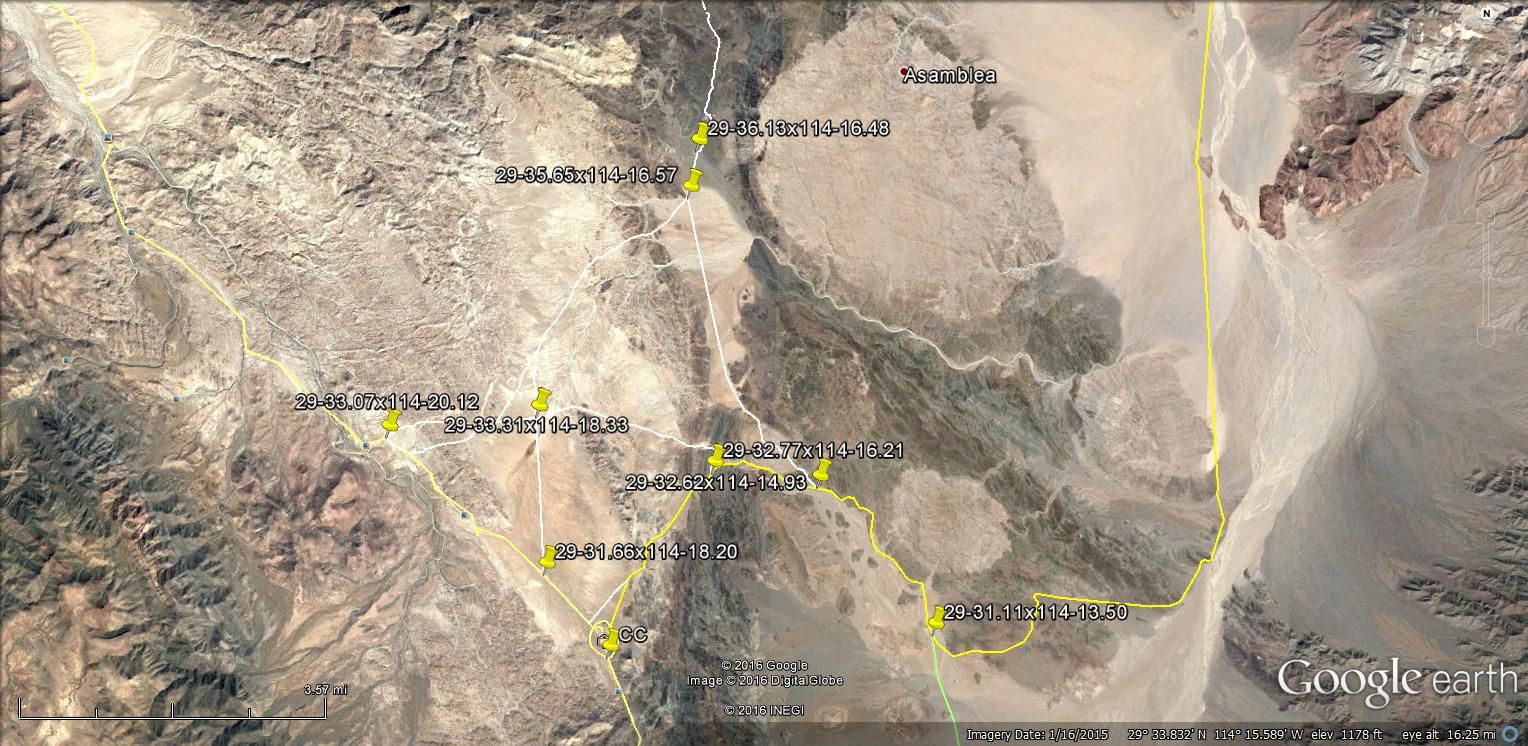
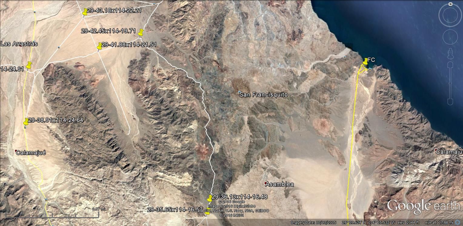
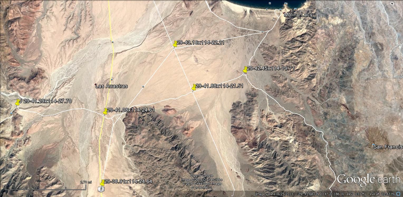
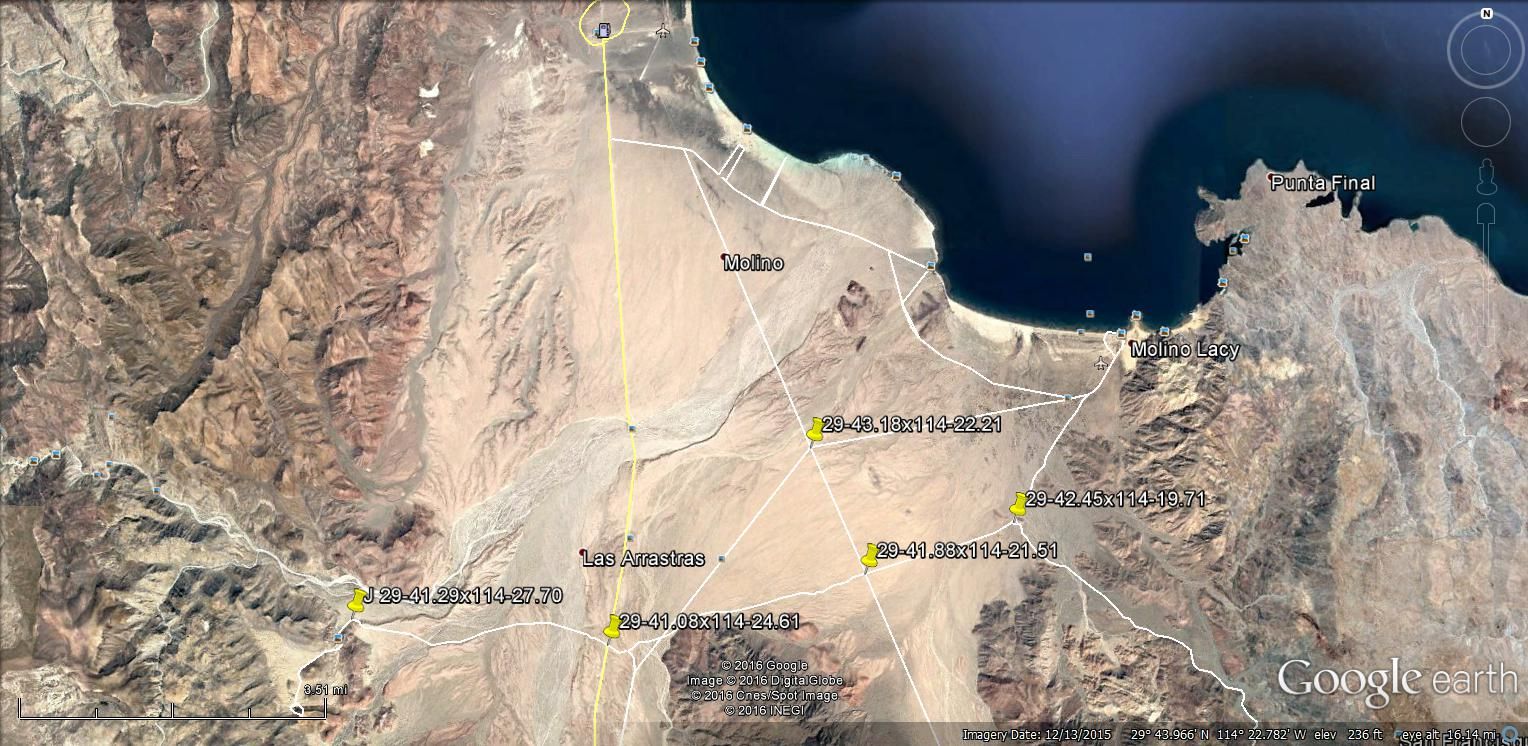
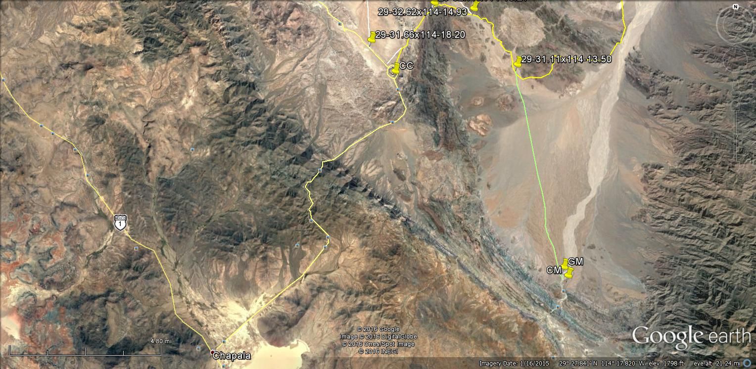
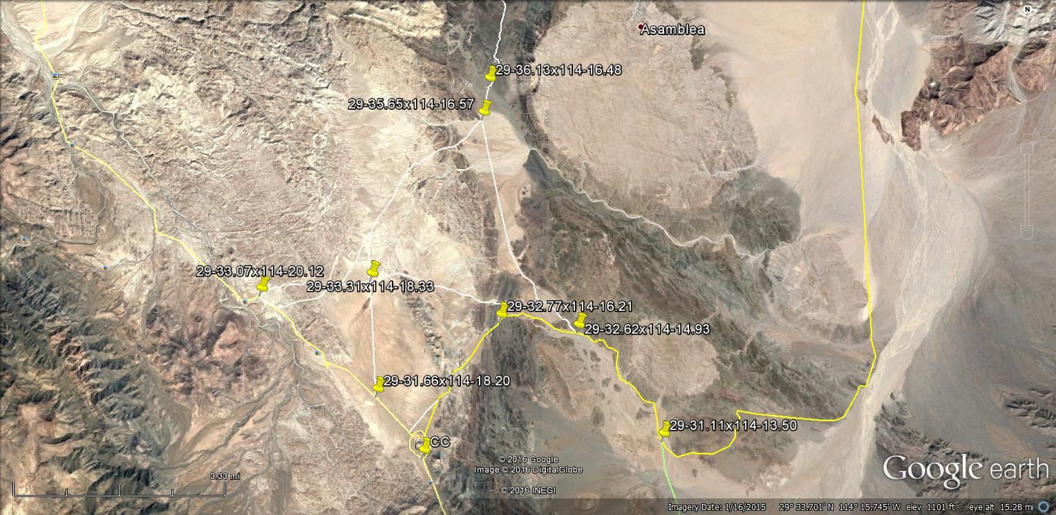
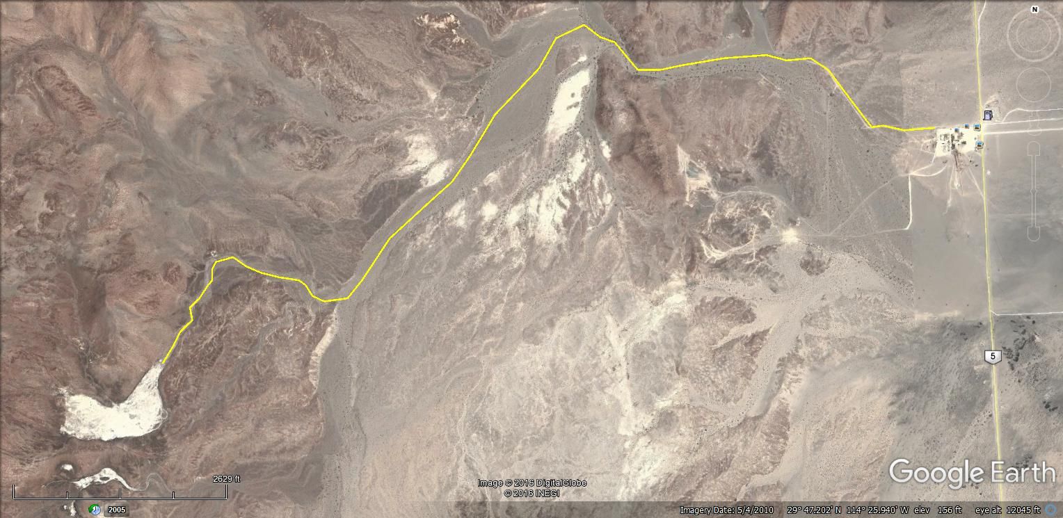
Here are some GE images of trails around Coco's and Gonzaga Bay area. The heavy rains the past couple of years may have damaged the trails so beware.
I did not include the junction for the Turquesa mine since the new Hwy construction may make it impossible to access. The fourth image down there is a
trail west that takes you to an oasis of palm trees and also a junction north to the Padre Mission Trail to Mission Santa Maria.
[Edited on 9-11-2016 by TMW]
|
|
|
rotortom
Newbie
Posts: 11
Registered: 9-10-2016
Member Is Offline
|
|
Yep, this is rotortom from Tucson.
|
|
|
ehall
Super Nomad
Posts: 1906
Registered: 3-29-2014
Location: Buckeye, Az
Member Is Offline
Mood: It's 5 o'clock somewhere
|
|
Lol. Small world. Me and my wife kendra went jeeping with you a couple years ago. We ran Charleau gap and Chivas falls. We were in the red tj
rubicon. Where else are you going besides Gonzaga? A nice drive is south from Rumorosa to Ojos negros. This goes thru the forest. You ever been to
Mikes sky ranch, Coyote ranch or Melling ranch?
|
|
|
David K
Honored Nomad
Posts: 65587
Registered: 8-30-2002
Location: San Diego County
Member Is Offline
Mood: Have Baja Fever
|
|
The one 4x4 between Cataviña and Gonzaga is described here: http://vivabaja.com/msm2010 and drop the 2010 for the previous trip.
Calamajue canyon was great last week. Coco was fine, too.
|
|
|
ehall
Super Nomad
Posts: 1906
Registered: 3-29-2014
Location: Buckeye, Az
Member Is Offline
Mood: It's 5 o'clock somewhere
|
|
I meant the old mine rd from Punta final to cocos. Never been on the road to turquesa mine.
|
|
|
TMW
Select Nomad
Posts: 10659
Registered: 9-1-2003
Location: Bakersfield, CA
Member Is Offline
|
|
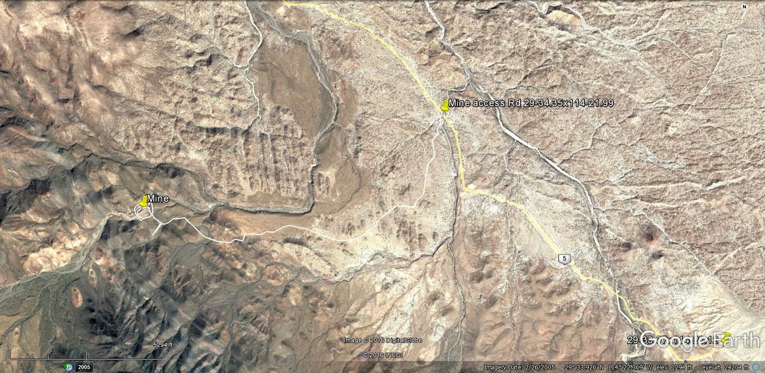
Here is a GE image showing the Turquesa mine road from the old graded road (hwy 5). The image is dated 2005 so who knows what the road building crew
has done to it. Maybe fenced off or will be when the Hwy is done.
|
|
|
TMW
Select Nomad
Posts: 10659
Registered: 9-1-2003
Location: Bakersfield, CA
Member Is Offline
|
|
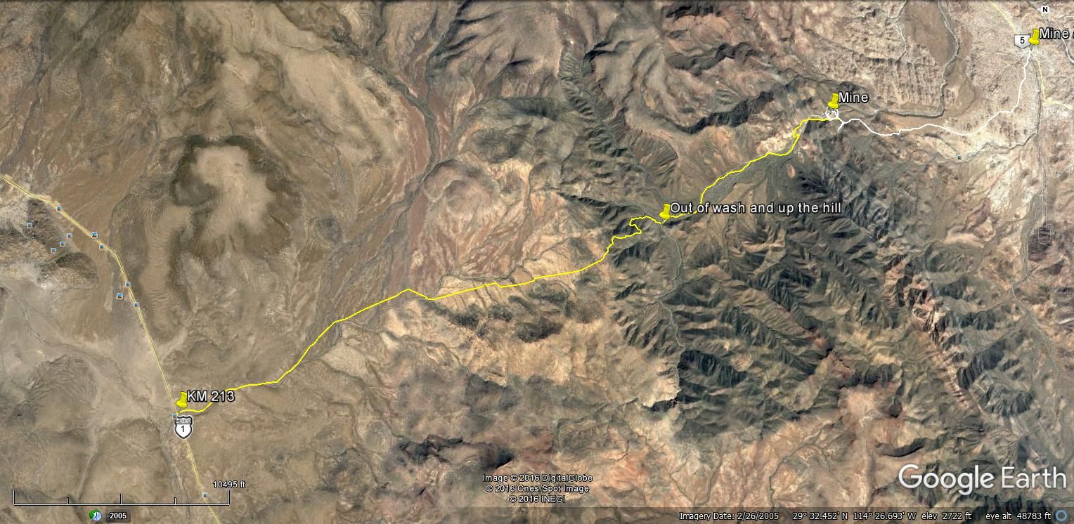
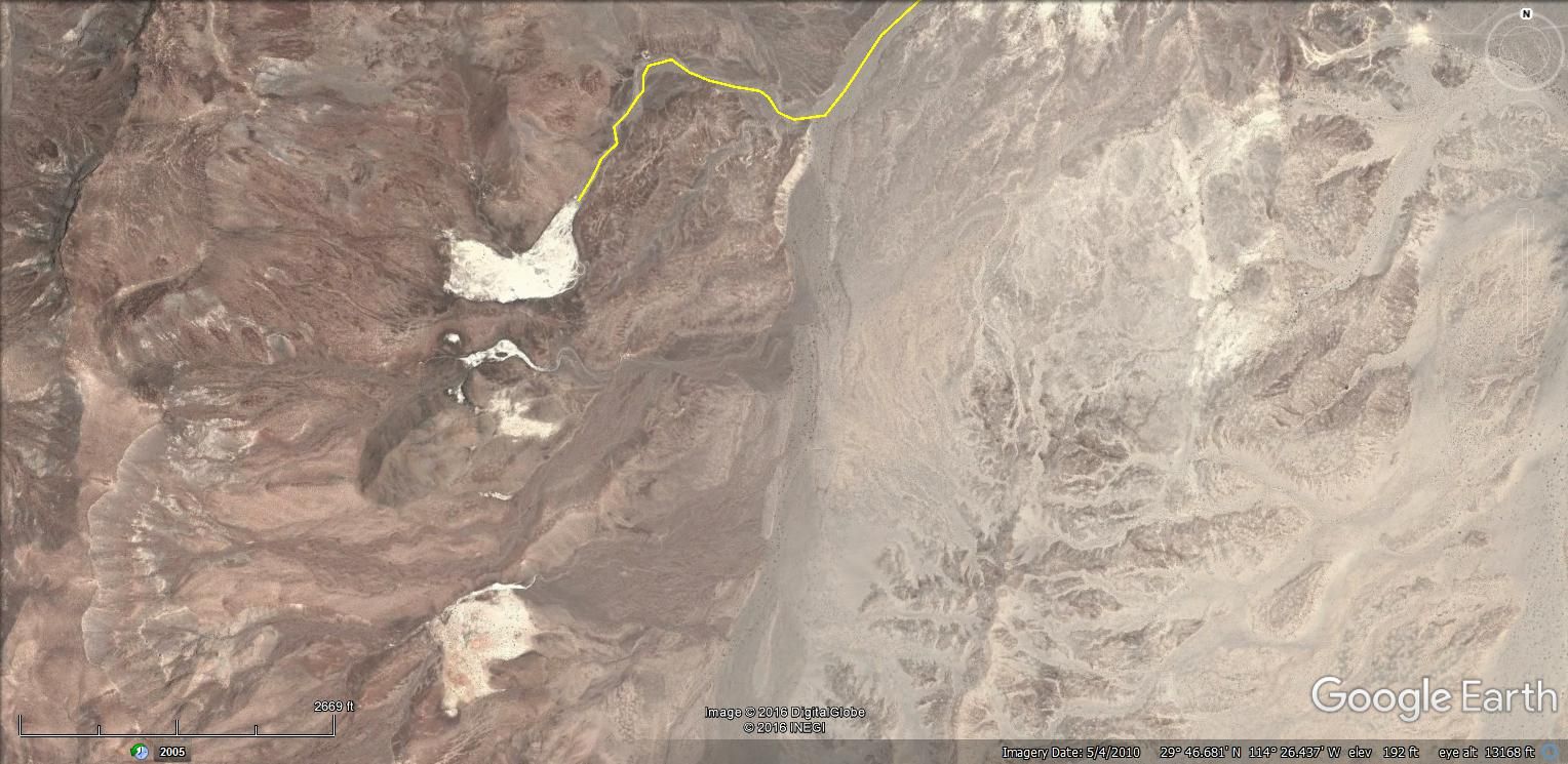
Here is the mine road from the mine to Hwy 1. Two Nomads have done it in 4x4 vehicles in the last 10 years. The squarecircle and 4x4abc. Motorcycles
regularly use it as a crossover road.
|
|
|
rotortom
Newbie
Posts: 11
Registered: 9-10-2016
Member Is Offline
|
|
I guess I will have to check out the Turquesa road and report back here. It is starting to look like I may have to extend at Alfonsinas! Damn!
ehall, I rember you two. The only picture I have of your rig on Charoleau is when we were climbing the granite elevator on the first part of the
trip. You were waiting at the bottom, a long way away so I did not send it to you.
Keep the ideas coming. We would like some info on snorkeling with Whale Sharks. Any tours like that available? I am a bit concerned that too many
folks doing that might interfere with their behavior. Your ideas on that please.
|
|
|
TMW
Select Nomad
Posts: 10659
Registered: 9-1-2003
Location: Bakersfield, CA
Member Is Offline
|
|
Are you aware of the onyx field in the Gonzaga Bay area. Worth a day trip.
|
|
|
ehall
Super Nomad
Posts: 1906
Registered: 3-29-2014
Location: Buckeye, Az
Member Is Offline
Mood: It's 5 o'clock somewhere
|
|
Twice I have seen whale sharks cruising close to the beach while I was at alfonsinas.
|
|
|
ehall
Super Nomad
Posts: 1906
Registered: 3-29-2014
Location: Buckeye, Az
Member Is Offline
Mood: It's 5 o'clock somewhere
|
|
Just saw on talk baja that they are diving with them at Bay of La. About 3 hrs from gonzaga.
|
|
|
rotortom
Newbie
Posts: 11
Registered: 9-10-2016
Member Is Offline
|
|
TMW, Where is the Onyx field? i have always just driven through this area of Baja, just stopping in to see Coco or have a beer at Alfonsinas.
|
|
|
TMW
Select Nomad
Posts: 10659
Registered: 9-1-2003
Location: Bakersfield, CA
Member Is Offline
|
|
It's only a couple of miles west from the store. When I was last there you could drive within about 1/4 mile from it. I have not checked out the white
areas further south to see what they were. Go to Google Earth to get GPS coordinates if needed.
|
|
|
| Pages:
1
2 |


