| Pages:
1
2
3
4
5 |
TMW
Select Nomad

Posts: 10659
Registered: 9-1-2003
Location: Bakersfield, CA
Member Is Offline
|
|
Quote: Originally posted by PaulW  | Around 9mpg for Roy. Not to bad Probably even better with real miles traveled.
Tom, the gps issue is not because of Rich's track. It is a good track and overlays very closely with more recent tracks I have.
The guy that drove the track the week before you was traveling a very old land cruiser. Surprised you did not see his tracks? He did it with two
fivers as backup. Solo drive and never got stuck. |
We mostly followed the Land Cruiser using his tire prints as a reference. There were other 4x4 tracks and 3 or 4 motorcycle tracks. The problem was
over the rocks it was hard at times to see any sign of tracks so we would walk ahead to pick them back up, often when they hit a sanding patch.
I used Garmin BaseCamp to load Rich's GPS track and thought it would just work and show me the GPS track, that is how the E32 program works, but it
didn't work. I'll figure it out.
We're planning another NWT run for April and I should be better prepared with my GPS.
|
|
|
David K
Honored Nomad
Posts: 65565
Registered: 8-30-2002
Location: San Diego County
Member Is Offline
Mood: Have Baja Fever
|
|
Tom, maybe ask John M what he uses as his GPS track of race course is how he helped Ken Cooke and the rest of us find our way through that ejido east
of Guadalupe Canyon entrance at last year's Pole Line Run.
|
|
|
TMW
Select Nomad
Posts: 10659
Registered: 9-1-2003
Location: Bakersfield, CA
Member Is Offline
|
|
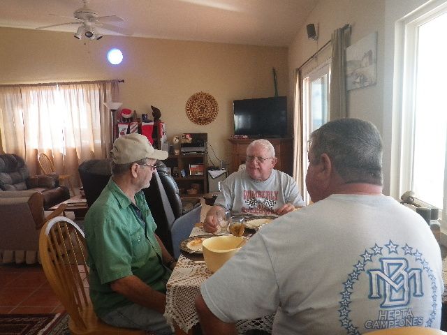
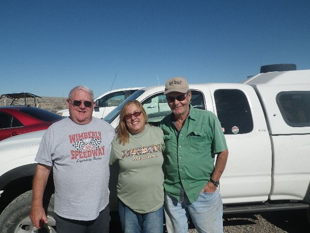
It was great to see Blanca and Les, Sheri and Juan, and have some great margaritas with motoged. We had breakfast in San Ignacio and when we got to La
Bocana Blanca had made lunch for us and Les made us set down and eat (1.5 hours after breakfast) well it was so good I had seconds. I'll probably
never lose weight this way. When we got to Shari's she offered to make us something to eat but we kindly declined and opted for ged's margaritas.
We left Bahia Asuncion and filled up in Vizcaino. North of there we hit fog until a few miles north of the state line. Slow going for a while. We
pulled into Cocos about 10pm. I was up at 6am and yelled at Roy at 6:30am to get up and get ready to leave. We had coffee with Coco and was on the
road at 7:30. up to Gonzaga then to San Felipe. North bound I talked Roy into crossing at the Mexicali east gate. It took us 50-60 min. I went north
on 86 to the 10 then the 210 to the 15. All lanes on the 15 were going about walking speed for several miles it seemed. Off on the 138 to Palmdale
then up to Mojave. Hwy 58 was closed due to an accident on the north side of Tehachapi so I had to take the Tehachapi Loop road to Keene then back on
the 58 and home. I got home at 10:30pm 15 hours on the road. I will not do that again.
|
|
|
TMW
Select Nomad
Posts: 10659
Registered: 9-1-2003
Location: Bakersfield, CA
Member Is Offline
|
|
I'm going to check my basecamp stuff to see if I left out a step.
|
|
|
BajaBlanca
Select Nomad
Posts: 13247
Registered: 10-28-2008
Location: La Bocana, BCS
Member Is Offline
|
|
We have had internet issues but YES, we saw the boys too! The stories are amazing! What an incredible life these two have had.
Les had cooked their lunch for them - since we didn't know which day they were coming, we kept making extra food every day for about three days. If
they thought they could leave without eating, well, that just wasn't possible:
This is us outside, just as they were about to leave:
Tom brought me a huge suitcase of clothes that had been sitting in mom's garage for a month. I took it over to the middle school where they are
raising money for various projects.
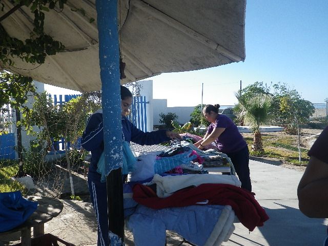
Here are two boys trying on a pair of pjs and a head warmer:
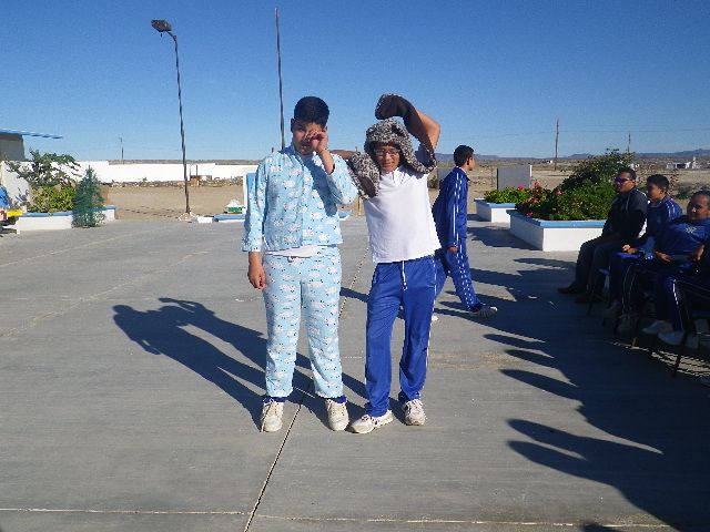
Thanks Tom and thanks Roy - for the clothes. for the dreams. for the laughter.
|
|
|
David K
Honored Nomad
Posts: 65565
Registered: 8-30-2002
Location: San Diego County
Member Is Offline
Mood: Have Baja Fever
|
|
Thank for the photos Blanca! Roy sure has made his Got Baja? hat last... that was from 10 years ago!
|
|
|
Ken Cooke
Elite Nomad
Posts: 8971
Registered: 2-9-2004
Location: Riverside, CA
Member Is Offline
Mood: Pole Line Road postponed due to injury
|
|
| Quote: Originally posted by David K | | Tom, maybe ask John M what he uses as his GPS track of race course is how he helped Ken Cooke and the rest of us find our way through that ejido east
of Guadalupe Canyon entrance at last year's Pole Line Run. |
That was a maze of bushes and dirt.
|
|
|
John M
Super Nomad
Posts: 1924
Registered: 9-3-2003
Location: California High Desert
Member Is Offline
|
|
GPS
I use a Lowrance GPS - the track we followed was provided me by Paul W.
John
|
|
|
PaulW
Ultra Nomad
Posts: 3113
Registered: 5-21-2013
Member Is Offline
|
|
Yes, I have a huge number of real tracks that I have driven. Mostly from L Salida south to Matomi. But I have numerous tracks for all of Baja.
I primarily use various Lowrance GPS's, but I also do tracks on my Garmin Montana 650t. The Lowrance is much easier and is compatible with most of
the stuff we share. I like John, Stuck, and other experienced people can convert back and forth with ease for all kinds of formats.
Get a GPS that can share tracks and then we can share them.
I think it is sad that with all the back country travel that you Nomads do and do not have tracks to share. Nuvi GPS's are not acceptable for this
purpose. Sorry.
|
|
|
ehall
Super Nomad
Posts: 1906
Registered: 3-29-2014
Location: Buckeye, Az
Member Is Offline
Mood: It's 5 o'clock somewhere
|
|
| Quote: Originally posted by PaulW | Yes, I have a huge number of real tracks that I have driven. Mostly from L Salida south to Matomi. But I have numerous tracks for all of Baja.
I primarily use various Lowrance GPS's, but I also do tracks on my Garmin Montana 650t. The Lowrance is much easier and is compatible with most of
the stuff we share. I like John, Stuck, and other experienced people can convert back and forth with ease for all kinds of formats.
Get a GPS that can share tracks and then we can share them.
I think it is sad that with all the back country travel that you Nomads do and do not have tracks to share. Nuvi GPS's are not acceptable for this
purpose. Sorry.
|
Have you had any luck converting gpx files to urs format for the old lowrances?
|
|
|
John M
Super Nomad
Posts: 1924
Registered: 9-3-2003
Location: California High Desert
Member Is Offline
|
|
Converting
I use GPS TrackMaker and as Paul says it's really easy to convert with and I use it on a rather old Lowrance "540 Baja"
John
[Edited on 12-17-2016 by John M]
|
|
|
mjs
Nomad
Posts: 335
Registered: 2-20-2013
Location: Off grid in San Felipe
Member Is Offline
|
|
I have found GPS Babel to work well. https://www.gpsbabel.org
|
|
|
John M
Super Nomad
Posts: 1924
Registered: 9-3-2003
Location: California High Desert
Member Is Offline
|
|
Babel
MJS - I used Babel for some time until Paul told me about the GPS TrackMaker - it's works much more easily than Babel in my opinion.
John
|
|
|
ehall
Super Nomad
Posts: 1906
Registered: 3-29-2014
Location: Buckeye, Az
Member Is Offline
Mood: It's 5 o'clock somewhere
|
|
Thanks, I will give it a shot.
|
|
|
TMW
Select Nomad
Posts: 10659
Registered: 9-1-2003
Location: Bakersfield, CA
Member Is Offline
|
|
You can convert just about any file to GE or GPX using gps visualizer at
http://www.gpsvisualizer.com/
That is how I converted Rich's GPS to Google Earth.
For Baja Off Road routes on my NUVI-52 I use CartoGrafia E32loading it using Garmin BaseCamp.
I found the problem of why Rich's GPS track didn't work on my NUVI, there was another step. I did not use "edit" and "send to" in BaseCamp.
I won't really know if it works until my next NWT run next year. But now my GPS show the two file in internal storage.
PUNTA SALINA 2 SAN FRANSITO and ST IGN 2 ENS/TNI BEACH
I think before I had just loaded them into BaseCamp and had not sent them to the GPS device.
|
|
|
BajaBlanca
Select Nomad
Posts: 13247
Registered: 10-28-2008
Location: La Bocana, BCS
Member Is Offline
|
|
Where are the photos from the trip?
|
|
|
PaulW
Ultra Nomad
Posts: 3113
Registered: 5-21-2013
Member Is Offline
|
|
As John said I have been using Trackmaker for many years. And yes I have used Babel, GPS viaualizer, and Ozi Explorer.
The main reason I use TM is it is easy to add WPs and to edit those side trips that are not applicable.
Back when I was making race tracks for SCORE/NORRA it was very common to go out an drive and try many ways for the course. Then I would go back home
and use TM to do the editing. Very easy and quick.
TM will not convert to the latest Lowrance Gen 3 format and so far I have not found any SW that will. I think the people doing that task have bought a
license? As you may have noticed SCORE does offer the Gen 3 tracks for their races.
My latest project is to use TM and GE Pro to measure distances between common places where I drive. The result is exact GPS mileages between places on
the track. Easy to do, but it does take some time jumping back and forth between the two. On vacation in Colorado so time is what I have these days.
|
|
|
rich t
Nomad
Posts: 102
Registered: 4-18-2016
Member Is Offline
|
|
TMW, glad to hear you made it thru with no problems, when your get the
tracks straightened out, you will find that the last day we came out is the
set of tracks that are the best to follow, that was my third pass thru there
because of the trip I did solo to San Ignacio and back with the gas for the
three other vehicles, I was scouting it out for a bike trip in March, but gas
was the biggest issue and thought it would be pretty tough to make it in one day on a bike from San Fransquito to San Ignacio, each time thru we
would find a little more of the original trail.
|
|
|
TMW
Select Nomad
Posts: 10659
Registered: 9-1-2003
Location: Bakersfield, CA
Member Is Offline
|
|
You are right Rich the bikers need to carry gas since it is 107 miles from Rancho La Ilusion gate to Hwy 1, then another 13 miles to San Ignacio.
Maybe less due to the cut off for the Rancho jct. Even with a 4 gallon tank on a four stroke it may be hard to make due to all the sand one would
travel thru. It is a kick in the butt ride for a bike. If you can fill them at El Barril or San Francisquito and also have a gas pit at El Gato would
be great. Many bikes have made it by carrying gas with them.
I think I have my GPS issues straightened out just waiting for the right time to test it.
|
|
|
rich t
Nomad
Posts: 102
Registered: 4-18-2016
Member Is Offline
|
|
TMW, did you try the track from San Fransquito to El Barril along the Beach?
|
|
|
| Pages:
1
2
3
4
5 |


