| Pages:
1
2
3
4
5 |
4x4abc
Ultra Nomad

Posts: 4456
Registered: 4-24-2009
Location: La Paz, BCS
Member Is Offline
Mood: happy - always
|
|
Quote: Originally posted by wilderone  | | En route to San Borja on that road there are some geoglyphs - keep an eye out for them (they cross the road, or rather, the road goes right through).
|
where where where?
lat/long?
Harald Pietschmann
|
|
|
JZ
Select Nomad
Posts: 14910
Registered: 10-3-2003
Member Is Offline
|
|
Here you go OP. A bunch of waypoints and tracks around BoLA. The file will load directly into Google Earth.
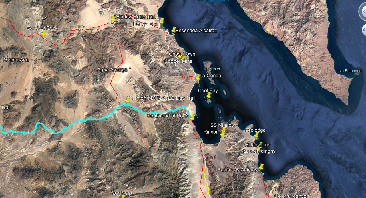
Attachment: Area Around BoLA.kmz (38kB)
This file has been downloaded 342 times
[Edited on 1-19-2020 by JZ]
|
|
|
micah202
Super Nomad
Posts: 1615
Registered: 1-19-2011
Location: vancouver,BC
Member Is Offline
|
|
Very nice,, though I'm wondering about the red lines,, your moto-tracks,, or doable in a raised minivan?
| Quote: Originally posted by JZ | Here you go OP. A bunch of waypoints and tracks around BoLA. The file will load directly into Google Earth.
[Edited on 1-19-2020 by JZ] |
|
|
|
JZ
Select Nomad
Posts: 14910
Registered: 10-3-2003
Member Is Offline
|
|
Sorry, I need to start color coding better.
Red trail up from MX 12 (paved road into BoLA from MX 1) up through the lake bed and then East to Ensenada Alactraz is easy in a truck. That's the
Window Rock trail (goes from MX 1 to the coast).
Going West on WR trail to MX 1 from the lake bed turn off is single track.
And going straight down South from Alactraz to La Gringa is single track or maybe a big time jeep - that's the red/white track.
All the rest of the red is fine for a truck, e.g. the places South of BoLA.
[Edited on 1-19-2020 by JZ]
|
|
|
micah202
Super Nomad
Posts: 1615
Registered: 1-19-2011
Location: vancouver,BC
Member Is Offline
|
|
I'm the first toadmit I'm a simpleton with computers,, but I can't for the life of me get your map link to open anywhere,,, GoogleEarthPro is
installed.
Attachment: Area Around BoLA.kmz (38kB).... shows some gibberish of Nomad when I cut paste it,, and clicky is no better. 
| Quote: Originally posted by JZ | | Here you go OP. A bunch of waypoints and tracks around BoLA. The file will load directly into Google Earth. |
[Edited on 1-19-2020 by micah202]
|
|
|
4x4abc
Ultra Nomad
Posts: 4456
Registered: 4-24-2009
Location: La Paz, BCS
Member Is Offline
Mood: happy - always
|
|
download the kmz file
you may want to create a dedicated folder for this, because you might get a lot of trip/location recommendations for Baja
open GoogleEarth
from the file menu select "Open..." and chose the downloaded kmz file
done
Harald Pietschmann
|
|
|
micah202
Super Nomad
Posts: 1615
Registered: 1-19-2011
Location: vancouver,BC
Member Is Offline
|
|
Dang,, I'm finding google earth really bogs down my data. The tablet just doesnt have enough gigs,, have to delete almost everything else, and the
desktop freezes.
So far, I've been finding 'Open street view, shows up back country roads the best, plus there's commentary added. IOverlander is similar.
For satelite view, I jump over to Google maps.
Google earth just stops ....everything. 
| Quote: Originally posted by 4x4abc | download the kmz file
you may want to create a dedicated folder for this, because you might get a lot of trip/location recommendations for Baja
open GoogleEarth
from the file menu select "Open..." and chose the downloaded kmz file
done
|
|
|
|
wilderone
Ultra Nomad
Posts: 3914
Registered: 2-9-2004
Member Is Offline
|
|
Re Geoglyphs on the San Borja backroad. I don't know location exactly. If you've been on that road, you know it goes through a lot of rocky stuff,
goes up and down and curves through some canyons. When you get to a mesa, or flatter terrain - maybe about 11-15 mi. from San Borja, is where they
would logically be. You'll at first think they're cattle tracks, but there aren't cattle tracks elsewhere like that. Also, they're too narrow for
cattle tracks and no hoofprints around, and not deep enough as would indicate continued use with cattle.
PS: Takes a LOT of fuel, and soak overnight to make some bland beans on a camping trip. Who does that. Can of refried black beans will do it for me.
Dehydrated split pea and black bean soup from Whole Foods. Great with a quesadilla.
|
|
|
David K
Honored Nomad
Posts: 65586
Registered: 8-30-2002
Location: San Diego County
Member Is Offline
Mood: Have Baja Fever
|
|
Just so there is no confusion, "Mexico Hwy. 12" is only on Google or Internet Maps. In reality, it has always (since 1974 when they began paving it)
been part of Mexico Hwy. 1. IF anyone sees a Mexico #12 sign down there on that road, please take a photo and post it!
|
|
|
David K
Honored Nomad
Posts: 65586
Registered: 8-30-2002
Location: San Diego County
Member Is Offline
Mood: Have Baja Fever
|
|
| Quote: Originally posted by wilderone | Re Geoglyphs on the San Borja backroad. I don't know location exactly. If you've been on that road, you know it goes through a lot of rocky stuff,
goes up and down and curves through some canyons. When you get to a mesa, or flatter terrain - maybe about 11-15 mi. from San Borja, is where they
would logically be. You'll at first think they're cattle tracks, but there aren't cattle tracks elsewhere like that. Also, they're too narrow for
cattle tracks and no hoofprints around, and not deep enough as would indicate continued use with cattle.
PS: Takes a LOT of fuel, and soak overnight to make some bland beans on a camping trip. Who does that. Can of refried black beans will do it for me.
Dehydrated split pea and black bean soup from Whole Foods. Great with a quesadilla. |
Do you think you are seeing a section of El Camino Real, rather than a geoglyph?
The Jesuits built their road in straight sections where ever the terrain permitted. Since they were removed less than 6 years after founding that
mission and only had begun the next mission at Calamajué a year before their removal, we generally don't see typical Jesuit roads north of San Borja,
just smaller trails, like cattle trails.
This map shows the road (blue) and El Camino Real (yellow) from the L.A. Bay highway south to Mission San Borja:

|
|
|
4x4abc
Ultra Nomad
Posts: 4456
Registered: 4-24-2009
Location: La Paz, BCS
Member Is Offline
Mood: happy - always
|
|
| Quote: Originally posted by micah202 | Dang,, I'm finding google earth really bogs down my data. The tablet just doesnt have enough gigs,, have to delete almost everything else, and the
desktop freezes.
So far, I've been finding 'Open street view, shows up back country roads the best, plus there's commentary added. IOverlander is similar.
For satelite view, I jump over to Google maps.
Google earth just stops ....everything.
|
are you using the web version of Google Earth or the standalone app?
Harald Pietschmann
|
|
|
4x4abc
Ultra Nomad
Posts: 4456
Registered: 4-24-2009
Location: La Paz, BCS
Member Is Offline
Mood: happy - always
|
|
| Quote: Originally posted by wilderone | Re Geoglyphs on the San Borja backroad. I don't know location exactly. If you've been on that road, you know it goes through a lot of rocky stuff,
goes up and down and curves through some canyons. When you get to a mesa, or flatter terrain - maybe about 11-15 mi. from San Borja, is where they
would logically be. You'll at first think they're cattle tracks, but there aren't cattle tracks elsewhere like that. Also, they're too narrow for
cattle tracks and no hoofprints around, and not deep enough as would indicate continued use with cattle.
PS: Takes a LOT of fuel, and soak overnight to make some bland beans on a camping trip. Who does that. Can of refried black beans will do it for me.
Dehydrated split pea and black bean soup from Whole Foods. Great with a quesadilla. |
north or west of San Borja?
Harald Pietschmann
|
|
|
micah202
Super Nomad
Posts: 1615
Registered: 1-19-2011
Location: vancouver,BC
Member Is Offline
|
|
...stand alone on the desktop,, tried the app on the tablet. <;~l
| Quote: Originally posted by 4x4abc | | Quote: Originally posted by micah202 | Dang,, I'm finding google earth really bogs down my data. The tablet just doesnt have enough gigs,, have to delete almost everything else, and the
desktop freezes.
So far, I've been finding 'Open street view, shows up back country roads the best, plus there's commentary added. IOverlander is similar.
For satelite view, I jump over to Google maps.
Google earth just stops ....everything.
|
are you using the web version of Google Earth or the standalone app? |
|
|
|
Alm
Ultra Nomad
Posts: 2756
Registered: 5-10-2011
Member Is Offline
|
|
| Quote: Originally posted by lencho | A traditional step in cooking Mexican beans is cleaning them before they go into the pot; nothing particular to L.A. Bay.
I think this may be a result of sourcing closer to the fields than in the U.S... |
Washed, rocks picked out, beans soaked overnight. Some rocks are still there when you eat it. A Mexican sitting and sorting it a few times would've
resolved the problem  . .
Sourcing closer to the fields... This would be the case with unmarked bags, but they were not too clean in sealed branded bags either. it's a
generally low standard of the industry. Haven't had that much dirt in the US-packed beans.
Ah, yes - rice - don't buy the one in unmarked bags either. Clear grocery bags tied in a knot, not sealed. Low grade rice with lot of fine
particulate matter, you rinse it several times and it's still foaming when cooking. Buy rice in branded bags - more expensive, but better. Or bring
from the US the brand that you trust. High pesticides load in non-organic rice is a concern too, I would imagine this situation being worse than
North of the border.
Groceries in this little town are delivered once a week. 2 days later and until the next delivery you get beef with brown stains of decay after
being kept in store fridge above 50F, rotten bananas and tomatoes (or none at all), and other pleasantries. Locals are traveling to Enesanda and GN
often, and bring everything they can from there.
|
|
|
micah202
Super Nomad
Posts: 1615
Registered: 1-19-2011
Location: vancouver,BC
Member Is Offline
|
|
Hmmm,, sounds like they could use a coupla family farms in there. Or even more regular deliveries.
Think of all the fuel burnt if each family is doing regular veg runs to ensenada. We -have- to start thinking of these things. <;~l
|
|
|
David K
Honored Nomad
Posts: 65586
Registered: 8-30-2002
Location: San Diego County
Member Is Offline
Mood: Have Baja Fever
|
|
The markets in L.A. Bay are not that sparsely stocked. Maybe chat with the Americans that live there if you need fresh produce to learn what day(s) of
the week new inventory arrives or if there is a produce vendor that comes one day.
|
|
|
JZ
Select Nomad
Posts: 14910
Registered: 10-3-2003
Member Is Offline
|
|
Here is an updated KMZ. Added the track into San Borja and also a track to a really nice beach at Ensenada Alcatraz.
Attachment: Area Around BoLA.kmz (41kB)
This file has been downloaded 300 times
[Edited on 1-19-2020 by JZ]
|
|
|
JZ
Select Nomad
Posts: 14910
Registered: 10-3-2003
Member Is Offline
|
|
| Quote: Originally posted by micah202 | Hmmm,, sounds like they could use a coupla family farms in there. Or even more regular deliveries.
Think of all the fuel burnt if each family is doing regular veg runs to ensenada. We -have- to start thinking of these things. <;~l
|
Ignore him. He's trying to save $20 by buying in bulk in Ensenada and/or hasn't been in a BoLA market in years.
[Edited on 1-19-2020 by JZ]
|
|
|
Paulina
Ultra Nomad
Posts: 3813
Registered: 8-31-2002
Location: BCN
Member Is Offline
|
|
One might think that some of the posters to this thread haven't shopped in Bahia since the 80s. Most of the markets in town have Ensenada Costco
products available. There is good beef and chicken available. Sometimes you have to ask if you don't see what you want. Fresh produce comes in on
Friday. You can expect the stores to have it out for sale on Saturday mornings. Fresh baked goods are available too. Tortillas show up twice a week,
no need to stop in Ensenada for them. If you want tri-tip or Prime cuts of beef, bring it with you. I'm not a picky eater but I have yet to find the
stores lacking. Shop local and support the economy. You won't go hungry.
P>*)))>{
\"Well behaved women rarely make history.\" Laurel Thatcher Ulrich
|
|
|
del mar
Banned
Posts: 1057
Registered: 7-23-2016
Location: the cantina of course
Member Is Offline
Mood: lil' fuzzy
|
|
| Quote: Originally posted by Paulina | One might think that some of the posters to this thread haven't shopped in Bahia since the 80s. Most of the markets in town have Ensenada Costco
products available. There is good beef and chicken available. Sometimes you have to ask if you don't see what you want. Fresh produce comes in on
Friday. You can expect the stores to have it out for sale on Saturday mornings. Fresh baked goods are available too. Tortillas show up twice a week,
no need to stop in Ensenada for them. If you want tri-tip or Prime cuts of beef, bring it with you. I'm not a picky eater but I have yet to find the
stores lacking. Shop local and support the economy. You won't go hungry.
P>*)))>{ |
so its not a steakless outpost where they put rocks in your beans and try to kill you with their rice?
|
|
|
| Pages:
1
2
3
4
5 |


